

NP 286(1) United Kingdom and Europe
.pdf

Contents Index
UNITED KINGDOM
CONTACT DETAILS:
Call: VTS Humber
Telephone: +44(0)1482 212191
Fax: +44(0)1482218773
Calling and Safety
VHF Frequency: Ch 16
VTS Area 1
VHF Frequency: Ch 14
VTS Area 2
VHF Frequency: Ch 12
VTS Area 3
VHF Frequency: Ch 15
Inlershlp (VTS Area 1)
VHF Frequency: Ch 13
Intershlp (VTS Areas 2 and 3)
VHF Frequency: Ch 10
HOURS:H24
PROCEDURE:
(1) Pilotage Is compulsory lor:
(al Vessels 01 SOm LOA and over within the Humber Pilotage Area
(b) Vessels 01 40m LOA and over above Grote (specialist River Ouse Pilot required)
(2) Pilotage Is exempt lor:
(a) Vessels less than 60m LOA within the Humber Pilotage Area. unless carrying a bulk cargo 01 dangerous substances as defined and categorised in the Dangerous Substances in Harbour Areas Regulations 1987
(b) Vessels under 40m LOA above Goole. unless carrying abulk cargo of dangerous substances as delined and categonsed in the Dangerous Substances in Harbour Areas Regulations 1987
(3) Pilot ordering by owners or agents lor both inward and outward passages must be given using 'Agents Online'.Orders for Pilots are not accepted by e·mail.VHF Ch 13 is the intership Channel lor the Humber Approaches and IS used lor communications between PVs and for vessels boarding and landing Pilots.
(4) Vessels Inward-bound from sea: All pilotage requirements should be passed through VTS Humber on VHF Ch 14.
(5) Notice of ETA: Owners or agents 01 Inward-bound vessels lor any port or berth within the Humber, Ouse or Trent requiring the services of an authorised Pilot must give at teast12h advance notice via 'AgentsOnline'to VTS Humber with ETA at the seaward limit 01 the Humber Pilotage Area stating the following inlormation:
(a) Vessel'sname
(b) Call sign
(c) Draught
(d) LOA
(e) DWT. GT and NT
(I) Air draught (ff vessel bound above Humber Bridge or the Steel Terminal at Hull or Goole)
(g) Billing agency
(h) Last port or anchorage
(i) ETA at Spurn Lt F
(j) Destination dock or berth
(k) Tugs ordered and tug company
(I) Cargo details, including haZardOUs cargo information (m)1I Pilot required and Pilot boarding position
(n) PEC number and name of holder
(0) AIr{ defects
(p) ISPS level
(q) Other information
(6) Vessels are required to confirm ETA on VHF Ch 14. not laler than 2'hhbefore arrival at Alpha It buoy (53°32'·82N0°13'·20E)The. 2~'2h notice is required under all circumstances and is not dependent on the availability or otherwise of a berth or berthing time.
(7) Masters 01 exempted vessels must also contact VTS Humber on VHF Ch 14 and advise ETA when 2',~h before arrival at Alpha Lt buoy. and also advise VTS Humber on the appropriate VHF Channel when passing the Reporting POints. when shifting between ports or berths, or when leaving any river berth or lock.
303

Contents Index
UNITED KINGDOM
(4) Tidal information is available on request for the following locations:
(a) Spurn Point
(b) Grimsby
(C) Irnmingham
(d) Hull
(e) Humber Bridge
(f) South Ferriby
(g) Brough
(h) West Walker Dyke
(i) Blacktoft
(j) GooIe
(k) Burton Stather
(t) F1ixborough
(m) Kea<l>y
CONTACT DETAILS:
Calling and Safety
Call: VTS Humber
VHF Frequency: Ch 16
VTS Areal
Call: VTS Humber
VHF Frequency: Ch 14
VTS Area 2
Call: VTS Humber
VHF Frequency: Ch 12
VTS Area 3
Call: VTS Humber
VHF Frequency: Ch 15
Vessel Traffic Service
Telephone: +44(0)1482212191
Fax: +44(0)1482218773
HrMr
Telephone: +44(0)1482327171
Fax: +44(0)1482 608432
Intershlp (VTS Area 1)
VHF Frequency: Ch 13
Intershlp (VTS Areas 2 and 3)
VHF Frequency: Ch 10
HOURS:H24
PROCEDURE:
(1) The following procedures are mandatory for all vessels over 50 GT and those carrying dangerous substances. inward·bound and outward-bound for the Rivers Humber, Ouse and Trent. All times should be given in local time (LT) using the 24h notation. See GENERAL NOTES for details of Dangerous Substances In Harbour Areas (DSHA) Regulations 1987.
(2) All vessels carrying dangerous or polluting goods as classified in the Inlemalional Maritime Dangerous Goods (IMoo) Code, in Chapter 19 of lhe International Gas
Carriers Code (IGC Code). in Chapter 17 of the International Bulk Carriers Code
(IBC Code) and MARPOL (Annexes I. II and III) should comply with the Merchant
Shipping (Traffic Monitoring and Reporting Requirements) Regulations
2004 (See GENERAL NOTES).
(3) Vessels sheltering. anchoring or moving within the River Humber should not transfer fuel. goods. spares. malerials or personnel belween vessels without first informing VTS Humber and obtaining the permission of the Hr Mr.
(4) Inward-bound vessels:
(al Notice of ETA: Vessels should send ETA to the Hr Mr through VTS Humber. at least 24h in advance or within 1hof departure lrom last port of call where such port of call is not situated within the Humber. stating Information listed in section
(5) under Pilots section.
(b) Vessels should give initial notice on VHF Ch 14 when 2\'211from Alpha Lt buoy. and maintain acontinuous watch on VHF Chs 14 and 16.
Ic) To avoid congestion on main operational VHF Channels. vessels upriver of No
4A Clee Ness Lt F. wishing to communicate with each other lintership) for the purposes of navigation only, should call on the appropriate VHF Channel and then move to VHF cn 10. Vessels seaward of No 4A Clee Ness Lt F should
move to VHF Ch 13. Masters and Pilols are nol required to keep a listening watch on these VHF Channels, but are required to maintain a listening watch on the main operational VHF Channels.
305

Contents Index
UNITED KINGDOM
(d)Vessels wishing to communicate with the VHF radio stations serving their destination should do so at the appropriate time on the VHF Channels shown in that section. Vessels are advised that when communicating with these stations. contact with VTS Humber can only be re·establishedthrough VHF Chs 12, 14. 15 and 16. Vessels must still report their departure on VHF Ch 14, 12 or 15 to VTSHumber.
(5)Reporting: Vessels are required to report to VTS Humber on:
(a)VHF Ch 14 in the Humber Approaches up to the meridian of longitude which passes through No 4A Clee Ness Lt F
(b)VHF Ch 12 upriver of the meridian of longitude which passes through No 4A Clee Ness Lt Funtil the Humber Bridge
(c)VHF Ch 15 upriver 01 the Humber Bridge
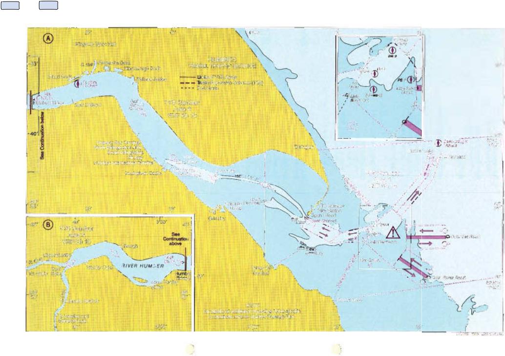
(6)Vessels should report to Humber VTS at the folowing Reporting Points:
|
Name |
Position |
Remarks |
|
VHFCh 14 |
|
|
||
|
Humber Lt F |
. 53°38'·70N |
|
|
|
0021'·24E |
|
||
|
|
|
||
, 1 |
Outer Sea Reach Lt buoy |
53°3NON |
i On entering the TSS |
|
|
||||
|
0022"90E |
|||
|
|
|
||
|
Outer Rosse Reach Lt buoy |
53°29'.SON |
|
|
|
0°20'.SOE |
|
||
2 |
~When Pilot embarked |
|
|
|
r--'; |
53°33'·50N |
I |
||
3 |
ISpurn Lt F |
I |
||
0°14'·2OE |
i |
|||
|
||||
4 |
When anchoring and not proceeding to a Humber Port |
|
||
Change to VHF Ch 12 |
|
|
||
5 |
IMeridian of longitude passing through No 4A Clee Ness Lt F |
|||
|
, |
53°3r·l0N |
! |
|
6 |
Sun" Spit Lt buoy |
|||
|
||||
|
|
OO04'·70W |
i |
|
7 |
No 19 (Paull Sand) Lt buoy |
53°42·.()()N |
Advise if intend using |
|
O·13'SOW |
Skiller Channel route |
|||
|
|
|||
Change to VHF Ch 15 |
|
I |
||
8 |
When passing the Humber Bridge |
I |
||
;9 |
iWhen passing Brough |
|
|
|
|
|
5J042'·OON |
Vessels entering the |
|
10 |
Trent Falls |
River Trent or River |
||
OO41'·10W |
||||
|
|
Ouse |
||
|
|
|
||
11 When passing Sketton Railway Bridge (River Ouse)
12 |
When passing Keadby Railway Bridge (River Trent) |
1 '3 |
When afl fast in any lock or on any berth |
r- Masters and Pilots are required to report when they are securely moored at
i |
their final berth of destination within the Humber Harbour Area. |
|
i
I
(7)Vessels intending to navigate the Sunk Dredged Channel should, before passing Spum Head (53°34'·OON O·06'·60E),ascertain from VTS Humber that the Dredged Channel is clear.
(8)Acontinuous listening watch whilst navigating in the River Humber should be kept as follows:
(a)VHF Ch 14: River Humber. Approaches up to No 4A Clee Ness Lt F
(b)VHF Ch 12: River Humber. upriver of No 4A Clee Ness Lt F
(e)VHF Ch 15: River Humber, upriver of the Humber Bridge
(9)Vessels at anchorage bound for a port or berth within the Humber must obtain clearance from VTS Humber before leaving anchorage and again when clearing
anchorage.
(10)Outward-bound vessels: Vessels should send ETD to the Hr Mr through VTS Humber, at least 2h before intention to navigate the Rivers Humber. Ouse and Trent stating information listed under Pilots section.
(11)All vessels should request clearance to sail from VTS Humber when either:
(a)Singled up and ready to let go from a river berth
(b)Prior to leaving alock when gates are open
(12)Having been given clearance to saito if any delay is then envisaged. the vessel should inlorm VTS Humber and seek further clearance when the cause of the delay is resolved.
(13)When clearance to sail has been granted by VTS Humber, the vessel should
proceed without delay providing the Master is satisfied that it is safe 10 do so. (14)Vessels should maintain a continuous listening watch on the appropriate VHF Channel and report to VTS Humber when passing the following Reporting Points
306

Contents Index
|
UNITED KINGDOM |
||
Name |
Position |
Remarks |
|
VHFCh 15 |
|
|
|
1 IWhen departing any lock or berth |
|
||
2 iWhen passing Keaclby Railway Bridge (River Trent) |
|
||
3 I When passing SkeHon Railway Bridge (River Ouse) |
|
||
4 ITrent Falls |
53°42',OON |
Vessels departing |
|
the River Trent or |
|||
OO41"10W |
|||
|
|
RiverOuse |
|
5 IWhen passing Brough Change to VHF Ch 12
6
When passing the Humber Bridge, advise if intend using Skitter Channel route
7 No 19 (Paull Sand) U buoy
53°42'·OON O'13'-8QW
8 No9AU F
53"38"OON
O·OS'30W
Change to VHF Ch 14
9 Meridian of longitude passing through No 4A Clee Ness LI F 10 When anchoring and not proceeding to sea
53"32'·4ON
0·13'·10E
53°38'·35N
O·22'4SE
13 53"32',70N On leaving the TSS O·22'·90E
53°29'·80N
OO20'·80E
(15) Vessels intending to navigate the Sunk Dredged Channel should. before passing No 9A LI F (53°38'·OON O°Q9'·3QW). ascertain from VTS Humber that the Dredged Channel is clear.
DEPARTING DEEP DRAUGHT VESSELS:
(1) Masters and Pilots are advised that on occasions it will be necessary for adeparting deep draught vessel which is constrained by its draught. to navigate against the traffic flow in that part of the Traffic Separation Scheme between Spurn Head and the Spurn
LlF.
(2) Vessels requiring to do this must first obtain permission from VTS Humber which will promulgate a broadcast and continue to warn shipping whilst the transit is being carried out.
INFORMATION BROADCASTS:
(1) Ageneral broadcast comprising weather reports. tidal information and navigational warnings is made by VTS Humber on VHF Chs 12, 14 and 15 every 2 hours commencing 0103 hours LT. prior notification being given on VHF Ch 16.
(2) The Sunk Dredged Channel is now dredged continuously, The Least Available Depth (LAD) will be announced by VTS Humber in their regular river broadcasts on VHF Chs 12, 14 and 15. Vessels requiring the latest information about depths in the Dredged Channel can obtain this ilformation from VTS Humber on request.
(3) In addition. in reduced visibility. frequent visibility reports for Spurn, Irnmingham and Hull are broadcast. Add~ional information regarding safety of navigation and movement of shipping can be obtained on request.
INCIDENT REPORTS:
(1) Any vessel within the Humber which:
(a) Has been involved in a collision with any vessel, navigational mark. bridge. shore faciHty or any other object or has been sunk or grounded (not being a vessel which is berthed or moored) or become stranded; or
(b) By reason of accidenl, fire, defect or otherwise is in such acondition as to affect its safe navigation or to give rise to danger to other vessels or property: or
(e) In any manner constitutes or causes an obstruction to afairway; should report the occurrence immediately to VTS Humber on VHF Ch 16 or the awroPria/e area VHF Channel stating:
(i) Vessel'sposition (ii) Known damage
(iii) Confirmation of cargo
(iv) Any injuries or loss of life
(v) Time 01 incident (vi) Draught 01 vessel (vii) Any pollution
307