

1 Definitions
Definitions 1
Categories of Messages
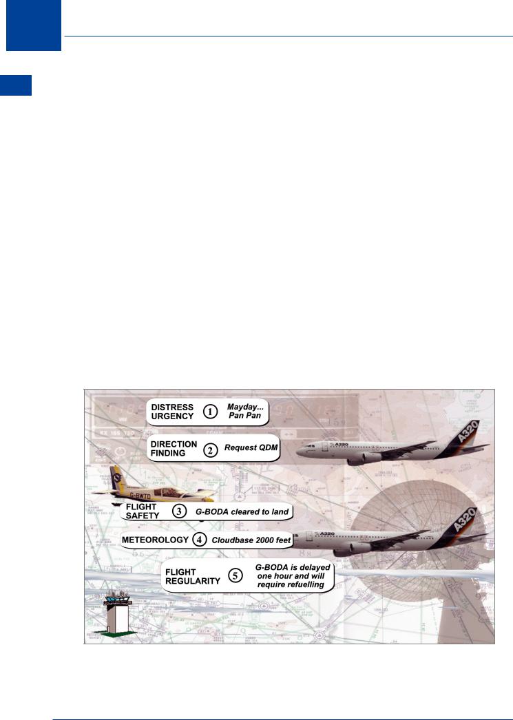
By convention, messages are placed into categories, so that if several need to be sent, the highest priority messages are sent first. This also applies to normal radio communications; for example, an aircraft emergency call takes priority over a request for landing. The messages have the following order of priority:
•Distress. (MAYDAY) A condition of being threatened by serious and/or imminent danger and of requiring immediate assistance.
•Urgency. (PAN PAN) A condition concerning the safety of an aircraft etc., but does not require immediate assistance, including messages preceded by the medical transports signal
– PAN PAN MEDICAL (see Chapter 5).
•Direction Finding. Communications relating to Direction Finding.
•Flight Safety. Messages of immediate concern to an aircraft in flight. Meteorological advice of immediate concern to aircraft in flight or about to depart. Other messages to aircraft in flight or about to depart.
•Meteorological Messages. Reports, forecasts and warnings.
•Flight Regularity. Messages regarding - operation or maintenance of facilities servicing changes in requirements for passengers and crew non routine landings aircraft parts or materials changes in aircraft operating schedules.
Figure 1.2
12
Definitions 1
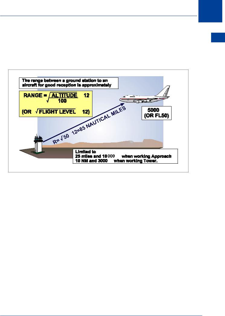
VHF Range
Finally, you need to know a little about the range that you can get with your VHF radio. This is covered in Chapter 2 of the Radio Navigation book. The range of VHF radio in nm is about 1.25 times the square root of the aircraft height in feet. Roughly, this works out about 12 times the square root of the flight level.
× |
|
× |
ft |
× |
|
|
ft |
|
ft |
Figure 1.3
The full formula, which also takes into account the height of the transmitting aerial when other than at mean sea level, is as follows:
|
|
|
|
|
|
|
|
|
Range = 1.23 × ( √h1 |
+ √h2 ) |
|||
where: |
h1 |
is the height of the ground aerial (feet AMSL) |
||||
|
h2 |
is the aircraft altitude (feet AMSL) |
||||
VHF Propagation is covered in greater detail in Chapter 7.
Definitions 1
13

1 Definitions
Definitions 1
Appendix 1A - Abbreviations Used in AIS Publications
†When radiotelephony is used, the abbreviations and terms are transmitted as spoken words.
‡When radiotelephony is used, the abbreviations and terms are transmitted using the individual letters in non-phonetic form.
A
A Amber
AAA(or AAB, AAC ... etc., in sequence) Amended meteorological message (message type designator)
A/A |
Air-to-Air |
AAL |
Above Aerodrome Level |
ABM |
Abeam |
ABN |
Aerodrome Beacon |
ABT |
About |
ABV |
Above |
AC |
Altocumulus |
ACARS |
Aircraft Communications Addressing and Reporting System |
ACAS |
Airborne Collision Avoidance Systems |
ACC‡ |
Area Control Centre OR Area Control |
ACCID |
Notification of an Aircraft Accident |
ACFT |
Aircraft |
AFS |
Aeronautical Fixed Service |
AFT |
After ... (time or place) |
AFTN‡ |
Aeronautical Fixed Telecommunication Network |
A/G |
Air-to-Ground |
AGA |
Aerodromes, Air Routes and Ground Aids |
AGL |
Above Ground Level |
AGN |
Again |
AGNIS |
Azimuth Guidance for Nose-In Stand |
14
AIAA |
Area of Intense Air Activity |
AIC |
Aeronautical Information Circular |
AIM |
ATFM Information Message |
AIP |
Aeronautical Information Publication |
AIRAC |
Aeronautical Information Regulation and Control |
AIREP† |
Air Report |
AIS |
Aeronautical Information Services |
ALA |
Alighting Area |
ACH |
Asymmetric Committed Height |
ACK |
Acknowledge |
ALERF |
Alert Phase |
ACL |
Altimeter Check Location |
ACN |
Aircraft Classification Number |
ACP |
Acceptance (message type designator) |
ACPT |
Accept OR Accepted |
ACT |
Active OR Activated OR Activity |
AD |
Aerodrome |
ADA |
Advisory Area |
ADDN |
Addition OR Additional |
ADF‡ |
Automatic Direction Finding Equipment |
ADGE |
Air Defence Ground Environment |
ADIZ† |
(pronounced ‘AY-DIZ’) Air Defence Identification Code |
ADJ |
Adjacent |
ADR |
Advisory Route |
ADS |
Automatic Dependent Surveillance |
ADSU |
Automatic Dependent Surveillance Unit |
ADT |
Approved Departure Time |
ADVS |
Advisory Service |
Definitions 1
Definitions 1
15

1 Definitions
Definitions 1
ADZ |
Advise |
AES |
Aircraft Earth Station |
AFIL |
Flight Plan Filed in the Air |
AFIS |
Aerodrome Flight Information Service |
AFM |
Yes OR Affirm OR Affirmative OR That is Correct |
ALR |
Alerting (message type designator) |
ALRS |
Alerting Service |
ALS |
Approach Lighting System |
ALT |
Altitude |
ALTN |
Alternate OR Alternating (Light alternates in colour) |
ALTN |
Alternate (Aerodrome) |
AMA |
Area Minimum Altitude |
AMD |
Amend OR Amended (used to indicate amended meteorological message; |
|
message type designator) |
AMDT |
Amendment (AIP Amendment) |
AMS |
Aeronautical Mobile Service |
AMSL |
Above Mean Sea Level |
AMSS |
Aeronautical Mobile Satellite Service |
ANM |
ATFM Notification Message |
ANS |
Answer |
AO |
Aircraft Operators |
AOC |
Aerodrome Obstacle Chart |
AOC |
Air Operator Certificate |
AOD |
Above Ordnance Datum (Newlyn) |
AOM |
Aerodrome Operating Minima |
AP |
Airport |
APAPI |
Abbreviated Precision Approach Path Indicator |
APCH |
Approach |
16

Definitions 1
APHAZ |
Aircraft Proximity Hazard |
APIS |
Aircraft Positioning and Information System |
APP |
Approach Control Office OR Approach Control OR Approach Control Service |
APR |
April |
APRX |
Approximate OR Approximately |
APSG |
After Passing |
APV |
Approve OR Approved OR Approval |
ARFOR |
Area Forecast (in aeronautical meteorological code) |
ARNG |
Arrange |
ARO |
Air Traffic Services Reporting Office |
ARP |
Aerodrome Reference Point |
ARP |
Air Report (message type designator) |
ARQ |
Automatic Error Correction |
ARR |
Arrive OR Arrival |
ARR |
Arrival (message type designator) |
ARS |
Special Air Report (message type designator) |
ARST |
Arresting (specify (part of) aircraft arresting equipment) |
AS |
Altostratus |
ASC |
Ascent to OR Ascending to |
ASDA |
Accelerate-Stop Distance Available |
ASPH |
Asphalt |
AT... |
At (followed by time at which weather change is forecast to occur) |
ATA‡ |
Actual Time of Arrival |
ATC‡ |
Air Traffic Control (in general) |
ATD‡ |
Actual Time of Departure |
ATFM |
Air Traffic Flow Management |
ATIS† |
Automatic Terminal Information Service |
ATM |
Air Traffic Management |
Definitions 1
17

1 Definitions
Definitions 1
ATN |
Aeronautical Telecommunication Network |
ATOTN |
Air Traffic Operation Telephone Network |
ATP |
At ...(time or place) |
ATS |
Air Traffic Service |
ATSU |
Air Traffic Service Unit |
ATTN |
Attention |
ATZ |
Aerodrome Traffic Zone |
AUG |
August |
AUTH |
Authorized OR Authorization |
AUW |
All Up Weight |
AUX |
Auxiliary |
AVASIS |
Abbreviated Visual Approach Slope Indicator System |
AVBL |
Available OR Availability |
AVG |
Average |
AVGAS |
Aviation Gasoline |
AVTUR |
Aviation Turbine Fuel |
AWTA |
Advise at What Time Available |
AWY |
Airway |
AZM |
Azimuth |
B |
|
B |
Blue |
BA |
Braking Action |
BAA |
British Airports Authority plc |
BASE† |
Cloud Base |
BCFG |
Fog Patches |
BCN |
Beacon (aeronautical ground light) |
BCST |
Broadcast |
BDRY |
Boundary |
18

Definitions 1
BECMG |
Becoming |
BFR |
Before |
BKN |
Broken |
BL... |
Blowing (followed by DU = Dust, SA = Sand or SN = Snow) |
BLDG |
Building |
BLO |
Below Clouds |
BLW |
Below |
BOMB |
Bombing |
BR |
Mist |
BRF |
Short (used to indicate the type of approach desired or required) |
BRG |
Bearing |
BRKG |
Braking |
B-RNAV† |
Basic - (pronounced ‘AR-NAV’) Area Navigation |
BS |
Commercial Broadcasting Station |
BTL |
Between Layers |
BTN |
Between |
C |
|
C |
Centre (runway identification) |
CAA |
Civil Aviation Authority |
CANP |
Civil Aircraft Notification Procedure |
CAP |
Civil Aviation Publication |
CAS |
Calibrated Airspeed |
CAT |
Category |
CAT |
Clear Air Turbulence |
CATZ |
Combined Aerodrome Traffic Zone |
CAVOK† |
(pronounced ‘KAV-OH-KAY’) |
|
Visibility, cloud and present weather better than prescribed values or |
|
conditions |
CB‡ |
(pronounced ‘CEE BEE’) Cumulonimbus |
Definitions 1
19

1 Definitions
Definitions 1
CBR |
Cloud Base Recorder (ceilometer) |
CC |
Counter Clockwise |
CC |
Cirrocumulus |
CCA |
(OR CCB, CCC ... etc., in sequence) Corrected Meteorological Message (message |
|
type designator) |
CD |
Candela |
CDN |
Coordination (message type designator) |
CDR |
Conditional Rout |
CEU |
Central Executive Unit |
CF |
Change Frequency to ... |
CFMU |
Central Flow Management Unit (Europe) |
CGL |
Circling Guidance Light(s) |
CHAPI |
Compact Helicopter Approach Path Indicator |
CH |
Channel |
CHG |
Modification (message type designator) |
CI |
Cirrus |
CIDIN† |
Common ICAO Data Interchange Network |
CIT |
Near OR over large towns |
CIV |
Civil |
CK |
Check |
CL |
Centre Line |
CLA |
Clear Type of Ice Formation |
CLBR |
Calibration |
CLD |
Cloud |
CLG |
Calling |
CLR |
Clear(s) OR Cleared to ... OR Clearance |
CLSD |
Close OR Closed OR Closing |
CM |
Centimetre |
20

Definitions 1
CMB |
Climb to OR Climbing to |
CMN |
Control Motion Noise |
CMPL |
Completion OR Completed OR Complete |
CNL |
Cancel OR Cancelled |
CNL |
Flight Plan Cancellation (message type designator) |
CNS |
Communications, Navigation and Surveillance |
Coded |
Centre Line lights of approach light system are coded |
COL |
Column (in tables and text) |
Colour |
Runway centre line lights are coloured red over the final 300 m and |
Coded |
alternately red/white in the penultimate 600 m |
COM |
Communications |
CONC |
Concrete |
COND |
Condition |
CONS |
Continuous |
CONST |
Construction OR Constructed |
CONT |
Continue(s) OR Continued |
COOR |
Coordinate OR Coordination |
CO-ORD |
Geographical Coordinates |
COP |
Changeover Point |
COR |
Correct OR Correction OR Corrected (used to indicate corrected meteorological |
|
message; message type designator) |
COSPAS |
Cosmos Rescue System (USSR) |
COT |
At the Coast |
COV |
Cover OR Covered OR Covering |
CPL |
Current Flight Plan (message type designator) |
CRM |
Collision Risk Model |
CRZ |
Cruise |
CS |
Cirrostratus |
Definitions 1
21

1 Definitions
Definitions 1
CTA |
Control Area |
CTAM |
Climb to and Maintain |
CTC |
Contact |
CTL |
Control |
CTMO |
Central Traffic Management Organisation |
CTN |
Caution |
CTOT |
Calculated Take-off Time |
CTR |
Control Zone |
CU |
Cumulus |
CUF |
Cumuliform |
CUST |
Customs |
CW |
Continuous Wave |
CWY |
Clearway |
D |
|
D... |
DME Range (prefix used in graphics) |
D |
DME Frequency pairing (used in graphics as a suffix to a VOR/ILS frequency) |
D... |
Danger Area (Followed by Identification) |
D |
Downward (tendency in RVR during previous 10 minutes) |
DA |
Decision Altitude |
DAAIS |
Danger Area Activity Information Service |
DACS |
Danger Area Crossing Service |
DBC |
Comecon Data Bank |
DBE |
Eurocontrol Data Bank |
DCD |
Double Channel Duplex |
DCKG |
Docking |
DCS |
Double Channel Simplex |
DCT |
Direct (In relation to flight path clearances and type of approach) |
DDM |
Difference in Depth of Modulation |
22

Definitions 1
DEC |
December |
DECR |
Decrease |
DEG |
Degrees |
DENEB |
Fog Dispersal Operations |
DEP |
Depart OR Departure |
DEP |
Departure (message type designator) |
DER |
Departure End of Runway |
DES |
Descend to OR Descending to |
DEST |
Destination |
DETR |
Department of the Environment, Transport and the Regions (UK) |
DETRESFA† |
Distress Phase |
DEV |
Deviation OR Deviating |
DF |
Direction Finding |
DFR |
Departure Flow Regulator |
DFTI |
Distance From Touchdown Indicator |
DH |
Decision Height |
DIF |
Diffuse |
DIST |
Distance |
DIV |
Divert OR Diverting |
DLA |
Delay OR Delayed |
DME‡ |
Distance Measuring Equipment |
DNG |
Danger OR Dangerous |
DOC |
Designated Operational Coverage |
DOM |
Domestic |
DP |
Dew Point Temperature |
DPT |
Depth |
DR |
Dead Reckoning |
DR... |
Low Drifting (followed by DU = Dust, SA = Sand or SN = Snow) |
Definitions 1
23

1 Definitions
Definitions 1
DRG |
During |
DS |
Dust Storm |
DSB |
Double Sideband |
DTAM |
Descend to and Maintain |
DTG |
Date-time Group |
DTRT |
Deteriorate OR Deteriorating |
DTW |
Dual Tandem Wheels |
DU |
Dust |
DUA |
Dedicated User Area |
DUC |
Dense Upper Cloud |
DUR |
Duration |
DVOR |
Doppler VOR |
DW |
Dual Wheels |
DZ |
Drizzle |
E |
|
E |
East OR Eastern Longitude |
EAT |
Expected Approach Time |
EB |
Eastbound |
ECAC |
European Civil Aviation Conference |
ED |
Emergency Distance (AD 1.1.1) |
EDT |
Estimated Departure Time |
EET |
Estimated Elapsed Time |
EFC |
Expected Further Clearance |
EFIS |
Electronic Flight Instrument System |
EHF |
Extremely High Frequency (30 000 to 300 000 MHz) |
ELBA† |
Emergency Location Beacon - Aircraft |
ELEV |
Elevation |
ELR |
Extra Long Range |
24
Definitions 1
ELT |
Emergency Locator Transmitter (GEN 3.6.6) |
EM |
Emission |
EMBD |
Embedded in a Layer (To indicate cumulonimbus embedded in layers of other |
|
clouds) |
EMERG |
Emergency |
END |
Stop End (related to RVR) |
ENE |
East North East |
ENG |
Engine |
ENRT |
En Route |
EOA |
Engine Out Allowance |
EOBT |
Estimated Off-Block Time |
EPIRB |
Emergency Position Indicating Radio Beacon |
EQPT |
Equipment |
ER |
Here ... OR Herewith |
ESE |
East South East |
EST |
Estimate OR Estimated OR Estimate (message type designator) |
ETA‡ |
Estimated Time of Arrival OR Estimating Arrival |
ETD‡ |
Estimated Time of Departure OR Estimating Departure |
ETO |
Estimated Time Over Significant Point |
ETOPS |
Extended Twin-jet Operations |
EV |
Every |
EXC |
Except |
EXER |
Exercises OR Exercising OR To Exercise |
EXP |
Expect OR Expected OR Expecting |
EXTD |
Extend OR Extending |
Definitions 1
25

1 Definitions
Definitions 1
F |
|
F |
Fixed |
FA |
Area Forecast (ARFOR) |
FAC |
Facilities |
FAF |
Final Approach Fix |
FAL |
Facilitation of International Air Transport |
FAP |
Final Approach Point |
FAT |
Final Approach Track |
FATO |
Final Approach and Take-off Area |
FAX |
Facsimile Transmission |
FBL |
Light (used to indicated the intensity of weather phenomena, interference or |
|
static reports, e.g. FBL RA = Light Rain) |
FBU |
Flight Briefing Unit |
FC |
Funnel Cloud (tornado or water spout) |
FCST |
Forecast |
FCT |
Friction Coefficient |
FEB |
February |
FG |
Fog |
FIC |
Flight Information Centre |
FIR‡ |
Flight Information Region |
FIS |
Flight Information Service |
FISA |
Automated Flight Information Service |
FL |
Flight Level |
FLAS |
Flight Level Allocation Scheme |
FLD |
Field |
FLG |
Flashing |
FLR |
Flares |
FLT |
Flight |
26

Definitions 1
FLTCK |
Flight Check |
FLUC |
Fluctuating OR Fluctuation OR Fluctuated |
FLW |
Follow(s) OR Following |
FLY |
Fly OR Flying |
FM |
From |
FM ... |
From (followed by time weather change is forecast to begin) |
FMS |
Flight Management System |
FMU |
Flow Management Unit |
FMP |
Flow Management Position |
FNA |
Final Approach |
FOQNH |
Forecast Regional QNH |
FPL |
Filed Flight Plan (message type designator) |
FPM |
Feet Per Minute |
FPR |
Flight Plan Route |
FR |
Fuel Remaining |
FREQ |
Frequency |
FRI |
Friday |
FRNG |
Firing |
FRONT† |
Front (Relating to Weather) |
FRQ |
Frequent |
FSL |
Full Stop Landing |
FSS |
Flight Service Station |
FST |
First |
FT |
Feet (Dimensional Unit) |
FTT |
Flight Technical Tolerance |
FU |
Smoke |
FZ |
Freezing |
FZDZ |
Freezing Drizzle |
Definitions 1
27

1 Definitions
Definitions 1
FZFG |
Freezing Fog |
FZRA |
Freezing Rain |
G |
|
G |
Green |
G/A |
Ground-to-Air |
G/A/G |
Ground-to-Air and Air-to-Ground |
GAT |
General Air Traffic |
Gauge |
Indicates distance between two rows of runway lights |
GCA‡ |
Ground Controlled Approach System OR Ground Controlled Approach |
GEN |
General |
GEN |
Generally |
GEO |
Geographic OR True |
GES |
Ground Earth Station |
GLD |
Glider |
GND |
Ground |
GNDCK |
Ground Check |
GNSS |
Global Navigation Satellite System |
GP |
Glide Path |
GR |
Hail |
GRASS |
Grass Landing Area |
GRID |
Processed meteorological data in the form of grid point values (in aeronautical |
|
meteorological code) |
GRVL |
Gravel |
GS |
Ground Speed |
GS |
Small hail and/or snow pellets |
GVS |
Gas Venting Site |
28

H |
|
H24 |
Continuous Day and Night Service |
H |
Helicopter |
HAPI |
Helicopter Approach Path Indicator |
HBN |
Hazard Beacon |
HDF |
High Frequency Direction Finding Station |
HDG |
Heading |
HEL |
Helicopter |
HF‡ |
High Frequency (3000 to 30 000 kHz) |
HGT |
Height OR Height Above |
HIAL |
Highlands and Islands Airports Ltd |
HI |
High Intensity directional lights |
HIRTA |
High Intensity Radio Transmission Area |
HJ |
Sunrise to Sunset |
HL |
Height Loss |
HLDG |
Holding |
HN |
Sunset to Sunrise |
HO |
Service available to meet operational requirements |
HOL |
Holiday |
HOPA |
Helicopter Operational Area |
HORIZ |
Horizontal |
HOSP |
Hospital Aircraft |
HPA |
Hectopascal |
HR |
Hours |
HS |
Service Available During Hours of Scheduled Operations |
HT |
High Tension (power) |
HTA |
Helicopter Training Area |
HURCN |
Hurricane |
Definitions 1
Definitions 1
29

1 Definitions
Definitions 1
HVDF |
High and Very High Frequency Direction Finding Stations (at the Same Location) |
HVY |
Heavy |
HVY |
Heavy (used to indicate the intensity of weather phenomena, e.g. HVY RA = |
|
Heavy Rain) |
HX |
No Specific Working Hours |
HYR |
Higher |
HZ |
Dust Haze |
Hz |
Hertz (cycles per second) |
I |
|
IAC |
Instrument Approach Chart |
IAF |
Initial Approach Fix |
IAO |
In And Out of clouds |
IAP |
Instrument Approach Procedure |
IAR |
Intersection of Air Routes |
IAS |
Indicated Air Speed |
IBN |
Identification Beacon |
IC |
Diamond Dust (very small ice crystals in suspension) |
ICE |
Icing |
ID |
Identifier OR Identify |
IDENT† |
Identification |
IF |
Intermediate Approach Fix |
IFF |
Identification Friend/Foe |
IFR‡ |
Instrument Flight Rules |
IGA |
International General Aviation |
ILS‡ |
Instrument Landing System |
IM |
Inner Marker |
IMC‡ |
Instrument Meteorological Condition |
IMG |
Immigration |
30

IMPR |
Improve OR Improving |
IMT |
Immediate OR Immediately |
INA |
Initial Approach |
INBD |
Inbound |
INC |
In Cloud |
INCR |
Increase |
INCERFA† |
Uncertainty Phase |
INCL |
Included OR Including OR Inclusive |
INFO† |
Information |
INOP |
Inoperative |
INP |
If Not Possible |
INPR |
In Progress |
INS |
Inertial Navigation System |
INSTL |
Install OR Installed OR Installation |
INSTR |
Instrument |
INT |
Intersection |
INTL |
International |
INTRG |
Interrogator |
INTRP |
Interrupt OR Interruption OR Interrupted |
INTSF |
Intensify or Intensifying |
INTST |
Intensity |
IR |
Ice on Runway |
ISA |
International Standard Atmosphere |
ISB |
Independent Sideband |
ISOL |
Isolated |
Definitions 1
Definitions 1
31

1 Definitions
Definitions 1
J |
|
JAN |
January |
JTST |
Jet Stream |
JUL |
July |
JUN |
June |
K |
|
KG |
Kilogrammes |
kHz |
Kilohertz |
KM |
Kilometres |
KMH |
Kilometres per Hour |
KPA |
Kilopascal |
KT |
Knots |
KW |
Kilowatts |
L |
|
L |
Left (runway identification) |
L |
Locator (NDB with published approach procedure, see LM, LO) |
LAM |
Logical Acknowledgement (message type designator) |
LAN |
Inland |
LARS |
Lower Airspace Radar Advisory Service |
LAT |
Latitude |
LATCC |
London Area and Terminal Control Centre |
LDA |
Landing Distance Available |
LDAH |
Landing Distance Available, Helicopter |
LDG |
Landing |
LDI |
Landing Direction Indicator |
LEN |
Length |
LF |
Low Frequency (30 to 300 kHz) |
LFA |
Low Flying Area |
32

Definitions 1
LFZ |
Low Flying Zone |
LGT |
Light or Lighting |
LGTD |
Lighted |
LHA |
Lowest Holding Altitude |
LHS |
Left Hand Side |
LI |
Low Intensity omnidirectional lights |
LIH |
Light Intensity High |
LIL |
Light Intensity Low |
LIM |
Light Intensity Medium |
LITAS |
Low Intensity Two Colour Approach Slope Indicators at .... and .... metres from |
|
threshold bracketing approach angle of degrees |
LLIZ |
Localiser |
LM |
Locator, Middle |
LMT |
Local Mean Time |
LNG |
Long (used to indicate the type of approach desired or required) |
LO |
Locator, Outer |
LOC |
Local OR Locally OR Location OR Located |
LONG |
Longitude |
LRG |
Long Range |
LSQ |
Line Squall |
LTD |
Limited |
LTT |
Landline Teletypewriter |
LUT |
Local User Terminal |
LV |
Light and Variable (relating to wind) |
LVE |
Leave OR Leaving |
LVL |
Level |
LVP |
Low Visibility Procedures |
LYR |
Layer OR Layered |
Definitions 1
33

1 Definitions
Definitions 1
M |
|
M |
Mach Number (followed by figures) |
M |
Metres (preceded by figures) |
MAA |
Maximum Authorized Altitude |
MAG |
Magnetic |
MAINT |
Maintenance |
MAP |
Aeronautical Maps and Charts |
MAPt |
Missed Approach Point |
MAR |
At sea |
MAR |
March |
MAS |
Manual A1 Simplex |
MATZ |
Military Aerodrome Traffic Zone |
MAX |
Maximum |
MAY |
May |
MB |
Millibars |
MCA |
Minimum Crossing Altitude |
MCW |
Modulated Continuous Wave |
MDA |
Minimum Descent Altitude |
MDF |
Medium Frequency Direction Finding Station |
MDH |
Minimum Descent Height |
MEA |
Minimum En route Altitude |
MEDA |
Military Emergency Diversion Aerodrome |
MVDF |
Medium and Very High Frequency Direction Finding Stations (at the same |
|
location) |
MEHT |
Minimum Eye Height over Threshold (For VASIS and PAPI) |
MWARA |
Major World Air Route Area |
MET† |
Meteorological OR Meteorology |
METAR† |
Aviation routine weather report (in aeronautical meteorological code) |
34
Definitions 1
MF |
Medium Frequency (300 to 3000 kHz) |
MHDF |
Medium and High Frequency Direction Finding Stations (at the same location) |
MHVDF |
Medium, High and Very High Frequency Direction Finding Stations (at the same |
|
location) |
MHz |
Megahertz |
MID |
Midpoint (related to RVR) |
MIFG |
Shallow fog |
MIL |
Military |
MIN |
Minutes |
MKR |
Marker radio beacon |
MLWA |
Maximum Landing Weight Authorized |
MLS‡ |
Microwave Landing System |
MM |
Middle Marker |
MNM |
Minimum |
MNPS |
Minimum Navigation Performance Specifications |
MNT |
Monitor OR Monitoring OR Monitored |
MNTN |
Maintain |
MOA |
Military Operating Area |
MOC |
Minimum Obstacle Clearance (required) |
MOD |
Moderate (used to indicated the intensity of weather phenomena, interference |
|
or static reports, e.g. MOD RA = Moderate Rain) |
MOGAS |
Motor Gasoline |
MON |
Above Mountains |
MON |
Monday |
MOTNE |
Meteorological Operational Telecommunications Network Europe |
MOV |
Move OR Moving OR Movement |
MPH |
Statute Miles Per Hour |
MPS |
Metres Per Second |
MRA |
Minimum Reception Altitude |
Definitions 1
35

1 Definitions
Definitions 1
MRG |
Medium Range |
MRP |
ATS/MET Reporting Point |
MS |
Minus |
MSA |
Minimum Sector Altitude |
MSD |
Minimum Separation Distance (mil) |
MSG |
Message |
MSL |
Mean Sea Level |
MT |
Mountain |
MTOW |
Maximum Take-off Weight |
MTRA |
Military Temporary Reserved Airspace |
MTU |
Metric Units |
MTW |
Mountain Waves |
MTWA |
Maximum Total Weight Authorized |
MWO |
Meteorological Watch Office |
MX |
Mixed type of ice formation (white and clear) |
N |
|
N |
North OR Northern latitude |
N |
No distinct tendency (in RVR during previous 10 minutes) |
NAT |
North Atlantic |
NATFMS |
National Air Traffic Flow Management System |
NAV |
Navigation |
NB |
Northbound |
NBFR |
Not Before |
NC |
No Change |
NDB‡ |
Non-Directional Radio Beacon |
NDS |
Non-deviating Status |
NE |
North East |
NEB |
North Eastbound |
36

Definitions 1
NEG |
No OR Negative OR Permission not granted OR That is not correct |
NGT |
Night |
NIL*† |
None OR I Have nothing to send you |
NM |
Nautical Miles |
NML |
Normal |
NNE |
North North East |
NNW |
North North West |
NOF |
International NOTAM Office |
NOSIG† |
No Significant Change (Used in trend-type landing forecasts) |
NOTAM† |
A notice containing information concerning the establishment, condition or |
|
change in any aeronautical facility, service, procedure or hazard, the timely |
|
knowledge of which is essential to personnel concerned with flight operations |
NOV |
November |
NR |
Number |
NRH |
No Reply Heard |
NS |
Nimbostratus |
NSC |
Nil Significant Cloud |
NSW |
Nil Significant Weather |
NW |
North West |
NWB |
North Westbound |
NXT |
Next |
O |
|
OAC |
Oceanic Area Control Centre |
OAS |
Obstacle Assessment Surface |
OAT |
Operational Air Traffic |
Obs |
Obstacle lights |
OBS |
Observe OR Observed OR Observation |
OBSC |
Obscure OR Obscured OR Obscuring |
OBST |
Obstacle |
Definitions 1
37

1 Definitions
Definitions 1
OCA |
Obstacle Clearance Altitude |
OCC |
Occulting (light) |
OCH |
Obstacle Clearance Height |
OCNL |
Occasional OR Occasionally |
OCS |
Obstacle Clearance Surface |
OCT |
October |
OHD |
Overhead |
OIS |
Obstacle Identification Surface |
OLR |
Off Load Routes |
OM |
Outer Marker |
OPA |
Opaque, white type of ice formation |
OPC |
The control indicated is Operational Control |
OPMET† |
Operational Meteorological (information) |
OPN |
Open OR Opening OR Opened |
OPR |
Operator OR Operate OR Operative OR Operating OR Operational |
OPS† |
Operations |
O/R |
On Request |
ORCAM |
Originator Region Code and Mode |
ORD |
Indication of an Order |
OSV |
Ocean Station Vessel |
OTLK |
Outlook (used in SIGMET messages for volcanic ash and tropical cyclones) |
OTP |
On Top |
OTS |
Organized Track System |
OUBD |
Outbound |
OVC |
Overcast |
38

P |
|
P... |
Prohibited area (followed by identification) |
PALS |
Precision Approach Lighting System (specify category) |
PANS |
Procedures for Air Navigation Services |
PAPA |
Parallax Aircraft Parking Aid |
PAPI† |
Precision Approach Path Indicator |
PAR‡ |
Precision Approach Radar |
PARL |
Parallel |
PAX |
Passenger(s) |
PCD |
Proceed OR Proceeding |
PCN |
Pavement Classification Number |
PDG |
Procedure Design Gradient |
PE |
Ice Pellets |
PEC |
Pressure Error Correction |
PER |
Performance |
PERM |
Permanent |
PH |
Public Holiday |
PIB |
Preflight Information Bulletin |
PJE |
Parachute Jumping Exercise |
PLA |
Practice Low Approach |
PLN |
Flight Plan |
PLS |
Passenger Load Supplement |
PLVL |
Present Level |
PN |
Prior Notice required |
PndB |
Perceived Noise Decibels |
PNR |
Point of No Return |
PO |
Dust Devils |
POB |
Persons on Board |
Definitions 1
Definitions 1
39

1 Definitions
Definitions 1
POSS |
Possible |
PPI |
Plan Position Indicator |
PPR |
Prior Permission Required |
PPSN |
Present Position |
PRI |
Primary |
PRKG |
Parking |
PRM |
Preferred Route Message |
PROB† |
Probability |
PROC |
Procedure |
PROV |
Provisional |
PS |
Plus |
PSG |
Passing |
PSN |
Position |
PSP |
Pierced Steel Plan |
PTN |
Procedure Turn |
PTS |
Polar Track Structure |
PWR |
Power |
Q |
|
QBI |
Compulsory IFR flight |
QDM‡ |
Magnetic Heading (zero wind) |
QDR |
Magnetic Bearing |
QFA |
Meteorological Forecast |
QFE‡ |
Atmospheric pressure at aerodrome elevation (OR at runway threshold) |
QFU |
Magnetic orientation of runway |
QNH‡ |
Altimeter subscale setting to obtain elevation when on the ground |
QTE |
True bearing |
QUAD |
Quadrant |
40

Definitions 1
R |
|
R |
Red |
R ... |
Restricted Area (followed by identification) |
R ... |
Radial (prefix for use in graphics) |
R |
Right (runway identification) |
R |
Rate of Turn |
RA |
Rain |
RA |
Resolution Advisory/Advisories (ACAS) |
RAC |
Rules of the Air and Air Traffic Services |
RAD |
Radar Approach Aid |
RAD |
Radius |
RAF |
Royal Air Force |
RAFC |
Regional Area Forecast Centre |
RAG |
Ragged |
RAG |
Runway Arresting Gear |
RAI |
Runway Alignment Indicator |
RAL |
Runway alignment beacon at distance from beacon threshold indicated |
RAS |
Radar Advisory Service |
RB |
Rescue Boat |
RCA |
Reach Cruising Altitude |
RCC |
Rescue Coordination Centre |
RCF |
Radio Communication Failure (message type designator) |
RCH |
Reach OR Reaching |
RCL |
Runway Centre Line |
RCLL |
Runway Centre Line Light(s) |
RCLR |
Recleared |
RDH |
Reference Datum Height (For ILS) |
RDL |
Radial |
Definitions 1
41

1 Definitions
Definitions 1
RDT |
Requested Departure Time |
RDO |
Radio |
RE... |
Recent (used to qualify weather phenomena, e.g. RERA = Recent Rain) |
REC |
Receive OR Receiver |
REDL |
Runway Edge Light(s) |
REF |
Reference to ... OR Refer to ... |
REG |
Registration |
RENL |
Runway End Light(s) |
REP |
Report OR Reporting OR Reporting Point |
REQ |
Request OR Requested |
RERTE |
Reroute |
RESA |
Runway End Safety Area |
RET |
Rapid Exit Taxiway |
RFF |
Fire and Rescue Equipment |
RG |
Range (lights) |
RHS |
Right Hand Side |
RIF |
Reclearance in Flight |
RIS |
Radar Information Service |
RITE |
Right (direction of turn) |
RIV |
Rapid Intervention Vehicle |
RL |
Report Leaving |
RLA |
Relay to |
RLCE |
Request Level Change En route |
RLLS |
Runway Lead-in Lighting System |
RLNA |
Requested Level Not Available |
RMK |
Remark |
RN |
Royal Navy |
RNAV† |
(pronounced ‘AR-NAV’) Area Navigation |
42

Definitions 1
RNG |
Radio Range |
RNP |
Required Navigation Performance |
ROBEX† |
Regional OPMET Bulletin Exchange (Scheme) |
ROC |
Rate of Climb |
ROD |
Rate of Descent |
ROFOR |
Route Forecast (in aeronautical meteorological code) |
RON |
Receiving Only |
RPL |
Repetitive Flight Plan |
RPLC |
Replace OR Replaced |
RPS |
Radar Position Symbol |
RQMNT |
Requirements |
RQP |
Request flight plan (message type designator) |
RQS |
Request supplementary flight plan (message type designator) |
RR |
Report Reaching |
RRA |
(OR RRB, RRC...etc., in sequence) Delayed meteorological message (message |
|
type designator) |
RSC |
Rescue Sub-Centre |
RSCD |
Runway Surface Condition |
RSP |
Responder beacon |
RSR |
En Route Surveillance Radar |
RSS |
Route Sum Square |
RTD |
Delayed (used to indicate delayed meteorological message; message type |
|
designator) |
RTE |
Route |
RTF |
Radiotelephone |
RTG |
Radiotelegraph |
RTHL |
Runway Threshold Light(s) |
RTN |
Return OR Returned OR Returning |
RTOAA |
Rejected Take-off Area Available |
Definitions 1
43

1 Definitions
Definitions 1
RTODA |
Rejected Take-off Distance Available |
RTR |
Radar Termination Range |
RTS |
Return to Service |
RTT |
Radio Teletypewriter |
RTZL |
Runway Touchdown Zone Light(s) |
RUT |
Standard regional route transmitting frequencies |
RV |
Rescue Vessel |
RVA |
Radar Vectoring Area |
RVR‡ |
Runway Visual Range |
RVSM |
Reduced Vertical Separation Minimum |
RWY |
Runway |
S |
|
S |
South OR Southern Latitude |
SA |
Sand |
SALS |
Simple Approach Lighting System |
SAN |
Sanitary |
SAP |
Soon As Possible |
SAR |
Search and Rescue |
SARPS |
Standards And Recommended Practices (ICAO) |
SARSAT |
Search and Rescue Satellite Aided Tracking System |
SAT |
Saturday |
SATCOM† |
Satellite Communication |
SB |
Southbound |
SC |
Stratocumulus |
SCN |
Slot Cancellation message |
SCT |
Scattered |
SDBY |
Stand By |
SDF |
Step Down Fix |
44
Definitions 1
SE |
South East |
SPECIAL† |
Special meteorological report (in abbreviated plain language) |
SEB |
South Eastbound |
SEC |
Seconds |
SECT |
Sector |
SPI |
Special Position Indicator |
SPL |
Supplementary flight plan (message type designator) |
SELCAL† |
Selective Calling system |
SPOT† |
Spot wind |
SQ |
Squall |
SEP |
September |
SER |
Service OR Servicing OR Served |
SH... |
Showers (followed by RA = Rain, SN = Snow, PL = Ice pellets, GR = Hail, GS = |
|
Small Hail and/or snow pellets or combinations thereof, e.g. SHRASN = Showers |
|
of Rain and Snow) |
SHF |
Super High Frequency (3000 to 30 000 MHz) |
SEV |
Severe (Used e.g. to qualify icing and turbulence reports) |
SFC |
Surface |
SFLOC |
Synoptic report of the location of sources of atmospherics |
SG |
Snow Grains |
SGL |
Signal |
SR |
Sunrise |
SRA |
Surveillance Radar Approach |
SRE |
Surveillance Radar Element of precision approach radar system |
SRG |
Short Range |
SRP |
Slot Reference Point |
SRQ |
Slot Request Message |
SRR |
Search and Rescue Region |
SRY |
Secondary |
Definitions 1
45

1 Definitions
Definitions 1
SS |
Sandstorm |
SS |
Sunset |
SSB |
Single Sideband |
SSE |
South South East |
SSR‡ |
Secondary Surveillance Radar |
SST |
Supersonic Transport |
SHINGALS |
Supplementary High Intensity Narrow Gauge Approach Lighting System |
SID† |
Standard instrument Departure |
SIF |
Selective Identification Feature |
STA |
Straight-in Approach |
STAR† |
Standard instrument arrival |
SIGMET† |
Information concerning en route weather phenomena which may affect the |
|
safety of aircraft operations |
STD |
Standard |
STF |
Stratiform |
STN |
Station |
STNR |
Stationary |
SIGWX |
Significant Weather |
SIMUL |
Simultaneous OR Simultaneously |
SIWL |
Single Isolate Wheel Load |
SKC |
Sky Clear |
SKED |
Schedule OR Scheduled |
SLAP |
Slot Allocation Procedure |
SLP |
Speed Limiting Point |
SLT |
Slot Allocation Message |
SLW |
Slow |
SMB |
Side Marker Boards |
SMC |
Surface Movement Control |
46

Definitions 1
SMR |
Surface Movement Radar |
SN |
Snow |
SNOWTAM† |
A special series NOTAM notifying the presence or removal of hazardous |
|
conditions due to snow, ice and slush, or standing water associated with snow, |
|
ice and slush, on the movement area, by means of a specific format |
SOC |
Start of Climb |
Sodium Box |
Sodium approach lights arranged in box formation |
SPECI† |
Aviation selected special weather report (in aeronautical meteorological code) |
SPECIAL† |
Aviation selected special weather report (in abbreviated plain language) |
SSW |
South South West |
ST |
Stratus |
STOL |
Short Take Off and Landing |
STS |
Status |
STWL |
Stopway Light(s) |
SUBJ |
Subject to |
SUN |
Sunday |
SUP |
Supplement (AIP Supplement) |
SUPPS |
Regional supplementary procedures |
SVC |
Service message |
SVCBL |
Serviceable |
SVCE |
Service |
SVFR |
Special Visual Flight Rules |
SW |
South West |
SWB |
South Westbound |
SWY |
Stopway |
Definitions 1
47

1 Definitions
Definitions 1
T |
|
T |
Temperature |
TA |
Transition Altitude |
TACAN† |
UHF Tactical Air Navigation Aid |
TAF† |
Terminal Aerodrome Forecast |
TAIL† |
Tail wind |
TAR |
Terminal Area Surveillance Radar |
TAS |
True Airspeed |
TAX |
Taxiing OR Taxi |
TBC |
Tactical Booking Cell |
TC |
Tropical Cyclone |
TCU |
Towering Cumulus |
TDA |
Temporary Danger Area |
TDO |
Tornado |
TDZ |
Touch Down Zone |
TECR |
Technical Reason |
TEL |
Telephone |
TEMPO† |
Temporary OR Temporarily |
TFC |
Traffic |
TGL |
Touch-and-Go Landing |
TGS |
Taxiing Guidance System |
THR |
Threshold |
THRU |
Through |
THU |
Thursday |
TIL† |
Until |
TIP |
Until past ... (place) |
TKOF |
Take-off |
TL... |
Till (followed by time by which weather change is forecast to end) |
48

Definitions 1
TLOF |
Touchdown and Lift-off Area |
TMA‡ |
Terminal Control Area |
TNA |
Turn Altitude |
TNH |
Turn Height |
TO |
To... (place) |
TOC |
Top of Climb |
TODA |
Take-off Distance Available |
TODAH |
Take-off Distance Available, Helicopter |
TOP† |
Cloud Top |
TORA |
Take-off Run Available |
TOS |
Traffic Orientation Scheme |
TOSA |
Take-off Space Available |
TP |
Turning Point |
TR |
Track |
TRA |
Temporary Reserved Airspace |
TRA |
Temporary Restricted Area |
TRANS |
Transmits OR Transmitter |
TRL |
Transition Level |
TROP |
Tropopause |
TS |
Thunderstorm (in aerodrome reports and forecasts, TS used alone means |
|
thunder heard, but no precipitation at the aerodrome) |
TS ... |
Thunderstorm (followed by RA = Rain, SN = Snow, PL = Ice pellets, GR = Hail, |
|
GS = Small Hail and/or snow pellets or combinations thereof, e.g. TSRASN = |
|
Thunderstorm with Rain and Snow) |
TT |
Teletypewriter |
TTA |
Tactical Training Areas |
TTT |
Template Training Technique |
TUE |
Tuesday |
TURB |
Turbulence |
Definitions 1
49

1 Definitions
Definitions 1
TVOR |
Terminal VOR |
TWIL |
Twilight (civil) |
TWR |
Aerodrome control tower OR aerodrome control |
TWY |
Taxiway |
TWYL |
Taxiway Link |
TYP |
Type of Aircraft |
TYPH |
Typhoon |
U |
|
U |
Upward (tendency in RVR during previous 10 minutes) |
UA |
Air Report (AIREP) |
UAB |
Until Advised By .... |
UAC |
Upper Area Control Centre |
UAR |
Upper Air Route |
UDF |
Ultra High Frequency Direction Finding Station |
UFN |
Until Further Notice |
UHDT |
Unable Higher Due Traffic |
UHF‡ |
Ultra High Frequency (300 to 3000 MHz) |
UIC |
Upper Information Centre |
UIR‡ |
Upper Flight Information Region |
UKLFS |
United Kingdom Low Flying System |
ULR |
Ultra Long Range |
UNA |
Unable |
UNAP |
Unable to Approve |
UNL |
Unlimited |
UNREL |
Unreliable |
U/S |
Unserviceable |
UTA |
Upper Control Area |
UTC‡ |
Coordinated Universal Time |
50

Definitions 1
V |
|
VA |
Volcanic Ash |
VAC |
Visual Approach Chart |
VAL |
In Valleys |
VAN |
Runway Control Van |
VAR |
Magnetic Variation |
VAR |
Visual-Aural Radio Range |
VASIS† |
Visual Approach Slope Indicator System |
VC |
Vicinity of aerodrome (followed by FG = Fog, FC = Funnel Cloud, SH = Showers, |
|
PO = Dust/sand whirls, BLDU = Blowing Dust, BLSA = Blowing Sand or BLSN = |
|
Blowing Snow, e.g. VC FG = Vicinity Fog) |
VCY |
Vicinity |
VDF |
Very High Frequency Direction Finding Station |
VER |
Vertical |
VFR‡ |
Visual Flight Rules |
VHF‡ |
Very High Frequency (30 to 300 MHz) |
VIP‡ |
Very Important Person |
VIS |
Visibility |
VLF |
Very Low Frequency (3 to 30 kHz) |
VLR |
Very Long Range |
VMC‡ |
Visual Meteorological Conditions |
VM(C) |
Visual Manoeuvring (Circling) |
VOLMET† |
Meteorological information for aircraft in flight |
VOR‡ |
Very High Frequency Omnidirectional Radio Range |
VORTAC† |
VOR and TACAN combination |
VOT |
VOR airborne equipment test facility |
VRB |
Variable |
VRP |
Visual Reference Point |
VSA |
By visual reference to the ground |
Definitions 1
51

1 Definitions
Definitions 1
VSP |
Vertical Speed |
VSTOL |
Very Short Take-Off and Landing |
VTOL |
Vertical Take-Off and Landing |
W |
|
W |
West or Western longitude |
W |
White |
WAC |
World Aeronautical Chart - ICAO 1:1 000 000 (1 mil) |
WAFC |
World Area Forecast Centre |
WB |
Westbound |
WBAR |
Wing Bar lights |
WDI |
Wing Direction Indicator |
WDSPR |
Widespread |
WED |
Wednesday |
WEF |
With Effect From OR Effective From |
WI |
Within |
WID |
Width |
WIE |
With Immediate Effect OR Effective Immediately |
WILCO† |
Will Comply |
WINTEM |
Forecast upper wind and temperature for aviation |
WIP |
Work in Progress |
WKN |
Weaken or Weakening |
WNW |
Wet North West |
WO |
Without |
WPT |
Waypoint |
WRDA |
Weapon Range Danger Area |
WRNG |
Warning |
WS |
Windshear |
WSW |
West South West |
52

WT |
Weight |
WTSPT |
Waterspout |
WX |
Weather |
X |
|
X |
Cross |
XBAR |
Crossbar (of approach lighting system) |
XNG |
Crossing |
XS |
Atmospheres |
Y |
|
Y |
Yellow |
YCZ |
Yellow Caution Zone (runway lighting) |
YR |
Your |
Z |
|
Z |
Coordinated Universal Time (in meteorological messages) |
Definitions 1
Definitions 1
53

1 Definitions
Definitions 1
54