- •SECTION 1: System Overview
- •1.1 PFD/MFD Controls
- •1.2 PFD Softkeys
- •1.3 MFD Softkeys
- •1.4 MFD Page Groups
- •1.5 Backlighting
- •1.6 XM Radio - Automatic Muting
- •Section 2: FLIGHT INSTRUMENTS
- •2.1 Airspeed Indicator
- •Speed Indication
- •Speed Ranges
- •Airspeed Trend Vector
- •Vspeed References
- •2.2 Attitude Indicator
- •2.3 Altimeter
- •Altitude Reference Bug
- •Altitude Trend Vector
- •Barometric Setting Box
- •2.4 Vertical Deviation/Glideslope Indicator
- •2.5 Marker Beacon Annunciations
- •2.6 Vertical Speed Indicator
- •2.7 Horizontal Situation Indicator (HSI)
- •Course Pointer
- •Course Deviation Indicator (CDI)
- •Bearing Pointers and Information Windows
- •DME Radio (optional)
- •Navigation Source
- •3.1 Engine Display
- •3.2 Lean Engine Display
- •3.3 Engine System Display
- •4.1 Radio Status Indications
- •4.2 Volume
- •4.3 Automatic Squelch
- •4.4 Quickly Activating 121.500 MHz
- •4.5 Optional NAV Radios
- •DME Radio (optional)
- •ADF Radio (optional)
- •Auto-tuning on the PFD
- •Auto-tuning on the MFD
- •4.7 Transponder
- •Mode Selection
- •Ground Mode (Automatic)
- •Reply Status
- •Code Selection
- •Flight ID Reporting
- •5.1 COM Radio Selection
- •5.2 Marker Beacon Receiver
- •Marker Beacon Signal Sensitivity
- •5.3 Nav Radio Audio Selection
- •5.4 Intercom System (ICS) Isolation
- •5.5 Intercom Squelch Control
- •5.6 Digital Clearance Recorder with Playback Capability
- •Section 7: Navigation
- •7.1 Navigation Map Page
- •Select the MAP Page Group
- •Direct-to Navigation from the MFD
- •Direct-to Navigation from the PFD
- •7.3 Airport Information
- •Select the Airport Information Page
- •Enter a Waypoint Facility Name or City Location:
- •Access Runway Information
- •Access Frequency Information
- •7.4 Intersection Information
- •Select the Intersection Information Page
- •Access Information on an Intersection
- •7.5 NDB Information
- •Select the NDB Information Page
- •7.6 VOR Information
- •Select the VOR Information Page
- •Access Information on a VOR:
- •7.7 User Waypoint Information Page
- •7.8 Nearest Airports
- •Nearest Airport Information on the MFD
- •Nearest Airports Information on the PFD
- •7.9 Nearest Intersections
- •Select the Nearest Intersections Page
- •View Information on the Nearest Intersection
- •7.10 Nearest NDB
- •Select the Nearest NDB Page
- •7.11 Nearest VOR
- •Select the Nearest VOR Page
- •View Information on the Nearest VOR:
- •Select and Load a VOR Frequency
- •7.12 Nearest User Waypoint
- •Select the Nearest User Waypoint Page
- •Select a Nearest User Waypoint
- •7.13 Nearest Frequencies
- •Select the Nearest Frequencies Page
- •7.14 Nearest Airspaces
- •Select the Nearest Airspaces Page
- •Airspace Alerts Box
- •View Additional Details for a Listed Airspace
- •View and Quickly Load the Frequency for a Controlling Agency
- •sECTION 8: fLIGHT PLANNING
- •8.1 User Defined Waypoints
- •Select the User WPT Information Page
- •Create a New User Waypoint
- •Create User Waypoints from the Navigation Map Page
- •Modify a User Waypoint
- •Delete a User Waypoint
- •8.2 Viewing the Active Flight Plan
- •8.3 Activate a Stored Flight Plan
- •8.4 Activate a Flight Plan Leg
- •8.5 Stop Navigating a Flight Plan
- •8.6 Invert Active Flight Plan
- •8.7 Create a New Flight Plan
- •8.8 Load a Departure
- •8.9 Load an Arrival
- •8.10 Load an Approach
- •8.12 Store A Flight Plan
- •8.13 Edit a Stored Flight Plan
- •8.14 Delete a Waypoint from the Flight Plan
- •8.15 Invert and activate a Stored Flight Plan
- •8.16 Copy a Flight Plan
- •8.17 Delete a Flight Plan
- •8.18 Graphical Flight Plan Creation
- •8.19 Trip Planning
- •Section 9: Procedures
- •9.1 Arrivals and Departures
- •Load and Activate a Departure Procedure
- •Load and Activate An Arrival Procedure
- •9.2 Approaches
- •Load and/or Activate an Approach Procedure
- •Activate An Approach in the Active Flight Plan
- •Section 10: Hazard Avoidance
- •10.1 Customizing the Hazard Displays on the Navigation Map
- •10.2 STORMSCOPE® (Optional)
- •Displaying Stormscope Lightning Data on the Navigation Map Page
- •Stormscope Page
- •10.3 XM Weather (Service Optional)
- •Displaying Weather on the Weather Data Link Page
- •NEXRAD Limitations
- •Weather Product Age
- •10.4 Traffic Information Service (TIS)
- •TIS Audio Alert
- •10.5 Traffic Advisory System (TAS) (Optional)
- •System Self Test
- •10.6 Terrain And Obstacle Proximity
- •Displaying Terrain and Obstacles on the Terrain Proximity Page
- •11.1 Reversionary Mode
- •11.2 Abnormal COM Operation
- •11.3 Unusual Attitudes
- •12.1 Alert Level Definitions
- •12.2 NAV III Aircraft Alerts
- •Voice Alerts
- •WARNING Alerts
- •CAUTION Alerts
- •12.3 G1000 System Annunciations
- •MFD & PFD Message Advisories
- •Database Message Advisories
- •GMA 1347 Message Advisories
- •GIA 63 Message Advisories
- •GIA 63 Message Advisories (Cont.)
- •GEA 71 Message Advisories
- •GTX 33 Message Advisories
- •GRS 77 Message Advisories
- •GMU 44 Message Advisories
- •GDL 69 Message Advisories
- •GDC 74A Message Advisories
- •Miscellaneous Message Advisories
- •Index
2.Press the ACT LEG softkey (using MFD only). OR
3.Press the MENU key, select the ‘Activate Leg’ option from the page menu and press the ENT key. This step must be used when activating a leg from the PFD.
4.With ‘Activate’ highlighted, press the ENT key.
SECTION 8 – FLIGHT PLANNING
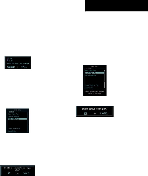
8.6INVERT ACTIVE FLIGHT PLAN
1.From the Active Flight Plan Page, press the MENU key to display the Page Menu.
2.Turn the large FMS knob to highlight ‘Invert Flight Plan’ and press the ENT key. The original flight plan remains intact in its flight plan catalog storage location.
3.With ‘OK’ highlighted, press the ENT key to invert the flight plan.
Figure 8-5 Activate Flight Plan Leg Confirmation
8.5STOP NAVIGATING A FLIGHT PLAN
1.Press the FPL key and turn the small FMS knob to display the Active Flight Plan Page.
2.Press the ENT key to display the Page Menu window.
Figure 8-6 Delete Flight Plan
3.Turn the large FMS knob to highlight ‘Delete Flight Plan’ and press the ENT key. With ‘OK’ highlighted, press the ENT key to deactivate the flight plan. This will not delete the stored flight plan, only the active flight plan.
Figure 8-8 Invert Flight Plan
Figure 8-9 Invert Flight Plan Confirmation
8.7CREATE A NEW FLIGHT PLAN
To create a new flight plan using the MFD:
1.Press the FPL key and turn the small FMS knob to display the Flight Plan Catalog Page.
2.Press the NEW softkey to display a blank flight plan page for the first empty storage location.
Figure 8-7 Delete Flight Plan Confirmation
Garmin G1000 Cockpit Reference Guide for the Cessna Nav III |
8-3 |