

CHAPTER ONE
PHYSICAL GEOGRAPHY
Jennifer R. Pournelle
Of all the natural factors that impact (or are impacted by) human activity, to fully understand the multi-millennial settlement history of ancient Sumer (and – perhaps more importantly – to understand what of that history is archaeologically visible), it is crucial to understand the dynamic interplay of water and sediments through rivers and marshes, levees and plains, lagoons and estuaries, and, finally, the sea. For without these elements, much of what came to be distinctly “Sumerian” simply
would not have been.
THE LAY OF THE LAND
The physical stage on which the drama of Sumer’s rise was played was set toward the end of the Pleistocene epoch. As the earth warmed, vast rivers fed by melting ice and heavy rains carved their way through the earlier sediments that had infilled the alluvial basin between the Zagros Mountains of Iran and the Arabian plateau. They dumped those sediments into the Shatt al-Arab valley, creating the floor of what is now the Arab-Persian Gulf. Throughout the early Holocene, even newer sediments then infilled those channel scours. For the most part, this re-leveled the basin floor – in some places burying the earlier surface beneath tens of meters of alluvial sands and silt; in others leaving older remnants exposed, like turtles’ backs rising above the still waters of a pond. Over time, the interplay of tectonic uplift and subduction with rising and falling sea levels, rivers and floods, and windborne sand scouring its way across that silty plain shaped and re-shaped optimal zones for a variety of biological (including human) activities.
An unstable foundation
Water drainage throughout southern Iraq is controlled by a great downward flexure that results from slippage of the Arabian plate beneath the upward-thrusting Iranian Zagros Mountains. This slippage forms an unstable shelf upon which Quaternary alluvial sediments were deposited (Aqrawi, Domas, and Jassim 2006) (Figure 1.1a). The topology of this warped bedrock ultimately influences not only hydrology, but also sedimentation, marine incursion, marsh formation, and the likelihood of archaeological sites being preserved and visible at the surface.
13
–– Jennifer R. Pournelle ––
While the entire Mesopotamian zone tips slightly from the northwest (at Samarra) to the southeast (at Basrah), its plane is also twisted northeast toward the Zagros as it is subducted below the great mass of those mountains. Between Najaf and Kut, it further twists west to east along an oblique fault zone. It then turns southeast to follow the course of the Samarra–Amara divide. Finally, near Zubair (old Basra), it assumes a uniform, north-to-south trend (Figure 1.1b).
Thus, waters of the Tigris, down-cutting as they drop onto the alluvium at Samarra, tend to flow south-southeast, always seeking the lowest ground along the base of the Zagros piedmont. Waters of the Euphrates tend to flow west to east, eventually joining those of the Tigris. Both rivers then empty into the Shatt al-Arab estuary, and continue southwards until encountering the Gulf. The combined outflows, passing southward, are slowed by the Zubair sill, behind which fresh water tends to pond, and to which tidal action extends.
A narrow exit
To the west, the alluvial shelf is defined by an abrupt rise in elevation of 10–20 meters to a Miocene limestone plateau, punctuated by small step faults that are most easily visible on the surface at Hit (Buday and Jassim 1987). During wetter periods and seasons, those faults funnel intermittent streams falling from the plateau, creating sediment fans below their nick points, as is clearly visible for the Wadi al-Khar near Hit (Figure 1.1c). The most dramatic of these fans is that of the Plio-Pleistocene Wadi Batin fluvial cone. During drier periods and seasons, windborne sand pours down from the plateau, forming dune fields that are pushed southeastward ahead of prevailing winds (Al-Dabi et al. 1997) (Figure 1.1d). In aggregate, these sediments constrain southerly flow of water, reinforcing the Euphrates’ easterly trend in its search for an outlet to the Gulf (Aqrawi, Domas, and Jassim 2006).
The Mesopotamian Zone’s eastern boundary is sharply demarcated by the folded uplands of the Zagros piedmont. Piedmont sediments, carried downstream during pluvial periods, have deeply buried that boundary in a series of merged alluvial fans that tend to push Tigris waters southward from their southeast-trending flow (Mashkour et al. 2004; Baeteman, Dupin, and Heyvaert 2004/2005). Thus, as the Shatt al-Arab crests the Zubair sill en route to the Gulf, it passes through a sedimentframed bottleneck, where much mixing, scouring, and re-leveling of sediment occurs during river floods and marine incursions.
Alluvial waters and the prograding delta
Understanding the deep structural effects of this twisted bedrock on hydrology and sediment deposition is fundamental to understanding the processes of the twin rivers’ metamorphoses through time. From the eighth millennium BC, at their point of emergence onto the alluvium, the Tigris and Euphrates appear always to have had anastomosing and significantly intermingled flows. Attempts to reconstruct portions of the major fluvial systems from Samarra to Sippar (Northedge, Wilkinson, and Falkner 1989), from Sippar to Kish and Babylon (Cole and Gasche 1998), in the vicinity of Abu Salabikh (Wilkinson 1990), from Isin and Mashkan-Shapir to Ur (Stone 2002), in the vicinities of Nippur and Wasit (Hritz 2010), and from Nippur and Mashkan-
14
–– Physical geography ––
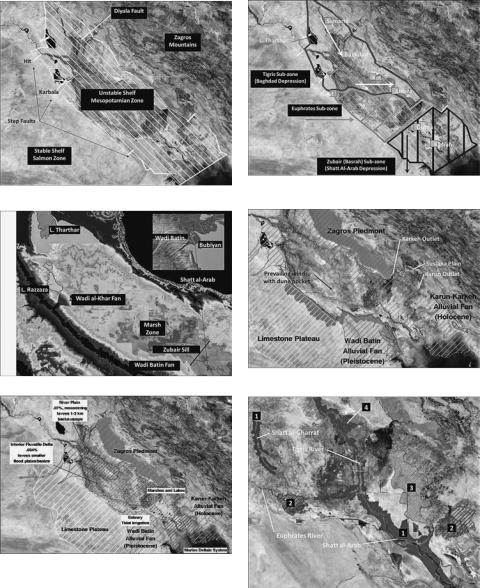
Figure 1.1 (a) The Mesopotamian Zone geosyncline (white hachure) forms where the Arabian plate is forced below the Zagros Mountains. Image: NASA 2001b MODIS. (b) Mesopotamian Zone tectonic subunits. Arrows, hachure indicate tilt direction. (c) Mesopotamian alluvial topology, showing sharp drop to the unstable shelf, and southeast trend tilted toward the Zagros from L. Tharthar to the Gulf. The Wadi al-Khar’s alluvial fan tends to push Euphrates water eastward. Fresh water ponds behind, and tidal flushing extends inland to the Zubair sill (black bar). Manually retouched mosaic of NIMA DTED0 1° quadrangles, with ENVITM 3.5 linear stretch (16:243) applied. (d) Boundary uplands. (e) The Shatt al-Arab deltaic system. After Verhoeven 1998, Sanlaville 2003. (f) Contemporary (1) Levees, (2) Crevasse splays,
(3) Alluvial soils, (4) Bird’s foot delta. Box: see Figure 1.2a.
15
–– Jennifer R. Pournelle ––
Shapir to Uruk (Steinkeller 2001) do not indicate the proportion of the Tigris’ overall contribution to alluvial settlement and irrigation before the third–second millennia BC. However, there is no evidence that either river established its present meandering channel beds at the latitude of Felluja and Baghdad before the early second millennium (Verhoeven 1998: 160; Heyvaert and Baeteman 2008). Even then, at least one branch of the Euphrates still flowed eastward to the Tigris (Gasche and Tanret 1998). How then should we interpret physical evidence for hints of the rivers’ earlier evolution?
As the surface slope of alluvial channels levels off – either because the land itself levels, or because their channels empty into a large body of water – river beds undergo threshold changes from braided, to meandering, to straight or sinuous, with the latter in some cases assuming multi-channel, anastomosed patterns (Baker 1986: 257–259 and figs. 4–5; Schumm and Khan 1972). Thus, in Mesopotamia, braided channels are typical of the arid uplands, where the Tigris and Euphrates are deeply incised into the Syrian and Arabian plateaus. However, on dropping from those stable shelf lands into the alluvium, the slope abruptly diminishes to less than 1 percent. There, the rivers assume meandering courses through the river floodplain, within fairly stable banks (Figure 1.1e).1 Over time, as they alternately carve through and re-deposit silts, sands, and gravels, these meanders leave fossil traces up to several kilometers wide, characterized by concentric stripes on their crests (Gasche and Tanret 1998: 5–7). Those contours can be preserved for millennia, due in part to their durable function in shaping subsequent agricultural systems, as they delineate systems of irrigation dikes and levees that both trap silt and demarcate field and crop boundaries. Down the upper Mesopotamian alluvium, such relict meandering systems are visible within the relatively narrow belts of their archaic floodplains (Pournelle 2003a).
This leaves in question whether, where, and to what extent it is possible to associate any relict channels with earlier periods. The Ur III period Tigris/Euphrates admixtures mentioned above could have existed in substantially the same beds for millennia. Conversely, subsequent sediments and channel migrations may have obliterated any (surface) remains. To assess which of these scenarios is more likely, we must first note that, on passing from the slightly tilted Tigris sub-zone to the nearly flat Euphrates subzone, the slope falls to less than 0.5 percent. There, along the transecting slip faults, the Tigris and Euphrates rivers tend to branch into multiple, sinuous distributaries with weak banks. From this point southeastward, channels leave few (if any) relict meander scrolls. Instead, connectivity among levees, avulsive splays, and deltaic mouths must be used to chart relict river systems.
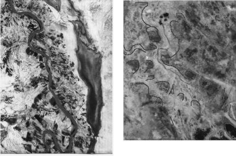
Most sediments are dropped in flood deposits along river distributaries, over time building broad, weak levees. Today, the largest of such alluvial levees lines the Shatt alArab, where the conjoined rivers form an estuary once famed for its millions of date palms (since destroyed during the Gulf Wars) (Figure 1.1f). Because alluvial soils comprise the best-drained agricultural soils (Buringh 1960; Wirth 1962), direct association of these levees with past agricultural activity is common (Wilkinson 2003) (Figure 1.2a and b). Chains of sites situated along their tops can indicate the system date, as for those of the second millennium BC systems of the Third Dynasty of Ur analyzed by Hritz (Hritz and Pournelle in press).
Where weak levees break (or are broken by human intervention), avulsions can become the source of new or diverted main channel flows (Figure 1.2c). However, just as often, the sudden fanning drops sufficient silt that the natural levees reestablish
16
–– Physical geography ––
when floodwaters recede. Sites located at the head of floodsplays, where dramatic annual flooding would make permanent habitation hazardous and unlikely, can serve as a termini post quem for active inundation from the breach, and thus the system of which they form a part. However, sites located within such splays are ideally situated to take advantage of floodbasin cultivation and pasturage (Pournelle and Algaze in press) (Figure 1.2d).
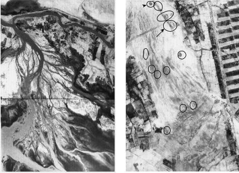
Finally, as rivers abruptly slow on encountering slack water, they dump their remaining sediment loads, resulting in the multiple, bifurcating channels of a “bird’s foot” delta, with newly deposited sediments becoming webs of marshland between the toes (Figure 1.3a). This can be seen at Warka (Uruk), where satellite photos reveal the city’s placement not so much on the river as in it: the city’s walls are clearly surrounded by a relict bird’s foot delta extending into spring 1968 Euphrates floodwaters (Figure 1.3b).
Through time, this process of channel bifurcation, sediment dumping, and channel extension builds sediment lobes that infill older channels around turtlebacks (the isolated fragments of older surfaces that protrude above the floodplain) and contribute to channel-flipping (as distributaries become blocked by their own sediments). To better understand this dynamic interaction of water and sediments over time, we must consider the profound effects of sea level on the hydrological regime.
Figure 1.2 (a) Tigris south of Amara (Qalat Salih-al-Azair). The cultivated agricultural zone extends outward from the water channel along the levee system. Excess water drains through lightcolored tails of smaller canal levees into seasonal back swamps visible as silty, dark grey bodies. Only two centuries ago these rice fields were year-round marshlands (Westphal-Hellbusch and Westphal 1962: 39–40). (b) Outlines demarcate relict levee between sites WS375 and WS400. Better-consolidated levee soils are less waterlogged, and hence appear lighter in color. CORONA KH4B_1103-1A-D041-055; KH4B_1103-1A-D041-058 (May 1968).
17
–– Jennifer R. Pournelle ––
901
902
Figure 1.2 (continued) (c) The Kut barrage on the Tigris between Sheikh Sa’ad and Ali al-Gharbi drains floodwaters into Lake as Sa’adiya (Haur as Sa’adiya). The barrage maintains and augments a natural avulsion (floodsplay) (compare Buringh 1960: 181). As floodwaters recede, wetland villages (circles) stockpile fodder (reeds and grasses), and transhumant pastoralists graze livestock en route to the Zagros piedmont. (d) Flanked by modern fields, a relict avulsion south of
Wilaya is cross-cut by more recent Parthian–Sassanian canals associated with sites WS901 (Tell Abu Khay) and WS902, dated to the first–second century AD (Adams 1981). Sites (circled) within the splay are unsurveyed, but Stone (2002) dates the relict Tigris watercourse that fed it to Isin-Larsa/Old Babylonian (second millennium BC).
CORONA KH4B_1103-1A-D041-050/51; KH4B_1103-1A-D041-052 (May 1968)
In describing the environmental setting wherein Sumer came to be, the significance of sea level rise is often misunderstood. Neither identifying “the” shoreline at a specific year nor deciding where sites and settlements might have been drowned is of paramount importance. In terms of human habitation and environmental exploitation, the ocean’s rise and fall is most significant in its see-saw effect on the rivers’ debouchment into the Gulf. When ocean levels drop, the rivers’ gradients increase and their water flow speeds up, leading to upstream downcutting, and downstream sediment dumping, that rapidly builds out (progrades) the rivers’ alluvial fans. When sea levels stabilize, head-to-tail slope levels off, and the rivers slow. As they do, more sediment accumulates within their floodplains, along their levees, and across their existing deltas, creating ideal conditions for formation of freshwater marshlands and brackish estuaries.
18
–– Physical geography ––
A B
Ur Gate and levee
Basra Gate and levee
Figure 1.3 (a) Amara, straddling Tigris distributaries arrayed in a bird’s foot delta extending into surrounding marshlands (Buringh 1960: 187). (b) Warka (ancient Uruk), straddling a relict bird’s foot delta extending into spring Euphrates floodwaters (black). As late summer heat dries surrounding marshes and lowers the water table, lower areas and infilled drainage are marginally wetter, and therefore darker. Less permeable, higher, and drier built-up areas, levees, and consolidated canal beds appear lighter in tone. CORONA KH4B_1103-1A-D041-065
(May 1968); KH4B_1107-2170DA-139 (August 1969).
Marine incursion, backswamps, marshes, and estuaries
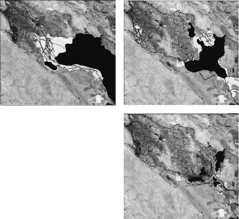
From the early Holocene, after rising at a (geologically) “rapid” rate of about 1.8 cm per year for two millennia, by 6150 (cal) BC the head of the Arab-Persian Gulf reached approximately its current level. For the next three centuries, throughout the ‘Ubaid 0, that rate slowed. At that time, ancient marshes extended as far southeast as Tello (Girsu), and the rivers laid down sediments in the Euphrates Valley from Ur to Fao (Bird et al. 2010; Aqrawi and Evans 1994; Aqrawi 1995; Hritz, Pournelle, and Smith 2012a). For the next four centuries, as sea level rise slowed to a near halt, the delta expanded, and marshes continued to form. Following this interim stillstand, by 5450 (cal) BC, sea level rise resumed at a rate of a half-meter per century (a half-centimeter per year), and continued to do so for the next millennium.
Through the remainder of the ‘Ubaid, the sea rose another 2–4 m, reaching a highstand of approximately 2.5 m above that of today. By 4550 (cal) BC, the sea had completely swamped the Euphrates Valley and the ancient marshes, and extended as far inland as Ur (Figure 1.4, Figure 1.7). Thus, at the dawn of the Uruk period, the Gulf having halted at its maximum level, the rivers began another round of marshand delta-building, stretching inland at least as far as the foundations of Uruk itself (Aqrawi 2001; Brückner 2003; Plaziat and Sanlaville 1991). Sea levels remained stable throughout the Uruk and Jemdat Nasr, regressed slightly at the beginning of the Early Dynastic, and then returned to their highstand. That eustatic stability over roughly two millennia had profound implications for that area called “the heartland of cities” by Robert McC. Adams in his definitive 1981 study (Adams 1981). Before Adams, the presumption that cities arose on the Mesopotamian alluvium because of mastery of
19
–– Jennifer R. Pournelle ––
irrigation technologies, with concomitant increases in grain (especially barley) production. Adams envisioned a more complex urban hinterland, comprising grain agriculture, livestock husbandry, and exploitation of marshes and backswamps, all important to urban survival, but in that relative order. Nevertheless, he opposed the more certain views of those who would, for the Sumerian case, reverse those relative roles, placing a deltaic heartland at the Sumerian core (e.g. Oates 1960).
Mighty winds: aeolian deflation and site visibility
Whence came this enduring presumption that irrigation went hand-in-hand with Sumer’s emergence? Aside from the obvious (that early cities now lie scoured by arid winds in a desert landscape), undue reliance was placed on two bodies of evidence.
The first of these was textual. Because the earliest towns and cities were preor proto-literate, insight into their organization and social relations was sought in cuneiform texts from much later periods. Related to this, because early excavations were primarily concerned with delineation of architecture and recovery of objects, little or no environmental evidence was observed or recorded. Thus, any discrepancy between evidence for the physical environs of early Sumer, as compared to that a millennium or more later, went unnoticed.The second was the corpus of data derived from extensive archaeological surface surveys. Seeking to understand the origins and development of civilizations in the alluvial lowlands of the Tigris, Euphrates, and their tributaries, over the course of two decades scholars conducted broad-scale regional settlement surveys that located, recorded, and dated thousands of archaeological sites. Guided by the later texts, they then attempted to associate these to relict water courses that intricately lace the region (Adams 1965, 1981; Wright 1981; Adams and Nissen 1972; Gibson 1972; Ur, this volume). Prior to these studies, it had been generally thought that heavy alluvial deposits over the lower Mesopotamian alluvium would have made it impossible to determine the origins of deeply buried cities (Nützel 1978). However, the surface surveys showed that this was not necessarily the case. In some cases, wind erosion periodically re-exposed long-buried artifacts that, when systematically collected, dated, mapped, and plotted with reference to ancient canal traces, revealed a distinct pattern of urbanization and extension of irrigation technology over a period of five millennia.2 The surveyors thereby constructed a broad view of long-term settlement patterns and demographic change in the Mesopotamian lowlands from the beginnings of settled towns to the present day. Adams’ work is especially well known for its clarification of how the natural environment of the area affected human life, what changing strategies Mesopotamian societies used throughout history to adapt to that environment, how successive Mesopotamian societies transformed that environment, and what selective environmental pressures existed in the region that favored the development of the world’s earliest urban societies (Adams 1981).
Nevertheless, the results of these efforts must be interpreted with care for several reasons. Most obviously, those surveys were conducted within bounded areas. Anything outside those boundaries remains, comparatively speaking, archaeological terra incognita. Second, following Jacobsen’s attempt to reconstruct the main watercourses of ancient southern Mesopotamia from textual sources (Jacobsen 1958), and presuming the necessity of irrigation, Adams undertook his survey in large part to identify waterways and canals, using extensive ground survey and aerial photography (Pournelle 2007). And, while in some areas he documented hundreds of deserted canals associated with
20
–– Physical geography ––
ESTUARIES
MARSHES
GULF
LAGOON
ESTUARIES
GULF
MARSHES
LAGOON
ESTUARIES
MARSHES
LAGOON
MARSHES
MARSHES
MARSHES
GULF
GULF
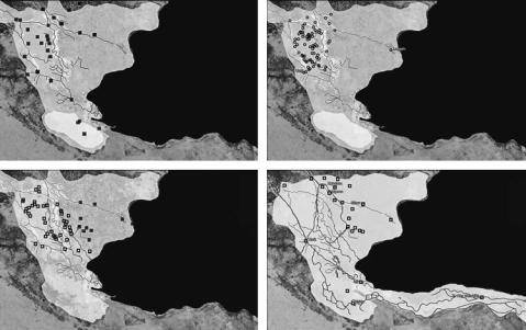
Figure 1.4 The Mesopotamian Delta, c.5000–3000 BC. (a) Maximum marine transgression coincides with the ‘Ubaid 4–Early Uruk transition c.4500 BC, leading to formation of a (freshwater) inner delta in the “heartland” basin, and freshwater lagoon in the Eridu basin, transitioning to a fresh–brackish mixing zone and outer delta in the East Gharraf basin. Visible sites of this era are situated either on turtlebacks, or within the deeply deflated areas of the “heartland.” (b) Sites newly visible as of the Middle Uruk. Sites are clustered where the rivers meet and freshwater marshes would become perennial. (c) Sites newly visible as of the Late Uruk–Jemdet Nasr. These follow the prograding delta to the southeast – up to the eastern margin of the surveyed zone. (d) Sites as of the Early Dynastic. The cluster to the northeast may indicate a new delta lobe. Any other sites to the east or southeast would fall outside of the surveyed area.
archaeological sites, he merely hypothesized linear connections among many others – especially for those of earlier periods, for which no direct evidence was visible.3
Finally, even within the survey boundaries, sites were unevenly exposed. As noted, they are apparent at all because of aeolian deflation of later river and canal levees, which formed dune fields that then scoured their way across the plain. In some cases, this destroyed archaeological sites entirely. In others, it barely scraped the top of the surface, revealing more recent material, but leaving the older foundations buried. In still others, it buried sites utterly–or, alternatively, left archaeological features pedestaled above the deflated surface, standing on columns of sediments protected from deflation by archaeological debris (Wilkinson 2003; Pournelle 2003b).
Thus, while the corpus of archaeological survey data for Mesopotamia succeeded in adding a corrective rural and non-literate dimension to the predominantly urban, literate, elite focus of previous excavations and cuneiform texts – which texts themselves have long influenced interpretation of the archaeological data – we must now consider the implications of the facts that inside the “heartland” survey zone we are left with an uneven patchwork of exposures, while outside it we know only the few major mounds plotted by Iraq’s Department of Antiquities.
21
–– Jennifer R. Pournelle ––
URBAN TRENDS
Early foundations: the ‘Ubaid
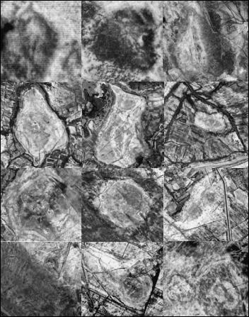
During the Neolithic Ubaid 0 (6500–4900 BC), archaeologically visible early villages in the southern Mesopotamian alluvium were concentrated on river levees at locations bordering swamps and marshes. Many of these early sites continued to be occupied into the Chalcolithic Ubaid 4 (4900–4350 BC), accounting for half of the sites known in the Warka and Eridu survey areas for that period. Of the newly founded sites, all but one were situated on exposed surfaces of Pleistocene “turtlebacks” that once overlooked anastomosing distributaries subject to seasonal flooding. Innumerable smaller, scattered sites may be buried beneath the Holocene deposits. These Ubaid towns presaged an explosion of newly visible sites founded during the Early Uruk period, when virtually all identifiable turtlebacks became inhabited (Safar, Mustafa, and Lloyd 1981; Huot et al. 1981; Pournelle 2007) (Figure 1.4a, Figure 1.5).
WS 230 |
|
1 km |
|
Umma |
|
1 km |
|
WS 125 |
|
1 km |
|
|
|
|
|
|
|
|
|
|
|
Girsu |
|
1 km |
|
Lagash |
|
1 km |
|
Nina |
|
1 km |
|
|
|
|
|
|
|
|
|
|
|
Uruk |
|
1 km |
|
Larsa |
|
1 km |
|
Bad Tibira |
|
1 km |
|
|
|
|
|
|
|
|
|
|
|
Harbors
Eridu |
|
1 km |
|
Ur |
|
1 km |
|
ES 156 |
|
1 km |
|
|
|
|
|
|
|
|
|
|
|
Figure 1.5 Sumerian cities founded within marshlands. Uruk straddles a bird’s foot delta; Bad Tibira fronts a marsh edge. The rest surmount turtlebacks. WS 125, Umma, WS230, ES156:
USGS CORONA May 1968. All others: NIMA SPOT 1991.
22
–– Physical geography ––
Urban emergence: Uruk and Jemdet Nasr
Administrative texts from the earliest protoliterate lexical lists onward indicate that, for the vast majority of the working population, the primary dietary protein source was dried fish (Adams 1969: 48; Adams 1981: 142; Englund 1998: 94).
Two relict 5 km-wide levee systems extend through the now-arid plain north of Uruk (Figure 1.2c). One runs south-southeast to a series of distributaries dissipating into relict marshland.4 Particularly clear is a section showing relict back swamps and off takes for near-levee cultivation (Figure 1.2b). The thin, black line of the Shatt alKhar canal is all that remains to indicate that a once-mighty watercourse – a channel the size of one of the marsh-feeding Tigris distributaries south of Amara (Figure 1.3a)
– once flowed here. The second levee underlies the Tullul al-Hammar/Banrat al-Hassan canal; again, a waterway of historical date (and proportions) that could not have built the levee atop which it runs. This would appear to have been the main water supply into Uruk, conspicuous by its desiccation after Old Babylonian times, when the city fell into decline.5 Southeast of the city, they joined into a combined outflow, passing through an estuary zone or brackish marsh en route to the sea near Ur (Aqrawi 2001).
Along this building Uruk–Ur levee system, tidal flushing would have influenced cultivation regimes as far inland as Uruk itself, encouraging date palm and levee garden crop production. This would have been accompanied by at least seasonal marsh formation over all but the highest ground of the Warka and Eridu survey areas, as the outlets of the combined Tigris and Euphrates discharge became flooded, slowing drainage. However, intensification of cattle-keeping in riparian and littoral habitats also would have steadily degraded browse and the watershed, necessitating intensified fodder gathering and production (Belsky 1999).6
Late Uruk (Uruk IVA) seals, sealings, and tablets excavated at Warka depict palms, frogs, livestock emerging from reed byres, and hunting scenes with pigs stalked among reeds. Many tablets show the clear imprint of the reed mats upon which they lay as they dried (Boehmer 1999: 51–56, 66–67, 71–74, 90–104). Contemporary protoliterate lexical lists include dozens of ideographs for reeds and reed products, waterfowl, fish, dried fish, fish traps, dried and processed fish flour, as well as those for cattle and dairy products, and fifty-eight terms relating to wild and domestic pigs. The slightly later “professions” lists record offices including “fisheries governor” and “fisheries accountant” that endure one and one-half millennia (Englund 1998).
Ports and harbors: Early Dynastic
Beginning with the southernmost reaches of Sumer, broadly speaking, three urban zones frame the surveyed portions of the Eridu basin below the Euphrates: the temple complex at Eridu, the excavated port city of Ur, and ES34, an Isin-Larsa-Old Babylonian city. More precisely, Wright’s survey of the basin was circumscribed to the west by a remarkably well-preserved levee, topped with meander scrolls and channel bars etched in sharp relief, into one bend of which ES34 seems tucked away (Wright 1981). Clearly, this levee has a complicated history, as does the basin through which it wends. Pocketed with wadi sediments washed down from its ringing escarpment, scoured and layered with sands blown down from the Arabian shield, alternately flooded by winter rains, and parched by summer sun, the Eridu basin comprises a complicated patchwork of new sediments, old surfaces, and migrating dunes.
23
–– Jennifer R. Pournelle ––
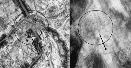
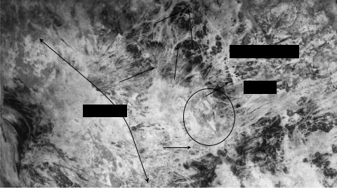
Southeast of ES34, beside the fragments of older sediments, lies ES156, a city that appears to have prospered during the early third millennium (Figure 1.6a). On the mound itself, surface survey turned up Jemdet Nasr–Early Dynastic material, while surrounding lands were littered with flint sickles, once presumed to have been used for grain harvesting. Yet the configuration of this city’s hinterlands does not suggest anything like the regularity of plowed fields, nor communities dependent upon irrigated cultivation. Rather, the surrounding geography suggests the former marshy basin setting of Turaba–Abu Dakar in the al-Khuraib (East Tigris) marshes, with water that floods over and seeps through weak levees, slowly draining southward to eventually rejoin the fluvial system (Figure 1.6c). Closer views bolster this impression of former dendritic water channels infilled with dry sand (Figure 1.6b). At very high resolution, it suggests waterways connecting marshland towns to the clusters of houses and byres built by wetland cattle-keepers who harvest thousands of tons of reeds and rushes for mat-weaving, fodder, fuel, and construction material to meet both local need, and those of urban brokers on the marsh fringes (Figure 1.6d, e) (Salim 1962; Westphal-Hellbusch and Westphal 1962). No excavations have been conducted here, but at nearby Sakheri Sughir, Phragmites phytoliths have been recovered from contexts suggesting the use of this reed as livestock fodder during the Early Dynastic I period (Miller-Rosen and Weiner, 1994; Miller-Rosen 1995 and personal communication
2003, 2011).
Within the “heartland” north of Uruk, throughout the Early Dynastic, average aggregate site area increased, even as the number of settlements fell. This trend toward fewer, but bigger, settlements is explainable not only as a phenomenon of population being drawn in from immediately surrounding, drying wetlands, but as the visible part of the ongoing deltaic progradation cycle. Beyond the eastern limits of the survey area,
Relict channels
ES 156
Old levee
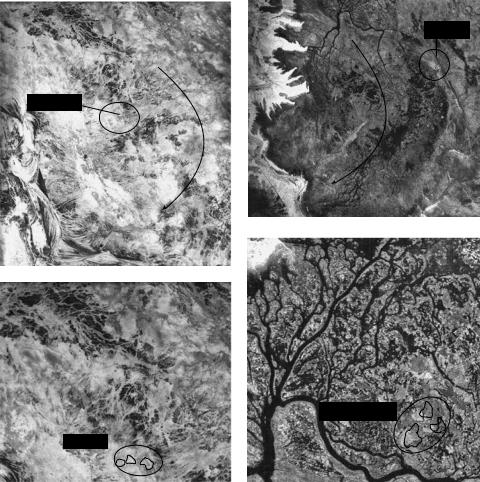
Figure 1.6 (a) Hundreds of thread-like channels, 1.5–10 meters wide, extend between ES156 and surrounding desiccated wetlands, suggesting levee cultivation combined with intensive marshland exploitation.
24
–– Physical geography ––
early sites become nearly invisible, buried beneath the unsurveyed sediments along the Shatt al-Gharraf. What few are recorded suggest that this delta-following settlement process, with concomitant consolidation of urban centers behind the advancing band of smaller settlements, continues forward (Figure 1.4d). The advancing sediment lobe was bounded by what would in Old Babylonian times become a canal, following a sweeping arc from Bad Tibira to Larsa (Steinkeller 2001). At this earlier time, it would have facilitated boat traffic passing from settlement to settlement across the edge of the marshy zone. Later, once the climate dried, the sea level dropped, and the delta protruded further into the estuary zone, waterways extending southeastward maintained connections back to the urban core. As smaller settlements shifted southeastward, out
Turaba
ES 156
Albu Tanam
ES 156
Figure 1.6 (continued) (b) ES156 in the Eridu Basin. (c) Abu Dakar in the al-Khuraib (Tigris) marshes south of Amara. Water overtops banks and leaks through weak levees, eventually rejoining the fluvial system (arrows). (d) Desiccated water channels (white) infilled with dry sand skirt EP156. (e) Dendritic water channels (black) through reed beds skirt Abu Tanam. CORONA May 1968.
25
–– Jennifer R. Pournelle ––
of the surveyed area, following the littoral zone, the integrated centers remained behind and grew, supplied by a forward-expanding hinterland. This model is consistent with calculations that show high rates of settlement founding and abandonment in the Uruk region for the Late Uruk, Jemdet Nasr, and Early Dynastic I periods (Pollack 1999: 73, Table 3.2).
East of the Warka survey area, an ancient levee, cut by modern canals, extends into a flooded marsh. To its south, each year Tell al-Hiba – ancient Lagash – becomes a seasonal island surmounted by multiple occupation mounds. Scattered with kiln debris are small rises on the western margins of “a large, roughly semicircular area that has the appearance of a dry lake bed . . . flooded at various times in the past by the marsh, and as a result covered with a thick layer of dried mud that buried most of the artifacts” (Carter 1990: 61). A deep sounding through this rise, much disturbed by later cuts and pits, found 7 meters of Early Dynastic I trash above the (obviously high) water table (Hansen 1978: 76). Later surface survey turned up a few upcast Uruk sherds, indicating the possibility of earlier occupation (Carter 1990: 61), but the lack of significant quantities of surface material older than late fourth millennium is consistent with a mid-Holocene marine transgression that either precluded permanent habitation altogether, or confined it to relatively small areas, not subject to seasonal inundation, now deeply buried beneath subsequent debris. Even
the extent of the Early Dynastic city is difficult to estimate. No city wall has been discovered, and a significant portion of the ancient ruins lie below the reed-covered marshlands that surround the site on three sides. The central area of the site extended west . . . but it is now covered by the marsh. One mound, now cut off from the rest of the site by water, was found to be covered with sherds of Early Dynastic date. Through most of its history, and particularly in the Early Dynastic period, Lagash, al-Hiba, had a flourishing ceramic industry. This was perhaps due to the proximity of fuel from the marshes.
(Carter 1990: 62)
During the historical Early Dynastic III period (2600–2350 BC), at the height of Lagash’s power, sea levels once again rose to one meter above present (Bird et al. 2010s; Sanlaville 1989, 2003; Potts 1997: 33). Scattered beach rock indicates proximity of a shoreline (Hritz, Pournelle, and Smith 2012b). Faunal remains included not only several species of mollusk shell used in jewelry manufacture, but also two of marine fish, as well as edible conches and bivalves, and six types of waterfowl including duck, flamingo, gull, coot, cormorant, and spoonbill – the latter three particularly preferring open marshes, shallow lagoons, and estuarine mud flats (Carter 1990; Kenoyer 1990: 67; Mudar 1982: 29–30, 33–34). Later third–second millennium BC (land) itineraries from Sumer to Susa run first northwest to the Diyala region, then southeast to their destination, suggesting a requirement to circumvent a marine incursion (Leemans 1960).
Among deltaic cities, Lagash – although probably well above the mean – was hardly unique in its littoral reliance. Among other finds indicating its importance as a port, cylinder sealings from the ED I Seal Impression Strata at Ur depict reed structures (Amiet 1980 [1961]: 333–344), cattle fed in and lead from reed byres (ibid.: 337, 342, 344); personages poled along fish-filled watercourses in high-prowed boats (ibid.: 300), fishing from small watercraft (ibid.: 310), and persons carrying tribute of fish and
26
–– Physical geography ––
waterfowl (ibid.: 302, 303). ED III texts found in Girsu of the é-mi household, headed by the wife of the ruler of the state of Lagash, detail produce from a number of dependent laborers, including fishermen. Renamed the é-Bau under Urukagina of Lagash, of the approximately 1,200 members of the productive household, 100 were listed as fishermen, and another 125 as oarsmen, pilots, longshoremen, and sailors (Maekawa 1974; Van De Mieroop 1987). Economic activities included freshand saltwater fishing, and fish and dried fish brought into the household were both deposited in the store-room and issued as purchase goods to merchants acting on behalf of the household (Postgate 1994: 114, 202).
This accumulated evidence suggests that, while palm groves, gardens, temples, kilns, and other institutions were consolidated on turtlebacks and levees away from seasonal inundation (by peoples well accustomed to thorough exploitation of wetlands), concomitant with intensified agricultural production, reed and other marsh products were also intensively harvested to underwrite urbanizing consumption. The multiple canal off-takes cutting through the relict levee abutting site ES156 clearly directed water flow into the alluvial basin adjacent to the site – but not into any apparent field irrigation system. Instead, the water flow seems designed to augment catchment into what is now a desiccated wetland. The surface morphology of the area is directly comparable to desiccated habitation areas on the seasonally inundated edges of massive, permanent marsh reed beds such as those of the al-Khuraib marsh south of Amara (Figure 1.6).
Separating the twins: UR III and beyond
By painstakingly reconstructing late third millennium BC travel and shipping itineraries from the city of Umma, Piotr Steinkeller has shown that a watercourse thought by textual scholars to represent “the eastern branch of the Euphrates” (Jacobsen 1960) was known at Umma as the Tigris (Idigna) – but the major channels of the twin rivers still flowed so closely together that direct interconnection was maintained, possibly just south of Mashkan-shapir (Steinkeller 2001).7 At Umma itself, texts show clearly the continuing importance of marshland resources like reeds (Steinkeller 1987), fish (Englund 1990), fowl, pigs, and even trees (Heimpel 2011). They also record quotas for production of marsh-based products like reed, bitumen, boats, mats, and standardized fish baskets (de Genouillac 1920: 603–606). However, upstream, the primacy of Isin, Kish, and Babylon during the early to mid-second millennium BC demarcates progressive westward (Euphrates) and eastward (Tigris) channel succession. As the climate dried and became more seasonalized, that succession privileged the (to those cities, proximate) Euphrates as a source of irrigation water, fostering the pearls-strung- through-the-desert view handed down through later historical periods (Figure 1.7a).
CONCLUSION
A hallmark of nineteenth-century beliefs about non-urban landscapes was that marshes are inherently diseased, sodden wastelands, and that the appropriate effort of good government was to transform them into cultivated agricultural land. This emphasis on the importance of transforming “waste” marshes for “useful” agricultural endeavor was especially operative during the formative period of Mesopotamian archaeology.
27
–– Jennifer R. Pournelle ––
MARSHES
GULF
Figure 1.7 The Mesopotamian Delta.
(a) Ur III. (b) 1972. (c) 2010.
MARSH REMNANTS
Through the mid-twentieth century, it was embedded in an outlook that viewed the birth of Mesopotamian civilization as inherently tied to the drying of primordial lands, accompanied by state (or temple, or household) administration of irrigation systems and plow agriculture. In Iraq, in the closing decade of the twentieth century, that belief played a major part in the destruction of nearly 20,000 km2 of wetlands that for centuries prior had directly sustained between a quarterand half-million people (and indirectly many times that number) – in exchange for a few poor years of agricultural output, now abandoned (IMOS 2006; Chen et al. 2010; Garstecki and Amr 2011) (Figure 1.7b and c).
However, as we see in this brief review, we cannot extrapolate the origins of Sumerian urban centers from an irrigated version of the modern desert landscape. Marshy deposits underlay or surrounded the earliest occupation layers of all early urban sites. Those cities are better imagined as islands embedded in a marshy plain, situated on the borders and in the heart of vast deltaic marshlands (Figure 1.5). Their waterways served less as irrigation canals than as transport routes. The essential nature of those wetlands in supporting and shaping the complex social institutions that underlay urbanization in southern Mesopotamia is evident from the earliest protoliterate accounts. For example, the predominance of reeds, reed bundles, and reed structures
28
–– Physical geography ––
points to their significance to early Sumerian economies. Indeed, it may well yet be shown that reeds themselves had lasting importance, not only as a commodity per se, but also in the ways the demands of their production structured urban-centered labor control over their marshland hinterlands.
Thus, the image of urban beads strung along life-giving filaments of rivers and irrigation canals came later. The millennial-scale stability of the earliest centers was contingent upon the vicissitudes of human interaction with natural processes of deltaic progradation. The inner delta in which those cities first formed and grew moved on southeastward, following the drop in sea level (Figure 1.4). Collectively, urban residents had few choices. They could find new settlements, further afield, to extract wetland resources; they could invest in ever-more-extensive irrigation systems, in order to emulate that inate wetland productivity; or they could simply move on. It is a set of choices, and a set of processes, that endures to the present day.
NOTES
1See Verhoeven 1998: 175 (fig. 3) on the interaction of sediment load with stream power, flow velocity, and gradient to determine channel pattern and stability.
2Discussed in detail in Wilkinson, 2003, Chapter 5. See especially Figure 5.7.
3Adams’ original periodized maps must, therefore, be used with caution and detailed attention to the accompanying text. It is not always clear which lines are hypothetical, which observed on air photos, which observed on the ground and presumed associated with nearby sites, and which actually tested for association.
4WS: Warka Survey (Adams and Nissen 1972); NS: Nippur Survey (Adams 1981); ES: Eridu Survey (Wright 1981).
5Crucial to its dating is determining if and when it supplied water to the “northeast–southwest canal” through the city (Finkbeiner 1991: table 19), or to Uruk-period brick canals excavated in the Eanna precinct (Hemker 1993 I: 39–42; II: 138–146). That it is of at least second millennium BC date is suggested by Ur III itineraries linking Uruk to Shurrupak (Steinkeller 2001).
6The riparian regime appears to have been relatively stable until at least the late third millennium
BC, when the Euphrates bed appears to have flipped into the channel skirting the Eridu depression (Figure 1.4d). This channel, as well as the immense overburden of the Ur levee, could well obscure older sites.
7Stone (2002) critiques details of Steinkeller (2001), but agrees that the “Eastern Euphrates” attested in third millennium BC texts was in fact a Tigris distributary.
REFERENCES
Adams, Robert McC. 1965. Land behind Baghdad: A history of settlement on the Diyala plains. Chicago: University of Chicago Press.
——1969. The Evolution of Urban Society. Chicago and New York: Aldine.
——1981. Heartland of Cities: Surveys of ancient settlement and land use on the central floodplain of the Euphrates. Chicago and London: University of Chicago Press.
Adams, Robert McC. and Hans J. Nissen. 1972. The Uruk Countryside: The natural setting of urban societies. Chicago and London: University of Chicago Press.
Al-Dabi, H., M. Koch, M. Al-Sarawi, and F. El-Baz. 1997. Evolution of sand dune patterns in space and time in north-western Kuwait using Landsat images. Journal of Arid Environments 36: 15–24.
Amiet, P. 1980 (1961). La glyptique mésopotamienne archaïque. Paris: Editions du CNRS.
Aqrawi, A.A.M. 1995. Correction of Holocene sedimentation rates for mechanical compaction: the Tigris-Euphrates delta, lower Mesopotamia. Marine and Petroleum Geology 12 (4): 409–416.
29
–– Jennifer R. Pournelle ––
Aqrawi, Adnan A. M. 2001. Stratigraphic signatures of climatic change during the Holocene evolution of the Tigris-Euphrates delta, lower Mesopotamia. Global and Planetary Change
28(1–4): 267–283.
Aqrawi, Adnan A.M., and G. Evans, 1994. Sedimentation in the lakes and marshes (Awhar) of the Tigris-Euphrates delta, southern Mesopotamia. Sedimentology 41: 755–776.
Aqrawi, Adnan A.M., J. Domas, and S. Z. Jassim. 2006. Quaternary deposits. In Geology of Iraq, eds. Saad Z. Jassim and Jeremy C. Goff, pp. 185–196. Prague: Dolin.
Baeteman, C., L. Dupin, and V. Heyvaert. 2004/2005. Geo-environmental investigation. In The Persian Gulf Shorelines and the Karkheh, Karun, and Jarrahi Rivers: A Geo-Archaeological Approach. A Joint Belgo-Iranian Project. First Progress Report, ed. H. Gasche. Akkadica 125(2) : 141–215.
Baker, Victor R. 1986. “Fluvial landforms”. In Geomorphology from Space: A global overview of regional landforms (NASA-SP 486), eds. Nicholas M. Short and Robert W. Blair, pp. 255–315. Washington, DC: National Aeronautics and Space Administration Scientific and Technical Branch. http://www.oercommons.org/courses/geomorphology-from-space-a-global-overview-of- regional-landforms/view (2 February 2012).
Belsky, Joy. 1999. Survey of livestock influences on stream and riparian ecosystems in the western United States. Journal of Soil and Water Conservation 54: 419–431.
Bird, Michael, William Austin, Christopher Wurster, Keith Fifield, Meryem Mojtahid, and Chris Sargeant. 2010. Punctuated eustatic sea-level rise in the early mid-Holocene. Geology 38(9):
803–806. doi: 10.1130/G31066.1.
Boehmer, Rainer Michael. 1999. Uruk: früheste Siegelabrollungen. Mainz: Phillipp von Zabern. Brückner, Helmuth. 2003. Uruk – A geographic and Paleo-archaeologic perspective on a famous
ancient city in Iraq. Geo-Öko XXIV: 229–248. Bensheim: Georg-August University.
Buday, Tibor and Saad Z. Jassim. 1987. The Regional Geology of Iraq: Tectonism, magmatism, and metamorphism. Baghdad: Government of Iraq, Geological Survey and Mineral State Establishment.
Buringh, P. 1960. Soils and Soil Conditions in Iraq. Baghdad: Ministry of Agriculture Directorate General of Agricultural Research and Projects.
Carter, Elizabeth. 1990. A surface survey of Lagash, al-Hiba, 1984. Sumer 46: 60–63.
Chen, Z.M., Kavvas, N. Ohara, M. Anderson, and J. Yoon, 2010. Impact of water resources utilization on the hydrology of Mesopotamian marshlands. Journal of Hydrologic Engineering 16, speical issue: 1083–1092. [doi:10.1061/(ASCE)HE.1943–5584.0000208.
Cole, S.W., and H. Gasche. 1998. Second-and first-millennium BC rivers in Northern Babylonia. In
Mesopotamian History and Environment 5/1 – Changing Watercourses in Babylonia: Towards a Reconstruction of the Ancient Environment in Lower Mesopotamia, eds. H. Gasche and M. Tanret, pp. 1–64. Ghent: University of Ghent.
Englund, Robert K. 1990. Organization und Verwaltung der Ur-III Fischerei. Berlin: Berliner Beiträge zum vorderen Orient 10.
—— 1998. Texts from the late Uruk period. In Späturuk-Zeit und Frühdynastische Zeit, eds. Pascal Attinger and Marcus Wäfler. Freiburg and Göttingen: Universitätsverlag and Vandenhoeck & Ruprecht.
Garstecki, T. and Z. Amr. 2011. Biodiversity and Ecosystem Management in the Iraqi Marshlands – Screening Study on Potential World Heritage Nomination. Amman, Jordan: IUCN.
Gasche, Hermann and M. Tanret (eds.). 1998. Changing Watercourses in Babylonia. Towards a reconstruction of the ancient environment in lower Mesopotamia. Ghent and Chicago: University of Ghent and the University of Chicago Oriental Institute.
Gibson, McGuire. 1972. The City and Area of Kish. Miami: Field Research Publications. Genouillac, Henri de. 1920. Texte cunéiform de Louvre. Paris: Leroux.
Finkbeiner, U. 1991. Uruk Kampagne 35–37 1982–84: Die archäologische Oberflächenuntersuchung (Survey). German Archaeological Institute, Baghdad Division. Ausgraben in Uruk-Warka Endberichte, vol. 4, ed. Rainer Michael Boehmer. Mainz: Verlag Philipp von Zabern.
Hansen, Donald P., Al-Hiba 1978. A summary of four seasons of excavation: 1968–1976, Sumer, vol.
34, pp. 72–85.
30
–– Physical geography ––
Heimpel, Wolfgang. 2011. Twenty Eight Trees Growing in Sumer. In Garˇsana Studies, Cornell University Studies in Assyriology and Sumerology 6, ed. David I. Owen, pp153–159. Bethesda: CDL Press.
Hemker, C. 1993. Altorientalische Kanalisation: Untersuchungen zu Beund Entwässerungsanlagen im mesopotamisch–syrisch–anatolischen Raum. 1. Text. 2. Abbildungen. Abhandlungen der deutschen Orient Gesellschaft 22. Munster: Agenda Verlag.
Heyvaert, Vanessa and Cecile Baeteman. 2008. A Middle to Late Holocene avulsion history of the Euphrates River: a case study from Tell ed-Der, Iraq, Lower Mesopotamia. Quaternary Science Reviews 27: 2401–2410. doi : 10.1016/j.quascirev.2008.08.024.
Hritz, Carrie. 2010. Tracing settlement pattern and channel systems in Southern Mesopotamia using remote sensing. Journal of Field Archaeology 35 (2); 184–203.
Hritz, Carrie and J.R. Pournelle. In press. 2012. Feeding history: deltaic resilience, inherited practice, and millennial-scale sustainability in an urbanized landscape. In From Field to Table: Historical Ecology of Regional Subsistence Strategies, ed. David Goldstein, pp. . . . . Columbia, SC: University of South Carolina Press.
Hritz, C., J.R. Pournelle, and J. Smith. In press (2012a). Mid-Holocene Dates for Organic-Rich Sediment, Palustrine Shell, and Charcoal, Southern Iraq. Radiocarbon 54 (1).
——. In press (2012b). Revisiting the Sealands: Report of Preliminary Ground Reconnaissance in the Hammar District, Dhi Qar and Basra Governorates, Iraq. Iraq 74.
Huot, Jean-Louis, Yves Calvet, J. Chevalier, and Jean-Daniel Forest. 1981. II. Tell el ’Oueili. Rapport préliminaire sur la deuxième campagne, (1978). Syria 58 (1–2): 101–120. doi : 10.3406/ syria.1981.8590.
IMOS, 2006. Iraqi Marshlands Observation System – UNEP Technical Report 2006. http://post conflict.unep.ch/publications/UNEP_IMOS.pdf.
Jacobsen, Thorkild. 1958. La géographie et les voies de communication du pays de Sumer. Revue d’Assyriologie 52: 127–129.
—— 1960. The waters of Ur. Iraq 22: 174–185.
Kenoyer, Jonathon M. 1990. Shell artifacts from Lagash, al-Hiba. Sumer 46: 64–66.
Leemans, W.F. 1960. Foreign Trade in the Old Babylonian Period as Revealed by Texts from Southern Mesopotamia. Leiden: Studia et documenta ad iura orientis antique pertinenta VI.
Maekawa, Kazuya. 1974. The development of the é-mi of Lagash during the Early Dynastic III.
Mesopotamia 8–9: 77–144.
Mashkour, Marjan, Andrew Bauer, Tony Wilkinson, Nicholas Kouchoukos, and Abbas Alizadeh. 2004. Human-Environment Interactions on the Upper Khuzestan Plains, Southwest Iran. Recent Investigations. Paléorient, 30 (1): 69–88. doi: 10.3406/paleo.2004.4773.
Miller-Rosen, Arlene. 1995. Analytical techniques in Near-Eastern archaeology, phytolith analysis.
Biblical Archaeologist 58 (3): 170.
Miller-Rosen, Arlene and S. Weiner. 1994. Identifying ancient irrigation – a new method using opaline phytoliths from emmer wheat. Journal of Archaeological Science 21 (1): 125–132.
Mudar, Karen. 1982. Early Dynastic III animal utilization in Lagash: a report on the fauna of Tell al-Hiba. Journal of Near Eastern Studies 41: 23–63.
Northedge, Alastair, T.J. Wilkinson, and Robin Falkner. 1989. Survey and excavations at Samarra.
Iraq 52: 75–84.
Nützel, Werner. 1978. To which depths are the “prehistorical civilizations” to be found beneath the present alluvial plains of Mesopotamia: A theoretical archaeology contribution. Sumer 34: 17–26.
Oates, Joan L. 1960. Ur and Eridu, the prehistory. Iraq 22: 32–50.
Plaziat, J.C. and P. Sanlaville. 1991. Donnes Récentes sur la sédimentation tardive dans la plaine de Larsa-Ouelli. In ‘Oueilli: Travaux de 1985, ed. J.-L. Hout pp. 342–343. Paris: Editions Recherche sur les Civilizations.
Pollack, Susan. 1999. Ancient Mesopotamia. Cambridge: Cambridge University Press.
Postgate, J.N. 1994. Early Mesopotamia: Society and economy at the dawn of history. London and New York: Routledge.
31
–– Jennifer R. Pournelle ––
Potts, Daniel T. 1997. Mesopotamian Civilization: The material foundations. Ithaca: Cornell University Press.
Pournelle, J.R. 2003a. The littoral foundations of the Uruk state: Using satellite photography toward a new understanding of 5th/4th millennium BCE landscapes in the Warka survey area, Iraq. In
Chalcolithic and early Bronze Age hydrostrategies, ed. Dragos Gheorghiu, pp. 5–23. B.A.R. International Series 1123. Oxford: Archaeopress.
——2003b. Marshland of Cities: Deltaic landscapes and the evolution of early Mesopotamian civilization. Ph.D. dissertation, Department of Anthropology, University of California, San Diego. http://sc.academia.edu/JenniferPournelle/Papers/872585/Marshland_of_Cities_Deltaic_ Landscapes_and_the_Evolution_of_Early_Mesopotamian_Civilization.
——2007. KLM to Corona: a bird’s-eye view of cultural ecology and early Mesopotamian civilization. In Settlement and Society: Essays dedicated to Robert McCormick Adams, ed. E. Stone, pp. 29–62. Los Angeles: UCLA Cotsen Institute of Archaeology, and Chicago: Oriental Institute.
Pournelle, J.R. and G. Algaze. In press (2012). Travels in Edin: Deltaic resilience and early urbanism in greater Mesopotamia. In Preludes to Urbanism: Studies in the late chalcolithic of Mesopotamia in honour of Joan Oates, eds. H. Crawford, A. McMahon, and N. Postgate. B.A.R. International Series. Oxford: Archeopress.
Safar, F., M.A. Mustafa, and S. Lloyd. 1981. Eridu. Baghdad: Ministry of Culture and Information, State Organization of Antiquities and Heritage.
Salim, S.M. 1962. Marsh Dwellers of the Euphrates Delta. London School of Economics Monographs on Social Anthropology. London: Athlone.
Sanlaville, Paul. 1989. Considérations sur l’évolution de la Basse Mésopotamie au cours des derniers millenaires. Paléorient 15 (2): 5–27.
——2003. The deltaic complex of the lower Mesopotamian plain and its evolution through millennia. In The Iraqi Marshlands, eds. Emma Nicholson and Peter Clark, pp. 133–150. London: Politicos Publishing.
Schumm, S.A. and H.R. Khan. 1972. Experimental study of channel patterns. Geological Society of America Bulletin 83: 1755–1770.
Steinkeller, Piotr. 1987. The foresters of Umma: Toward a definition of Ur III Labor. American Oriental Society 68: 73–115.
—— 2001. New light on the hydrology and topography of southern Babylonia in the third millennium. Zeitschrift für Assyriologie 91: 22–84.
Stone, Elizabeth. 2002. Whither the Tigris? Abstracts of the 103rd Annual Meeting of the Archaeological Institute of America 25: 58.
Van De Mieroop, M. 1987. Women in the economy of ancient Sumer. In Women’s Earliest Records from Ancient Egypt and Western Asia, ed. Barbara Lesko, pp. 53–46. Atlanta: Scholars Press.
Verhoeven, K. 1998. Geomorphological research in the Mesopotamian flood plain. In Changing Watercourses in Babylonia. Towards a reconstruction of the ancient environment in Lower Mesopotamia, eds. Hermann Gasche and M. Tanret, pp. 159–245. Ghent and Chicago: University of Ghent and the University of Chicago Oriental Institute.
Westphal-Hellbusch, Sigrid, and Heinz Westphal. 1962. Die Ma’dan. Kulture und Geschichte der Marschenbewohner in Sud-Iraq. Berlin: Duncker und Humbolt.
Wilkinson, Tony J. 1990. Early channels and landscape development at Abu Salabikh; a preliminary report. Iraq 52: 75–84.
—— 2003. Archaeological landscapes of the Near East. Tucson: University of Arizona Press.
Wirth, Eugen. 1962. Agrargeographie des Irak. Hamburger geographische Studien 13. Hamburg: Institut für Geographie und Wirtschaftsgeographie der Universität Hamburg; Cram de Gruyter & Co.
Wright, Henry T. 1981. The southern margins of Sumer: Archaeological survey of the area of Eridu and Ur. In Heartland of Cities: Surveys of ancient settlement and land use on the central floodplain of the Euphrates, ed. Robert McC. Adams, pp. 295–338. Chicago and London: University of Chicago Press.
32
CHAPTER TWO
HYDRAULIC LANDSCAPES AND
IRRIGATION SYSTEMS OF SUMER
Tony J. Wilkinson
It is often implied that Sumer derived much of its economic strength from irrigation, but in reality water provided an even more fundamental context for everyday life.
This is because water manifested itself in many ways: not only as a supplier of essential drinking water for humans and their flocks, but also in the form of marshes and wetlands, as irrigation water, and as rivers and channels for bulk transport. The Tigris and Euphrates rivers not only nurtured major economic resources in the form of fish, reeds, and other wetland products, but were also regarded as sacred rivers (Wood 2005). Consequently, rather than simply discussing irrigation, this chapter tackles the overall ‘hydraulic landscape’.
Some cuneiform texts emphasise the role of water as the provider of abundance (Winter 2007: 136). For example, a ‘hymn’ of the Ur III or Old Babylonian periods (referred to as Ur-Nammu D) describes the king as having been provided with broad wisdoms by Enki, digging a ‘canal of abundance’ in his home city of Ur, which then produced plentiful fish, birds, and plants, as well as watering large tracts of arable land where barley ‘sprouts like reed thickets’ (Winter, 2007: 136; Flückiger-Hawker 1999: D21–22, 33–36). By the late third millennium BC, much of the available water of southern Mesopotamia was used for the irrigation of grain crops and the province of Lagash became a major centre of grain production, much of which was delivered to redistribution centres in the form of bala tax (Rost 2010: 8). In terms of landscape development, this is difficult to imagine because in the mid-twentieth century AD the city mound of al-Hiba/Lagash was surrounded by marshes (Cotha Consulting 1959a: maps).
Ultimately, the maximum amount of land that could be irrigated in Mesopotamia was limited by the overall discharge of water in the Euphrates and Tigris rivers, specifically during the period of low flow during the autumn and early winter. Although estimates of the total area of potential cultivation in the Mesopotamian lowlands range from 8,000 to 12,000 sq km (Adams 1981: 5–6), if the Euphrates alone is employed, to as high as 30,000 sq km (Ionides 1937), it is evident that the irrigated area was but a fraction of the total potential cultivable area, especially when the often large amount of fallow and wasteland is taken into account (Adams 1981; Gibson 1972).
Water has a range of practical roles or functions and in southern Mesopotamia these can be summarised as follows (Hunt 1988: 189–190):
33
–– Tony J. Wilkinson ––
•Irrigated agriculture
•Transportation
•Drinking water
•Waste removal
•Water for manufacturing.
These functions were serviced by a complex array of natural and artificial flows and hydraulic installations some of which are recorded in texts and in the landscape, others of which must be inferred.
SOURCE OF INFORMATION
The source material for the Sumerian hydraulic landscape is substantial, but because these sources are very uneven, they need to be interpreted with care. Consequently, it is difficult to make a realistic reconstruction of the landscape of irrigation without making a number of educated guesses or by employing ethnographic data to flesh out the record and aid interpretation. Although there are evident differences between the ancient and modern landscapes of modern Iraq, it is necessary to have a general understanding of how the contemporary communities manipulated water and how the soils were harnessed, and discussions of traditional Mesopotamian irrigation are provided by Charles (1988, 1990), Pemberton et al. (1988), Postgate (1990), Poyck (1962) and Fernea (1970).
Much basic information on irrigation terminology and labour organisation derives from cuneiform administrative, mathematical and literary texts. Particularly engaging are the mathematical texts which provide problems to be solved along the lines of: a cistern was defined as of given dimensions and depth, therefore how much land could a depth of X irrigate (Powell 1988: 162)? Of course, because these exercises were not necessarily designed to be used for real-life situations, Powell regards these simply as a ‘paradigm for calculation’. Nevertheless, they provide valuable insights into the excavation of canals, the types of excavation that took place (such as ‘throw-out work’ and ‘basket work’) as well as information on features such as dams and barrages and a wide range of lists of terms used (Powell 1988: 164, 166, 169–170).
Similarly, administrative texts provide valuable information on the role of irrigation in agriculture, and especially useful is the so-called Georgica or ‘Farmers’ Instructions’ (Civil 1994: 134). Unfortunately, such texts were often rather partial in the amount of information they conveyed and many were simply intended to calculate the costs of labour, earth moving and related activities. Usually the scribes of the Ur III period preferred to focus upon the amounts of earth extracted and piled up rather than on the cross-sections of the water courses themselves, because such volumes are more amenable to computation (Civil 1994: 135). Nevertheless, these mundane administrative concerns with earth moving find significant parallels in the landscape where visible features such as mounds of up-cast sediment are particularly conspicuous. Such mounds can sometimes be more conspicuous than ‘negative features’ dug into the ground.
Overall, there is a lack of reference to officials or offices related to water management (Rost 2010: 14) as well as a dearth of irrigation accounts or calendars. This situation contrasts with, for example, the qanat/falaj books that detail the allocation of irrigation water in, for example, post-medieval Oman (Wilkinson, J.C. 1977).
34
–– Hydraulic landscapes and irrigation systems ––
More subversively, administrative texts, being derived from state archives, tend to support centralised models of irrigation management such as that of Wittfogel (1957). In other words, because they only seem to refer to that part of the system that needed to be recorded for the purposes of the state, cuneiform records cannot therefore be regarded as providing a picture of the operation of the entire irrigation system (Rost
2010: 2).
Within Mesopotamia there is, unfortunately, a dearth of detailed archaeological data on the size and layout of Sumerian irrigation systems as well as for actual water control features. Nevertheless, in addition to texts, the landscape itself provides information on ancient irrigation, including the canals themselves, alignments of ancient sites along former channels, and less frequently, evidence of field systems (Wilkinson, T.J. 2003: 45–46, fig. 5.7). Techniques employed to record such traces include satellite imagery and air photographs (Hritz 2010), detailed contour maps that distinguish ancient levees (Coles and Gasche 1998), digital terrain models (Hritz and Wilkinson 2006) and auger investigations that provide cross-sections of alluvial sediments (Verhoeven 1998). In addition, a wealth of information occurs in consultants’ reports, usually made for twentieth-century agricultural development projects. Charred plant remains recovered from excavated archaeological layers are particularly useful because they supply information on irrigated crops, weeds of cultivation, as well as on the relative abundance of water (Neef 1989).
Unfortunately, it is not always easy to link the above classes of information together. For example, although administrative texts might refer to a canal, it is not always easy to know which of a ganglion of canals on a satellite image might refer to the feature discussed in a particular cuneiform tablet. Whereas archaeobotanical remains can be dated by radiocarbon methods, it will not be clear where they were originally cultivated; on the other hand, canals and relict channels, although they can be accurately located within the landscape, are often difficult to date. A particularly serious problem with the evidence from field archaeology is that much Mesopotamian archaeology was conducted before palaeobotanical and landscape analysis became commonplace techniques, and because at the time of writing, it continues to be difficult to gain secure safe access to Mesopotamia, it is difficult to undertake the appropriate ‘ground control’. Nevertheless, judicious use of the range of sources discussed above makes it possible to attempt plausible reconstructions of ancient irrigation systems.
PHYSICAL CONTEXT OF THE HYDRAULIC LANDSCAPE
Sumer developed within an alluvial depression sandwiched between the Zagros Mountains to the east and the western desert of Iraq to the west (Pournelle this volume). The alluvium of this sedimentary basin has been deposited by the combined waters of the Tigris and Euphrates, as well as in the form of marine deposits within the head of the Persian Gulf, which at around 4000 BC extended some 200–250 km inland of the present coastline near Fao (Ur this volume: fig. 7.1).
The southern part of the Mesopotamian plains that make up the land of Sumer have been subdivided into four broad soil zones (Buringh 1960: 121):
•The floodplain of the Tigris and Euphrates rivers where the sinuous or anastomosing rivers usually flow on low levees with levee slopes ideal for gravity flow
35
–– Tony J. Wilkinson ––
process has not escaped the attention of cuneiform scholars and Edzard, drawing on historical records that described a catastrophic shift in the bed of the Euphrates near Mussaiyib in AD 1820, has suggested that similar shifts could have dispersed those ancient populations whom the Old Babylonian kings say they returned to their settlements (Edzard 1957: 117; also Potts 1997, note 6). Also, a statement by Siniddinam, king of Larsa, (c.1849–1843 BC) may refer to an earlier avulsion:
In order to provide sweet water for the cities of my country . . . [An and Enlil] commissioned me to restore it [to its original bed].
(Frayne 1990: 158–160; Steinkeller 2001)
Wetlands
Although today much of southern Mesopotamia appears to be alluvial desert, arid salt flats and belts of sand dunes, that indispensible guide to twentieth-century Iraq, The Geographical Handbook, states: ‘In striking contrast to conditions on the Syrian desert, the alluvial lands of southern Mesopotamia suffer from a surfeit of water’ (Naval Intelligence Division 1944: 189). In fact, marshes and wetlands were probably much more significant during the Ubaid and the development of early states (Pournelle 2007). That wetlands were important during the period of Eridu is suggested by Wright, who points out that the marshes provided a significant resource for the Ubaid inhabitants (Wright 1981: 323) and Postgate who described the marshes as ‘teeming with life’ (Postgate 1994: 158). The role of wetlands in the development of the prehistoric communities was emphasised by Oates (1960) and more recently by Pournelle who suggests that the earlier phases of Ubaid settlement were closely tied into a wetland environment and many sites occurred on drier ‘turtle backs’ in the form of relict Pleistocene islands (Pournelle 2003, 2007).
Although wetlands evidently formed an important source of resources during the phases of Ubaid settlement, the analysis of charred plant remains from Tell Oueli demonstrate that cereals were also irrigated (Huot 1989: 26; Neef 1989), but it is difficult to say which was more important to the Ubaid economy. However, by the third millennium BC, Sumer had become an important area of cereal production (Winter 2007: 120), and irrigated cultivation probably gained ground over the use of wetlands. This may be because, although marshlands provide a wealth of resources in terms of reeds, building materials, fish and molluscs, their over-exploitation can result in their depletion, whereas irrigation and cereal agriculture enabled the economic base of the growing Sumerian civilisation to be enlarged. This process of ‘positive feedback’ would have enabled the economy to grow further, as discussed below. It is even apparent that during the third millennium BC wetlands were drained, as in the case of the Ur III king Ur-Nammu, who is recorded as draining marshes estimated to cover 1 shargal (SHAR2.GAL, perhaps 233 sq km; Civil 1994: 112).
The flood cycle
Critical to the agricultural economy was the annual flood cycle, which is poorly synchronised with the needs of cultivators. In contrast to the Nile, whose monsoondriven annual flood well matches the needs of irrigation, the annual flood of both the
38
–– Hydraulic landscapes and irrigation systems ––
Tigris and the Euphrates peaks in April and May as a result of winter rainfall and spring snowmelt on the mountains of Anatolia, Iran and Iraq (Adams 1981: 3–6). This not only threatens the ripening grain crops, but also requires that considerable efforts be made to protect the fields from flooding (Hunt 1988: 193). Thus Miguel Civil may be correct to suggest that the Sumerians expended more effort on flood control than in the distribution of water for irrigation (Civil 1994:110):
Most Ur III texts dealing with earth moving refer to the construction of embankments (ég). This is (i)n agreement with the water regime in the area. The need to protect the crops, ready for harvest from the river’s high waters, and to prevent the flooding of towns and fields, is clear in economic and literary texts.
(Civil 1994: 134)
Of the two rivers, the Tigris had both a higher total annual water discharge and a higher flood level, and this combined with the entrenched nature of part of its valley means that it is conventionally regarded as being the more difficult of the two rivers for irrigation.
The mismatch between the annual flood and the eventual development of largescale irrigation is perplexing because it makes it difficult to understand how the early phases of irrigation developed. The Dutch soil scientist Buringh suggests that initial irrigation was a form of flood recession agriculture that took place in the lower flood basins following the retreat of the annual flood waters (Buringh 1960: 152). Although simple irrigation could subsequently have developed out of small natural overflows and levee breaks, which provided the locus for more organised irrigation (Buringh 1960; Wilkinson, T.J. 2003: 89), these could only operate during the spring floods when the water was at its peak, which was not the correct time for the irrigation of cereals. Moreover, by discharging excess water at weak points on the river bank, these crevices could be enlarged by the river thereby encouraging channel breaks and even channel shifts or avulsions. On the other hand, spring and early summer floods would have benefited the palm gardens that require copious water, especially during the hot summer months and which must have been a very important crop during the third millennium BC (Crawford 2004: 52). Because date gardens occupy the levee crests, this cycle of summer irrigation would have been in keeping with the natural ecology of the region. This spring and early summer flood would also have provided the appropriate soil water to initiate cereal crops’ growth in the autumn. As the need for cereals grew during the later stages of the Ubaid and/or the Uruk period, irrigation channels could have been extended down levee to more distant fields that would progressively withdraw more water during the lower phases of the flood cycle. Such an evolutionary model of progressive development away from a riverine belt of palm gardens would fit the model of traditional palm garden agriculture in southeast Arabia where palm garden oases formed the primary focus of cultivation together with lower storeys of plants within the shade. In such cases, only excess flow from the irrigation systems would have been guided to temporary cultivation downstream of the oasis. The leveecrest garden agriculture of southern Mesopotamia would complement the wetland resources to provide the formative stage of Sumerian agriculture.
39
–– Tony J. Wilkinson ––
Salinity
Soil mapping in advance of major irrigation projects has demonstrated that waterlogged so-called hydromorphic soils are particularly common within the floodbasins and lower levee slopes of southern Mesopotamia. These soils tend to become saline when the water table remains close to the ground surface so that osmotic processes cause salts to rise and accumulate near the surface (Buringh 1960). Since Jacobsen and Adams (1958) suggested that a shift towards the more salt tolerant barley was associated with increased salinisation, there has been a vigorous debate concerning the role of salinisation in the demise of Sumerian civilisation. Although this model has been disputed (Powell 1985), there can be little doubt that if irrigation spread down levee towards flood basins, there would have been greater loss of crops due to salinisation. However, as discussed below, because cereal cultivation may have been mainly confined to the levee slopes during the third and even the early second millennium BC, the worst affects of salinisation may have been avoided.
BROAD PATTERNS OF WATER DISTRIBUTION
Whereas the conventional model suggests that the lion’s share of irrigation water during the third millennium BC derived from the more readily controlled and less incised Euphrates River (Jacobsen 1960), it has been argued that the Tigris also played a role in the supply of water to the lower plains (Potts 1997: 7–10, 26). This debate must be contextualised within the dynamic and branching nature of the Mesopotamian rivers which shifted significantly throughout the Holocene.
During the earlier Holocene a joint Tigris–Euphrates channel is thought to have flowed through the centre of the plain (Paepe 1971), with the two rivers subsequently separating so that the Tigris migrated to the east and the Euphrates to the west (Adams 1981; Algaze 2008, fig. 5; Hritz 2010: 187). After these early and rather obscure phases, the record becomes clearer and ancient levees in the region of Sippar demonstrate that during much of the third and second millennium BC the Mesopotamian plains received a significant amount of water from branches of the Euphrates that radiated out from the region of Sippar and contributed multiple channels that ultimately flowed to the Sumerian cities of the lower plains (Jacobsen 1960; Cole and Gasche 1998). On the other hand, Heimpel (1990: 213) has shown that the watercourse that flowed past Girsu, Umma and Adab was the Tigris or a branch of it. Unfortunately, this reconstruction runs into the problem that east of Sippar in the northern plains levees of branches of the Euphrates extended east as far as the Tigris River and appear to have watered the southern plains (Cole and Gasche 1998: map 5). Alternatively, Hritz shows that a massive levee within the Diyala region may have been an earlier course of the Tigris, which would then have supplied southern Sumer with irrigation water from a northerly direction (Hritz 2010: figs. 13 and 14). This reconstruction also places the Tigris at a level which would have enabled it to supply irrigation water by gravity flow to a much larger area without the need for labour intensive water-lifting devices.
Illustrative of the complexities of these dynamic river systems is that of the water supply of Umma which had two principal watercourses: the Idigna and the Iturungul, both of which were its major lifelines (Adams 2008: 6). Whereas the former was a branch of the ancient Tigris, its clearly canalised offshoot to the south, the Iturungul, ultimately joined a major branch of the ancient Euphrates not far downstream from
40

–– Tony J. Wilkinson ––
Overall, the natural hydraulic landscape of anastomosing rivers and marshes was taken advantage by early communities who probably used levee crests for palm gardens, levee slopes for supplementary cultivation, with wetlands and perhaps tidal areas providing marshland resources alongside flood recession agriculture (Kouchoukos 1998; Pournelle 2007). Gradually, however, this landscape mosaic became more managed so that what had been a ‘natural’ landscape became transformed into a ‘cultural’ landscape with canals and fields becoming more formalized and extensive (Algaze 2008). Nevertheless, ‘natural’ elements presumably persisted but were also managed in order to conserve their valuable resources. This was a landscape mosaic in which rivers, marshes and artificial channels all played a role, and presumably where artificial canals became increasingly significant and elongated by the later third millennium BC.
THE LAYOUT OF CANALS AND WATER SUPPLY
River levees and the framework for Sumerian irrigation
One question raised by the textual evidence is the paucity of records of large canals. Whereas the embankments of smaller canals of 6–9 m2 cross section (Civil 1994: 135) were quite common, administrative records relating to Ur III Umma and Girsu appear silent on the existence of larger canals. Mathematical texts also point to rather short canals by implying that most canals and irrigation ditches (pa5 sig in Sumerian) were mainly 1.8–2.16 km long (Powell 1988: 163). On the other hand, in his royal inscriptions Ur Nammu claims to have authorised the excavation of major works, and records of large canals, such as the 50 km Nina canal, were occasionally recorded (Rost 2010: 16–17).
If canals were constructed to flow down the longitudinal gradient of the plain, due to its very low gradient, it would have been necessary for the head gates of canals to have been up to 40 km upstream from the point where water was distributed for irrigation (Hunt 1988: 201). However, a key advantage of the Mesopotamian landscape is the presence of riverine levees raised 1–3 metres above plain level and which contributed a gradient normal to the main river that was significantly steeper than that of the plain itself. Such levee back-slopes that led away from the stream towards adjoining basins provided natural drainage and were highly suitable for cultivation (Adams 1981: 8).
The significance of gradient is demonstrated by statistics provided in irrigation reports of the Shatt al-Gharraf area (Cotha Consulting) (Table 2.1).
Table 2.1 Range of gradients of floodplain and levee slopes in the Gharraf East Area, near Tello-Girsu
Orientation of gradient |
Mean regional gradient |
Range of gradients |
|
|
|
Longitudinal (over 130 km) |
0.05/1000 (1: 20,000) |
0.04/1000 (1: 25,000) to |
|
|
0.45/1000 (1: 2222) |
Transverse (gradients for main channel levees): |
|
|
Gharraf (1500m) |
2/1000 = 1: 500 |
|
El Amah (1700 m) |
1.4/1000 = 1: 714 |
|
Shattrah (3200 m wide) |
0.8/1000 = 1: 1250 |
|
|
|
|
Note: From Cotha 1959b: 14 Table A. VIII-1.
42
–– Hydraulic landscapes and irrigation systems ––
The communities of Sumer therefore had the choice of digging either long canals up to 40 km (Hunt 1988: 194) with extremely gentle gradients, or rather shorter canals from the rivers down the slope of the levee (Figure 2.4 a and b). The latter have significantly steeper gradients which are more flexible for water distribution to the fields and which are less likely to silt up or be subject to salinisation. Such channels would provide modest-size irrigation modules capable of being organised by kin groups or small-scale communities (Fernea 1970; Rost 2010; Pollock 1999: 31). In fact, many traditional irrigation systems illustrated on maps of the southern Mesopotamian plains adopt this configuration (Figure 2.5). Significantly, short canals of 1.8–2.2 km would correspond roughly to total levee widths of 3.6–4.3 km, figures comparable to the levee widths of 2–5 km estimated by Pournelle (2007). This is also similar to the width of distributions of clay sickles used by Henry Wright to estimate the agricultural belts around Ubaid and Ur in the Ubaid and Uruk periods (Wright 1981: 324).
Overall, it is therefore possible to reconstruct the hydraulic landscape of third–early second millennium BC Sumer as forming three basic zones:
•The levee crest where channels irrigated palm gardens, other orchard crops (some as a storey below the palms), vegetables and grain fields.
•The levee slopes where short canals irrigated fields mainly to grow cereals, perhaps pulses and onions (Hrusˇka 2007: 58). Together, zones one and two probably extended some 2–5 km away from the levee crest or main channel.
•A mosaic of steppe, marshes, fallow and alluvial desert steppe beyond the main levees. Although cultivation could have been extended into this zone, this would result in rapid salinisation. This zone would have supplied grazing, fishing, game birds, reeds and other marshland resources (Pournelle 2007).
There was therefore a choice between either long canals that followed the grade of the plain, but required more labour and were prone to siltation, or shorter steeper canals that serviced a small area, but which were potentially vulnerable to peak floods that could rip through off-takes. Because the levee width would limit the area of cereal production, and territorial boundaries between neighbouring towns and cities would limit the cultivated territories along the river channels, the total productive area would have been constrained. Nevertheless a 5–6 km wide levee with settlements some 10 km apart would have been capable of sustaining towns of up to 8,000–12,000 people, perhaps covering between 40 and 120 ha. During times of social cohesion and political accord between communities, the ease of transport of bulk products by boat would have enabled shortfalls of crop production to be addressed by transporting grain from neighbouring communities (Wilkinson et al. 2007: 188). However, if political relations with city states upstream or downstream soured, the existing site territory may have been insufficient to supply the towns and there would have been a temptation either to violate fallow in order to provide crops every year (Gibson 1974), or to build longer canals, thereby increasing the cultivable area. However, if such canals were extended into the lower flood basins, there would have been the risk of salinisation. In other words, greater political unity would have enabled more boat traffic to take place between communities as was the case in the Ur III period, a period when it was also easier to mobilise grain for the payment of the bala tax (Steinkeller 1987; Algaze 2008: 56–57; Widell 2008).
43
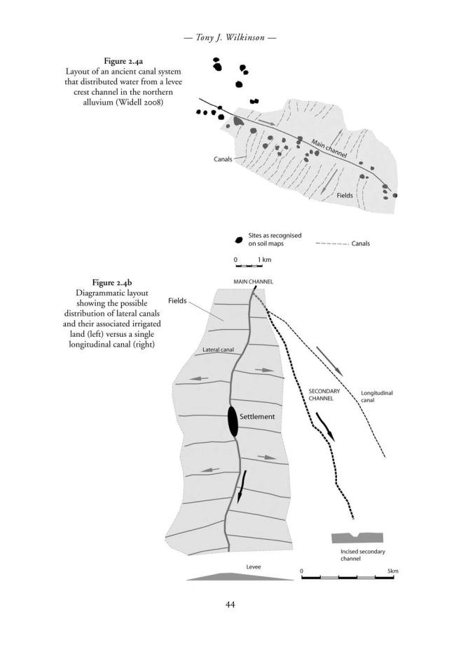

–– Tony J. Wilkinson ––
later. Instead there was a patchwork of urban-centred zones of varying size along connective but often narrow canal or river-branch corridors, and zones of irrigated agriculture, apparently interspersed with marsh and steppe deemed difficult or unsuitable (sometimes too saline) to justify irrigating.
(Adams 2008: 15, 1978)
This differentiated pattern of irrigation also implies that there were limitations to the extent of either provincial or royal authority which may not have spread into the more remote areas of the countryside (Adams 2008: 16).
WATER SUPPLY AND AGRICULTURE
The terminology from mathematical texts, school texts and the ‘Farmers Instructions’, when combined with knowledge of modern irrigation techniques and ethnography, enable plausible reconstructions to be made of ancient hydraulic works (Pemberton et al. 1988; Postgate 1990; Hunt 1988). It is necessary to be wary, however, not only because some features of the Sumerian landscape will have been significantly different from those of the recent past (Zettler 2003), but also because the term ‘water works’ rather than ‘irrigation canals’ may be more appropriate for much of the terminology because many activities were focused on flood control, not just irrigation (Powell 1988: 162; Civil 1994).
Powell (1988) subdivides Sumerian water works into three broad groups:
•Canals and irrigation ditches
•Dams and barrages
•Wells, cisterns and reservoirs.
Channels, canals, banks and irrigation ditches
The term pa4/pa5–(r) refers to an irrigation ditch (Civil 1994: 109), but because the state authorities were more concerned with labour expended on digging canals, the texts refer to the volume of soil up-cast and the size of the resultant levees. Therefore evidence of canals derives mainly from references to the mounds of up-cast alongside (ég), rather than the ditch itself (Civil 1994: 109; Pemberton et al. 1988: 212–213). For example, at Girsu, texts refer to small embankments with cross-sections ranging from 0.5 x 0.5 to 1.25 x 2.5 m (Ibid.: 118), whereas around Umma cross-section areas ranged from 6 x 0.5 m to 9 x 2.5 m (Ibid.: 118). The latter represents a canal of substantial size, especially because there would probably be two banks, one on each side. In addition, those parts of the levees that were vulnerable to erosion or to rising flood waters were reinforced with reeds or rushes (ú-sag11: Ibid.: 121).
Canal construction was often commemorated, and the king Rim-Sin refers to the excavation of the canal known as Simat-Erra as follows: ‘its two embankments/levees are like mountains’. This is an apt description for anyone who has seen the landscape associated with major canals which dominate the topography, often rising above the ancient city mounds. Other texts give a flavour of the landscape itself, by referring to levees with tamarisks, poplars or ash trees (Ibid.: 113), a phenomenon also mentioned by Guest (1933) for twentieth-century Iraq.
46
–– Hydraulic landscapes and irrigation systems ––
Despite the need to rid the land of water, which was arguably as important as bringing water to it, especially to safeguard against salinisation, there is little reference to drains (Postgate 1994: 181). Nevertheless, it is likely that some linear soil marks evident on the ground and satellite images (and perhaps of later date than the Sumerians) are probably drains rather than canals.
Features along canals
After water was conducted along canals it was necessary to get this water into secondary, tertiary and smaller channels, and ultimately into the fields. This was probably effected by using either regulators or weirs. Probably the best-known archaeological example of a canal regulator was that excavated by Parrot at Tello, ancient Girsu (Parrot 1948: 213; Potts 1997: 20–21). Constructed of baked bricks and bitumen, this feature appears to have taken a large volume of water and funnelled it through a narrow brickbuilt channel which would have constrained flow to a given discharge after which the water then flowed into a widening funnel, presumably back into another channel (Postgate 1994: fig. 9.2; Pemberton et al. 1988: fig. 9).
In modern irrigation systems it is necessary to employ distributors, with or without gates, to subdivide flow into smaller canals. In Iraq, this role is traditionally played by dams or weirs constructed of reeds, palm trunks and mud, which operate to both raise and divert flow into subordinate channels (Rost and Hamdani in press). Because the water level is usually low when it is required for irrigating cereals, a regulator is required to raise the water to a sufficient level for it to flow into smaller channels or fields. Accordingly ‘the cultivators build a series of dams each of which holds up the water till the fields in the neighbourhood have been flooded, and it is then broken to let the water pass on to the next dam’ (GB Admiralty: 1918: 434).
Here it has been necessary to digress into traditional irrigation methods because there is no universal agreement regarding the meaning of all the Sumerian terminology for features referred to in the texts. For example, the meaning of terms such as a-ga- am (perhaps an artificial pond to slow down the flow of water (Civil 1994: 130)) and nag-ku5 (lateral ponds or reservoirs into which excess flood waters were diverted for later use (Civil 1994: 133; Zettler 2003: 32)) continue to be debated. Particularly vexing is that because these Sumerian features do not seem to occur in the modern landscape, it appears that the Sumerian landscape may have been rather different from that of today. Adding to the enigmatic nature of these features is that if the nag-ku5 were in fact reservoirs, they did not appear to have held sufficient water for the irrigation of fields of grain (Hunt 1988: 194), nor for holding large amounts of flood water.
Finally, the water reached the fields, which were frequently long and narrow with the upper (short) end facing a water course (Civil 1994: 125; Liverani 1996). However, occasionally there is reference to the irrigation of palm orchards with an under-storey of other plants such as pomegranates (Civil 1994: 131).
Overall, what would have originally been a natural fluvial system that evacuated excess water and sediments from the Tigris–Euphrates basin into the Gulf, under human management eventually became a massive sediment trap. This is because most irrigation practices either imposed impediments to the flow, slowed the flow, or by allowing water to infiltrate the soil, precipitated excess silts and clays. Therefore not only was it a massive labour-intensive task to remove the accumulated silt and clay, as
47
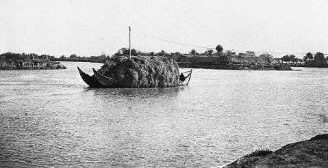
–– Tony J. Wilkinson ––
with the famous irrigation systems of southern Arabia, but also the fields must gradually have been raised by siltation relative to the level of the inlet canals, thereby slowing down flow even more and encouraging further sedimentation. Because rivers, canals and fields were all gradually aggrading, the entire hydraulic landscape required considerable effort to constrain this to within an acceptable amount, or alternatively to remodel the system so that it continued to function.
RIVERS AND CANALS AS TRANSPORTATION NETWORKS
It has long been recognised that canals and channels were as important as transport routes as they were for conducting irrigation water, a theme that remains central to the so-called ‘Mesopotamian Advantage’ (Sauren 1966: 36; Algaze 2008). The branching ‘low sinuosity’ river systems were ideal for the mobilisation of bulk goods from city to city (Figure 2.6; Algaze 2008: 51–62; Potts 1997: 28) so that not only did they provide an excellent distribution system, but also like many modern road systems they functioned as a network that was capable of being extended. Thus the large Iturungul canal of probably third millennium BC ‘provided a connective link in an enclosing network of natural and artificial watercourses serving the major southern Mesopotamian cities’ (Adams, 2008: 6, 9; Adams 1981: figs 18, 21; Steinkeller 2001: 40 map 1). Furthermore, any open water marshlands would also have increased the connectivity of the channel system (Pournelle 2007). Such increased connectivity is important because it indicates how just one extra link in a network can improve the overall connectivity of that system thereby making it much more efficient to transport goods throughout the entire network.
Apparently the scale of grain shipments during the Ur III state was so significant that perhaps half of the gross harvest from Umma’s cultivated lands, according to state records, moved by barge especially between the major Ur III urban centres of Ur, Uruk and Nippur (Sharlach 2004: 27, 161; Adams 2008: 9). Nevertheless, the rivers and
Figure 2.6 Bulk transport of reeds by boat. Photo: V 009, courtesy of the Gertrude Bell Archives.
48
–– Hydraulic landscapes and irrigation systems ––
canals must have served multiple functions so that when, for example, dams were inserted to guide water into canals they must have interfered with the movement of boats.
LEGAL AND ADMINISTRATIVE ASPECTS OF IRRIGATION
Canal construction was frequently a royal undertaking and many canals are credited to specific kings (Walters 1970: 144). Thus cuneiform texts not only demonstrate the concerns of the kings to provision the populace with good water and to create new agricultural lands (Potts 1997: 21) but they also provide insights into the layout of the canals. For example, canals are sometimes referred to as being extended to the sea (Potts 1997: 21; Cooper 1986: 70; Jacobsen 1960: 174–185). In other cases, canals may have operated as boundaries (Jacobsen 1960: 178); however, because the term ‘ég’, which is often interpreted as a canal, was probably a bank of up-cast from a canal, features which represented boundaries between states, such as that between Umma and Lagash, may simply have been linear banks (Postgate 1994: 182–183).
Moreover, the generosity of both gods and the king as suppliers of abundance was celebrated:
that the vast fields might grow rich, that the ditches and canals of Lagash be full to the brim, that in the plain . . . the grain goddess . . . might proudly look up . . ., that after the good fields have brought barley, emmer and all kinds of pulses, enormous grain heaps, the whole yield of the land of Lagash might be heaped up.
(Edzard 1997: 75–76 cited in Winter 2007: 120)
Although fundamentally a communal enterprise that requires human cooperation in order to function, irrigation systems were also the focus of disputes that needed to be resolved within a legal framework (Bruun in Wikander 2000). For example, according to the law code of Hammurabi, if a farmer failed to maintain the banks of his irrigation canals or let water flow on to another man’s fields thereby causing damage to crops, the farmer at fault was expected to pay damages (Bruun 2000; Postgate 1994: 182). Although these laws as written were Babylonian, they may have been based on Sumerian precedents.
Irrigated lands and estates
Although there is explicit evidence for the role of the king in the construction of major water works, most scholars accept that the temple was not the state (Postgate 1994: 115; Gibson 2010: 86–87), and its role in the organisation of the entire system of irrigation is now questioned (Rost 2010). Nevertheless, much irrigation was harnessed to supply large institutional estates, many under the administration of the king, and it is therefore important to understand how such estates developed from earlier small-scale agriculture.
The tendency for certain types of field and garden areas to evolve through time can be inferred from the work of agricultural consultants in the 1950s. Poyck (1962: 75), for example, makes the counter-intuitive point that tenant farmers enjoyed a higher standard of living than most owner occupiers. This is because they sowed relatively
49
–– Tony J. Wilkinson ––
large areas of land, albeit at a relatively low yield and return, which necessarily resulted in the deployment of large areas of fallow also available for grazing, which resulted in significant ‘wealth on the hoof’. This exceeded that of the owner occupiers, who had less land at their disposal for grazing. In other words, tenants of larger holdings, despite their requirement to pay a significant proportion of their production to the estate owner, would generate more wealth. As Fernea (1970: 48) reminds us, the role of fallow is therefore not only essential to allow for leaching of salts, it is also advantageous for building up large herds.
Because share cropping on large estates was perhaps more profitable than income from dependent farmers (Fernea 1970: 48), it is therefore possible to imagine (but difficult to prove) that in early Sumer, estates which taxed dependent farmers could grow at the expense of smaller household plots. Furthermore, large land holdings such as estates would also benefit from economies of scale because many of the tasks performed were more efficient when they were conducted on a large scale (Postgate 1994: 188). Because smaller holdings were probably associated with palm gardens along the levee crest, the estates probably grew relative to them and extended down slope to form the cereal zone described above.
CONCLUSIONS
Water clearly played a fundamental role in the development of Sumerian civilisation, although the Sumerian farmer often had to devote as much time in getting rid of it as collecting it to nurture crops. Whereas Ubaid landscapes probably formed a mosaic of riverine gardens, wetlands with ‘turtle back’ islands and desert steppe, by the third millennium BC settlements appear to have gravitated towards levees so that both towns and irrigation systems became aligned. Although marshes would have remained important, some were evidently drained whereas others would have grown as a result of the discharge of excess water from canals.
When cuneiform and field evidence are combined, it can be inferred that areas such as that around Umma consisted of relatively narrow cultivated zones between which would have extended areas of desert-steppe and marsh, which was itself a valuable resource. Although evidence exists for the construction of larger canals, especially in the later third millennium BC, most appear to have been less than 5 km long and only in the Ur III-Isin-Larsa period did the landscape include longer canals (Adams 1981: fig. 31), a pattern that became particularly evident by the later second millennium BC (Ur this volume fig. 7.8).
Sumerian irrigation, rather than being a monolithic system dominated by a theocratic state, therefore was probably more heterogeneous and less centrally managed than previously thought (Rost 2010: 3). Moreover, there is now little support for the notion that the need to irrigate large irrigation systems actually created the state as argued by Wittfogel (1957). Instead, shorter canals leading from the main channels could have been readily organised by Sumerian communities in the same way as recent kin-based social systems in southern Iraq (Fernea 1970). There is also no reason why the state should have controlled everything because in modern systems both statecontrolled administration (upstream) and independent or privately owned systems (downstream) co-exist (Ertsen 2010). In other words, in Sumer, the state or the king could have sponsored and built the main infrastructure and controlled estates, while
50
–– Hydraulic landscapes and irrigation systems ––
local kin-based or tribal communities could have organised much of the remainder. Because cuneiform tablets only provide a record of the state-controlled system, it is evident that irrigation, although perhaps providing the backbone of state production, may only have provided an unknown proportion of total production.
ACKNOWLEDGEMENTS
Particular thanks go to the University of Chicago MASS project and colleagues for discussions that contributed to this article: specific thanks go to Mac Gibson, Magnus Widell, Carrie Hritz, Jonathan Tenney, Stephanie Rost, Benjamin Studevent-Hickman, Jason Ur and Tate Paulette. I am especially grateful to the editor, Harriet Crawford, for her patience.
REFERENCES
Adams, R.McC. 1978. Strategies of Maximization, Stability, and Resilience in Mesopotamian Society, Settlement, and Agriculture. Proceedings of the American Philosophical Society 127: 329–335.
——1981. Heartland of Cities. Surveys of ancient settlement and land use on the central floodplain of the Euphrates. Chicago: University of Chicago Press.
——2008. An Interdisciplinary Overview of a Mesopotamian City and its Hinterlands. Cuneiform Digital Library Journal 2008: 1 (UCLA).
Adams, R.McC and Nissen H. 1972. The Uruk Countryside. Chicago: University of Chicago Press. Algaze, G. 2008. Ancient Mesopotamia at the Dawn of Civilization. Chicago: University of Chicago
Press
Bruun, C. 2000. Water Legislation in the Ancient World (c. 2200 BC–c. AD 500.) In Handbook of Ancient Water Technology, Ö.Wikander (ed.), pp. 539–604. Leiden: Brill.
Buringh, P. 1960. Soils and Soil Conditions in Iraq. Baghdad: Republic of Iraq, Ministry of Agriculture.
Charles, M.P. 1988. Irrigation in lowland Mesopotamia. Bulletin on Sumerian Agriculture 4: 1–39. —— 1990. Traditional crop husbandry in southern Iraq 1900–1960. Bulletin on Sumerian Agriculture
5: 47–64.
Civil, Miguel. 1994. The Farmer’s Instructions. Barcelona: Aula Orientalis.
Cole, S.W. and Gasche, H. 1998. Secondand first-millennium BC rivers in northern Babylonia. In
Changing watercourses in Babylonia. Towards a reconstruction of the ancient environment in lower Mesopotamia, H. Gasche, and Tanret, M. (eds). Chicago: University of Ghent and the Oriental Institute of the University of Chicago.
Cooper, J.S. 1986. Sumerian and Akkadian Royal Inscriptions, I: Presargonic Inscriptions. New Haven, CT: American Oriental Society.
Cotha Consulting Engineers. 1959a. Drainage Investigations in Gharraf East area. Baghdad: Republic of Iraq Ministry of Agriculture, Directorate General of Irrigation, Final Report, accompanying maps.
Cotha Consulting Engineers. 1959b. Drainage investigations in Gharraf East area. Baghdad: Republic of Iraq, Ministry of Agriculture, Directorate General of Irrigation Final Report, vol. II, appendix 2.
Crawford, H. 2004. Sumer and the Sumerians (2nd edition). Cambridge: Cambridge University Press. Dahl, J. 2007. The Ruling Family of Ur III Umma. Leiden: Nederlands Instituut voor het Nabije
Oosten.
Edzard, D.O. 1957. Die ‘zweite Zwischenzeit’ Babyloniens. Wiesbaden: Harrassowitz.
—— 1997. Gudea and his Dynasty. In The Royal Inscriptions of Mesopotamia, Early Periods 3/1.
Toronto: University of Toronto.
51
–– Tony J. Wilkinson ––
Ertsen, M.W. 2010. Structuring properties of irrigation systems: understanding relations between humans and hydraulics through modelling. Water History 2 (2): 165–183.
Fernea, Robert A. 1970. Shaykh and Effendi. Changing Patterns of Authority among the El Shabana of Southern Iraq. Cambridge, MA: Harvard University Press.
Flückiger-Hawker, E. 1999. Urnamma of Ur in Sumerian Literary Tradition. OBO 166. Fribourg: University Press.
Frayne, D. 1990. Royal Inscriptions of Mesopotamia. Early Periods vol. 4 (2003–1595 BC). Toronto: University of Toronto Press.
GB Admiralty. 1918. A Handbook of Mesopotamia. London: Intelligence Division. Gibson, McG. 1972. The City and Area of Kish. Miami: Field Research Publications.
——1973. Population shift and the rise of Mesopotamian civilisation. In The Explanation of Culture Change: models in prehistory, Colin Renfrew (ed.), pp. 447–463. London: Duckworth.
——1974. Violation of fallow and engineered disaster in Mesopotamian civilization. In Irrigation’s Impact on Society, T.E. Downing and McG. Gibson (eds), pp. 7–19. Tucson: University of Arizona Press.
——2010. The Dead Hand of Deimel. In Beyond the Ubaid: Transformation and Integration in the Late Prehistoric Societies of the Middle East, R.A. Carter and G. Philip (eds). Chicago: SAOC 63, Oriental Institute.
Guest, E. 1933. Notes on plants and plant products with their colloquial names in Iraq. Bulletin of the Department of Agriculture, 27, Baghdad, Iraq.
Heimpel, W. 1990. Ein zweiter Schritt zur Rehabilitierung der Rolle des Tigris in Sumer. Zeitschrift fur Assyriologie 80: 204–213.
Hritz, C. 2010. Tracing settlement patterns and channel systems in southern Mesopotamia using remote sensing. Journal of Field Archaeology 35 (2): 184–203.
Hritz, C. and Wilkinson, T.J. 2006. Using shuttle radar topography to map ancient water channels.
Antiquity 80: 415–424.
Hrusˇka, B. 2007. Agricultural techniques. In The Babylonian World, G. Leick (ed.), pp. 54–65. London: Routledge.
Hunt, R.C. 1988. Hydraulic management in southern Mesopotamia in Sumerian times. Bulletin on Sumerian Agriculture vol. IV, part 1: 189–206.
Huot, J-L. 1989. ‘Ubaidian villages of lower Mesopotamia. Permanence and evolution from ‘Ubaid
0 to ‘Ubaid 4 as seen from Tell el’ Oueili. In Upon This Foundation: The ‘Ubaid reconsidered, E.F. Henrickson and I. Thuesen (eds), pp.19–42. Copenhagen: Carsten Niebuhr Institute Publications 10.
Ionides, M.G. 1937. The Regime of the Rivers Euphrates and Tigris. London: E. and F. Spon. Jacobsen, T. 1960. The waters of Ur. Iraq 22: 174–185.
Jacobsen, T. and R. McC. Adams. 1958. Salt and silt in ancient Mesopotamian agriculture. Science
128: 1251–1258.
Liverani, M. 1996. Reconstructing the rural landscape of the ancient Near East. Journal of the Social and Economic History of the Orient 39: 1–49.
Morozova, G.S. 2005. A review of Holocene avulsions of the Tigris and Euphrates Rivers and possible effects on the evolution of civilizations in Lower Mesopotamia. Geoarchaeology 20:
401–423.
Naval Intelligence Division. 1944. Iraq and the Persian Gulf. Geographical Handbook B.R. 534. UK Government.
Neef, R. 1989. Plant remains from archaeological sites in lowland Iraq: Tell el ’Oueili. In Larsa: Travaux de 1985, J-L. Huot (ed.), pp. 321–329. Paris: Editions CNRS.
Oates, J. 1960. Ur and Eridu, the prehistory. Iraq 22: 32–50.
Paepe, R. 1971. Geological approach of the Tell ed-Der area. In Tell ed-Der I, L. De Meyer, H. Gasche and R. Paepe (eds.), pp. 9–27. Louvain: Editions Peeters.
Parrot, A. 1948. Tello: Vingt campagnes de fouilles (1877–1933). Paris: Albin-Michel.
52
–– Hydraulic landscapes and irrigation systems ––
Pemberton, W., J.N. Postgate and R.F. Smyth. 1988. Canals and bunds, ancient and modern. Bulletin on Sumerian Agriculture IV: 207–221.
Pollock, S. 1999. Ancient Mesopotamia: the Eden that Never Was. Cambridge: Cambridge University Press.
Postgate, J.N. 1990. A Middle Tigris Village. Bulletin on Sumerian Agriculture V: 65–74.
——1994. Early Mesopotamia: Society and Economy at the Dawn of History. London: Routledge. Potts, D.T. 1997. Mesopotamian Civilization: the material foundations. London: Athlone Press. Pournelle, J.R. 2003. Marshland of Cities: Deltaic Landscapes and the Evolution of Early Mesopotamian
Civilization. Ph.D. dissertation, Dept of Anthropology, University of California, San Diego. Pournelle, J.R. 2007. KLM to CORONA: A bird’s eye view of cultural ecology and early
Mesopotamian urbanization. In Settlement and Society: Essays Dedicated to Robert McCormick Adams, E. Stone (ed.), pp. 29–62. Los Angeles: UCLA Cotsen Institute.
Poyck, A.P.G. 1962. Farm Studies in Iraq: an agro-economic study of the agriculture in the HillaDiwaniya area in Iraq. Mededelingen van de Landbouwhogeschool te Wageningen 62 (1).
Powell, M.A. 1985. Salt, Seed, and Yields in Sumerian Agriculture: A Critique of the Theory of Progressive Salinization. Zeitschrift fur Assyriologie 75: 7–38.
——1988. Evidence for agriculture and waterworks in Babylonian mathematical texts. Bulletin on Sumerian Agriculture IV: 161–72.
Rost, S. 2010. Irrigation Management in the Ur III period: A Reconsideration based on a Case Study of the Maintenance of the íd-NINA-ˇès-DU Canal of the Province Lagasˇ. In Die empirische Dimension altorientalischer Forschungen, Selz, G.J. and Wagensonner, K. (eds), Wiener Offene Orientalistik. 6. Vienna.
Rost, S. and Hamdani, A.A. (in press). Traditional dam construction in 20th century Iraq: a possible analogy for the understanding of ancient irrigation practices in Mesopotamia. Iraq.
Sauren, H. 1966. Topography der Provinz Umma nach den Urkunden der Zeit der III. Dynastie von Ur. Teil I: Kanäle und Bewässerungsanlagen. Heidelberg: K. Urlaub.
Sharlach, T.M. 2004 Provincial Taxation and the Ur III State. Cuneiform Monographs 26. LeidenBoston: Brill-Styx.
Steinkeller, P. 1987. The Administration and Economic Organization of the Ur III State: The Core and the Periphery. In M. Gibson and R. D. Biggs, (eds.), The Organization of Power: Aspects of Bureaucracy in the Ancient Near East. Chicago, Oriental Institute: SAOC 46, pp. 119–141.
—— 2001. New light on the hydrology and topography of southern Babylonia in the third millennium. Zeitschrift fur Assyriologie 91: 22–84.
Verhoeven, K. 1998. Geomorphological research in the Mesopotamian floodplains. In Changing watercourses in Babylonia. Towards a reconstruction of the ancient environment in lower Mesopotamia, H. Gasche and Tanret, M. (eds), pp. 159–245. Chicago: University of Ghent and the University of Chicago Oriental Institute.
Walters, S.D. 1970. Water for Larsa; an Old Babylonian archive dealing with irrigation. New Haven: Yale University Press.
Widell, M. 2008. Lecture at the 2009 BANEA meeting, Durham, UK.
Wilkinson, J.C. 1977. Water and Tribal Settlement in Oman. A Study of the Aflaj of Oman. Oxford: Clarendon Press.
Wilkinson, T.J. 2003. Archaeological Landscapes of the Near East. Tucson: University of Arizona Press. Wilkinson, T.J., McG. Gibson, J.H. Christiansen, M. Widell, D. Schloen, N. Kouchoukos, C.
Wood, J. Sanders, K.-L. Simunich, M. Altaweel, J.A. Ur, C. Hritz, J. Lauinger, T. Paulette, and J. Tenney. 2007. Modeling settlement systems in a dynamic environment: case studies from Mesopotamia. In The Model-Based Archaeology of Socio-Natural Systems, T.A. Kohler and S.E. van der Leeuw (eds), pp. 175–208. Santa Fe New Mexico: School for Advanced Research Press.
Winter, I. 2007. Representing Abundance: the visual representation of the Agrarian State. In
Settlement & Society: Essays dedicated to R McC. Adams E, Stone (ed.), pp.113–138. Los Angeles: UCLA Cotsen Institute.
53
–– Tony J. Wilkinson ––
Wittfogel, K. 1957. Oriental Despotism: A Comparative Study of Total Power. New Haven: Yale University Press.
Wood, C. 2005. On the Euphrates. Zeitschrifte fur Assyriologie 95: 7–45.
Wright, H. 1981. The southern margins of Sumer. Survey of the area of Eridu and Ur. In Heartland of Cities, Adams, R.McC. (ed.), pp. 295–345. Chicago: University of Chicago Press.
Zettler, R.L. 2003. Reconstructing the world of ancient Mesopotamia: divided beginnings and holistic history. Journal of the Economic and Social History of the Orient 46 (1): 3–44.
54
CHAPTER THREE
SUMERIAN AGRICULTURE
AND LAND MANAGEMENT
Magnus Widell
This chapter focuses on the agricultural landscape and the administration of fields, as well as agricultural procedures and production in the late third millennium, in particular in the period of the Third Dynasty of Ur.1 Other important forms of subsistence, such as pastoralism or horticulture, were organised and structured very differently in ancient Sumer, and will not be considered here. The Third Dynasty of Ur, or the Ur III state, refers to a ruling dynasty based in the city of Ur and their shortlived territorial state during the last century of the millennium. The Ur III period is often described as an extremely administrative and bureaucratic period of time with an unprecedented level of central authority. There is no denying that the administration and bureaucracy of this period was extensive and very well developed. However, it should be stated that this period was not all that different from both earlier and later periods, and it is clear that a large part of the organisation of the Ur III state rested on already established principles in ancient Mesopotamia, and this is especially true for agricultural procedures and production levels. Nevertheless, the roughly one hundred years of the Third Dynasty of Ur represent a period that is extremely well documented. In fact, with over 90,000 cuneiform tablets documenting the administrative affairs of the state published to date, and tens of thousands of additional tablets kept in museums and private collections around the world awaiting publication, the Ur III state is, at least from a purely quantitative point of view, the best documented era in
the entire history of ancient Mesopotamia.
Chronologically, these administrative and economic tablets are unevenly distributed over the century or so that was the Ur III state. As Figure 3.1 shows, almost no texts have been recovered from the earlier part of the state’s domination. We only have a handful of tablets from the eighteen-year reign of Ur-Namma, the founder and unifier of the Ur III state, and only the last seventeen years of the forty-eight-year reign of Ur-Namma’s successor, Shulgi, produced tablets in any significant numbers (i.e. from Shulgi year 32). Also the decline and eventual collapse of the Ur III state remain relatively poorly documented in the textual record. With the notable exception of IbbiSuen year 15, the final two decades of the state’s last king (i.e. from Ibbi-Suen’s fourth year) have only produced very modest numbers of cuneiform tablets.
In other words, we are dealing with an exceptionally short period of time with an extreme concentration of information. Roughly 83 per cent (49,009 tablets) of all the Ur III tablets with a known year date (59,015) come from a short period of twenty-five
55
–– Magnus Widell ––
3000 |
|
|
|
|
|
|
|
|
|
|
|
|
|
|
|
|
|
|
|
|
|
|
|
|
|
|
|
|
|
|
|
|
|
|
|
2500 |
|
|
|
|
|
|
|
|
|
|
|
|
|
|
|
|
|
|
|
|
|
|
|
|
|
|
|
|
|
|
|
|
|
|
|
2000 |
|
|
|
|
|
|
|
|
|
|
|
|
|
|
|
|
|
|
|
|
|
|
|
|
|
|
|
|
|
|
|
|
|
|
|
1500 |
|
|
|
|
|
|
|
|
|
|
|
|
|
|
|
|
|
|
|
|
|
|
|
|
|
|
|
|
|
|
|
|
|
|
|
1000 |
|
|
|
|
|
|
|
|
|
|
|
|
|
|
|
|
|
|
|
|
|
|
|
|
|
|
|
|
|
|
|
|
|
|
|
500 |
|
|
|
|
|
|
|
|
|
|
|
|
|
|
|
|
|
|
|
|
|
|
|
|
|
|
|
|
|
|
|
|
|
|
|
0 |
|
|
|
|
|
Š 2 |
|
|
|
|
|
|
|
|
|
|
|
|
|
|
|
|
|
|
|
|
|
|
|
|
|
|
|
|
|
UN 1 |
UN 4 |
UN 7 |
UN 10 |
UN 13 |
UN 16 |
Š 5 |
Š 8 |
Š 11 |
Š 14 |
Š 17 |
Š 20 |
Š 23 |
Š 26 |
Š 29 |
Š 32 |
Š 35 |
Š 38 |
Š 41 |
Š 44 |
Š 47 |
AS 2 |
AS 5 |
AS 8 |
ŠS 2 |
ŠS 5 |
ŠS 8 |
IS 2 |
IS 5 |
IS 8 |
IS 11 |
IS 14 |
IS 17 |
IS 20 |
IS 23 |
Figure 3.1 Chronological distribution of tablets during the five kings and 106 years of the Ur III
ˇ ˇ
state. Key: UN = Ur-Namma, S = Shulgi, AS = Amar-Suen, SS = Shu-Suen, IS = Ibbi-Suen (data retrieved from BDTNS, 18 December 2010)
years, from Shulgi’s forty-fourth year as king to the second year in Ibbi-Suen’s reign. It is this extreme level of administrative and economic documentation over only a few decades that make the Ur III state so suitable for a study attempting to recreate ancient Mesopotamian management of cultivated land, agricultural procedures and production levels. Like most ancient economies, the Mesopotamian economy was based on agriculture, and the textual evidence from the Ur III period provides very detailed information on practically every aspect of the agricultural production, and offers a wide range of very specific data that would be very difficult, or impossible, to obtain with an equivalent level of detail and/or reliability through studies of alternative material.
For the reconstruction of Sumerian agricultural procedures, we are almost exclusively dependent upon textual evidence, while data derived from the material culture remain of a relatively minor importance (Hruska 2007: 54 and 63, n. 1). It should be noted, however, that this is only partly a result of the agricultural focus and the relative abundance of cuneiform tablets in the third millennium, and perhaps reflects a general overestimation of the importance of written sources once they occur in the archaeological record. As noted by Hans Nissen (1988: 3–4), a prevailing, and entirely unrealistic, assumption that the numerous cuneiform tablets of the third millennium will answer all our questions regarding the period’s social and economic history has regrettably resulted in a situation where crucial archaeological data on flora and fauna from historical times have been neglected in archaeological excavations and subsequent studies.
56
–– Sumerian agriculture and land management ––
Since the Ur III tablets, like most Sumerian cuneiform documents, almost exclusively stem from the archives of the major government households, they primarily emphasise the importance of the agricultural work within such public agencies, and any possible small-scale agricultural exploitation conducted by smaller households or individual families remain virtually unattested in the written documentation of the third millennium.
THE AGRICULTURAL LANDSCAPE
During the second half of the fourth millennium BC, a series of climatic changes and ensuing effects in the landscape profoundly changed the way of life in southern Mesopotamia. A relatively sudden increase in average temperatures coupled with decreasing levels of precipitations resulted in reduced flows in both the Euphrates and the Tigris, impacting the sedimentation of the Mesopotamian plain (Kay and Johnson 1981: 259 and fig. 4; see also Hole 1994: 127–131, and Potts 1997: 4–5). Within the space of a few hundred years, the annual floods that regularly covered large tracts of land in the south were largely stemmed, leading to the gradual silting up of much of the swamps and marches that made up the estuary of the two rivers. New and fertile land became available for cultivation, while the decrease of violent spring floods made longterm settlements along the rivers possible, especially along the Euphrates. However, the aridification following the climate change also meant that the rainfall in southern Mesopotamia in the third millennium would have been less than 250 millimetres per annum, and would not be able to sustain agriculture. The urbanisation of southern Mesopotamia and the organisation and concentration of labour facilitated the construction and maintenance of large-scale irrigation systems, and the resulting modes of suprafamily collaborations made it possible to administer and control the southern Mesopotamia essential biannual fallow regime (see Steinkeller 1999: 302f.). The collective and extensive irrigation works, on which all depended, would in turn no doubt have intensified the social cohesion within the urban centres.2 As Robert McC. Adams writes about the Mesopotamian city, and its inseparable connection to the agricultural landscape of ancient Sumer (1981: 2):
How firmly the occupants of the lower Mesopotamian plain ever recognized that alluvial terrain as a special object of attachment is uncertain, but their enduring loyalty to familiar associations and localities within it – to cities – is not a matter of doubt. Here we are concerned with the material conditions that must have played an important part in originating and sustaining these roots of attachment. And it is impossible to escape the conviction that irrigation agriculture – or the comparative security, population density and stability, and social differentiation and complexity that it induced – was at the very heart of these material conditions.
By paraphrasing Frank Hole, we may summarise the overall principles and features of the Sumerian agricultural landscape as follows (1994: 138): the climate shift of the fourth millennium made large-scale artificial irrigation a requirement for successful agriculture in ancient Sumer. Such irrigation systems were extremely vulnerable and had to be renewed annually. The necessary size of the systems, and the general labour intensity of the annual repair works, required a sizable organisation that went far
57
–– Magnus Widell ––
beyond the traditional family household. On the other hand, irrigation opened up new land to highly productive agricultural exploitation, which enabled the Mesopotamian floodplain to support a large population.
Topography and agricultural fields
While rural exploitation in the entire land of Sumer certainly always required artificial irrigation, topographical and environmental differences within southern Mesopotamia gave rise to significant regional variations in the nature of the necessary irrigation regimes. The area south-east of the major Sumerian cities, such as Eridu, Ur and Lagash, towards the coast of the Persian Gulf, was defined by lakes and permanent marshes. The ground water table was extremely high in the region, and agricultural work was largely impossible (Sanlaville 1989: 9).
Immediately upstream of the marshes and lagoons was a vast plain, characterised by extensive alluvial sedimentation and an exceptionally low gradient of the land, averaging for the entire plain to as little as 3–4 centimetres per kilometre along the Tigris and 5–6 centimetres per kilometre along the Euphrates. The deltaic plain (plaine deltaïque) extended from the large Sumerian city states in the far south to approximately the area of Babylon and Kish in the heart of southern Mesopotamia. Throughout the deltaic plain, the ground water table remained very high, and salinisation of the otherwise very fertile soil remained a very serious problem for the farming communities in this area (Sanlaville 1989: 8).
The northern alluvial plain included the Diyala basin and major Sumerian cities, such as Sippar and Eshnunna, and stretched from Babylon and Kish in the south to the Jazirah plain on the Euphrates and the city of Samarra on the Tigris in the north. The broader area was dominated by a desert plateau, and agricultural exploitation was only possible in the narrow river valleys. The natural gradient of the land was approximately twice as high as on the deltaic plain, averaging about 7 centimetres per kilometre along the Tigris and approximately 10 centimetres per kilometre along the Euphrates, and sedimentation was not as pronounced as further down the rivers. The ground water table was relatively low in the area, and intense cultivation with little regard for the gradual increase of salt in the soil was therefore possible (Sanlaville 1989: 8).
As already noted by Mario Liverani (1997: 221), agricultural procedures and irrigation systems reflect not only ecological and topographical conditions, but also a range of socio-political and administrative realities in a particular region. The third millennium rural landscape in the deltaic plain was characterised by almost exclusively regular and elongated fields lined with furrows. Several detailed studies of a group of approximately seventy cadastral texts from the province of Lagash, primarily dated to the seventh and eighth years of the Ur III king Amar-Suen’s reign, have presented a picture of rural landscape in the south being dominated by elongated and rectangular strips of land. The majority of these strips of land would have ranged in size between 90 and 135 Sumerian iku (GAN2), which would equal approximately 32–49 hectares (see Liverani 1990, 1996; Maekawa 1992; Figure 3.2).
While it is easy to distinguish a certain uniformity in the sizes of the different fields, with the typical fields ranging from 90 to 135 iku (≈ 32–49 ha), and with more than half of the fields in the range 100–125 iku (≈ 36–45 ha), the exact shape (i.e. length–width ratio) of the different fields does not appear to have been standardised in the same way.
58
–– Sumerian agriculture and land management ––
60
50
40
30
20
10
|
|
|
|
|
|
|
|
|
20 |
40 |
60 |
80 |
100 120 140 160 180 200 220 240 260 280 300 320 340 |
560 580 |
|||
Figure 3.2 Size measurements (in Sumerian iku) of the 452 fields (a-ˇs a3) measured in the Lagash cadastral texts. Approximately 55 per cent of the fields ranged from 100 to 125 iku (≈ 36-45 ha; dark grey) while roughly 70 per cent were in the range 90–135 iku (≈ 32-49 ha; dark + light grey) (chart adapted from Liverani 1996: 156; see also Civil 1991: 42)
In his study of the agricultural fields of southern Mesopotamia, Liverani stated that the lengths of the field areas typically exceeded the widths by a factor of ten, and he emphasised the extreme length and narrowness of the fields (1990: 158; 1996: 21). However, a closer analysis of Liverani’s own data and his chart plotting the length– width ratio of the field areas reveals that although fields with a length–width ratio of 10 to 1, or even 20 or 30 to 1, certainly can be confirmed in the textual material, such extremely long and narrow fields did not dominate the rural landscape of southern Mesopotamia, and roughly 61 per cent of all the fields were less than eight times longer than they were wide (Figure 3.3, Table 3.1). The typical field (i.e. the median field) was roughly 6.5 times longer than it was wide.
FIELD MANAGEMENT
Liverani recognised the congruity in the sizes of the recorded fields, and he suggested that the standard field size in the Ur III administration was supposed to be 100 iku (i.e. 100 x 100 ninda, corresponding approximately to 36 hectares), although he also observed that the fields often exceeded this suggested standard, and that the average field size actually seemed to be around 115 iku (Liverani 1990: 157). This assumption
59
|
|
|
|
|
|
|
|
|
|
|
|
|
–– Magnus Widell –– |
|
|
|
|
|
|
|
|
|
|
|
|
|
|
|||||||||
100 |
|
|
|
|
|
|
|
|
|
|
|
|
|
|
|
|
|
|
|
|
|
|
|
|
|
|
|
|
|
|
|
|
|
|
|
|
|
|
|
|
|
|
|
|
|
|
|
|
|
|
|
|
|
|
|
|
|
|
|
|
|
|
|
|
|
|
|
|
|
|
|
|
|
|
|
1:1 |
|
|
|
|
|
|
|
|
|
|
|
|
|
|
|
|
5:1 |
|
|
|
|
|
|
|
|
|
|
|
|
|
|
|
|
|
|
|
|
|
|
|
|
|
|
|
|
|
|
|
|
|
|
|
|
|
|
|
|
|
|
|
|
|
|
|
|
|
|
|
|
||
90 |
|
|
|
|
|
|
|
|
|
|
|
|
|
|
|
|
|
|
|
|
|
|
|
|
|
|
|
|
|
|
|
|
|
|
|
|
|
|
|
|
|
|
|
|
|
|
|
|
|
|
|
|
|
|
|
|
|
|
|
|
|
|
|
|
|
|
|
|
|
10:1 |
|
||
80 |
|
|
|
|
|
|
|
|
|
|
|
|
|
|
|
|
|
|
|
|
|
|
|
|
|
|
|
|
|
|
|
|
|
|
||
|
|
|
|
|
|
|
|
|
|
|
|
|
|
|
|
|
|
|
|
|
|
|
|
|
|
|
|
|
|
|
|
|
|
|
|
|
70 |
|
|
|
|
|
|
|
|
|
|
|
|
|
|
|
|
|
|
|
|
|
|
|
|
|
|
|
|
|
|
|
|
|
|
|
|
|
|
|
|
|
|
|
|
|
|
|
|
|
|
|
|
|
|
|
|
|
|
|
|
|
|
|
|
|
|
|
|
|
15:1 |
|
||
60 |
|
|
|
|
|
|
|
|
|
|
|
|
|
|
|
|
|
|
|
|
|
|
|
|
|
|
|
|
|
|
|
|
|
|
||
|
|
|
|
|
|
|
|
|
|
|
|
|
|
|
|
|
|
|
|
|
|
|
|
|
|
|
|
|
|
|
|
|
|
|
|
|
50 |
|
|
|
|
|
|
|
|
|
|
|
|
|
|
|
|
|
|
|
|
|
|
|
|
|
|
|
|
|
|
|
|
|
|
|
|
|
|
|
|
|
|
|
|
|
|
|
|
|
|
|
|
|
|
|
|
|
|
|
|
|
|
|
|
|
|
|
|
|
20:1 |
|
||
|
|
|
|
|
|
|
|
|
|
|
|
|
|
|
|
|
|
|
|
|
|
|
|
|
|
|
|
|
|
|
|
|
|
|
||
40 |
|
|
|
|
|
|
|
|
|
|
|
|
|
|
|
|
|
|
|
|
|
|
|
|
|
|
|
|
|
|
|
|
|
|
|
|
|
|
|
|
|
|
|
|
|
|
|
|
|
|
|
|
|
|
|
|
|
|
|
|
|
|
|
|
|
|
|
|
|
30:1 |
|
||
30 |
|
|
|
|
|
|
|
|
|
|
|
|
|
|
|
|
|
|
|
|
|
|
|
|
|
|
|
|
|
|
|
|
|
|
||
|
|
|
|
|
|
|
|
|
|
|
|
|
|
|
|
|
|
|
|
|
|
|
|
|
|
|
|
|
|
|
|
|
|
|
|
|
20 |
|
|
|
|
|
|
|
|
|
|
|
|
|
|
|
|
|
|
|
|
|
|
|
|
|
|
|
|
|
|
|
|
|
|
|
|
|
|
|
|
|
|
|
|
|
|
|
|
|
|
|
|
|
|
|
|
|
|
|
|
|
|
|
|
|
|
|
|
|
|
|
|
|
10 |
|
|
|
|
|
|
|
|
|
|
|
|
|
|
|
|
|
|
|
|
|
|
|
|
|
|
|
|
|
|
|
|
|
|
|
|
|
|
|
|
|
|
|
|
|
|
|
|
|
|
|
|
|
|
|
|
|
|
|
|
|
|
|
|
|
|
|
|
|
|
|
|
|
|
|
|
|
|
|
|
|
|
|
|
|
|
|
|
|
|
|
|
|
|
|
|
|
|
|
|
|
|
|
|
|
|
|
|
|
|
50 |
100 |
150 |
200 |
250 |
300 |
350 |
400 |
450 |
500 |
550 |
600 |
650 |
700 |
750 |
800 |
850 |
900 |
|||||||||||||||||||
Figure 3.3 |
Shapes of the 269 fields (a-ˇs a3) measured in the Lagash cadastral texts. The vertical axis |
|||||||||||||||||||||||||||||||||||
is showing the width and the horizontal axis the length of the fields in the Sumerian length |
|
|
||||||||||||||||||||||||||||||||||
|
measurement ninda (1 ninda ≈ 6 metres) (chart adapted from Liverani 1990: 168) |
|
|
|
|
|||||||||||||||||||||||||||||||
Table 3.1 |
Proportions (length: width) of the 269 fields in the Lagash cadastral texts |
|
|
|
|
|
|
|||||||||||||||||||||||||||||
|
|
|
|
|
|
|
|
|
|
|
|
|
|
|
|
|
|
|
|
|
|
|
|
|
|
|
||||||||||
Length : Width |
|
|
Fields |
|
|
Percent |
|
|
|
|
|
|
|
|
|
|
|
|
|
|
|
|
|
|
|
|
||||||||||
|
|
|
|
|
|
|
|
|
|
|
|
|
|
|
|
|
|
|
|
|
|
|
|
|
|
|
|
|
|
|
|
|
|
|||
< 1 : 1 |
|
|
|
|
|
2 |
|
|
|
|
1% |
|
|
|
|
|
|
|
|
|
|
|
|
|
|
|
|
|
|
|
|
|
|
|||
1 : 1 – 5 : 1 |
|
|
|
|
100 |
|
|
|
|
37% |
|
|
|
|
|
|
|
|
|
|
|
|
|
|
|
|
|
|
|
|
|
|
||||
5 : 1 – 10 : 1 |
|
|
80 |
|
|
|
|
30% |
|
|
|
|
|
|
|
|
|
|
|
|
|
|
|
|
|
|
|
|
|
|
||||||
10 : 1 – 15 : 1 |
|
|
23 |
|
|
|
|
9% |
|
|
|
|
|
|
|
|
|
|
|
|
|
|
|
|
|
|
|
|
|
|
||||||
15 : 1 – 20 : 1 |
|
|
41 |
|
|
|
|
15% |
|
|
|
|
|
|
|
|
|
|
|
|
|
|
|
|
|
|
|
|
|
|
||||||
20 : 1 – 30 : 1 |
|
|
9 |
|
|
|
|
3% |
|
|
|
|
|
|
|
|
|
|
|
|
|
|
|
|
|
|
|
|
|
|
||||||
> 30 : 1 |
|
|
|
|
|
14 |
|
|
|
|
5% |
|
|
|
|
|
|
|
|
|
|
|
|
|
|
|
|
|
|
|
|
|
|
|||
Total |
|
|
|
|
269 |
|
|
|
|
100% |
|
|
|
|
|
|
|
|
|
|
|
|
|
|
|
|
|
|
|
|
|
|
||||
|
|
|
|
|
|
|
|
|
|
|
|
|
|
|
|
|
|
|
|
|
|
|
|
|
|
|
|
|
|
|
|
|
|
|
|
|
Note: Approximately 38 per cent of the fields had a length that was less than five times their width, and more than two-thirds (roughly 68 per cent) were proportioned between 1:1 and 10:1 (length:width).
of a standardised (or ideal) Ur III field measuring 100 iku was corrected by Kazuya Maekawa (1992: 408), who pointed out that the standard size was not measured in iku but in the alternative surface measurement bur3, and that the ideal Ur III field was supposed to measure 6 bur3, which would equal roughly 39 hectares (1 bur3 ≈ 6.48 ha). This is an important observation and correction by Maekawa because it allows us to accurately reconstruct how these areas of land were further (theoretically) grouped together or subdivided from an administrative point of view.
The cadastral texts themselves tell us that each field area, or perhaps better domain parcel,3 was the ultimate responsibility of a state administrator referred to as engar, best translated as ‘cultivator’. Based on a land survey text from Umma, Maekawa (1987: 36–40) has demonstrated that the Ur III ‘cultivators’–usually in groups of five–were under the direction of an ‘inspector of plough oxen’ (nu-banda3 gu4), who in turn
60

–– Sumerian agriculture and land management ––
answered to an ‘overseer’ (ugula4) in charge of two ‘inspectors of plough oxen’ (and therefore normally in charge of ten ‘cultivators’ and ten domain parcels) (Figure 3.4).
Each ‘cultivator’ in charge of one field, or domain parcel, employed three ‘ox drivers’ (ˇas3-gu4). Since the surface of 6 bur3 (as opposed to the surface of 100 iku) can easily
be divided into three equal units, each measuring one square U ˇ (≈ 360 x 360 metres),
S
it seems reasonable to assume that this represented the ideal size of cultivation under
the responsibility of each ‘ox driver’. Each square U ˇ would be further subdivided into
S
six family-sized plots measuring one esˇe3 (2.16 hectares) (Figure 3.5).
The esˇe3 measurement equals 6 iku, and each iku can be further divided into 100 ˇars , the traditional Sumerian garden plot, measuring approximately 6 x 6 metres.
The use of integral numbers of the bur3 for the measurements of field areas is not surprising given that the bur3 served as the basis for calculations of sowing rates in the Ur III period, with one bur3 of cultivated land typically receiving one gur of barley seed (≈ 300 litres) (Maekawa 1984: 87). Thus, the standard amount of seed for the 6 bur3 ‘field’ in these texts would be 6 gur (≈ 1,800 litres), the unit of the ˇas3-gu4 2 gur (≈ 600
ugula
(10 fields)
nu-banda3 gu4
(5 fields)
nu-banda3 gu4
(5 fields)
|
|
|
|
|
|
|
|
|
|
|
|
|
|
|
|
|
|
|
|
|
|
|
|
|
|
|
|
|
|
|
|
|
|
|
|
|
|
|
|
|
|
|
|
|
|
|
|
|
|
|
|
|
|
|
|
|
|
|
|
|
|
|
|
|
|
engar |
|
engar |
|
engar |
|
engar |
|
engar |
|
engar |
|
engar |
|
engar |
|
engar |
|
engar |
||||||||||||||
(1 field) |
|
(1 field) |
|
(1 field) |
|
(1 field) |
|
(1 field) |
|
(1 field) |
|
(1 field) |
|
(1 field) |
|
(1 field) |
|
(1 field) |
||||||||||||||
|
|
|
|
|
|
|
|
|
|
|
|
|
|
|
|
|
|
|
|
|
|
|
|
|
|
|
|
|
|
|
|
|
Figure 3.4 Organisation of the supervision of fields and field workers in the Ur III period. See note 4 for alternative professional titles of the top official responsible for ten fields.
|
|
|
|
|
|
|
|
|
|
|
|
|
|
|
|
|
|
|
|
|
|
|
|
|
a-ša3 “field” |
|
|
|
|
|
|
|
|
|
|
|
|
|
|
|
|
|
|
|
|
|
|
||||||||
|
|
|
|
|
|
|
|
|
|
|
|
|
|
|
|
|
|
|
|
|
|
|
|
|
6 bur3 (38.88 ha) |
|
|
|
|
|
|
|
|
|
|
|
|
|
|
|
|
|
|
|
|
|
|
||||||||
|
|
|
|
|
|
|
|
|
|
|
|
|
|
|
|
|
|
|
|
|
|
|
|
|
|
|
|
|
|
|
|
|
|
|
|
|
|
|
|
|
|
|
|
|
|
|
|
|
|
|
|
|
|
|
|
|
|
|
|
|
|
|
|
|
|
|
|
|
|
|
|
|
|
|
|
|
|
|
|
|
|
|
|
|
|
|
|
|
|
|
|
|
|
|
|
|
|
|
|
|
|
|
|
|
|
|
|
|
|
|
|
|
|
|
|
|
|
|
|
|
|
|
|
|
|
|
|
|
|
|
|
|
|
|
|
|
|
|
|
|
|
|
|
|
|
|
|
|
|
|
|
|
|
|
|
|
|
|
|
|
|
|
|
|
|
|
|
|
|
|
|
|
|
|
Unit of ša3-gu4 |
|
|
|
|
|
|
|
|
|
Unit of ša3-gu4 |
|
|
|
|
|
|
|
|
|
Unit of ša3-gu4 |
|
|
|
|
|
|
|
|||||||||||||||||||||
|
|
|
|
|
|
|
UŠ × UŠ (12.96 ha) |
|
|
|
|
|
|
|
|
|
UŠ × UŠ (12.96 ha) |
|
|
|
|
|
|
|
|
|
UŠ × UŠ (12.96 ha) |
|
|
|
|
|
|
|
|||||||||||||||||||||
|
|
|
|
|
|
|
|
|
|
|
|
|
|
|
|
|
|
|
|
|
|
|
|
|
|
|
|
|
|
|
|
|
|
|
|
|
|
|
|
|
|
|
|
|
|
|
|
|
|
|
|
|
|
|
|
|
|
|
|
|
|
|
|
|
|
|
|
|
|
|
|
|
|
|
|
|
|
|
|
|
|
|
|
|
|
|
|
|
|
|
|
|
|
|
|
|
|
|
|
|
|
|
|
|
|
|
|
|
|
|
|
|
|
|
|
|
|
|
|
|
|
|
|
|
|
|
|
|
|
|
|
|
|
|
|
|
|
|
|
|
|
|
|
|
|
|
|
|
|
|
|
|
|
|
|
|
|
|
|
|
|
|
|
|
|
|
|
eše3 |
|
eše3 |
|
eše3 |
eše3 |
|
|
|
eše3 |
|
|
|
eše3 |
|
|
eše3 |
|
|
eše3 |
|
|
eše3 |
eše3 |
|
eše3 |
|
eše3 |
||||||||||||||||||||||||||||
2.16 ha |
|
2.16 ha |
|
2.16 ha |
2.16 ha |
|
|
2.16 ha |
|
|
2.16 ha |
|
|
2.16 ha |
|
|
2.16 ha |
|
|
2.16 ha |
2.16 ha |
|
2.16 ha |
|
2.16 ha |
||||||||||||||||||||||||||||||
|
|
|
|
|
|
|
|
|
|
|
|
|
|
|
|
|
|
|
|
|
|
|
|
|
|
|
|
|
|
|
|
|
|
|
|
|
|
|
|
|
|
|
|
|
|
|
|
|
|
|
|
|
|
|
|
|
|
|
|
|
|
|
|
|
|
|
|
|
|
|
|
|
|
|
|
|
|
|
|
|
|
|
|
|
|
|
|
|
|
|
|
|
|
|
|
|
|
|
|
|
|
|
|
|
|
|
|
||||
|
|
|
|
|
|
|
|
|
|
|
|
|
|
|
|
|
|
|
|
|
|
|
|
|
|
|
|
|
|
|
|
|
|
|
|
|
|
|
|
|
|
|
|
|
|
|
|
|
|
|
|
|
|
|
|
|
|
|
|
|
|
|
|
|
|
|
eše3 |
|
|
|
eše3 |
|
|
|
eše3 |
eše3 |
|
|
|
eše3 |
|
|
|
eše3 |
|
|
|
|
|
|
|
|
|
|
|||||||||||||||||
|
|
|
|
|
|
|
|
|
|
2.16 ha |
|
|
2.16 ha |
|
|
2.16 ha |
2.16 ha |
|
|
2.16 ha |
|
|
2.16 ha |
|
|
|
|
|
|
|
|
|
|
||||||||||||||||||||||
|
|
|
|
|
|
|
|
|
|
|
|
|
|
|
|
|
|
|
|
|
|
|
|
|
|
|
|
|
|
|
|
|
|
|
|
|
|
|
|
|
|
|
|
|
|
|
|
|
|
|
|
|
|
|
|
Figure 3.5 Administrative division of a ‘field’ (a-ˇs a3) in the Ur III period
61
–– Magnus Widell ––
litres), the esˇe3 plot 1 barig and 4 ban2 (≈ 100 litres), and the single garden plot measuring one ˇars (≈ 6 x 6 metres) should ideally receive 10 gin2 seed (≈ 16.67 ml).
Of course, these divisions of the domain parcel merely represent abstract measurements of administrative responsibilities and accountabilities, and would not necessarily be physically defined in the agricultural landscape. The three ‘ox drivers’ would together be responsible for the ploughing of the entire 6 bur3 during the plough season (not just ‘their’ 2 bur3 units), and the various low-level agricultural workers assigned to the field as a whole would by no means be restricted to labour in individual esˇe3 plots.
Sustenance land
As mentioned above and in note 3, at least some of the agricultural workers on the provincial domain fields (GAN2 gu4) had usufruct rights to plots of arable lands referred to as GAN2ˇukus ‘sustenance field’. Depending on the status of the agricultural workers, these allotted fields varied in size, usually (or at least often) by a multiple of three (see Maekawa 1991: 213). The text BM 105334, recording a land survey in the province of Umma in Amar-Suen’s second year as a king, has shown that the sustenance land that was allotted to the ‘cultivators’ measured 1 esˇe3, or 6 iku, while the subordinate ‘ox drivers’ received sustenance parcels measuring half this size.5 Above the ‘cultivators’, the ‘inspectors of plough oxen’ were each given sustenance parcels measuring 3 esˇe3, or 1 bur3, for their services, while the overseer in charge of ten domain parcels received 9 esˇe3, or 3 bur3 (see most recently Koslova 2005 and Vanderroost 2008, with additional literature).
According to Remco de Maaijer (1998: 55), the sustenance land was included in the larger domain land area. However, as Natalia Koslova has argued (2005: 704), the fact that these two categories of land were consistently kept apart in the administrative documentation, implies that they were also separate units within the agricultural landscape. In fact, land survey texts such as the Girsu text BM 23622+28004, in which the summary sections recording one estate’s total holdings of domain land, sustenance land and tenant land (GAN2 nig2–gal2–la) can be compared to the sum of the individual entries of these types of land, seem to demonstrate that these three categories of land represented separate physical areas in the agricultural landscape (see Maekawa 1986).6 It is possible that de Maaijer’s position was influenced by Piotr Steinkeller, who a few years earlier had suggested that sustenance plots were not cultivated by their holders at all, and that the sustenance plots, although physically tied to specific fields, simply served as abstract measurements of individual rations (Steinkeller 1999: 303 and notes 51 and 52). The ‘holder’ of a sustenance plot would receive a fixed annual grain ration based on the plot size according to a predetermined production rate irrespective of the inevitable regional and annual yield fluctuations. However, Steinkeller presented no concrete evidence for this claim, beyond the correct observations that large-scale agriculture is more productive than small-scale farming in ancient Mesopotamia, and that centralised control over a large area of cultivation would facilitate more rigorous adherence to crucial fallowing patterns. Moreover, Steinkeller did not attempt to explain why, in his opinion, the provincial administrative centres of the Ur III state in certain cases should deem it necessary to disguise perfectly normal worker rations of grain (ˇes-ba) as fictive sustenance plots.7 What would the administration gain by
62
–– Sumerian agriculture and land management ––
recording a fixed and annual grain ration as an abstract surface measurement of undefined land?
Steinkeller enumerated three factors that in his opinion made the existence of small farms in the third millennium impossible: 1) the necessity of strict adherence to fallow requirements, 2) the need for extensive irrigation systems, and 3) the volatile and shifting nature of the Mesopotamian rivers and canals, which eventually would obliterate any physical field boundaries. However, while there is no denying that these factors greatly influenced agricultural production and farming in southern Mesopotamia, they are by no means exclusive to the third millennium, or even antiquity. If these factors did not prevent the operation of small farms in, for example, the 1950s, when Augustus Poyck studied farming practices in southern Iraq (see Steinkeller 1999: 319 n. 51), we cannot presuppose that they prevented such operations in the third millennium BC. As a matter of fact, the evidence supports the interpretation of the sustenance land as a physical feature of the agricultural landscape. In addition to the already mentioned land survey records, in which the sustenance plots are tallied up next to other types of physical fields, such as domainand tenant plots, it should be noted that the different sustenance plots are not recorded as uniformly productive, and yields (projected or actual) varied from one plot to another (see e.g. BIN 5 277), something one would not expect if they merely represented abstract measurements of rations. Indeed, the considerable annual fluctuations in the harvest yields recorded for plots held by the same individuals over several years (see Waetzoldt 1987: 131) show that the sustenance plots and their yields were both real and relevant to the people to whom they had been allotted.
Considering that half the arable land in ancient Mesopotamia by necessity would have to remain fallow to prevent salinisation and soil degradation (see Gibson 1974: 10f.8), individual household plots measuring an average of 2.16 hectares (1 esˇe), and in some cases as little as 1.08 hectares (3 iku), may appear rather small to successfully sustain a family household.
However, as suggested by Jacob Dahl (2002: 334), it seems reasonable to assume that the holders of sustenance parcels would be able to rely on the agricultural facilities and infrastructure of the state, and thus be able to cultivate their plots without many additional expenses for items such as plough teams and oxen, external labour requirements and seed for planting (cf., however, Waetzoldt 1987: 130). Regarding the biannual fallow regime, it is not clear whether fallow land was included in the distributed sustenance parcels. In fact, considering the importance of strict adherence to the fallow requirements in Mesopotamia, and the disastrous results following violation of fallow (Gibson 1974), it seems reasonable that the state would retain control of the two-year fallow rotation, and simply distribute sustenance parcels from areas that were not left fallow.9 In other words, a 6 iku sustenance parcel in the Ur III period would, at least in terms of sheer productivity, equal a 12 iku field subjected to biannual fallow. An allocated sustenance plot measuring 6 iku would require 12 iku of institutional land, and the total area of arable sustenance land controlled by the state would have to be roughly twice as big as the area that was allocated and cultivated every year to the state’s workers; administrative texts would only consider the land cultivated in any given year, while all fallow land would remain unsurveyed (see Maekawa 1986: 99).
In addition to the institutional support that the sustenance plot holders in all likelihood could expect from the state, it is important to remember that the households
63
–– Magnus Widell ––
with sustenance fields would have had various other sources of income, including fishing and hunting in the marches, animal husbandry, date, vegetable and fruit cultivation, as well as monthly rations of agricultural products to individual household members provided by the state in return for various types of labour (see Waetzoldt
1987).
Finally, it should be pointed out that the deltaic plain of southern Mesopotamia was characterised by exceedingly high yields during the entire third millennium (cf., however, Potts 1997: 14f.), although it is possible that the productivity may have decreased somewhat during the later part of the millennium, perhaps as a result of a general increase in salt levels in the soil (see Maekawa 1974: 40–42 and Jacobsen and Adams 1958).
PRODUCTION LEVELS
The agricultural fields in the deltaic plain were, at least towards the end of the third millennium, almost exclusively cultivated with winter-grown barley, in all likelihood a reflection of this crop’s very high tolerance of saline soils (Jacobsen and Adams 1958: 1252; Gibson 1974: 10; Maekawa 1974: 41).10 Barley yields in ancient Sumer, and especially in the Ur III period, have received a significant amount of attention by previous scholars, with Kazuya Maekawa’s comprehensive study from 1974 remaining the standard reference. The standard yield in the Ur III period used in administrative calculations was 30 gur barley per bur3 land in Lagash, 34 gur/bur3 in Umma, and 20 gur/bur3 in Nippur (Maekawa 1984: 83). Assuming that one litre of barley weighs 0.62 kilogramme, this would represent yields of approximately 861 kilogramme per hectare in Lagash (and possibly Umma), 976 kg/ha in Umma (30 gur/bur3), and 574 kg/ha in Nippur. These notional yields appear to be relatively realistic when compared to the yields recorded in the Ur III administrative texts.11 According to Maekawa (1974: 26), the average yield in the province of Lagash was 31 gur and 244 sila3 barley per bur3 land in Amar-Suen’s seventh year as king, and 25 gur and 11 sila3in the following eighth year, which would represent average yields of approximately 913 kg/ha and 719 kg/ha respectively. Maekawa (1984: 84f.) has also demonstrated that the average yield in Lagash in the ten-year period from Shulgi 42 to Amar-Suen 3 was 23 gur and 220 sila3 barley per bur3 land (≈ 681 kg/ha). It is important to point out that these area yields are not particularly high.12 On the contrary, these yields can be compared with the significantly higher average barley yields of 1,396 kg ± 67.5 per hectare recorded on 77 randomly selected fields irrigated by gravity flow and cultivated with primarily primitive agricultural technologies in the Diyala region in the 1950s (Adams 1965: 17). However, given the extremely low standardised sowing-rate of 1 gur barley per bur3 land (≈ 29 kg/ha), the nominal and recorded yields of the Ur III period seem to imply a very high yield ratio of 1:20–30 (see Postgate 1984). Such impressive yield ratios can only be explained if we take into account that the farmers in southern Mesopotamia were drilling seeds into the furrows with a so-called seeder plough (apin) pulled by oxen, a technique that reduces the amount of seed grain by half, compared with broadcast sowing (Halstead 1995:14). This explanation for the high Ur III yield ratios seems to be confirmed by the fact that average sowing rates in the Diyala fields mentioned above were roughly twice that of the Ur III fields (60–80 kg/ha).
64
–– Sumerian agriculture and land management ––
NOTES
1An earlier draft of this chapter benefited greatly from the comments and suggestions of Foy Scalf, for which I am most grateful. Needless to say, I alone am responsible for any remaining errors and shortcomings in the text.
2Note, however, that the organisational coordination and social stratification necessary for the creation and maintenance of large-scale irrigation systems do not necessarily require an urban population, and it is important to recognise the potential within different patterns of social networks (see e.g. Wittfogel 1967 or Postgate 2003: 23f.). For a thorough discussion of nonagricultural urban systems in southern Mesopotamia in the fifth and fourth millennia BC, see Pournelle 2007; Pournelle and Algaze forthcoming. For a more complete account of Sumerian irrigation, see T. J. Wilkinson’s contribution in this volume.
3These areas of cultivation belonged to the provincial domain land (GAN2 gu4), as opposed to the provincial sustenance land (GAN2ˇukus), which was distributed among at least some of the agricultural workers of the domain land.
4The ugula of the nu-banda3 gu4 could in the Ur III texts also be referred to as dub-sar gu4, ˇabras,
ˇabras-gu4 or ˇabras gu4-10. (See Maekawa 1987).
5The typical sustenance plot in the Ur III measured 1 esˇe3 (6 iku), although various other sizes are also attested (see Waetzoldt 1987: 128–132).
6Note that it is possible that the sustenance land of the cultivators themselves (GAN2 ˇukus engar), which is listed immediately after the domain land in the survey and not a summarised category of its own at the end of the text, may have been considered part of the domain land rather than the general sustenance land (see Maekawa 1986).
7Note here, for example the Umma text YOS 4 211, where it appears that some individuals received sustenance plots, while other workers in the same text simply received regular rations (see Waetzoldt 1987: 128f.).
8According to Kilian Butz (1980–83: 484), the Ur III fields were probably fallow two years out of five, but he does not offer any concrete evidence supporting such an agricultural five-year cycle in the Ur III period. A system of alternate-year fallow was effective in Lagash in Pre-Sargonic times (LaPlaca and Powell 1990: 76, 82), and since the amount of cultivated (and fallow) land appears to have remained constant in this province from year to year in the Ur III period, it seems likely that a system of biannual fallow requirement was effective also in this period (see Maekawa
1984: 74f.).
9Cf., however, Govert van Driel (1999/2000: 81 n. 4), who assumed that fallow requirements were
included in (at least) the military sustenance plots of the Ur III state.
10See also Jacobsen 1982, but cf. Butz 1979 and, in particular, Powell 1985. While the salt tolerant barley certainly remains more suitable than emmer wheat (Triticum dicoccum) on the relatively saline soil of the deltaic plain, it should be noted that barley, due to its low irrigation requirements, actually has a tendency of increasing the soil’s salinity by the end of the growing season (el-Gabaly 1971: 65).
11Note that it remains unclear if some of these recorded yields represent projections estimated before the harvests, rather than the actual yields calculated after the barley had been brought in from the fields (see Postgate 1984: 100).
12Cf. Kilian Butz (1979: 296): “Der Autor glaubt, dass auch dies [i.e. 26.4–32.7 gur/bur3] als Durchschnitt zu hoch angesetzt ist, ganz abgesehen davon, dass der dafür nötige Dünger nicht in diesen Mengen zur Verfügung stand.”
65
–– Magnus Widell ––
REFERENCES
Adams, R. McC. 1965. Land Behind Baghdad. A History of Settlement on the Diyala Plains. Chicago: University of Chicago Press.
—— 1981. Heartland of Cities: Surveys of Ancient Settlement and Land Use on the Central Floodplain of the Euphrates. Chicago: University of Chicago Press.
Butz, K. 1979. Ur in altbabylonischer Zeit als Wirtschaftsfaktor. In Edward Lipinski (ed.) State and Temple Economy in the Ancient Near East I: Proceedings of the International Conference Organized by the Katholieke Universiteit Leuven from 10th to the 14th of April 1978, Orientalia Lovaniensia Analecta 5. 257–409. Leuven: Departement Orientalistiek.
—— 1980–83. Landwirtschaft. Reallexikon der Assyriologie und Vorderasiatischen Archäologie 6,
470–486.
Civil, M. 1991. Ur III Bureaucracy: Quantitative Aspects. In McGuire Gibson and Robert D. Biggs (eds) The Organization of Power: Aspects of Bureaucracy in the Ancient Near East (2nd edition), Studies in Ancient Oriental Civilization 46: 35–44. Chicago: The Oriental Institute.
Dahl J. 2002. Land Allotments During the Third Dynasty of Ur. Altorientalische Forschungen 29/2:
330–338.
de Maaijer, R. 1998. Land Tenure in Ur III Lagasˇ. In Bernhard Haring and Remco de Maaijer (eds)
Landless and Hungry? Access to Land in Early and Traditional Societies. Proceedings of a Seminar Held in Leiden, 20 and 21 June, 1996, CNWS Publications 67 50–71. Leiden: Research School CNWS, School of Asian, African, and Amerindian Studies.
el-Gabaly, M. M. 1971. Reclamation and Management of Salt Affected Soils. Irrigation and Drainage Paper 7, Salinity Seminar Baghdad, Rome: FAO, 51–79.
Gibson, McG. 1974. Violation of Fallow and Engineered Disaster in Mesopotamian Civilization. In Theodore E. Downing and McGuire Gibson (eds.) Irrigation’s Impact on Society. Anthropological Papers of the University of Phoenix 25. Tucson: University of Arizona Press,
7–19.
Halstead, P. 1995. Plough and Power: the Economic and Social Significance of Cultivation with the Ox-Drawn Ard in the Mediterranean. Bulletin on Sumerian Agriculture 8. 11–22.
Hole, F. 1994. Environmental Instabilities and Urban Origins. In Gil Stein and Mitchell S. Rothman (eds.) Chiefdoms and Early States in the Near East: The Organizational Dynamics of Complexity, Monographs in World Archaeology 18. Madison: Prehistory Press, 121–152.
Hruska, B. 2007. Agricultural Techniques. In Gwendolyn Leick (ed.) The Babylonian World. Oxford: Routledge, 54–65.
Jacobsen, Th. 1982. Salinity and Irrigation Agriculture in Antiquity. Diyala Basin Archaeological Projects: Report on Essential results, 1957–58, Bibliotheca Mesopotamica 14. Malibu: Undena Publications.
Jacobsen, Th. and R. McC. Adams 1958. Salt and Silt in Ancient Mesopotamian Agriculture. Science
128/3334: 1251–1258.
Kay, P. A. and D. L. Johnson 1981. Estimation of Tigris-Euphrates Streamflow from Regional Paleoenvironmental Proxy Data. Climatic Change 3/3: 251–263.
Koslova, N. V. 2005. Feld oder Gerste? Zur Versorgung der landwirtschaftlichen Arbeiter in Umma der Ur III-Zeit. Babel und Bibel 2: 703–712.
LaPlaca, P. J. and M. A. Powell 1990. The Agricultural Cycle and the Calendar at Pre-Sargonic Girsu.
Bulletin on Sumerian Agriculture 5: 75–104.
Liverani, M. 1990. The Shape of Neo-Sumerian Fields. Bulletin on Sumerian Agriculture 5: 147–186.
——1996. Reconstruction the Rural Landscape of the Ancient Near East. Journal of the Economic and Social History of the Orient 39/1: 1–41.
——1997. Lower Mesopotamian Fields: South vs. North. In Beate Pongratz-Leisten, Hartmut Kühne and Paolo Xella (eds.) Ana ˇadis Labnani lu allik. Beiträge zu altorientalischen und mittelmeerischen Kulturen. Festschrift für Wolfgang Röllig, Alter Orient und Altes Testament 47. Kevelaer: Butzon & Bercker, 219–227.
66
–– Sumerian agriculture and land management ––
Maekawa, K. 1974. Agricultural Production in Ancient Sumer. Zinbun 13: 1–60.
——1984. Cereal Cultivation in the Ur III Period. Bulletin on Sumerian Agriculture 1: 73–96.
——1986. The Agricultural Texts of Ur III Lagash of the British Museum (IV). Zinbun 21: 91–157.
——1987. The Management of Domain Land in Ur III Umma: A Study of BM 110116. Zinbun
22: 25–82.
——1991. The Agricultural Texts of Ur III Lagash of the British Museum (VII). Acta Sumerologica
13: 195–235.
——1992. The Shape and Orientation of the Domain Units in the ‘Round Tablets’ of Ur III Girsu: A Critical Review of Liverani, ‘The Shape of Neo-Sumerian Fields’, BSA 5 (1990), pp. 147–186, esp. pp. 155ff. Acta Sumerologica 14, 407–423.
Nissen, H. J. 1988. The Early History of the Ancient Near East, 9000–2000 B.C. Chicago: University of Chicago Press.
Postgate, N. 1984. The Problem of Yields in Cuneiform Texts. Bulletin on Sumerian Agriculture 1,
97–102.
—— 2003. Learning the Lessons of the Future: Trade in Prehistory through a Historian’s Lens.
Bibliotheca Orientalis 60/1–2: 5–26.
Potts, D. T. 1997. Mesopotamian Civilization: The Material Foundations. Ithaca: Cornell University Press.
Pournelle, J. R. 2007. KLM to CORONA: A Bird’s-Eye View of Cultural Ecology and Early Mesopotamian Urbanization. In Elizabeth C. Stone (ed.) Settlement and Society: Essays Dedicated to Robert McCormick Adams. Los Angeles and Chicago: Cotsen Institute of Archaeology, UCLA and Oriental Institute, University of Chicago, 29–62.
Pournelle, J. R. and G. Algaze forthcoming. Travels in Edin: Deltaic Resilience and Early Urbanism in Greater Mesopotamia. In Harriet Crawford, Augusta McMahon and Nicholas Postgate (eds.)
Preludes to Urbanism: Studies in the Late Chalcolithic of Mesopotamia in Honour of Joan Oates, B.A.R. International Series. Oxford: Archeopress.
Powell, M. A. 1985. Salt, Seed, and Yields in Sumerian Agriculture. A Critique of the Theory of Proressive Salinization. Zeitschrift für Assyriologie und Vorderasiatische Archäologie 75/1: 7–38.
Sanlaville, P. 1989. Considérations sur l’évolution de la Basse Mésopotamie au cours des derniers millénaires. Paléorient 15/2: 5–27.
Steinkeller, P. 1999. Land-Tenure Conditions in Third-Millennium Babylonia: The Problem of Regional Variation. In Michael Hudson and Baruch A. Levine (eds.) Urbanization and Land Ownership in the Ancient Near East. Cambridge, MA: Peabody Museum of Archaeology and Ethnology, Harvard University, 289–329.
van Driel, G. 1999/2000.The Size of Institutional Umma. Archiv für Orientforschung 46/47, 80–91. Vanderroost, N. 2008. Distribution géographique et organisation administrative des équipes agricoles de la province d’Umma. In Steven J. Garfinkle and J. Cale Johnson (eds) The Growth of an Early State in Mesopotamia: Studies in Ur III Administration, Biblioteca del Próximo Oriente
Antiguo 5. Madrid: Consejo Superior de Investigaciones Científicas, 129–139.
Waetzoldt, H. 1987. Compensation of Craft Workers and Officials in the Ur III Period. In Marvin A. Powell (ed.) Labor in the Ancient Near East, American Oriental Series 68. New Haven: American Oriental Society, 117–141.
Wittfogel, K. A. 1967. Review of: R. McC. Adams, The Evolution of Urban Society: Early Mesopotamia and Prehispanic Mexico, Chicago: Aldine. American Anthropologist 69/1: 90–92.
67
CHAPTER FOUR
THE END OF PREHISTORY
AND THE URUK PERIOD
Guillermo Algaze
Ancient Mesopotamian civilization emerged in the alluvial lowlands of the Tigris– Euphrates rivers in what is today southern Iraq in the fourth millennium BC, and it endured in recognizable form for well over three millennia until Alexander the Great
and his armies breached the gates of Babylon in 331 BC. Of this millennia-long history, no time span is more fundamental for our understanding of Mesopotamian civilization than the Uruk period, spanning the better part of the fourth millennium BC. This is by no means a new idea. In the cultural realm, for instance, the art historians H. Frankfort (1958) and Helene Kantor (1984) many years ago already noted the multiple ways in which the iconographic repertoire of Uruk times set the conventions that would guide artistic representation in Mesopotamia until the demise of the neoAssyrian and neo-Babylonian empires in the first millennium BC. Similarly, Mario Liverani has recently pointed out that the conventions of scribal administration that emerged at the end of the Uruk period and are reflected in the so-called Archaic Texts, in effect, also set the framework for how Mesopotamian urban scribes would continue to comprehend, categorize, and record their world until the end of the cuneiform tradition millennia later – save for minor improvements and adjustments (Liverani and Heimpel 1995: 134).
A similar argument can be made for urbanism, perhaps the most fundamental characteristic of Mesopotamian civilization through the ages (Stone 1997). It has been argued many times that cities and city-states were the “default” spatial and political configurations, respectively, of Mesopotamia in the third millennium (e.g., Gibson 1976), with periods of regional political consolidation and transregional imperial outreach representing largely episodic albeit highly visible departures from the norm (Larsen 1979). If this broad characterization is correct, as I believe it is, cities can be conceptualized as both the crucible where Mesopotamian civilization was first forged and the locus where its unique institutions and distinctive Weltanshauung (Frankfort et al. 1951; Jacobsen 1976) replicated themselves (with modifications) over millennia. Again, the historical urban tradition of later Mesopotamian societies is firmly rooted in Uruk period developments, as has been widely acknowledged since at least the first half of the twentieth century.
What is new – or at least more recent – are three interconnected realizations that add significant nuance to our understanding of the context in which the various continuities of Mesopotamian civilization just noted first arose. The first is that of the
68
–– The end of prehistory and the Uruk period ––
substantial temporal depth of the Uruk period, which now appears to have spanned most of the fourth millennium, as Henry Wright and Eric Rupley (2001) demonstrated just over a decade ago. The second realization is that for at least the first half of the Uruk period, developments in southern Mesopotamia were by no means as unique as previously thought for most of the twentieth century. Rather, recent archaeological work at Tell Brak and Khirbat al-Fakhar, both in the Upper Khabur basin of Syria, leaves no doubt that parallel and quite comparable trajectories toward urban-scale societies existed in both southern and northern Mesopotamia for much of the first half of the fourth millennium BC (Ur and Oates 2007; Oates et al. 2007; McMahon 2009; McMahon and Oates 2007; Al Quntar et al. in press; Cooper, this volume). The third realization follows from the preceding and is that the parallel trajectories exhibited by the southern and northern portions of “greater” Mesopotamia diverged abruptly sometime in the second half of the fourth millennium BC, when southern polities started to dramatically outpace competitors elsewhere in southwest Asia in terms of scale, population density, and social complexity – a process that eventually culminated with the intrusion of variously configured southern Mesopotamian colonies into selected areas of northern Mesopotamia and Iran (below) during the Middle and Late phases of the Uruk period, roughly corresponding to the 500 or so years between 3700/3600 and 3200/3100 BC.
In what follows, I briefly outline what is known about the Uruk period in southern Mesopotamia and speculate on some of the possible reasons underlying the dramatic reversal of regional fortunes just noted, which led to the emergence of the earliest iteration (Sumerian) of Mesopotamian civilization as we know it. Before proceeding, however, a few words are in order about the geographical scope of this chapter and the evidentiary sources it relies on.
GEOGRAPHY AND ENVIRONMENT
As may be surmised by the preceding, the term “Mesopotamia” is used here not in its expansive original Greek meaning that includes all of the areas contained within the Tigris and Euphrates rivers and between the Anatolian Plateau and the Persian Gulf, but more narrowly to denote only the relatively flat alluvial lowlands of the Tigris– Euphrates fluvial system. This is the area that geographers refer to as “Lower” or “Alluvial” Mesopotamia (Liverani 2007) and that in antiquity broadly corresponded to the self-conscious cultural entities of Sumer and Akkad (or Babylonia). This is a relatively flat but by no means homogenous plain that extends from the vicinity of modern Baghdad, where the Tigris and Euphrates start to meander and deposit their alluvial loads in earnest, to the vicinity of modern Basra and the Shatt el-Arab marshlands (see also Pournelle, this volume).
As Robert McCormick Adams (1966) and Michael Rowton (1973) noted many years ago, throughout antiquity the alluvial plains of southern Mesopotamia comprised a mosaic of complementary ecological zones or niches that fostered considerable regional economic specialization and trade. These zones range from well-watered areas near active river channels, where cultivation of garden and other water-intensive crops such as flax was possible, to broader irrigable plains just beyond natural river levees that are optimal for cereal cultivation, to more marginal areas ideal for pastoralism at the edges of cultivation and in fallow areas between fields, and, finally, to waterlogged marshes,
69
–– Guillermo Algaze ––
brackish lagoons, and estuaries at the juncture where the Tigris and Euphrates meet the Persian Gulf, where reeds usable as animal fodder and construction materials as well as abundant protein-rich fowl and fish were easily obtained.
While a comparable mosaic of ecologic niches also characterized alluvial Mesopotamia throughout the fourth millennium, recent geomorphological data do indicate some important differences at that time, which have been the subject of much recent analysis and discussion. Without question, the most significant such differences pertain to the nature of the Tigris and Euphrates rivers, which then formed a single complexly intertwined fluvial system, and to the location of the head of the Persian Gulf at the time, which was well north of its present location, and so too were its associated marshes and estuaries (Hole 1994; Pournelle 2003a, 2003b, 2007, this volume)
At the same time, recent paleoclimatic data suggests, in turn, that the climate of the Mesopotamian alluvium through the Uruk period was also somewhat different from that which prevailed in historic times, and, further, that it changed dramatically during the course of the fourth millennium (Bar-Matthews and Ayalon 2011; Brooks 2006; Staubwasser and Weiss 2006). Two changes appear most significant. The first pertains to the initial phase of the Uruk period, roughly dated to first half of the fourth millennium, when available data indicates that the southern Mesopotamian alluvial plains would have received a greater amount of rainfall than was the case later, and, further, that some of that rainfall would have fallen during the summer. This would have been compounded by the equally beneficial effects that the more northern location of the head of the Persian Gulf would have had on the Tigris–Euphrates fluvial system of the time. These include a higher water table across the southern Mesopotamian alluvium and a greater rate of river meandering (because the shorter length of the rivers increased water momentum) ensuring that larger portions of the Mesopotamian alluvial plains away from the enlarged marshes would have been exploitable by means of relatively simple basin flow irrigation without the need to construct the sorts of larger, more capitaland labor-intensive irrigation channels that became necessary to efficiently exploit the southern Mesopotamian landscape later on when the head of the Persian Gulf had receded southwards, lengthening the courses of the rivers and shrinking the extent of the interstitial marshes.
The second change pertains to the final phase of the Uruk period, when the conditions that had been so uniquely favorable to the initial growth of large-scale human settlement in the area started to dissipate. Recently obtained paleoclimatic data suggest that an interval of drier climate lasting perhaps as much as two centuries affected the southern Mesopotamian alluvium sometime at the end of the third and the beginning of the fourth quarters of the fourth millennium, marking a shift to the sorts of highly seasonal conditions that came to characterize the southern Mesopotamian alluvium through the historic and modern periods (Brooks 2006; Staubwasser and Weiss 2006). Interestingly, though we do not yet have close chronological correlation, this climatic deterioration seems to have taken place at about the time when a long-term process of expansion that brought Uruk polities in direct contact with peer and less developed societies at their periphery was reaching its peak. At least in some areas of that periphery, those contacts culminated in what may be characterized as the world’s earliest colonial intrusion (below).
70
–– The end of prehistory and the Uruk period ––
EVIDENTIARY SOURCES
Available sources of information for Uruk period Mesopotamia are uneven in quality and detail. Our best – and in many ways still only – data bearing on the developmental dynamics of the period as a whole are the pioneering surveys conducted by Robert McCormick Adams and his colleagues across large portions of the ancient alluvial plains of the Tigris and Euphrates rivers (Adams 1965, 1981; Adams and Nissen 1972; Gibson 1972; Wright 1981; for a reworking of the data, see now Kouchoukos and Wilkinson 2007; Pollock 2001; and Wilkinson 2000). Fundamental as they may be, these surveys are biased in a number of ways that must be acknowledged even as we use them. First, because of restrictions on work near the modern international border between Iraq and Iran, coverage of areas watered by the ancient Euphrates was much more extensive and representative than coverage of areas watered by the ancient Tigris. Second, because they were designed to be extensive in nature, and because depositional (alluviation rates) and erosional (channel scouring, wind deflation) patterns in environments such as alluvial Mesopotamia’s necessarily hinder site visibility, existing surveys of southern Iraq are likely to have missed a substantial number of small, shallow, and buried sites (Wilkinson 2000). Notwithstanding these problems, there is general agreement that existing data can still be used to discern spatial relationships between settlement categories in the region and, in so doing, to infer the political and economic relationships that may have existed between those categories. Additionally, and equally importantly, the surveys allow for a diachronic reconstruction of gross trends in the demographic history of the large portions of the Mesopotamian alluvial plains that could not be discerned otherwise and they allow us to compare demographic trends for the Uruk period against those of the immediately preceding and succeeding settlement phases (see also Ur, this volume).
Existing excavations are no less useful – and no less problematic. Nowhere is this better illustrated than in the case of excavations that German teams conducted intermittently over much of the twentieth century at the ancient city of Uruk (modern Warka, near Nasiriyah) (Eichmann 1989, 2007). These efforts have shed much light on the nature of the structures that existed at the very core of what was without a doubt one of the most important polities in alluvial Mesopotamia throughout the Uruk period, on the scale of the labor resources needed to erect those buildings, and on the activities conducted within them – at least insofar as those activities may be reconstructed on the basis of the associated artifactual record. Alas, this key corpus of data, too, comes to us with important evidentiary biases.
As noted by Hans Nissen (1993, 2001, 2002) in a series of seminal articles, the most important of these biases are: (1) that the Warka excavations, though unusually extensive, concentrated only on elite quarters of the city and are thus not representative of the city as a whole, much less of its habitation and industrial areas; and (2) that save for a small number of limited soundings, the overwhelming portion of the materials and buildings uncovered by the Uruk excavators belong to the very end of the Uruk period, by which time Mesopotamian civilization was already, so to say, fully formed. This means that the formative phases of Mesopotamian civilization dated to the earlier phases of the Uruk period remain largely unexplored at Warka – or elsewhere in the Mesopotamian Alluvium for that matter, outside of surface surveys.
A further problem is the lack of substantial systematic exploration of second tier Uruk period regional centers elsewhere in the Mesopotamian alluvium, save for
71
–– Guillermo Algaze ––
excavations conducted in the 1940s at the core of Tell Uqair (Lloyd and Safar 1943) and Eridu (Safar, Mustafa, and Lloyd 1981), which mirror the more extensive data from the core of Uruk and thus add little to our understanding of the period, or excavations into sites such as Nippur (Hansen 1965), Ur (Wooley 1955), and Tello (Parrot 1948), which sampled Uruk period levels but were either so limited in extent so as to produce little information beyond ceramic chronologies (Nippur) or were conducted in such a haphazard fashion as to be largely irrelevant for scholarly use (Ur and Tello). Even more galling is the fact that after a century or so of systematic exploration in southern Mesopotamia, research designs that were massively biased from the beginning toward the recovery of elite architecture and artifacts mean that we still have almost no systematic explorations of Uruk period villages or hamlets away from the larger regional centers.1
A further bias must still be discussed. Because of the shortcomings just noted of existing archaeological data for the Uruk period, Mesopotamian scholars often put much stock on available textual documentation for the period and its immediate aftermath, which consists of a corpus of 5,000 plus “Archaic Texts” excavated in Eanna IV–III levels at Warka (Englund 1998) and of an undetermined number of paleographically comparable tablets excavated or, more commonly, plundered from other southern Mesopotamian sites (Englund 2009: footnote 11). However, this data is also problematic in its own way. To begin with, the tablets date only to the very final phase of the Uruk period and shed no light whatsoever on the beginnings of the urban revolution in the area, which began much earlier (below). Moreover, even at Warka, only a handful of the thousands of tablets and tablet fragments recovered were found in primary contexts, so that it is difficult to associate any particular information contained in the texts with any particular institution at that site (Englund 1994: 11–19).
Mindful that our data for reconstructing developments in southern Mesopotamia in the Uruk period are not always complementary and are hopelessly partial, we may tentatively forge ahead with an attempt – necessarily imperfect – to create a narrative of sorts about the origins of early Mesopotamian civilization. By necessity, that narrative focuses on what we can say with the data we do have.
THE EVIDENCE FROM SURVEYS: URUK PERIOD SPATIAL
AND POLITICAL ORGANIZATION
Available survey evidence suggests that the transition between the Uruk and the immediately preceding Ubaid periods was rather abrupt throughout the Mesopotamian alluvium (Nissen 1988: 66). To be sure, there is no way to know for certain whether this abruptness reflects an actual demographic pattern, or whether, at least in part, it reflects accidents of discovery due to changes in the rate and intensity of geomorphological forces that obscured site visibility in the alluvium between the two periods, or both.
Perhaps because of this caveat, in his analysis of long-term settlement trends in the southern Mesopotamian alluvium, Robert McCormick Adams (1981: 54–60) was unwilling to characterize the nature of pre-Uruk settlement in the Mesopotamian alluvium in detail, limiting himself to noting that in general the density of pre-Uruk sites is very light and declines northwards from the head of the gulf, that most preUruk settlements represented but small hamlets or villages, and that larger settlements were not attested in the alluvium until the end of the Ubaid period (end of the fifth
72
–– The end of prehistory and the Uruk period ––
millennium), when a handful of sites, each about 10 ha in extent, emerged. These larger sites, he argued, provide the only indication we have for social differentiation and complexity in southern Mesopotamia prior to the Uruk period.
Though Adams chose not to quantify the extent of occupation in the alluvium during the Ubaid period, what data we have, imperfect as they are, show a stark contrast between the Ubaid and the succeeding Uruk periods. While the earlier period evinced a bi-modal settlement structure with a handful of towns with monumental religious architecture at their core surrounded by relatively undifferentiated villages, the later period saw the development of a more complex multi-modal settlement configuration, comprising at least three or four tiers of settlement. This is reflected in a considerable increase in the total number of sites recorded across the alluvium, in the growth of multiple individual centers to urban proportions, and, most tellingly, in the thickening of the associated settlement networks that surrounded the newly emerged urban centers.
These differences matter. The bi-modal settlement structure of Ubaid Mesopotamia correlates well with the expected spatial configuration of chiefdom-level polities (Steponaitis 1981; Wright 1984; Nissen 1988; but see Yoffee 2005 for a contrary opinion),2 while the multi-modal settlement structure that developed in the area during the Uruk period, in turn, correlates well with forms of spatial organization typical for statelevel polities (Johnson 1975; Isbell and Schreiber 1978). Strikingly, the available survey evidence suggests that such polities were already in place across the surveyed portions of the southern Mesopotamian alluvium by the first quarter of the fourth millennium, the Early Uruk period, when Uruk/Warka, situated on a major branch of the fourthmillennium Euphrates, is estimated to have been between 70 and 100 hectares in extent. At least three other sites across the alluvium at this point were 40 hectares or larger in size (Eridu, Site 1237, and Tell al-Hayyad [Site 1306]). Multiple other sites across the alluvium at this time were in the range of 15–25 hectares (Adams 1981; Wright 1981; Algaze 2008: fig. 16 and appendix 1).
These various centers did not exist in isolation. When the relevant survey data are tallied, it appears that they anchored complex settlement grids minimally comprising four tiers in depth (Johnson 1980: 249). Indeed, available data indicate that the proportion of the population living in relatively large town-sized (ca. 10+ ha) or urbansized (ca. 40+ ha) agglomerations in the alluvium in the Early Uruk period was just under 50 percent according to Adams’ (1981: 75, table 4) original calculations. If Pollock’s (2001: 216, table 6.7) recent reassessment of the same data, which tries to take into account the fact that not all sites assigned to a discrete period are likely to have been strictly contemporaneous, is preferred, that proportion rises to an astonishing 80 percent or so.
Impressive as this may be, developments in the succeeding Late Uruk period are even more striking. As in the earlier phase, the proportion of the population of the Mesopotamian alluvium living in relatively large town-sized or urban-sized agglomerations remained astonishingly high (ca. 70 percent for the Nippur Adab Region and ca. 60 percent for the Warka region).3 As in the preceding period, multiple towns (ca. 10–15 ha) and small (ca. 25 ha: Nippur, Site 1172, site 125) and larger (50 ha: Site 1306) cities existed across the surveyed portions of the alluvium at this time (Algaze 2008: fig. 17, appendix 2) and further such cities also existed in areas not systematically surveyed, minimally including Umma and Tello (Algaze 2008: 112). What is new in the
73
–– Guillermo Algaze ––
Late Uruk period, however, is the extraordinary development and demographic growth of the central portion of the alluvium surveyed by Adams, where Uruk/Warka attained the unprecedented size of 250 or so hectares, according to a detailed surface survey of the site conducted by a German expedition just before the onset of the First Gulf War (Finkbeiner 1991: fig. 18). Although there is no consensus on precisely how to correlate settlement extent and population in ancient Mesopotamian cities, there is general agreement that Nissen’s (2003) estimate of the population of Warka in the Late Uruk period at 40,000 or so people probably represents a reasonable approximation.4
Not surprisingly, the settlement grid that surrounded Warka at this time was exceptionally complex in terms of its density and hierarchy (four or more tiers depending on how the data are analyzed). It included numerous dependent small and large towns, villages, and hamlets situated within a 15-kilometer range of the city, totaling a minimum of 280 or so hectares of further occupation (Adams and Nissen 1972; Nissen 2002: fig 5). In other words, at a minimum, by the final phase of the Uruk period, the growing regional polity centered at Uruk/Warka had a population that can be conservatively estimated at well upwards of 80/90,000 people – and this estimate necessarily excludes the many small sites that were surely missed by the surveyors as well as associated, but inherently difficult-to-trace, transhumant and marsh-dwelling populations.
How and why did a polity of such unprecedented scale form? The how part of the question is approachable with the archaeological tools at our disposal. While the overall density of population in the Mesopotamian alluvium remained essentially unchanged between the earlier and later phases of the Uruk period, important changes did take place in the distribution of populations within the area between those phases (Adams 1981: 70–71). In particular, absolute population levels appear to have declined in some areas of the alluvium in tandem with Warka’s growth, suggesting that the dramatic growth of that city and its immediate hinterland was fueled in part by intra-alluvial population transfers. A case in point is offered by the Nippur-Adab region, north of Warka, where Adams’ (1981) surveys show that, while town and urban-sized settlements remained stable through the Uruk period, the number of associated villages and hamlets declined significantly as the period progressed. A similar decline in absolute population levels between the earlier and later Uruk phases is visible in the Ur-Eridu region, south of Warka, an area surveyed by Henry Wright (1981). There, however, the loss of population took place largely at the expense of Eridu, which had been one of the largest Early Uruk cities in the entire alluvium.
Additionally, it is likely that the explosive growth of the Warka and its immediate hinterland in the Late Uruk period also drew in populations from areas well outside the Mesopotamian alluvium proper. Suggested in the past by a number of authors (Adams 1981; Algaze 1993; Wright and Johnson 1975), this possibility now finds quantitative support in a recent comparative reanalysis of the available survey data from southern and northern Mesopotamia and southwestern Iran in the fourth millennium by Nicholas Kouchoukos and Tony Wilkinson (2007). They note that settlement processes in Greater Mesopotamia throughout the Uruk period appear to have been causally articulated over vast regions and persuasively show that, when recalculated using a single standard, demographic trends in the Mesopotamian alluvium and immediately neighboring areas appear to be inversely correlated: the explosive growth of Warka and its hinterland took place not only at the expense of the Nippur-Adab and
74
–– The end of prehistory and the Uruk period ––
Eridu-Ur areas, as argued earlier, but seemingly also at the expense of areas well outside the immediate confines of alluvial Mesopotamia, where a monotonical decline in settled population can be observed throughout the fourth millennium. Minimally, this is the case in areas as disparate as the Jazirah plains north of the Jebel Sinjar in northern Iraq, the Susiana plain of southwestern Iran, and Fars Plain in highland southwest Iran (see Kouchoukos and Wilkinson 2007 for the Jezirah and Susiana and Sumner 1986 for Fars).
The why part of the question is less straightforward and requires us to think in terms of self-amplifying iterative processes. Elsewhere, combining scraps of available data from Mesopotamia itself and historical analogies, I have argued for growing intraand inter-regional trade funneled through Uruk cities, and for import substitution processes resulting from that trade, as primary forces fueling employment in those cities and spurring continued immigration into them (Algaze 2008). No doubt, this was compounded, in turn, by two further mutually reinforcing processes: (1) escalating conflict between rival centers that became ever more assertive as they grew in scale, increasing the defensive flight into those very same centers of rural populations caught in the middle, and (2) the ideological attractions of living in centers where the gods themselves were thought to reside (Adams 1981), which surely helped draw further people into already growing cities. As bigger pools of consumers for imported and locally-made commodities and of exploitable labor were created, further iterations of self-sustaining growth processes became increasingly likely.
Be that as it may, the unprecedented growth of urbanism in southern Mesopotamia during the later phase of the Uruk period can also be gauged by the scale of the building programs that took place in the burgeoning Mesopotamian cities of the time. It is to an examination of that evidence that we now turn.
EXCAVATIONS: A NARROW BUT REVEALING LOOK
AT URUK URBANISM
Our knowledge of the nature of Uruk urbanism has increased exponentially in the last few decades as a result of excavations in the Tabqa Dam area of Syria, where large portions of an Uruk urban enclave have been uncovered by the combined efforts of German, Belgian, and Dutch excavators (below). Within alluvial Mesopotamia, however, the bulk of what detailed evidence we have for the nature of Uruk urbanism comes from the eponymous site of Uruk/Warka itself, which was intermittently excavated over the last 100 or so years by German teams.
While Warka appears to have been urban in size since the beginning of the Uruk period (above), little can be said about how the settlement was organized at the time because of the limited nature of pertinent exposures. That is not the case, however, with the succeeding Late Uruk period for which the site provides a wealth of evidence. As noted earlier, the settlement sprawled over an area of about 250 ha (2.5 sq. km) at the time. On the basis of parallels with Uruk colonial settlements in Syria, it is likely that Uruk was walled,5 and that it was divided into religious/administrative, residential, and industrial quarters. However, German excavators focused their efforts only on the very core of the city, where they eventually succeeded in exposing an area of about 9 ha (or just under 4 percent of the site; Nissen 2001). This substantial exposure yielded a series of monumental elite buildings organized into two separate architectural clusters
75
–– Guillermo Algaze ––
situated some 300 m apart from each other, known as the Eanna and Kullaba (Anu) Precincts. In later historic periods, these precincts were devoted, respectively, to the gods Inanna and Enlil, and almost certainly this was the case already in the Uruk period as well. Because the two areas were clearly distinct and are situated at significantly different elevations, it is plausibly hypothesized that they started as acropoleis for two distinct settlements that were later joined when Uruk first grew to urban size (Nissen 2002).
While far from representative of the city as a whole, the Eanna and Anu exposures are quite informative about the nature and scale of elite institutions at the heart of the settlement in the Late Uruk period. As the pertinent evidence has recently been the object of definitive studies by Ricardo Eichmann (1989, 2007) and of a recent reanalysis by Marlies Heinz (2006, and this volume), only a brief summary of some of the most salient data is necessary here.
The most coherent – or at least best understood – of the two exposed areas was the Anu Precinct, where excavators uncovered a massive tripartite structure (24 × 19 m) of Late Uruk date with a central cella and recess-buttressed walls known as the “White Temple” on account of the color of the plaster that lined its walls when first excavated. Those walls were preserved in places to a height of over 3 meters and allow the overall height of the building to be reconstructed with some confidence at about 6 meters (Nissen and Heine 2009: 23). Because of its tripartite plan focused around a central hall (which recalls that of earlier Ubaid temples) and because that hall contained both a freestanding central offering table and a corner podium (where the statue of the god would have stood), the Warka excavators plausibly interpreted this structure as a temple.
The White Temple was clearly the last of several similar but smaller structures erected over a series of successively rebuilt mudbrick terraces in the Anu area. By the time that the final version of White Temple was built, those terraces had risen to a height of 13 meters and the temple could only be accessed by means of a narrow staircase carved into the final terrace. The substantial bulk and height of the terrace, added to the also substantial height of the building itself, meant that the White Temple dominated the visual landscape of both the city and its surrounding region.
But the White Temple was hardly the most massive structure in the Anu area. Just at the base of its terrace, the Warka excavators uncovered a roughly contemporary structure that was even larger (25 × 30 m) but was built largely underground. Known as the Steingebaude because of its walls made of bitumen-mortared limestone, this building had a highly unusual labyrinthine plan surrounding a central space at its core. Because of the highly restricted nature of that space, the Steingebaude is generally interpreted as serving a cultic purpose (Forest 1999; Vertesalji 1989, 193, note 19).
The interpretation of the more numerous and sometimes more massive contemporary structures uncovered in the Eanna area is less straightforward. This is due to the fact that the excavators were not always able to trace the relative stratigraphy of many of the structures uncovered in that area, which has precluded a consensus as to exactly which buildings were in use contemporaneously. What follows is based for the most part on the analysis of the evidence by Eichmann (1989) and Heinz (2006), who use the superimposition of particular buildings over others and extrapolations of general alignments between buildings as a way to disentangle the architectural sequence.
76
–– The end of prehistory and the Uruk period ––
By design, the bulk of exposures in the Eanna Area focused on Level IV of the sequence (Nissen 2002). Because exposures of deeper levels was limited, only two of the many Uruk structures exposed in Eanna predate Level IV: the so-called “Stone Cone Mosaic” Temple (ca. 20 × 30 m) and the much larger “Limestone” Temple (Fig. 4.1a: ca. 27 × 80 m), the former deriving its name from its wall decorations and the latter from the material used for its construction. Both structures have the tripartite architectural arrangement that reflexively gets subsumed under the category of “temple” by Mesopotamian archaeologists, but they lack altars and offering tables – a characteristic that, interestingly, is shared by all of the later tripartite Uruk structures cleared in Eanna.
Numerous buildings assignable to three superimposed but not always clearly delineable building phases and parts of a temenos wall separating those structures from the rest of the settlement were cleared in Level IV. The earliest structures in the level were a series of the now usual tripartite buildings (“Temples” A, B, F, G, and H), each roughly similar in scale to the earlier Stone Cone Mosaic Temple. What was new and significantly different at this time, however, was a very large square structure with recessed corners (ca. 57 m per side) of unique design assigned to Eanna IVb. Known as “Building E,” this structure has multiple external entrances leading to two symmetrical ranges of rooms and halls on each of its sides which, in turn, surround a large central square courtyard (ca. 31 m per side) that is also accessible through multiple points of entry (Fig. 4.1b). 6
The final building phase assigned to the Eanna IV sequence introduced substantial changes in the spatial organization of the exposed area. Three such changes are noteworthy. One was the dismantling of Building E and the erection partly over it of a new tripartite structure (Building D) of traditional architectural design but much grander in scale ((Fig. 4.1c) ca. 80 × 50 m). Another was the building of a row of new structures perpendicular to Building D, including two elaborately decorated halls (the “Pillared Hall” and the “Great Hall”), which, like the earlier Building E, could be entered from every direction. The third was the building of a large (ca. 60 m per side) partly sunken walled court (the “Great Court”) adjoining the temenos wall, which is generally interpreted as a garden because of the absence of interior walls and because associated water channels drain into the court, rather than the reverse.
What can we say about Uruk society on the basis of the exposed architecture at the heart of Uruk/Warka? It is impossible to begin to answer this question without delving into the function of the exposed buildings, but such an inquiry is inherently difficult because the overwhelming majority of those buildings were only preserved at the level of their foundations, having been razed and leveled in antiquity, and accordingly they had few directly associated finds. Moreover, as noted earlier, even when such finds existed, excavation methodologies and recording priorities in use at the time they were excavated mean that few of the finds can be put back into the buildings in which they were found (Nissen 2002). In light of this, inferences about the function of particular Eanna structures are almost entirely based on the form of the exposed buildings themselves and must be considered little more than informed speculation.
Seeking to reconcile the tripartite floor plan of many of the Eanna buildings with the widespread evidence for contemporary administrative activities found in their general vicinity (below), many archaeologists refer to the Eanna structures simply as “religious/administrative” in nature. This may certainly be correct but still begs the
77

–– The end of prehistory and the Uruk period ––
assigned to Eanna V, Building E assigned to IVb, and Temple D assigned to IVa. If we disregard doorways, presume that each of the three structures was as tall as the White Temple, and treat the Limestone Temple as if it had been built using (less labor intensive) mudbricks, then the combined volume of the internal and external walls of these buildings would have amounted to some 25,054 m3.8 By construction standards of the final White Temple revetment, this volume of mudbrick would have required the labor of about 1,400 workers for five years. It does not take much imagination to see that preliminary calculations such as these would amount to a staggering amount of labor at the disposal of the rulers of Uruk cities if one includes all pertinent architectural evidence as well as associated architectural leveling efforts prior to building, and particularly so if Nissen (2003: 12) is correct in presuming that the administrative quarter of Uruk/Warka probably occupied ca. 20 percent of the total extent of the city (i.e., about 50 ha).
Impressive as this may be, the energetic requirements of the massive building programs at the core of Uruk required more than just labor. Substantial access to resources, many of them imported, was also needed. Take, for instance, the timber requirements of the same three successive buildings in Eanna discussed earlier. Given the wide span of most of the rooms and halls that they contained, these structures could only be roofed using wood not then locally available in the Mesopotamian Alluvium, almost certainly pines cut from the highlands of either the Taurus or Zagros Mountains of Turkey and Iran, respectively.9 Calculations by Jean-Claude Margueron (1992) allow us to infer what those requirements would have been. He estimates that somewhere between 3,000 and 6,000 linear meters of timber would have been necessary to roof the Limestone Temple, depending on, among other things, whether its courtyard was roofed, number of stories, and roofing beam placement interval. Extrapolating from these figures and presuming similar construction parameters und uncertainties per unit of built space, Building E would have required between 4,330 and 8,660 linear meters of imported roofing timber and Temple D, in turn, would have consumed somewhere between 5,580 and 11,160 linear meters, for a combined total of between 12,910 and 25,820 linear meters for the three buildings. Again, we have to assume that this represents but a small fraction of the full timber requirements of Late Uruk Warka.
We could continue with calculations of the energetics of Late Uruk urbanism, but by now the point should be abundantly clear. The scale of the Late Uruk building program at the center of Uruk/Warka leaves little doubt as to the substantial ability of that city’s elites and institutions to acquire and deploy staggering amounts of both labor and resources. We have to presume that elites and institutions at other contemporary urban sites elsewhere in the Mesopotamian Alluvium would have had comparable needs and comparable abilities to satisfy those needs, as shown, for instance, by the massive bitumen-mortared, mudbrick and limestone-revetted platforms of Late Uruk Temples (Levels I–II) at Eridu (Safar, Mustapha, and Lloyd 1981). Who those elites were and what labor resources they were able to command are subjects addressed in the discussions that follow.
LATE URUK ELITES AND THEIR INSTITUTIONS
A picture of the top rung of Mesopotamian societies is not possible prior to the Middle and Late phases of the Uruk period, when iconographic and textual evidence,
79
–– Guillermo Algaze ––
respectively, become available. Without question one of the most important sources we have bearing on the nature of Uruk institutions is represented by fragments of a scribal exercise conventionally referred to as the “Titles and Professions List,” which date to the final phase of the Uruk period (Uruk IV script). In its complete version dating to the succeeding Early Dynastic period, the document lists over 120 categories of specialized administrative and priestly personnel in some sort of hierarchical order. While the earliest Uruk IV script fragments of this list are not complete, what portions we do have closely match later versions, strongly suggesting that those later versions are in fact scribal copies of documents already in circulation by Late Uruk times. The ranked list starts with an entry that on the basis of later parallels may be interpreted as “king.” Subsequent entries are not all clearly understood but include the titles of administrators and lesser officials in charge of various state institutions including individuals in charge of the administration of justice, the city assembly, plowing, sowing and other agricultural activities, temples, etc. (Nissen, Damerow, and Englund 1993: 110–115).
Further details of Uruk institutions and the individuals that created them are provided by iconography of Middle and Late Uruk date. Much of Uruk art, for instance, deals with the ideologically charged activities of a larger-than-life bearded male figure, who wears his hair in a chignon and sports a net-like skirt. Typically depicted as a hunter of wild animals and men, as a leader in battle, as a fountain of agricultural wealth, in direct association with niched buildings of presumably cultic significance, and as the main officiator in various religious rituals (Bahrani 2002; Boehmer 1999; Schmandt-Besserat 1993; Winter 2007), this individual is generally thought to represent a “priest-king” or “city ruler,” attributions largely based on the close parallels between the manner in which he is depicted in Uruk art and the way historic Mesopotamian kings were later portrayed.
When not focusing on heroic warlike rulers, Uruk iconography often depicts various types of economic activities, such as agricultural labor and the storage of agricultural products, the transport of commodities, the herding of caprids and bovines, and the processing of wool and dairy products. These images, too, provide important inferential information about Uruk institutions. As noted by Rene Dittmann (1986) in his groundbreaking review of Uruk glyptic from Susa, at that site, most scenes depicting economic activities are associated with images of buildings with niched façades. If we presume that the glyptic containing these images represented bureaucratic records of economic activities at the site, and that the niched structures depicted in the Susian glyptic are representations of similarly built structures excavated in Uruk cities, such as Warka, for instance, then the physical centrality of the niched structures in those cities may be taken as an indication of the economic centrality of the institutions that they housed.
THE LABOR REVOLUTION IN URUK MESOPOTAMIA
The earliest written tablets of ancient Mesopotamia are collectively known as the Archaic Texts and date to the very end of the Uruk period and its closely related but immediately succeeding Jemdet Nasr phase. While these tablets are not always entirely understandable to us, they are still enormously informative. Of the many aspects of early Mesopotamian societies that they illuminate, few are more important than how institutional labor was organized in Late Uruk cities.
80
–– The end of prehistory and the Uruk period ––
The overwhelming majority of the tablets are simple accounts documenting flows of commodities. Many record the disbursement of textiles, grain, or dairy products to individuals. While generally they do not record details of the institution or institutions making these disbursements and only rarely record the status of the individuals receiving them, parallels to later cuneiform documentation suggest that many such accounts represent summaries of allotments to administrators for later distribution to fully or partially dependent workers under their command (Nissen, Damerow and Englund 1993; Englund 1998).
That such workers existed is both directly documented in the tablets and indirectly inferable from them. Direct corroboration, for instance, is provided by about fifty individual tablets that deal with individuals or groups of individuals that are explicitly characterized as dependent laborers. Most of these tablets, to be sure, date to the later Eanna III script phase, but some can be assigned to the Late Uruk period on paleographic grounds (Englund 2011). A case in point is provided by a recently published text in clear Uruk IV-type script which summarizes groups of male and female captives used as laborers, totaling 211 individuals (Englund 1998: 178–179, fig. 66). While it is difficult to ascertain how representative tablets such as these really are, the frequency of references to captive individuals in the Archaic Texts as a whole is quite high. Robert Englund (1998) notes that if one excludes non-numerical signs, the second most common sign in those texts is that denoting female slaves of foreign origin. Signs for captive males, while less common, are also quite frequent.
Inferential evidence for the importance of encumbered labor to Uruk institutions is also not hard to find. Such evidence takes several forms. One has emerged only recently as scholars were finally able to peruse the numerous plundered Archaic Texts in the Schøyen Collection, which exponentially expanded the repertoire of personal names known from such texts (from 38 to 440!). In a recent study of those names, Englund (2009) convincingly shows that the overwhelming majority of them are composed with signs that specifically denote the status of the individuals bearing them as either outright chattel or as fettered in some way, a fact he presumes is explained by Uruk overlords renaming foreign captives in terms comprehensible to themselves. In an exquisitely ironic twist of history, it would seem that most of the personal names we have for the earliest Mesopotamian cities and states are those of slaves rather than those of their owners. Another line of evidence that betrays the importance of captive labor to early Mesopotamian urban institutions is comprised by scribal summaries in the Archaic Texts that detail the composition of groups of foreign and native laborers. These summaries consistently describe these laborers with detailed age and sex categories that are identical to those used to summarize the composition of state-controlled herds of domestic animals (Englund 1998: 176–81, 2009, 2011). It would appear, therefore, that in the minds of Uruk scribes, and in the eyes of the institutions that employed them, such laborers were conceptualized as “domesticated” humans, wholly equivalent to domestic animals in status and partially equivalent to them in function.
To be sure, the evidence just outlined is too partial for a reliable picture of the Uruk economy to emerge, as the tablets that provide most of our information, by definition, exclude all activities beyond the immediate purview of the urban scribes that produced them and of the institutions they worked for. Accordingly, that evidence does not necessarily mean that captives were a significant component of the Uruk labor force as a whole, just that they were the primary component of the institutional labor force
81
–– Guillermo Algaze ––
at the command of Uruk urban elites (Englund 2009). Later historical parallels allow us to easily imagine the deployment captives as part of the workforce used to build the monumental structures that stood as a testament to power at the very center of Uruk cities. Uruk iconography depicting siege scenes and bound prisoners (e.g., Boehmer 1999: pls 11–27), while amenable to varying interpretations, provide us with multiple representations that can also be reasonably interpreted as depicting the taking of captives that would later swell the ranks of laborers tracked by Uruk scribes. To understand how and where many of those individuals may have been acquired, we must now turn to an examination of the so-called Uruk Expansion.
THE URUK EXPANSION: THE WORLD’S FIRST
COLONIAL INTRUSION
No aspect pertaining to the origins of Mesopotamian civilization has garnered more attention in the past few decades than the expansion of Uruk polities into a variety of geographical and cultural areas across the periphery of alluvial Mesopotamia. This expansion took a variety of forms in different areas, depending no doubt on distance away from the alluvium, ease of transport, and the varying nature of preexisting societies in the intruded areas. Though it has been the subject of considerable recent discussion (Algaze 1993, 2001a, 2001b, 2005: 128–155; Postgate 2002; Potts 2004; Rothman 2001; Stein 1999, 2005; see also chapters by Cooper and Lamberg-Karlovsky in this volume), it is still necessary to address here the broad outlines of the Uruk Expansion because of what they reveal about the nature of Uruk societies and their evolving capabilities through the Uruk period.
Vastly oversimplifying, the Uruk Expansion can be heuristically divided into two components, which may have partly overlapped, both chronologically and causally. The first and possibly earliest phase of the expansion took place as Uruk populations colonized the neighboring Susiana plain of Khuzestan, in southwestern Iran, where indigenous populations (Terminal Susa A) had previously been in decline (Wright and Johnson 1975). This expansion may be discerned in the introduction of a full complement of Uruk material and ideological culture across the Susiana Plain (Algaze 1993: fig. 3), where it is found in sites both large and small suggesting that the whole region was taken over by the intruding populations.10 Given existing gaps in our understanding of the earlier part of the Uruk period, little can be said about when exactly this colonial intrusion got underway, how long it took, or how many alluvial polities participated in the initial push. What is clear is that ceramics and glyptic of Middle Uruk type, dated sometime between 3700/3600 and 3500/3400 BC, provide a terminus ante quem for the start of the intrusion and that its end result was the division of the Susiana into two competing Uruk polities (Wright and Johnson 1975; Johnson 1987), centered respectively at Susa and Chogha Mish. Culturally, though probably not politically, Susiana had become, in effect, part and parcel of Uruk Mesopotamia.
At about the same time that this was taking place in Susiana, some Uruk polities, possibly in reaction to events in Susiana, appear to have initiated systematic contacts with societies situated at their north and northeastern periphery. These contacts were particularly intense in the high rolling plains of Upper Mesopotamia stretching between the Tigris and Euphrates rivers – an area that in the earlier half of the fourth millennium was well under way to developing its own traditions of urbanism and social
82
–– The end of prehistory and the Uruk period ––
complexity (below) – and led to establishment of a number of southern Mesopotamian outposts of varying types.
On the basis of existing C14 dates from Uruk sites in Upper Mesopotamia (Wright and Rupley 2001) and pertinent parallels in ceramics, glyptic iconography, and accounting procedures, those outposts were established in the Middle Uruk period and the earlier part of the Late Uruk phase. For reasons that we can only speculate about (below), the outposts were withdrawn or abandoned just before the very end of the Late Uruk period (Nissen 2001; Rothman 2001; Surenhagen 1986). As a group, these outposts represent a second component of the Uruk Expansion, one that evolved and grew in scale and geographic scope over time but that was clearly distinct from the Uruk takeover of the Susiana in that it did not include the colonization of whole regions. Rather, the northwards component of the Uruk Expansion appears limited to the implantation of individual sites at strategic locations of significance for transport across the Mesopotamian periphery, principally, but not solely, at the intersection of the north-to-south flowing rivers and the principal east–west overland routes across the high plains of northern Mesopotamia.
The intrusive Uruk settlements across the northern and northeastern periphery of Alluvial Mesopotamia can be lumped into three types. The first (and earliest) type is represented by small trading diasporas. These appear to have consisted of small groups of Uruk colonists living either in the midst of preexisting indigenous Late Chalcolithic sites already exploiting coveted resources or controlling access to those resources or living in more discrete small settlements placed in the immediate vicinity of some of the larger Late Chalcolithic centers of Upper Mesopotamia, commonly not much more than a stone’s throw away. Examples of the first type of diaspora settlement include Hacinebi Tepe (Stein 1999), located just north of modern Birecik in Turkey, astride one of the few natural fording areas of the Upper Euphrates in antiquity, and Godin Tepe (Gopnick and Rothman 2011), situated in the Kangavar Valley, a strategic node controlling the historical east–west overland route from southern Mesopotamia into the Iranian plateau (the Khorasan Road). Examples of spatially discrete diaspora settlements near larger preexisting centers have been hypothesized to represent Old Assyrian Kültepe Karum-like emplacements (Algaze 1993: 48–50; Ur 2010; Ur et al. 2011) and have thus far only been identified in surveys. They have been recognized along the Upper Euphrates near Samsat, along the Balikh near Hammam et Turkman, and along the Upper Khabur near Brak and Hamoukar.
In many areas of the north and northeastern Mesopotamian periphery, Uruk penetration never proceeded beyond the diaspora-type outposts just described. In some areas, however, a second stage and a different type of outpost followed from the preceding in which important preexisting centers of substantial size, which by their very nature already served as nodes for interregional trade, were taken over by Uruk colonists, almost certainly by coercive means (Emberling 2011). Insofar as we have evidence, such second stage takeovers only took place in the later phases (Late Uruk) of the Uruk Expansion. Evidence for such takeovers is, to be sure, somewhat ambiguous. My earlier suggestion (Algaze 1993) that Carchemish on the Euphrates and Nineveh on the Tigris may represent preexisting regional centers taken over by Uruk colonists remains impossible to evaluate, as no new work has taken place at Nineveh and a new multinational excavation project only recently started in Carchemish in 2011.
83
–– Guillermo Algaze ––
More promising, however, is new work in the Upper Khabur basin of Syria. Excavations at Tell Hamoukar, a town-sized (ca. 12 ha) Late Chalcolithic settlement situated in eastern Syria along a historic east–west route connecting the Upper Khabur and Upper Tigris areas, for instance, has shown that the introduction of Late Uruk material culture at that site was preceded by a violent conflagration that destroyed the preexisting indigenous center (Reichel 2002 and personal communication 2009). A similar case appears to have obtained at Tell Brak on the more central Jagh Jagh branch of the Upper Khabur, which was clearly the largest and most important indigenous Late Chalcolithic center in Upper Mesopotamia during the first half of the fourth millennium (Oates et al. 2007; Ur et al. 2007; Ur 2010). Excavations in Area TW of the Brak High Mound leave little doubt that some sort of an intrusive Uruk colony was established at the site. Evidence is provided by a full repertoire of typically southern material culture of Late Uruk type (TW 11–12; Oates 2002), which caps a long and impressive sequence of earlier indigenous Late Chalcolithic remains (Emberling and McDonald 2001; Oates and Oates 1997; McMahon and Oates 2007; McMahon 2009).
What is not immediately clear, however, is whether that colony was an isolated diaspora-type presence similar to that at Hacinebi or Godin or whether the whole site was in effect taken over by southern intruders at the time. In considering precisely this question, Geoff Emberling (2002, 2011) argues, plausibly in my opinion, for the latter explanation. There are two parts to his line of reasoning. First, Emberling notes that, as was the case at Hamoukar, an intervening destruction layer separates the final Late Chalcolithic architectural level at Brak (TW 16) and the earliest superimposed Late Uruk architecture (TW 12). Second, Emberling surmises that on account of the commanding position that the last rebuilding of the Eye Temple (excavated by Max Mallowan in the 1930s) occupied at the site, its builders must have controlled the site as a whole. Who those builders were, in turn, he infers from the pervasive southern Mesopotamian affiliation of the temple’s plan and architectural decorations, which he sees as evidence for the imposition at Brak of a religious agenda of southern Mesopotamian origin.
The third type of intrusive settlement is found in areas in which no significant preexisting occupation had to be reckoned with. In those areas, from the very beginning, Uruk penetration was a process of urban implantation whereby Mesopotamian social and urban forms were reproduced in essentially virgin landscapes. This type of intrusive strategy appears restricted to the immediate vicinity of river fords along the Upper Euphrates and is particularly clear in the lower corner of the Great Bend of the river near the modern town of Meskene. There, built-from-scratch intrusive Uruk settlements have a long history that goes back to the founding of the small site of Tell Sheikh Hassan on the left bank of the river during the Middle Uruk period and continued into the earlier part of the Late Uruk period when a much larger urban enclave (ca. 20–40 ha) in extent comprised by Habuba Kabira-süd, Tell Qannas, and Jebel Aruda was founded on the opposite bank of the river (Strommenger 1980; Vallet 1996, 1998).11 Because these latter sites were abandoned by the end of the Uruk period and were not reoccupied in later times, the relative wide exposures that were possible within them yield a snapshot of what the Uruk colonial enterprise in virgin areas looked like: the massive surrounding fortification walls, carefully laid-out streets and well-delineated residential, industrial, and administrative quarters of the Habuba/ Qannas settlement are part of a vast and, before then, unimaginably coherent urban planning effort.
84
–– The end of prehistory and the Uruk period ––
What do these various types of Uruk outposts tell us about Uruk societies and about their strategies of contact with far-away peripheral areas? Of the many points that could be made in answer to these questions, I will highlight but four. The first is that the carefully chosen locations of the outposts at river fording areas or at local sites at the apex of preexisting regional hierarchies along east–west routes suggest that control of trade and transport were the primary (though surely not the sole) motivations for the expansion northwards. However, because there was no obvious attempt to control the vast hinterlands away from those chosen locations, we are dealing with a very different type of colonial strategy than that effected in Susiana.
The second point is that processes of expansion of Uruk societies evolved over the centuries-long lifetime of the process. While we tend to think of the establishment of colonies as a process unique to state-level polities who seek to acquire and exploit non-contiguous territories and resources, there is in fact a considerable body of ethnographic and historic literature (Curtin 1984) showing that non-state actors can – and have – repeatedly established and maintained distant diaspora-style colonies in faraway areas and, conversely, that territorial annexation by states is often only the end result of long-term processes of colonization that began much more modestly with strategically situated isolated outposts seeking resources from native populations willing to trade (Gallagher and Robinson 1953), a process fittingly encapsulated by the expression “The Flag Follows the Trade.” Against this light, as Stein (2005) has noted, the relatively small scale of Middle Uruk outposts thus far documented along the Upper Euphrates would not be inconsistent with an Old Assyrian-type familiar enterprise seeking to plug into preexisting networks of trade and redirect some of that trade for their benefit. The same could be said, for that matter, for the small sites with Uruk materials near large Late Chalcolithic centers, noted earlier, along the Balikh and Upper Khabur basins. Additionally, I would argue, some of those same outposts would not be inconsistent with small groups of specialized merchants sent out by specific Uruk urban institutions to acquire a particular suite of coveted commodities – possibly not unlike the damgar/tamkarum who procured foreign goods for some Mesopotamian temple administrators in the Early Dynastic Period (Postgate 2003) or those sent by the city of Umma to Susa during the Akkadian period (Foster 1993). In either case, such outposts would represent a case of “colonies without colonialism,” to borrow Gil Stein’s (2005) apt phrase.
The third point is that whatever the initial nature and impetus for the Middle Uruk expansion into Upper Mesopotamia, the sorts of massive, quickly erected and wellplanned enclaves that we encounter in the succeeding Late Uruk phase could only have been built by state institutions capable of levying, commanding, and deploying substantial resources and labor. Similarly, the scale of some of the indigenous Late Chalcolithic polities that appear to have been vanquished and taken over by southern intruders in the Khabur area in the Late Uruk period also leaves little doubt that by then the Uruk Expansion had become a state-supported enterprise requiring the ability to organize, equip, feed, and field armies capable of operating far away from their base(s).
The final point may appear counterintuitive in light of the preceding remarks, but is not. There is little need to conceive of the Uruk Expansion as some sort of a centrally planned unitary phenomenon that took different forms in different areas. Rather, because available survey evidence from alluvial Mesopotamia (above) is consistent with an interpretation of multiple politically balkanized but culturally homogeneous polities
85
–– Guillermo Algaze ––
throughout every phase of the Uruk period, the expansion is perhaps best conceived as an organic process of action and counteraction, wherein individual Uruk (city) states scrambled to colonize specific areas of their periphery, or to found specific strategic outposts tailored to local conditions within that periphery, in order to secure access to the critical lines of communication through which coveted resources were obtainable and, equally important, to deny their local southern rivals such access.
CONCLUSIONS: SMITHIAN GROWTH
Working with assumptions ultimately derived from Marxian conceptions of history, economic historians generally contrast “ancient” and “modern” modes of economic growth as inherently different. The former is characterized by the self-limiting growth of largely agricultural regimes with stable or, more commonly, declining output per capita as they expand, Malthusian constraints on population density, and a slow or stagnant rate of overall technological advance, and the latter is characterized instead by self-sustaining growth based on increases in both income per capita and total output, ever-receding Malthusian constraints, and ever-accelerating technological progress (Clark 2007).
While roughly correct in its general outlines, this broad-brush characterization ignores one important pre-modern exception that is quite relevant to the understanding of what Daniel Potts (2004) aptly referred to as “The Uruk Explosion.” This exception is what the historian Jack Goldstone (2002) terms “Smithian Growth.” As Goldstone (2002: 324) explains it, Smithian Growth is similar to modern processes of growth in that “gains from specialization produce higher productivity and hence higher incomes per capita as well as total growth. These gains can come from specialization across different societies that accompany increased long distance trade, from regional or urban/rural specialization accompanying increased domestic trade and urbanization, or from increased occupational specialization accompanying increased population density and local circulation of goods and services.” However, Goldstone warns us that Smithian Growth, unlike Modern Growth, was not self-sustaining in the long run, and ultimately amounted only to a series of bright but temporary “efflorescences.” This is explained, he argues, by the fact that Smithian Growth was not commonly accompanied by major productivity-enhancing technological advances and therefore ceased when trade was interrupted or, eventually, when initial gains from trade-related specialization reached a plateau, reestablishing (though at a higher level) growthlimiting Malthusian constraints.
In Goldstone’s view, then, in the aggregate, pre-modern growth is sharply punctuated: short phases of fast growth follow closely in the heels of episodic and locally notable increases in trade, specialization, and population agglomeration but give way eventually to longer and more typical periods of much slower growth or even stagnation. These transitions, he notes, are not without consequences. Historically, significant decreases in income per capita can lead to a loss of political legitimacy, to rebellion, the rise of alternate religions or ideologies, and an intensification of all manner of conflict as self-defined factions within a declining society compete over its waning resources (Goldstone 2002: 325).
Uruk Mesopotamia can, in my opinion, be fittingly characterized as a case of Smithian Growth as defined by Goldstone. While correlation is not causation,
86
–– The end of prehistory and the Uruk period ––
available data suggests that the explosive growth of both population and specialization in southern Mesopotamian societies of the second half of the fourth millennium took place at a time when substantial cross-cultural trade and transregional resource flows were the norm. This is inferable, indirectly, from the locational circumstances of Uruk outposts across the Mesopotamian periphery, which, irrespective of whether newly founded or implanted within preexisting Late Chalcolithic centers, were invariably situated at crucial nodes of transportation across the area (Algaze 1993, 2008). It is also inferable, more directly, from the dramatic (if still unquantifiable) increase in both the amount and the variety of utilitarian and exotic resources imported into southern Mesopotamia in the Middle and Late Uruk periods as compared to Late Ubaid times. Flows of resources of the sorts presumed here, to be sure, would have had important ramifications in all societies involved in them, including those from which the resources were extracted, but those ramifications would have been particularly marked in the case of Uruk polities because of four compounding factors that differentially fueled the growth of specialization, employment, and population in southern Mesopotamia as opposed to elsewhere.
The first factor applies irrespective of whether resources were acquired via trade or plunder and is that the majority of the commodities flowing southwards were raw or only partially processed goods, such as timber, metals, and stones, that required significant processing before they could be incorporated into the economy. The second factor pertains to imports acquired by trade. Historically, in the Mesopotamian case, this required the export of finished textiles – a specialized, labor-intensive industry that under Mesopotamian conditions had multiple employment ramifications that went well beyond the production and processing of wool itself (Algaze 2008). The third factor is scale dependent and follows from the increase in the scale of the economy that the need to process both imports and exports would have generated in alluvial Mesopotamia. Under such conditions, it often becomes both possible and profitable to start replacing imported commodities subject to scale economies with local production (“import substitution”), fueling further specialization-driven iterative development cycles that concentrate new growth in regions that are already expanding (Krugman 1995). The fourth compounding factor is one that fully complements the preceding three and pertains to the interrelated facts that captives, including no doubt both unskilled and skilled individuals, were among the resources flowing southwards in the Uruk period and that those captives were probably a primary source of the workers at the disposal of Uruk state administrators. The economic importance of such individuals probably far outweighed their numbers. Such captive “others” could be made to work more than native labor and, more importantly, could also be more easily coerced than natives into working in non-traditional ways so as to take advantage of gains from labor specialization and economies of scale.
It does not take much imagination to see how the conjuncture of these mutually reinforcing forces would have set into motion a specialization-driven burst of Smithian Growth in Uruk Mesopotamia. As with all cases of Smithian Growth prior to the advent of the Modern Age, however, the resulting efflorescence could not last, as it depended on an uninterrupted flow of foreign resources that could not be maintained over the long run. Three principal reasons account for this: (1) the flow would have altered the socio-political landscape of resource-rich areas in ways that would have been difficult for core societies to predict and much less control, (2) inherent inefficiencies
87
–– Guillermo Algaze ––
of premodern transportational technologies made interruptions in the flow of trade between faraway areas likely, and (3) those same inefficiencies guaranteed that core attempts to reestablish access to peripheral resources by force, when necessary, would not always be timely or successful.
In the Mesopotamian case, the beginning of the end of the Uruk efflorescence is perhaps already reflected in the collapse of the network of Uruk outposts across Upper Mesopotamia, which took place in a late but not final phase of the Uruk period (predating Eanna IV a-b on the basis of accounting technologies). However, it was not until the still little understood Jemdet Nasr interlude, conventionally dated to the transition from the fourth to the third millennium, when the breakdown became fully visible. This is reflected in substantial shifts in settlement patterns within the Mesopotamian alluvium (Postgate 1986) and, more dramatically, changes in the use of space at the very core of Uruk/Warka, where the earlier building program of the Uruk period was entirely demolished (Eichmann 2007).
The Mesopotamian case is particularly interesting, however, in that the intervals between its phases of efflorescence and stagnation depart from the expected trajectory of “ancient” economies in several notable ways. These departures become clear when viewed in comparative perspective. The first departure pertains to the length of the initial Smithian growth phase, which lasted for the better part of the fourth millennium in the southern Mesopotamian case but was much shorter in other areas of southwest Asia where early exchange-based specialization and urbanism also flourished, such as the Upper Khabur. The second departure pertains to what happened after the initial growth spurt came to a halt. In the Upper Khabur, as predicted by conventional characterizations of “ancient” economies, the initial efflorescence eventually led to a long period of stagnation marked by the disintegration of the indigenous urban tradition of the area for a millennium or so. This was not the case at all in southern Mesopotamia, where the Jemdet Nasr retrenchment gave way to another fast-paced phase of Smithian Growth barely two centuries or so after the end of the Uruk efflorescence. This may be inferred from the expansion of Uruk and Al-Hiba (Lagash) to encompass an area of 600 ha (6 sq km) by the first quarter of the third millennium (Nissen 2001 and Carter 1985, respectively), by the contemporary emergence of multiple new smaller urban sites across the alluvium (Adams 1981), and by the vigorous resumption of the flow of trade and growth of specialization that are implied by the many highly crafted sumptuary goods interred in Early Dynastic graves.
What made the early southern Mesopotamian economy so resilient, so atypically able to bounce back relatively quickly from the inevitable crises and stagnation that always follow a period of pre-modern Smithian efflorescence is, however, a subject for another day.
ACKNOWLEDGMENTS
Earlier drafts of this chapter were read by Jason Ur (Harvard University), Jennifer Pournelle (University of Southern Carolina), and Robert McC. Adams (UCSD). Each provided many insightful comments and corrections, for which I am most grateful.
88
–– The end of prehistory and the Uruk period ––
NOTES
1An exception is a systematic surface survey of an Early Uruk site near Nippur by Charles Redman (1971) as part of his doctoral dissertation. Additionally, it should be noted that limited soundings of at least two small rural Uruk sites do exist in Susiana (Johnson 1976).
2The existence of Ubaidian chiefdoms has been rejected by Yoffee (2005) who notes the almost total lack of material culture markers of personal differentiation in excavated cemeteries of the Late Ubaid period within southern Mesopotamia. However, the dearth of archaeological evidence for wealth accumulation by elite individuals in Ubaid times looks quite different if one takes into account contemporary data from the nearby and related Susiana Plain of southwestern Iran, where significant wealth in the form of metal tools and weapons existed in the Susa A period cemetery (or mass grave) at the base of the so-called “Massif Funéraire” at the site of Susa (Moorey 1999: 256). Moreover, and most importantly, even if it were real, such a dearth is not in and of itself a sufficient reason to reject the existence of Ubaidian chiefdoms, a point made independently by Stein (1994) and Flannery (1999), who note that conspicuous consumption in life and death is only one of the many potential strategies used by chiefs to legitimize themselves.
3Adams (1981, 75, table 4) originally estimated that up to 70 percent of the population in the Nippur-Adab region was “urban” in the Late Uruk period as opposed to about 40 percent in the Warka area, but the latter number must be revised sharply upwards to about 60 percent to account for the greatly increased estimate for the size of Warka itself at the time (250 ha as opposed to Adams’ initial estimate of 100 ha).
4Nissen arrived at this estimate by presuming a density of 200 persons per hectare of surveyed occupied area and by presuming that the lightly inhabited public quarter of Warka amounted to ca. 20 percent of the 250 ha extent of the site. Almost certainly, this underestimates the actual population density of Warka in the Late Uruk period as may be inferred from Postgate’s (1994) study of the demography of Mesopotamian cities in the third and second millennia BC.
5This possibility is strengthened by contemporary cylinder seal impressions depicting urban fortifications, some of which come from Warka itself (e.g., Boehmer 1999: fig. 26).
6This structure is also sometimes referred to as “Palace E” (e.g., Nissen 1988) or, more neutrally, as the “Building with Four Halls” (Heinrich 1982). For a recent discussion of the structure, see Brentschneider 2007.
7The revetment in question was labeled A1–2 by Heinrich and is relabeled Z6–7 in Eichmann’s (2007: 517, note 770) reconstruction. The estimate of the relative proportion of the total volume of the White Temple Terrace occupied by its last revetment provided here is derived from a schematic profile of the terrace published by its excavator, E. Heinrich (1938: 19, fig. 2).
8All calculations are based on dimensions extracted from plans in Eichmann 2007.
Limestone Temple: External walls: 2 (2.6 m [thickness] 30 m [length] 6 m [height]); 2 (2.6 m 75 m 6 m). Internal walls: 1 (3 m 30 m 6); 2 (2.6 m 60 m 6 m). Crosswalls: 8 (2 m 5 m 6 m); 2 (2 m 7 m 6 m); 2 (2 m 10 m 6 m). Total volume: 6,576 m3.
Building E: External walls: 4 (2 m [thickness] 47 m [length] 6 m [height]). Internal walls: 4 (2 m 57 m 6 m); 4 (2 m 20 m 6 m); Crosswalls: 16 (2 m 10 m 6 m). Total volume: 6,912 m3.
Temple D: External walls: 4 (3 m [thickness] 80 m [length] 6 m [height]; 2 (3 m 50 m 6 m). Internal walls: 2 (3 m 31 m 6 m); 2 (3 55 m 6 m); Crosswalls: 4 (3 m 7 m 6 m); 8 (1.3 m 7 m 6 m). Total volume: 11,566 m3.
9Carbonized pine has in fact been recovered in Late Uruk Levels at Warka (Engel and Kürshner
1993).
10But for a contrary opinion, see Wright (1998), who interprets the convergence of material and ideological culture in Susiana and the Mesopotamian alluvium as a case of acculturation.
89
–– Guillermo Algaze ––
11The actual extent of the Habuba/Qannas/Aruda enclave depends on estimates of how much of an extramural occupation surrounded the main walled settlement. For a detailed discussion, see Algaze 1993: 25–29.
REFERENCES
Adams, R. McC. 1965. Land Behind Baghdad. Chicago: University of Chicago Press.
Adams, R. McC. 1966. The Evolution of Urban Society: Early Mesopotamia and Prehispanic Mexico. Chicago: Aldine.
Adams, R. McC. 1981. Heartland of Cities. Chicago: University of Chicago Press.
Adams, R. McC. and H.-J. Nissen 1972. The Uruk Countryside. Chicago: University of Chicago Press.
Algaze, G. 1993. The Uruk World System: The Dynamics of Expansion of Early Mesopotamian Civilization. Chicago: University of Chicago Press.
Algaze, G. 2001a “Initial Social Complexity in Southwestern Asia: The Mesopotamian Advantage.”
Current Anthropology 43: 199–233.
Algaze, G. 2001b “The Prehistory of Imperialism: The Case of Uruk Period Mesopotamia.” In Uruk Mesopotamia and its Neighbors, ed. M. Rothman. Santa Fe: SAR Press, pp. 27–83.
Algaze, G. 2005. The Uruk World System: The Dynamics of Expansion of Early Mesopotamian Civilization (2nd edition, revised). Chicago: University of Chicago Press.
Algaze, G. 2008. Early Mesopotamia at the Dawn of Civilization: The Evolution of an Urban Landscape. Chicago: University of Chicago Press.
Al Quntar, S., L. Khalidi, and J. Ur In press. “Proto-Urbanism in the Late 5th Millennium BC: Survey and Excavations at Khirbat al-Fakhar (Hamoukar), Northeast Syria”. Paleorient 37(2).
Andrae, W. 1936. “The Story of Uruk.” Antiquity 38: 133–145.
Bahrani, Z. 2002. “Performativity and the Image: Narrative, Representation, and the Uruk Vase.” In
Leaving No Stones Unturned: Essays on the Ancient Near East and Egypt in Honor of Donald P. Hansen, ed. E. Ehrenberg. Eisenbrauns: Winona Lake (Indiana), pp. 15–22.
Bar-Matthews, M. and A. Ayalon 2011. “Mid-Holocene Climate Variations Revealed by Highresolution Speleothem Records From Soreq Cave, Israel and Their Correlation with Cultural Changes.” The Holocene 21: 163–171.
Boehmer, R.M. 1999. Uruk, Früheste Siegelabrollungen. Mainz am Rhein: Philipp von Zabern. Brentschneider, J. 2007 “The ‘Reception Palace’ of Uruk and its Architectural Origin.” In Power and
Architecture: Monumental Public Architecture in the Bronze Age Near East and Aegean, ed. J. Brentschneider, J. Driessen, and K. van Lerberghe. Leuven: Peeters, pp. 11–22.
Brooks, N. 2006. “Cultural Responses to Aridity in the Middle Holocene and Increased Social Complexity. Quaternary International 151: 29–49.
Carter, E. 1985. “Lagash (Tell Al-Hiba).” Iraq 47: 222.
Clark, G. 2007. A Farewell to Alms. Princeton: Princeton University Press.
Crawford, H. 2004. Sumer and the Sumerians (2nd edition). Cambridge: Cambridge University Press.
Curtin, P.D. 1984. Crosscultural Trade in World History. Cambridge: Cambridge University Press. Dietler, M. and I. Herbich 2001. “Feasts and Labor Mobilization: Dissecting a Fundamental
Economic Practice.” In Feasts: Archaeological Perspectives on Food, Politics, and Power, ed. M. Dietler and B. Hayden. Washington DC: Smithsonian Institution Press, pp. 240–264.
Dittmann, R. 1986. “Seals, Sealings, and Tablets: Thoughts on the Changing Pattern of Administrative Control From the Late Uruk to the Proto-Elamite Period at Susa.” In Jemdet Nasr: Period or Regional Style? ed. U. Finkbeiner and W. Röllig. Wiesbaden: Ludwig Reichert, pp. 332–366.
Dittmann, R. 2007. “Elam and Babylonia – Two Neighbors in the Third Millennium BC.” In Power and Architecture: Monumental Public Architecture in the Bronze Age Near East and Aegean, ed. J. Brentschneider, J. Driessen, and K. van Lerberghe. Leuven: Peeters, pp. 45–72.
90
–– The end of prehistory and the Uruk period ––
Eichmann, R. 1989. Uruk, Die Stratigraphie. Mainz am Rhein: Philipp von Zabern. Eichmann, R. 2007. Uruk, Architectur I. Radhen: Verlag Marie Leidorf.
Emberling, G. 2002. “Political Control in an Early State: The Eye Temple and the Uruk Expansion in Northern Mesopotamia.” In Of Pots and Plans: Papers on the Archaeology and History of Mesopotamia and Syria Presented to David Oates in Honor of his 75th Birthday, ed. L. Al-Ghailani Werr, J. Curtis, H. Martin, A, McMahon, J, Reade, and J. Oates. London: NABU Publications, pp. 82–90.
Emberling, G. 2011. “On the Early Cities of Mesopotamia” (Review of Guillermo Algaze’s Ancient Mesopotamia at the Dawn of Civilization: The Evolution of an Urban Landscape). Humanities and Social Sciences Net Online: www.h-net.org/reviews.
Emberling, G. and H. McDonald 2001. Excavations at Tell Brak 2000: Preliminary Report. Iraq,
63: 21–54.
Engel, T. and H. Kürshner 1993. “Weitere Holzkohlen und Holzreste aus Uruk.” Baghdader Mitteilungen 24: 127–135.
Englund, R.K. 1994. Archaic Administrative Texts from Uruk: The Early Campaigns. Berlin: Mann. Englund, R.K. 1998. “Texts From the Late Uruk period.” In Mesopotamien: Späturuk-Zeit und
Frühdynastische Zeit, eds. P. Attinger and M. Wafler. Freiburg Schweiz: Universitätsverlag, Gottingen: Vandenhoeck and Ruprecht, pp. 15–236.
Englund, R.K. 2009. “The Smell of the Cage.” Cuneiform Digital Library Journal 2009: 4 (dli.ucla.edu/pubs/cdlj/2009/cdlj2009_004.pdf).
Englund, R.K. 2011. “Accounting in Proto-Cuneiform.” In The Oxford Handbook of Cuneiform Culture, eds. K. Radner and Eleanor Robson. Oxford: Oxford University Press, pp. 32–50.
Finkbeiner, U. 1991. Uruk Kampagne 35–37, 1982–1984. Die archäologische Oberflächenuntersuchung (Survey). Mainz: Philipp von Zabern.
Flannery, K.V. 1999. “Chiefdoms in the Early Near East: Why It’s So Hard to Identify Them. In
The Iranian World: Essays on Iranian Art and Archaeology (Studies in Honor of Ezat O. Negahban), eds. Abbas Alizadeh, Yousef Majidzadeh, and Sadegh Malek Shahmirzadi. Tehran: Iran University Press, pp. 44–63.
Forest, J.-D. 1999. Les premiers temples de Mésopotamie, (4e et 3e millénaires). Oxford: B.A.R. Foster, B. 1993. “‘International’ Trade at Sargonic Susa.” Altorientalische Forshungen 20: 59–68. Frankfort, H. 1958. The Art and Architecture of the Ancient Orient. Harmondsworth: Penguin. Frankfort, H., H. Groenewegen-Frankfort, J. Wilson, and T. Jacobsen 1951. Before Philosophy: The
Intellectual of Ancient Man; an Essay on Speculative Thought in the Ancient Near East. Harmondsworth: Penguin.
Gallagher, J. and R. Robinson 1953. The Imperialism of Free Trade. Economic History Review, Second Series, 6: 1–15.
Gibson, McG. 1972. The City and Area of Kish. Miami: Field Research Projects.
Gibson, McG. 1976. By Cycle and Stage to Sumer. In The Legacy of Sumer, ed. D. SchmandtBesserat. Malibu: Undena, pp. 51–58.
Goldstone, J. 2002. “Efflorescences and Economic Growth in World History: Rethinking the ‘Rise of the West’ and the Industrial Revolution.” Journal of World History 13: 323–389.
Gopnick, H. and M. Rothman 2011. On the High Road: The History of Godin Tepe, Iran. Costa Mesa, CA: Mazda Publishers.
Hansen, D. 1965. “The Relative Chronology of Mesopotamia, Part II: The Pottery Sequence of Nippur From the Middle Uruk to the Old Babylonian Period (3400–1600 B.C.).” In Chronologies in Old World Archaeology (2nd edition), ed. R. Ehrich. Chicago: University of Chicago Press, pp.
201–215.
Heinrich, E. 1938. Grabungen im Gebiet des Anu-Antum-Tempels.” Vorläufiger Bericht über die von der Deutschen Forschungsgemeinschaft in Uruk-Warka unternommenen Ausgrabungen 9: 19–30.
Heinrich, E. 1939. “Grabungen im Gebiet des Anu-Antum-Tempels.” Vorläufiger Bericht über die von der Deutschen Forschungsgemeinschaft in Uruk-Warka unternommenen Ausgrabungen 10: 21–33.
91
–– Guillermo Algaze ––
Heinrich, E. 1982. Die Tempel und Heiligtümer in Alten Mesopotamien. Berlin: Walther De Gruyter. Heinz, M. 2006. “Architektur und Raumordnung: Symbole der Macht, Zeichen der Mächtigen.” In
Constructing Power: Architecture, Ideology, and Social Practice, ed. Joseph Maran. Hamburg: LIT, pp. 135–147.
Hole, F. 1994. “Environmental Instabilities and Urban Origins.” In Chiefdoms and Early States in the Near East, eds. G. Stein and M.S. Rothman. Madison: Prehistory Press, pp. 121–152.
Jacobsen, T. 1976. The Treasures of Darkness. New Haven: Yale University Press.
Johnson, G.A. 1975. “Locational Analysis and the Investigation of Uruk Local Exchange Systems.” In Ancient Civilizations and Trade, eds. J.A. Sabloff and C.C. Lamberg-Karlovsky. Albuquerque: University of New Mexico Press, pp. 285–339.
Johnson, G.A. 1976. “Early State Organization in Southwestern Iran.” In Proceedings of the 4th Annual Symposium on Archaeological Research in Iran, ed. F. Bagherzadeh. Tehran: Iranian Centre for Archaeological Research, pp. 190–223.
Johnson, G.A. 1980. “Spatial Organization of Early Uruk Settlement Systems.” In L’Archéologie de L’Iraq du début de l’époche néolitique à 333 avant notre ère, ed. M.-T. Barrelet. Paris: Éditions du Centre National de la Recherche Scientifique, pp. 233–264.
Johnson, G.A. 1987. “The Changing Organization of Uruk Administration on the Susiana Plain.” In The Archaeology of Western Iran, ed. F. Hole. Washington DC: Smithsonian, pp, 107–140.
Isbell, W. and K. Schreiber 1978. “Was Huari a State? American Antiquity 43: 372–389.
Kantor, H.J. 1984. “The Ancestry of the Divine Boat (Sirsir?) of Early Dynastic and Akkadian Glyptic.” Journal of Near Eastern Studies 43: 277–280.
Kouchoukos, N. and T. Wilkinson 2007. “Landscape Archaeology in Mesopotamia: Past, Present, and Future.” In Settlement and Society: Essays Dedicated to Robert McCormick Adams, ed. Elizabeth C. Stone. Los Angeles: UCLA Cotsen Institute of Archaeology, pp. 1–18.
Krugman, P. 1995. Development, Geography, and Economic Theory. Cambridge: MIT Press.
Larsen, M.T. 1979. “The Tradition of Empire in Mesopotamia.” In Power and Propaganda, ed. M.T. Larsen. Copenhagen: Akademisk Vorlag, pp. 75–106.
Liverani, M. 2007. “The Middle Euphrates in Pre-Classical Times as an Area of Complex SocioPolitical Interactions.” Mediterraneo Antico 10: 1–12.
Liverani, M. and W. Heimpel 1995. “Observations on Livestock Management in Babylonia.” Acta Sumerologica 17: 127–144.
Lloyd, S. and F. Safar 1943. “Tell Uqair: Excavations by the Iraq Government Directorate of Antiquities in 1940 and 1941.” Journal of Near Eastern Studies 2: 131–158.
Margueron, J.-Cl. 1992. “Les bois dans l’architecture: premier essai pour une estimation des besoins dans le bassin mésopotamienne.” Bulletin on Sumerian Agriculture 6: 79–96.
McMahon, A. 2009. “The Lion, The King, and the Cage: Late Chalcolithic Iconography and Ideology.” Iraq 71: 115–124.
McMahon, A. and J. Oates 2007. “Excavations at Tell Brak, 2006 and 2007.” Iraq 69: 145–171. Moorey, P.R.S. 1999. Ancient Mesopotamian Materials and Industries: The Archaeological Evidence (2nd
edition). Oxford: Clarendon Press.
Nissen, H.-J. 1988. The Early History of the Ancient Near East. Chicago: University of Chicago Press. Nissen, H.-J. 1993. “The Early Uruk Period – A Sketch.” In Between the Rivers and Over the Mountains:
Archaeologica Anatolica et Mesopotamica Alba Palmieri Dedicata, eds. M. Frangipane, H. Hauptmann, M. Liverani, P. Matthiae, and M. Mellink. Rome: Dipartimento di Scienze Storiche Archeologiche e Antropologiche dell’Antichità, Università di Roma “La Sapienza,” pp. 123–131.
Nissen, H.-J. 2001. “Cultural and Political Networks in the Ancient Near East During the Fourth and Third Millennia B.C.” In Uruk Mesopotamia and its Neighbors, ed. M. Rothman. Santa Fe: SAR Press, pp. 149–180.
Nissen, H.-J. 2002. “Uruk Key Site of the Period and Key Site of the Problem.” In Artefacts of Complexity: Tracking the Uruk in the Near East, ed. J.N. Postgate. Warminster: Aris and Phillips, pp. 1–16.
92
–– The end of prehistory and the Uruk period ––
Nissen, H.-J. 2003. “Uruk and the Formation of the City.” In Art of the First Cities: The Third Millennium B.C. from the Mediterranean to the Indus, ed. J. Aruz. New York: Metropolitan Museum of Art, pp. 11–20.
Nissen, H.-J., and P. Heine 2009. From Mesopotamia to Iraq: A Concise History. Chicago: University of Chicago Press.
Nissen, H.-J., P. Damerow, and R.K. Englund 1993. Archaic Bookkeeping: Early Writing and Techniques of Economic Administration in the Ancient Near East. Chicago: University of Chicago Press.
Oates, J. 2002. “Tell Brak: The 4th Millennium Sequence and its Implications.” In Artefacts of Complexity: Tracking the Uruk in the Near East, ed. J.N. Postgate. Warminster: British School of Archaeology in Iraq, pp. 111–122.
Oates, J. and D. Oates 1997. “An Open Gate: Cities of the 4th Millennium B.C. (Tell Brak 1997).”
Cambridge Archaeological Journal 7: 287–307.
Oates, J., A. McMahon, P. Karsgaard, S. Al Quntar, and J. Ur 2007. “Early Mesopotamian Urbanism: A New View From the North.” Antiquity: 81: 585–600.
Parrot, A. 1948. Tello. Paris: Albin Michel.
Pollock, S. 2001. “The Uruk period in Southern Mesopotamia.” In Uruk Mesopotamia and its Neighbors, ed. M. Rothman. Santa Fe: SAR Press, pp. 191–232.
Postgate, J. N. 1986. “The Transition From Uruk to Early Dynastic: Continuities and Discontinuities in the Record of Settlement.” In Gemdet Nasr: Period or Regional Style? ed. U. Finkbeiner and W. Röllig. Wiesbaden: Ludwig Reichert, pp. 90–106.
Postgate, J. N. 1994. “How Many Sumerians per Hectare? Probing the Anatomy of an Early City.”
Cambridge Archaeological Journal 4: 47–65.
Postgate, J. N. 2003. “Trade in Prehistory Viewed From History.” Bibliotheca Orientalis 60: 5–25. Postgate, J.N. (ed.) 2002. Artefacts of Complexity: Tracking the Uruk in the Near East. Warminster:
Aris and Phillips.
Potts, D.T. 2004. “The Uruk Explosion: More Heat than Light (Review of Rothman).” The Review of Archaeology 25: 19–28.
Pournelle, J. 2003a. “The Littoral Foundations of the Uruk State: Using Satellite Photography Toward a New Understanding of 5th/4th Millennium BCE Landscapes in the Warka Survey Area, Iraq.” In Chalcolithic and Early Bronze Age Hydrostrategies, ed. D. Gheorghiu. Oxford: BAR International Series, pp. 5–24.
Pournelle, J. 2003b. Marshland of Cities: Deltaic Landscapes and the Evolution of Early Mesopotamian Civilization. Ph.D. dissertation, Department of Anthropology, UCSD.
Pournelle, J. 2007. “KLM to Corona: a Bird’s-eye View of Cultural Ecology and Early Mesopotamian Urbanization.” In Settlement and Society: Essays Dedicated to Robert McCormick Adams, ed. Elizabeth C. Stone. Los Angeles: UCLA Cotsen Institute of Archaeology, pp. 29–62.
Redman, C. 1971. “Controlled Surface Collection as an Integral Element in Archaeological Research Strategies.” Ph.D. dissertation, Department of Anthropology, University of Chicago.
Reichel, C. 2002. “Administrative Complexity in Syria during the 4th Millennium BC: The Seals and Sealings from Tell Hamoukar.” Akkadica 123: 35–56.
Rothman, M. (ed.) 2001. Uruk Mesopotamia and its Neighbors. Santa Fe: SAR Press.
Rowton, M. 1973. “Urban Autonomy in a Nomadic Environment.” Journal of Ancient Near Eastern Studies 32: 201–215.
Safar, F., M.A. Mustafa, and S. Lloyd 1981. Eridu. Baghdad: State Organization of Antiquities and Heritage.
Schmandt-Besserat, D 1993. “Images of Ensiship.” In Between the Rivers and Over the Mountains: Archaeologica Anatolica et Mesopotamica Alba Palmieri Dedicat, eds. M. Frangipane, H. Hauptmann, M. Liverani, P. Matthiae, and M. Mellink. Rome: Universita di Roma “La Sapienza,” pp. 201–220.
Staubwasser, M. and H. Weiss 2006. “Holocene Climate and Cultural Evolution in Late Prehistoric
– Early Historic West Asia.” Quaternary Research 66: 372–387.
93
–– Guillermo Algaze ––
Stein, G. 1994. “Economy, Ritual, and Power in Ubaid Mesopotamia.” In Chiefdoms and Early States in the Near East, eds. G. Stein and M. Rothman. Madison: Prehistory Press, pp. 35–47.
Stein, G. 1999. Rethinking World-Systems: Diasporas, Colonies, and Interaction in Uruk Mesopotamia. Tucson: University of Arizona Press.
Stein, G. 2005. “The Political Economy of Mesopotamian Colonial Encounters.” In The Archaeology of Colonial Encounters, ed. G. Stein. Santa Fe: School of American Research Press, pp. 143–172.
Steponaitis, V. 1981. “Settlement Hierarchies and Political Complexity in Nonmarket Societies: The Formative Period of the Valley of Mexico.” American Anthropologist 83: 320–363.
Stone, E. 1997. “City-states and their Centers, the Mesopotamian Example.” In The Archaeology of City States, eds. D.L. Nichols and T.H. Charlton. Washington DC: Smithsonian Institution Press, pp. 15–26.
Strommenger, E. 1980. Habuba Kabira: Eine Stadt vor 5000 Jahren. Mainz am Rhein: Phillip von Zabern.
Sumner, W. 1986. “Proto-Elamite Civilization in Fars.” In Jemdet Nasr: Period or Regional Style? eds. U. Finkbeiner and W. Röllig. Wiesbaden: Ludwig Reichert, pp. 199–211.
Surenhagen, D. 1986. “The Dry Farming Belt: The Uruk Period and Subsequent Developments.” In
The Origins of Cities in Dry Farming Syria and Mesopotamia in the Third Millennium BC, ed. H. Weiss. Guildford: Four Quarters Publishing, pp. 7–43.
Ur, J. 2010. Urbanism and Cultural Landscape in Northern Syria: The Tell Hamoukar Survey
1999–2001. Chicago: Oriental Institute.
Ur, J., P. Karsgaard, and J. Oates 2007. “Early Urban Development in the Near East.” Science 317:
1188.
Ur, J., P. Karsgaard, and J. Oates 2011. “The Spatial Dimensions of Early Mesopotamian Urbanism: The Tell Brak Suburban Survey, 2003–2006.” Iraq 73: 1–19.
Vallet, R. 1996. “Habuba Kabire ou la naissance de l’urbanisme.” Paléorient 22: 45–76.
Vallet, R. 1998. “L’urbanisme colonial urukien, l’example de Djebel Aruda.” Subartu 4: 53–87. Vertesalji, P. 1989. “Were There Supralocal Cemeteries in southern Mesopotamia in Late Chalcolithic
Times.” In Upon this Foundation: The Ubaid Reconsidered, eds. E. Henrickson and I. Thuesen. Copenhagen: Carsten Niebuhr Institute of Ancient Near Eastern Studies, pp. 181–198.
Wilkinson, T.J. 2000. “Regional Approaches to Mesopotamian Archaeology: The Contribution of Archaeological Surveys.” Journal of Archaeological Research 8: 219–267.
Winter, I. 2007 “Representing Abundance: The Visual Dimension of the Agrarian State.” In
Settlement and Society: Essays Dedicated to Robert McCormick Adams, ed. Elizabeth C. Stone. Los Angeles: UCLA Cotsen Institute of Archaeology, pp. 117–138.
Wooley, L. 1955. Ur Excavations IV: The Early Periods. Philadelphia: The University Museum. Wright, H.T. 1981. “The Southern Margins of Sumer: Archaeological Survey of the Area of Eridu
and Ur.” In R. McC. Adams, Heartland of Cities. Chicago: University of Chicago Press, pp. 295–346.
Wright, H.T. 1984. “Prestate Political Formations.” In On the Evolution of Complex Societies: Essays in Honor of Harry Hoijer, ed. T. Earle. Malibu: Undena, pp. 41–78.
Wright, H.T. 1998. “Uruk States in Southwestern Iran.” In Archaic States, ed. G.M. Feinman and J. Marcus. Santa Fe: SAR Press, pp. 173–198.
Wright, H.T. and G.A. Johnson. 1975. “Population, Exchange, and Early State Formation in Southwestern Iran.” American Anthropologist 77: 267–289.
Wright, H.T. and E. Rupley 2001. “Calibrated Radiocarbon Age Determination of Uruk Related Assemblages.” In Uruk Mesopotamia and its Neighbors, ed. M. Rothman. Santa Fe: SAR Press, pp. 85–122.
Yoffee, N. 2005. Myths of the Archaic State. Cambridge: Cambridge University Press.
94