

- •Introduction
- •1 Physical geography
- •5 The Sumerian language
- •6 History and chronology
- •15 Calendars and counting
- •17 Everyday life in Sumer
- •19 A note on Sumerian fashion
- •21 Death and burial
- •22 Sumerian mythology
- •23 Trade in the Sumerian World
- •26 Sumer, Akkad, Ebla and Anatolia
- •27 The Kingdom of Mari
- •29 Iran and its neighbors
- •30 The Sumerians and the Gulf
- •32 Egypt and Mesopotamia
- •POSTSCRIPT
CHAPTER TWENTY-SEVEN
THE KINGDOM OF MARI
Jean-Claude Margueron (translated by Harriet Crawford)
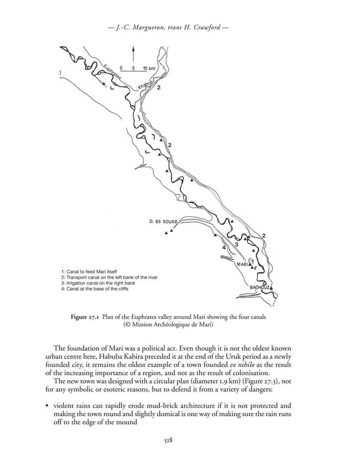
Mari is shown as a dot on a map; however, as well as the city itself, the name refers to a section of the Euphrates valley which runs from Baghouz to Dura Europos, a distance of some 40 km, with Mari at its centre (Figure 27.1). Because of the nature
of the landscape we are able to define its territory with some certainty. Thus:
1. Mari was established to control the crossing of two vital trade routes linking Syria with Babylonia. These are the Euphrates from northwestern Syria and the Khabur River from the east.
2. At the time of the founding of Mari, river transport dominated and it was the waterways which determined the siting of any centre, whether it was regional or interregional.
The actions of the founders of Mari and the site they chose for the new city showed them to be very aware of the type of terrain which is necessary for the creation of an urban centre at the heart of a state.
Bearing this in mind, we see that Mari’s territory covered a section of the Euphrates which is more than 200 km long, from the narrows at Halabiya/Zalabiya in the north to Baghouz to the south. The confluence of the Khabur and the Euphrates gives this section of the river its unique character because it forms an essential outlet not only for the plains around the Khabur river, but also, above all, for the mountains to the north which provided essential raw materials such as wood, stone and minerals which are absent on the plains of South Mesopotamia. Without this background, Mari would never have been founded and this section of the Euphrates would not have played the vital role it did for twelve centuries, from c.3000 BC to c.1800 BC.
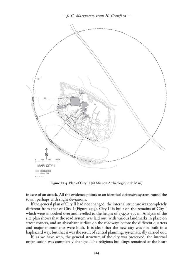
Mari at the heart of this region had an eventful history and excavations show that there were three successive towns, built one on top of the other (Figure 27.2)
THE FIRST TOWN OF MARI: THE FOUNDATION OF MARI
Mari did not develop from a village which grew bigger and bigger until it became a town; all the sondages dug so far indicate that there were no remains below Mari I because the course of the river at that time meant it did not supply water to the site.
517
–– The Kingdom of Mari ––
Figure 27.2 Monuments in the centre of Mari: the Massif Rouge, the Temple of the Lions, the High Terrace of city III, and the quarter of the High Priest. Behind is the Palace with the Enceinte Sacré of City II under the roof and behind that
the ruins of the Palace of City III (© Mission Archéologique de Mari)
Figure 27.3 Schematic plan of Mari showing the main artery of communication running through it (© Mission Archéologique de Mari)
519
––J.-C. Margueron, trans H. Crawford ––
•devastating spring floods led to the building of a dyke of mud to protect the city, with a stone core at its centre to reinforce it.
This wall surrounded a second almost circular enclosure, which in fact was slightly polygonal, with a diameter of 1.3 km. An area of about 300 m separated the two walls and was filled with gardens and craftsmen’s quarters. The interior wall which was only partly excavated, together with one of its gates, was built on a foundation of gypsum blocks; it had a thickness of more than 6 m, a height estimated at between 8 and 10 metres, and was strengthened by towers which projected 2 m beyond the line of the wall.
As yet we know little of the internal organisation of the city; only two sectors have been defined, but they do not include either the administrative centre or that of the temple(s).
There is a final crucial feature. Mari is built on the Holocene terrace and is a long way from the only source of drinkable water, nor could it control the boats using the river from this distance. A canal was dug through the terrace down to the level of the river to link the city to the Euphrates. We do not know where the canal entered the city or at which point it reached the river as it may have been linked to one of the old meanders which are difficult to identify today. It seems likely from the various traces visible that it would have been between 7 and 10 km long.
One can sum up the characteristics of the earliest city of Mari by saying that it was built ex nihilo on the Holocene terrace in order to protect it from the annual flooding of the river to which it was linked by a canal; it was protected by two enclosure walls, one to defend it from exceptionally high floods and the second to defend it from people.
Both C14 dating and thermoluminescense suggest a date for the foundation of the city c.2900 BC.
The hinterland
A huge project to improve the surrounding area was undertaken at the same time as the foundation of the city; the aim was not just to create a new town, but to develop a command centre to control the heavy river traffic which united north and northwest Syria with South Mesopotamia. In order to do this, it had to provide two essentials:
1. Subsistence for a large population when Mari lay in a desert region with an average of 140 mm of rain a year. This is too little for rain-fed agriculture, irrigation is essential to cultivate the Holocene terrace and produce the necessary cereal crops; however, food production can be practised at river level by means of simple shadoufs or lifting devices. Traces of a large irrigation canal found on the Holocene terrace show the choice made by the founders of the city. This canal was fed either by diversion of water from upstream, where the wadi es Souab met the river, or by a dam which held back the spring floods in the same wadi; some traces of the canal were recovered, but they are almost impossible to date.
2. A system of controls so that the city could fulfil its regulatory role over shipping and, eventually, provision itself with goods brought in from afar.
The solution to this problem was not easy; at the beginning of the third millennium water transport by river or canal was by far the easiest, quickest and safest method when
520
–– The Kingdom of Mari ––
travelling downstream. Transport on land by donkey or oxen only became possible after the domestication of the donkey in the fourth millennium and the invention of the wheel at the beginning of the third. The first centuries of the third millennium mark an essential stage in the development of land transport; Mari I is clearly the product of a system of river transport, while the towns of Early Dynastic III, Mari II especially, which represent the second generation of urban settlement, often suggest a much greater reliance on land transport.
River transport has one serious handicap; it uses little energy when travelling downstream, but a great deal hauling the boats upstream against the current which is the only way of going north. The numerous meanders along the river make the route even longer and necessitate frequent changes from one bank to the other, something which is difficult and time-consuming. When traffic is not very heavy such a method is satisfactory. The foundation of Mari, which can only be explained by an expansion of trade, meant this was no longer the case.
Survey along the valley of the Euphrates and that of the Khabur have revealed traces of another canal 120 km long from es-Sijr on the Khabur to the narrows of Baghouz (Figure 27.2); this canal which is dug down as much as 28 m, shortens the journey by about 40 km, ensuring an easier path for haulage and can be navigated throughout the greater part of the year. It is not possible to date this canal by associated objects as it was probably in use for a long time. It is difficult not to attribute it to the founders of Mari, because the canal is the only justification for the position of the city, without it Mari had no raison d’être. It is difficult to see any other justification for the building of an irrigation system here in a particularly inhospitable region if engineers had not been motivated by the need for a large-scale enterprise which assured the growth of the city.
Economic life
Excavation of the various levels of City I illustrates the importance of manufacturing industries in this new city. There is evidence for a wide range of crafts, but it is sometimes difficult to say exactly what they were as the tools and the installations are frequently rather non-specific. One puzzling installation, certainly used for some sort of manufacturing, was originally identified, wrongly, as a type of ‘sit-down’ lavatory: it consisted of a platform of baked bricks with a vertical vent, which divided the platform into two equal parts. All we can say is that it must have been used in some process where the elimination of water was important.
Another small installation looks as though it was designed to collect some liquid after it had been used: it is made up of a low platform surrounded by a raised edge, the whole covered with a layer of bitumen. There is a jar sunk in the centre of the platform, buried up to its neck. Could this be the remains of a dyeing works where surplus dye from the dyeing of cloth was retrieved for future use? This is only a hypothesis.
A workshop for making wheels is a unique find at Mari; the imprint of a wheel, the earliest from Syria, is preserved in the bitumen with which it was covered and even shows how the planks and the hub were put together. In addition, a number of bronze tools were found including a gouge usually associated with the making of this type of object.
521
–– J.-C. Margueron, trans H. Crawford ––
Another very important craft was that of the potter; large numbers of kilns were found in every sector of City I associated with various craft activities and may suggest that potting had a special standing in the range of manufacturing industries in City I.
The most important industry, from the origins of the city onwards, and possibly another major reason for its foundation, was copper metallurgy. The evidence for this comes from materials associated with the manufacturing process, including different types of hearths, fragments of crucibles, and of nozzles from the bellows used. These were found within the city and were sometimes associated with other crafts nearby. For example, a copper workshop was found next to the house of the wheelwright.
Thus Mari found itself on the route which supplied South Mesopotamia with goods originating in the mountains; there can be little doubt that the founders of the city used this situation to bring in substantial revenues. One can conclude that the existence of this first city was closely linked to the manufacturing activities.
The importance of trade is demonstrated by the presence of magnificent lapis lazuli and carnelian beads, a small double chain of gold, Conus shells known to come from the Indian Ocean, large amounts of copper and other minerals which fed the metal industry, and the charcoal for smelting which the river valley did not produce itself.
Stratigraphy
Two areas of excavation (Pec and L) and some sondages provide evidence for the sequence of events in City I. The foundation of the city took place c.3000 BC. A level of earth mixed with ash, about 50–75 cm thick, was brought in and laid down over the whole area. Work with metals began from this first level. The only evidence for the first buildings comes from the Building with Stone Foundations which lay below the Ishtar temple, and from next door to this in Area L, where a homogenous architectural sequence with floors that had been raised twice was found. A serious upheaval, perhaps due to an earthquake, had turned the latest floor upside down preserving a quantity of bones in two different rooms belonging to the same house. These included the remains of two donkeys and of a young individual. The most significant information was the evidence for a break in the stratigraphic sequence. We cannot tell how long it lasted, but long enough for the road to the north to be significantly rerouted.
However, it seems that the most recent level recognised in this area of City I was not the last in this phase; it only marked a level of clearance before a later rebuilding which destroyed all the upper levels in order to establish foundations which were below the final level (of City I). The object of this was to stop the building levels rising too high above the level of the canal. It is not possible to say how thick the levels which have disappeared were, or how long they may have lasted. The level of the new foundations lay at 174.50–175 m.
Architecture
The large Building with Stone Foundations, which lay in the oldest level in the sector later occupied by the Ishtar temple is striking because of its dimensions (more than 32 m x 25 m), and its technical expertise with its foundation of stone blocks more than a metre thick and the size of the rooms, up to 6m wide and 12m long. It must have been an imposing building which shows the skill the earliest builders had in the creation of
522
–– The Kingdom of Mari ––
large-scale architecture. One can easily see this as an administrative building, without being able to say if it belonged to the palace or the temple sectors. The edge of another monument was also recognised in the heart of the city, but it is not possible to say, without enlarging the area excavated, if it was a platform decorated with niches or a wall more that 3 m thick, decorated in the same way.
Domestic architecture of some originality was also studied in the workmen’s quarters; a main rectangular room of 3 x 8 m, stores, and a place for baking bread all stood round a courtyard, apparently without upper floors. This plan which is not specifically urban was repeated half a dozen times, and was also known elsewhere; for example, at Tell Mohamed Arab in the Jazirah.
Conclusion
From its foundation, Mari and the regional improvements associated with it, seems to be an essential pivot between northern Syria, from Assyria to the Mediterranean, and the Sumero-Babylonian region.
CITY II
We do not know how City I ended because in remaking the foundations, the City II builders destroyed the evidence. In the twenty-sixth century (ED III in Mesopotamia) it seems that a new authority at Mari decided on a complete remodelling of the city. Urbanism had developed on the plains of the Khabur and in western Syria (at Ebla for example), and as, since the beginning of the third millennium, transport by donkey caravan or carts was more common, the new settlements were no longer so dependent on the waterways.
The kingdom of Mari, as we have seen, lay at the junction of the Euphrates and the Khabur and ultimately of the Iranian world, the Sumerian world and the AraboPersian Gulf to the south. The internal organisation of the kingdom does not seem to have changed, there is no other new city (Figure 27.2). Only Mari shows us its greatness.
The refounding of Mari and the new urban characteristics
The builders of City II decided to reconstruct the city on the same lines as its predecessor, City I (Figures 27.3 and 27.4), with the same overall plan and they also brought back into use the same water system. No changes were made in either the canal for transport or that for irrigation, they were simply cleaned out; the rebuilding of the city was of necessity accompanied by the refurbishment of the infrastructure throughout the region so that it was once more in working order.
The city kept many of the same characteristics, the same circular external wall measuring 1.9 km in diameter, the same interior one with the rebuilding of the gate into the town, a gate which had already been unearthed in City I, the same layout of roads leading from the centre to the periphery in order to drain off surplus water (Figure 27.3). The external dyke saw the erection on top of its bank of a wall only about 2 m thick whose function remains uncertain. It is too thin to have been defensive and may, perhaps, have been a shield for archers to stand behind as they fired at the enemy
523
–– The Kingdom of Mari ––
of the site while the palace appears as a new feature instead of the metal workshops and domestic housing. Whereas previously the workshops had been dispersed throughout City I, they are now concentrated in certain quarters as is demonstrated in the souk area, and in the space between the two walls. Some temples, such as that of Ishtar, are built outside the sacred precinct in the centre of the city itself.
The drainage system which collected rainwater was quite complex serving all the quarters and implies the presence of a civic authority, perhaps one in each quarter. The reservoirs of this period have not yet been discovered.
A strip of buildings about 700 m long was excavated from the western ramparts, to the eastern sector of houses, past the Ishtar temple, the souk, the palace and the religious sector, making Mari without doubt the best-known city of the third millennium.
Stratigraphy
City II survived for a relatively short time, about two hundred years, and the rebuilding of the infrastructure at a later date has not been conducive to the preservation of a stratigraphic sequence. Overall, there is only one identifiable architectural level. The palace which survived for the whole of this short period is a single building with evidence for three phases of occupation, called P3, the oldest, then P2 and P1 which ended in a huge fire. A partial reconstruction (P0) marks the transition to City III. Nor is there stratigraphic evidence in the temples of Ishtar, Ninni-Zaza, Ishtarat and Ninhursag each of which has only one or two floors. The houses only have one level of occupation, while the souk has two.
The palace
Incompletely excavated, the palace of City II is an exceptional building (Figure 27.5) because of its size (it is the biggest of all the known Early Dynastic palaces), its state of preservation with walls standing 5 or 6 m high, the variety of the different sectors, the presence of a temple within it (another unique find) and the ingenuity and novelty of the solutions used to solve the problems of construction. Three phases have been identified, some better understood than others:
1. Phase P3 has been recognised in the middle of the Enceinte Sacrée, the temple, in Area 4 and in the gateway to the palace.
2. P2 has yielded the complete plan of the Enceinte Sacrée which is the biggest temple in City II: it has a central space 16 m long surrounded by rooms; in the north, the entry to Area 4 was found and to the south a fine room 8 m long which, with an annex to the east in which there is a low podium, forms one side of the central space. A passage running all around it is highly distinctive for the religious sector and provided a suitably diffused light to the central covered spaces which only received direct light when the sun was at its zenith. The rest of Palace 2 is still to be uncovered. Only the religious part of the building has been identified.
3. With P1 the eastern part of the the palace is more or less complete so we can see that it had non-religious functions as well, although the importance of the sacred sector continues. One can identify domestic quarters and workshop areas. However,
525
–– J.-C. Margueron, trans H. Crawford ––
Figure 27.5 Reconstruction of Mari (Courtesy of the Louvre)
its royal functions cannot be identified with complete certainty, for, at this period, they do not show themselves in specific and clearly identifiable architectural features. One of the texts found talks of the Great House, that is, the palace, which suggests that the characteristics of a palace will probably be found in the rooms of the western sector which has not yet been excavated.
This level ended in a violent fire. In excavations recently carried out to the west of the entrance, a number of seal impressions of king Ishqui-Mari (formerly known as LamgiMari) were found among the ashes. His name has been known since the earliest excavations, but his place in the chronology of the site was unclear. This discovery fixes the time of the destruction and the name of the king who submitted, but it does not tell us the name of the conqueror. Phase 0 came immediately after the destruction of palace 1; there was a levelling of the burnt rubble and this and the burnt walls were covered with a layer of earth. The Enceinte Sacrée and Area 4 were refurbished and additional jambs were inserted into the doorways to make the doors smaller and to lighten the load on them. A monumental room which might have acted as a Throne Room was built with a double row of square pillars of unbaked mud brick decorated with fluting.
Level P0 was not occupied for long and another new palace was soon built.
Few objects were found in the ruins of the palace, except for large numbers of seal impressions in Palace 1, which are important for the study of history and iconography. The Treasure Jar, which was a foundation deposit below P0, contained a superb pendant in the form of a lion-headed eagle, a fine collection of cylinder seals and a lapis-lazuli bead inscribed with the name of Mesannipadda king of Ur.
526
–– The Kingdom of Mari ––
The temples
Seven temples are known dedicated respectively to Ishtar, Ninni-zaza, Ishtarat, Ninhursag and Shamash, or to unknown deities (the Enceinte Sacrée and the temple of the Massif Rouge) (Figures 27.2 and 27.4), all except the first were located in the heart of the city. The temple tower of the Massif Rouge had an almost square plan with an internal staircase giving access to a terrace, the emphasis being on a vertical progression, something characteristic of the Syrian world. The other temples belong to a group typical of Mari with a simple plan of which the Enceinte Sacrée seems to be the archetype. The plan consists of a central space more or less square, which gives access on one or other of its sides to a large room. This extends the full length of one side and has a low podium at one end which must have supported either a divine statue or the symbols of the god. The central space is surrounded with other rooms and this basic plan can be added to in any direction. Access from the exterior was to the central space which then led the faithful to the large shrine.
Amongst the sacred buildings we should again mention the Massif Rouge with its high terrace, which undoubtedly played an important role as a place of sacrifice for all the temples of Mari.
Between the Enceinte Sacrée and the Massif Rouge there was a sector with buildings of different degrees of importance, to judge from the network of streets; this has proved to be the administrative centre of the High Priest (Figure 27.2) which is similar to the contemporary Walled Quarter at Khafaje.
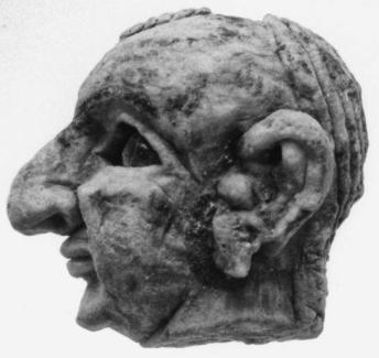
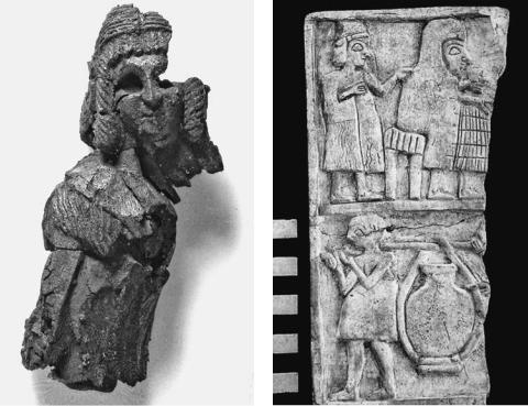
It is in these temples that the exceptional series of statues were found – Ebih-Il, Ur-Nanshe, Idi-Narum, Iku-Shamagan, l’Homme de Mari (Figure 27.6) – as well as many fragments of shell mosaics, a speciality of Mari’s.
Figure 27.6
The Man of Mari (©
Mission Archéologique
de Mari)
527
–– J.-C. Margueron, trans H. Crawford ––
The houses
The houses were planned to accommodate the needs of an urban family. On the ground floor was a central covered area with rooms opening off it for cooking, washing, and a stable for a donkey; the reception room and living quarters were on the first floor and also opened off the central space which provided air and light.
The history of City II and its end
City II lasted about two hundred years. Some echoes of its history are found in the Ebla texts which give us the names of kings and illustrate some of their problems.
A fire brought City II to an end apparently after the victory of Naram-Sin over Ishqi-Mari, the last king whose seal impressions were found in the burnt level of P1.
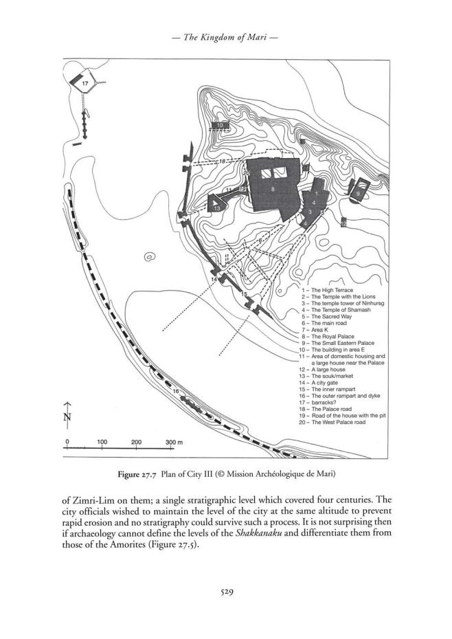
MARI CITY III
The rebirth of Mari
The destruction of City II was almost total, but the decision to rebuild it was quickly taken. In reconstructing the palace (Figure 27.7), Naram-Sin killed two birds with one stone: he restored political power as well as putting the great sanctuary in the palace back in working order. Thus the citadel took up its former role and the king could again exercise his authority, even if it was by proxy. This is why Naram-Sin appointed a governor or Shakkanaku called Ididish to represent him.
The rapid dissolution of the Agade empire changed the original situation. The weakness of the centre allowed the governor of Mari to assert his authority and to give the city back its role as the pivot between Syria and Babylonia. The title of Shakkanaku now referred to the supreme authority in Mari which re-established its position as the capital of northern Mesopotamia. The status quo was established for several centuries with a polarisation of the Syro-Mesopotamian world which reflected its true nature.
Mari shone brightly for a period of three or four centuries. The rarity of texts covering this period makes it difficult to write its history and hides the brilliance indicated by the archaeological evidence.
The stratigraphic problem: the difficulty of distinguishing between the Amorite city and that of the Shakkanaku
We have seen that the people who rebuilt City II began by lowering the levels across the site to an average of 4 m above the plain, above which the compartmented foundations were built. This time the reconstruction took place on top of the destruction level at an absolute height of 179 m; in some areas, the destruction level was smoothed over, but without touching the burnt debris. Because of this there was not a uniform base for rebuilding across the site, but the drainage system was respected.
In some places one can see at least two or three thick levels in the stratigraphy (chantier F), but in others we see only one architectural level with foundations more than a metre deep. In chantier K, at the base of the foundations an Agade tomb was found, while below the floor of the house 1 meter above it were bricks with the name
528
–– J.-C. Margueron, trans H. Crawford ––
THE TIME OF THE SHAKKANAKKU
The reconstruction
Phase P0 of the palace of City II, restored immediately after the destruction of P1, was quickly abandoned and a new palace was erected in its place. However, only a few fragmentary remains of this period survive and it is not possible to reconstruct the palace of the early Shakkanakku.
In the sacred area we can follow the evolution of the buildings thanks to the foundation deposits below the various monuments. The sahuru, or foundation inscriptions, and the temple of Ninhursag were the work of Nûr-Mêr, but it was Ishtup-Ilum who, when he built the Temple of the Lions, also carried out work on the grand scale on the High Terrace, which was closely associated with the temple, isolating these new constructions by layers of pebbles.
The ramparts, essential for the security of the city, were rebuilt and strengthened. The outer dyke, once transformed into a defensive wall, was progressively enlarged to about 10 m in width. This structure, which previously had been intended merely to slow down an enemy, now became a particularly strong line of defence. The inner rampart was also completely rebuilt with a deep foundation trench in which was built a wall some 10 m thick. The city was thus provided with a double line of defences and if one wants to assess the power of the city under the Shakkanakku, this alone is enough to demonstrate it.
It is remarkable that each of the two restorations followed the original lines of both the inner and the outer wall. Even if the interior of the city changed, its outline remained the same; the topographic and climatic factors which determined the original position of the city certainly remained the same, but reason suggests that the original area, once defined and dedicated to a god, could not be altered.
The transformation of the religious sector
Some major changes took place in the religious sector. It is not very clear what became of the Massif Rouge. It was still in use at the beginning of the period with a sort of rebuilding and possibly an additional terrace, but we do not know if it was still in use in the Amorite period or whether by then another temple stood above it. Nothing is very clear. The eastern limit of the sacred area remains uncertain for at least part of City III.
Towards the south, the Sacred Way now forms the boundary of the temple area after the temples of Ninni-zaza and Ishtarat have disappeared, and above the Ninhursag temple of the second city there rose a newcomer, the temple tower of Ninhursag, with a Levantine plan, here at the eastern edge of its distribution. It has been identified thanks to the foundation deposits of its builder, Nûr-Mêr; its distinctive plan, similar to that of the temple tower of the Massif Rouge, indicates a very different cult because it is oriented towards the infinite heavens and not towards a face-to-face meeting with the divinity.
The major project, probably undertaken by Ishtup-Ilum, was the building of a new High Terrace (Figures 27.2 and 27.7), an essential monument because it was here that sacrifices took place. Originally it was rectangular, about 40 m by 20 m in area, its long
530
–– The Kingdom of Mari ––
axis oriented west/east with, on its north face a long ramp which stretched for 30 m and was reinforced by three long walls which diverged slightly. This huge ramp allowed the sacrificial animals to reach the top of the terrace without too much difficulty.
The unique feature of this High Place for sacrifice is that it is closely associated with the big Temple of the Lions (Figures 27.2 and 27.7), rebuilt by the king Ishtup-Ilum, as is shown by the foundation deposits placed all along its south face. It is the biggest of the City III temples (about 36 m x 20 m), erected on a terrace almost 2 m high, something which gave it excellent stability, with walls 5 m thick; it belongs to a series of long rectangular temples also called temples in antis. A terrace enclosed by a boundary wall gave access to the east door, a very simple plan: the door, decorated with palm trunks, gave onto a large rectangular room with a long bench on its north wall and a podium attached to the shorter west wall. This big room seems to have been a Sacred place – it not impossible that a mobile altar served as a place for offerings – while the altar against the west wall was the Holy of Holies. Two doors, one on either side of the main altar, gave access to two small rooms, an unusual plan. Immediately on the left after the entrance, two bronze lion protomes, standing on two platforms of different heights, sprang from the wall.
This temple stood in an imposing manner in the heart of the city, but we have to imagine its whole mass to understand its impact. The thickness of the socle built for it implies that there were heavy pressures on it. Bearing this and the thickness of the temple walls (around 5 m) in mind, we have to reconstruct it as having a height of not less than 10 m, which would also bring it into line with the High Terrace with which it was closely associated. That is to say, that the temple must have had at least two levels and one of the two small rooms found at its base probably held the staircase which joined the two levels and gave access to the High Terrace.
The close relationship between the terrace and the temple shows their real significance; in City III they form a single unit which was the religious centre of the city, one which was apparently under the rule of the high priest of the Lion Temple, who distributed sacrifices to all the other temples thus maintaining the hierarchy of the gods. This exceptional sanctuary was dedicated, according to the foundation deposits to the King of the Land.
The palaces
The palace built at the beginning of the period of the Shakkanakku had disappeared leaving hardly any trace. It was succeeded c.2000 BC by the Royal Palace excavated by André Parrot, which, thanks to some 15,000 tablets, has given us incomparable evidence for the period of the Amorite dynasties. However, it was constructed much earlier than this and its history covers about two and half centuries, going back to the period of the Shakkanakku and not just to that of Zimri-Lim, the last king.
The beginnings of the palace date back to the time of the Shakkanakku/Ur III and we have to understand the changes which took place if we are to be able to determine which characteristics belonged to each period and how the building evolved. These changes often indicate a change in thought and in ritual pracrice. If the chapel of Ishtar and the chapel with the paintings (Room 132) survive unchanged throughout the life of the palace, other parts were constructed more recently like the king’s appartments built at a time when Shamsi-Adad was in charge.
531
–– J.-C. Margueron, trans H. Crawford ––
It is not always easy to identify the remains of the earliest palace. We cannot show the overall plan or how it functioned, but we know that the new building of HanunDagan – a Shakkanakku prince known from a list of shakkanakku and from the foundation inscriptions of the palace – covered the same area as the palace of City II. This sole fact allows us to demonstrate the scale of the plan. Finally, we have to ask why the Great Royal Palace replaced the palace of the Shakkanakku so quickly; was it wear and tear, a violent destruction or a different concept of what a palace should be? We do not know. The floors of the new palace were found below the level of those of the old one so that, once again, the occupation levels have been dug out.
Indications of the wealth and power of the city at the time of the Shakkanakku
From the archaeological evidence, the scale and size of the buildings we have discussed demonstrate the power of the city, supported by its economic life. To these buildings we have to add the Small Eastern Palace, domestic housing and the constant reinforcing of the defensive system.
The tombs found below some of these houses provide excellent evidence for the lives of the people. The funerary goods are very rich at this period; jewellery is frequent and varied and the large quantities of bronze items which accompanied the dead are exceptional. We find weapons, tools and objects from everyday life.
MARI IN THE AMORITE PERIOD
There is no kinglist from the time of City III to show us the order in which the Shakkanakku reigned and this remains unclear especially for the nineteenth century. Things are clearer for the Amorite dynasty which covers about fifty years from c.1810 to 1760.
The kings and their history
The relationship of the Shakkanakku to the Amorite kings is still unknown. The dynastic sequence begins at the end of the nineteenth century with Yaggid-Lim, followed by Jahdun-Lim who is the first known king of the dynasty and who, in turn, was succeeded by Sumu-Yamam; then about 1800 BC Shamsi-Adad, king of upper Mesopotamia, siezed Mari and installed his son Yasmah-addu as viceroy. He was unable to hold it after the death of his father. Zimri-Lim then succeeded (c.1775) in snatching back the throne until Hammurabi of Babylon destroyed the kingdom of Mari in 1760/1759.
Thanks to the palace archives the reign of Zimri-Lim is quite well documented, much better than the reigns of Iasmah-Addu and Iahdun-Lim. The reigns of the latter and of Zimri-Lim were marked by attempts to control the region of the Khabur. On the administrative side there seems, from time to time, to have been a desire to imitate Babylon. The period was not one of major building, but of meticulous refurbishment.
The glacis and the outer wall
The Shakkanakku had, by stages, greatly reinforced the outer defences by means of a wall about 10 m thick; another innovation allows us to say that these changes were
532
–– The Kingdom of Mari ––
certainly a response to new methods of siege. They laid down an embankment of earth and stones along the inside of the wall, using a total of 308,000 cubic metres of material, a huge task. A rough calculation suggests that three million donkey journeys carrying 100 kg each, would have been necessary between the quarry and the rampart which are about 10–15 km apart. If 1,000 donkeys worked every day, it would have needed 3,000 working days (more than eight years) to complete this glacis.
Iahdun-Lim may have built it, but it is impossible to be certain. The gravel is the secret weapon, it is easy to dig a tunnel through a masonry wall and so overcome the obstacle, but it is not possible to use the same technique in gravel which will just collapse as fast as it is dug, making the work of sappers impossible. This new defence allows us to deduce what siege warfare could achieve and was in response to the appearance of siege engines.
The palace
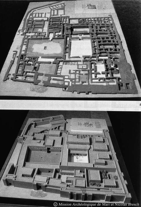
The destruction of the palace by Hammurabi has given us, by virtue of the archaeological and the epigraphic evidence, a snapshot of a monument which is typical of a palace-dominated civilization at the end of its life, of all the administrative and economic activities which took place within it, of the way of life of its inhabitants, the rituals of kingship, and of the palace’s position at the heart of the economic system: it is unique evidence from a building which was the keystone of the palatial system (Figure 27.8).
With an area of 2.5 ha, the palace is part of a group of large monuments, without however being exceptional; because of erosion its southwestern corner has disappeared. The original plan was extended twice, once on its eastern edge to which the stables provided an entrance from the north, the other on the south where many storerooms were set up, also linked to the stables.
Two major courtyards formed the main foci of the building. In the east was the court with the Painted Chapel (Room 131 or sector B) and, in the west, the Court of the Palms (room 106 or sector M), linked to court 131 in its northwest corner. The palace is thus formed of two distinct areas. The first, the eastern half, stretches from the main entrance, which was under the supervision and control of an Intendant whose quarters lay in the northeast corner (sector C) of the palace. His rooms opened onto the court of the Painted Chapel (131), this was the biggest of all the palace courts and had a central cistern to provide water for the inhabitants; it was also the pivot for the major routes through the palace, to the chapels and to the stores to the south. The Painted Chapel, containing the oldest paintings, was dedicated to Ishtar and opened onto the court.
The northeast angle of the court gave access to the rest of the palace.
The second part of the palace was more secluded and was protected by the first. It was made up of three big sectors: in the centre the official area (M) (consisting of the Court of the Palms), the papuhum or entrance hall and the Throne Room (rooms 106, 64 and 65). This tripartite arrangement was designed in accordance with the ideology of the time to enhance the status of the king. The suite was superbly decorated; the court was covered with white plaster ornamented with red and blue bands while the west wall of the court, which gave access to the Throne Room was painted with a mural depicting the Investiture of the King and sacrificial processions. Facing the door of the
533
–– J.-C. Margueron, trans H. Crawford ––
Figure 27.8 Reconstruction and plan of the palace of Zimri-Lim (© Mission Archéologique de Mari and Nicolas Bresch)
534
–– The Kingdom of Mari ––
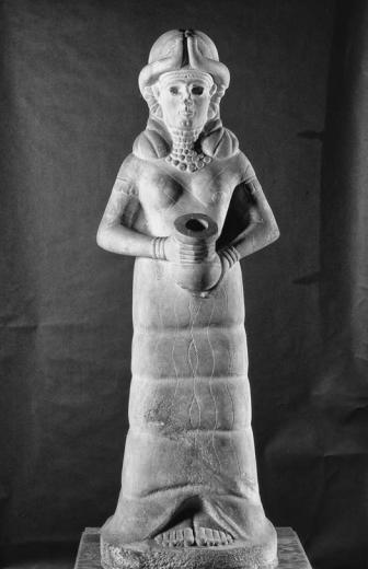
papuhum stood the statue of the Goddess with the Flowing Waters (Figure 27.9). Then came the majestic Throne Room (12 x 25 m and 12 m high) with a throne dais at one end and at the other a raised platform on which stood statues of some of the royal ancestors. The one of Ishtup-Ilum was found at the foot of the flight of steps leading up to it.
The king’s own quarters lay round the Throne Room as if to demonstrate all the aspects of royal power: his living quarters were on the first floor richly decorated with wall painting; there was accommodation for slaves (G), the kitchen area (O), then the administrative hall (P) with offices and archives on the first floor. Finally, the Women’s quarters lay in the northwest corner, closely linked to the official quarter.
Thus we have a unified group of rooms all glorifying the functions of the king. Together with the living quarters of the king and of the women, each sector of the palace had a functional purpose, a religious quarter, rooms devoted to the storage of
Figure 27.9
The goddess with the flowing vase (Aleppo Museum, Syria)
535
–– J.-C. Margueron, trans H. Crawford ––
goods, and a command post at the entrance. The palace was like a highly complex organism at the heart of the kingdom. It sheltered the king, his servants and his women; here he administered his kingdom and exercised his power; he dealt with affairs of state, economic matters, manufacturing, storage, the taking of decisions; workshops lay out of the palace, outside in the town and elsewhere in the kingdom. The importance of the storage depots lay in the fact that they provisioned the palace itself while goods such as food, oil and clothing were redistributed as payment to the servants. Here the king received the homage of his servants and met with visiting dignitaries, sometimes from far away; here he gave banquets, even if there are other places where this could have happened. Here ritual ceremonies closely tied to the exercise of power took place, power which was founded on the Kispum ritual in honour of dead kings from whom the legitimacy of the dynasty came.
The temples
Under the Amorite dynasty the temple of the Lions and the temple of Ninhursag were only slightly modified, while the temple of Shamash was transformed. King IahdunLim decided to rebuild the temple of Shamash and his rebuilding ensured that the very old plan survived till the fall of Mari, something which is shown by the foundation nails of City II which he carefully replaced in the new sanctuary beside his own. These took the form of nine baked bricks inscribed with a long text of selfglorification.
Alongside this apparent archaism is an important innovation: a high terrace for the cult was built against the northwest edge of the temple in the form of a terrace 15.30 m x 14.30 m in size, standing 1.70 m high when it was uncovered. Three faces were decorated with niches and the fourth was occupied by a staircase. This terrace, known as the Massif à Redans, was integrated with the temple by a system of interconnections at ground floor level and probably by another at the higher level. Perhaps it was an observatory for studying the sky and the stars, or perhaps for bird watching. There is a new aspect to this terrace, it was not used by all the temples but only by one. This was new at Mari, but there are examples in other places at the same time, at Tell Rimah in Assyria for example and at Alalakh in Syria.
THE END OF MARI
Mari vanished in 1760 according to the middle chronology, or perhaps about a century later according to H. Gasche (Gasche et al. 1998). Hammurabi of Babylon conquered successively Elam, Eshnunna and Larsa before turning back to vanquish Mari in turn. Babylonian troops were installed at Mari and Hammurabi’s servants took the time to sort the archives and then carried off as booty everything in the way of riches or art objects in the city. Finally, they set fire to all the monuments, the palace and the temples, before knocking down the walls. Although there is no direct evidence, we can assume that most of the population were led away into exile.
Mari ceased to exist, not only because of a military disaster, she had been reborn after several such events, but also because the parameters of economic life had changed (movement of the centres of decision-making in the north and at the foot of the mountains). Changes too in the means of transport (overland transport, caravans and
536
–– The Kingdom of Mari ––
chariots at the expense of water transport) meant that the valley of the Euphrates was no longer a crucial axis in the Middle Eastern world.
Bearing in mind the ideas which accompanied the rediscovery of the Sumer over the last 150 years, we have to ask if Mari belonged to the Sumerian world or not. This world saw the beginning of the urban era in the south of Mesopotamia from about the middle of the fourth millennium. It was thought, naturally enough, that the urban centres like Uruk, which emerged in the delta of the Tigris and Euphrates, then spread along the rivers. Sixty years ago it was possible to write that Mari was a beacon of Sumerian civilisation in western lands without realising that Mari could not have existed without its own network of resources and certainly could not be regarded as the result of colonisation. During the third millennium, the short-lived supremacy of first Agade and then of Ur, left Mari on the margins of their world. The expansion of Hammurabi’s power in the eighteenth century appeared to follow the same pattern. This does not take into account the geography of the Mesopotamian basin, split in to a northern and a southern region separated by Babylonia; these regions are linked together by two major routes – one towards the Gulf and southeast Asia and the second towards the Mediterranean and Anatolia. The northern regions, which above all furnished essential raw materials to both the centre and the south, could not have been simply an offshoot of the south. Even if some traits (the round plan and the canals for example) link the city of Mari to Sumer, its position, the originality of its architecture and its art show Mari to have been the dominant creative centre in north Mesopotamia.
Finally, Mari is a wonderful example of the birth of a city in a very specific geographic, economic and human situation. Because men saw the advantages of a geographic position which allowed it to control an extremely profitable exchange network, they engaged in a bold development in a harsh geographic setting. As long as the conditions remained the same, Mari flourished; when conditions changed, she disappeared – an astonishing historical lesson.
BIBLIOGRAPHY
Gasche, H., Armstrong, J.A. and Cole, S.W. 1998. Dating the Fall of Babylon. Ghent and Chicago: University of Ghent and Oriental Institute.
Geyer, B. and Monchambert, J.-Y. 2003. La basse vallée de l’Euphrate syrien du Néolithique à l’avènement de l’Islam, 2 vol., BAH 166. Beyrouth: IFPO.
Margueron, J.-C. 2002. Le Temple de Shamash de Iahdun-Lim à Mari. In Of Pots and Plans: Papers presented to David Oates. Al-Gailani Werr et al. (eds). London: Nabu Publications.
——2004. Mari, métropole de l’Euphrate aux IIIe et IIe millénaires. Paris: Picard.
——2007. Mari et la chronologie: acquisitions récentes et problèmes. In From Relative Chronology
to Absolute Chronology: The Second Millenium BC in Syria-Palestine, P. Matthiae, F. Pinnock, L. Nigro, L. Peyronel (eds), pp. 285–301. Rome.
537
CHAPTER TWENTY-EIGHT
EBL A
Frances Pinnock
INTRODUCTION
The excavations at Tell Mardikh/Ebla started in 1964 and are still going on under the direction of P. Matthiae. After forty-seven years of systematic exploration, it is possible to delineate the urban plan of the Old Syrian town of Middle Bronze I–II
(c.1900–1600 BC) clearly. The city covers approximately 56 hectares in area. This area includes the royal residence and Ishtar’s dynastic temple on the Acropolis; the belt of public, cult and palatial buildings at the feet of the citadel; the quarters of private houses, and the imposing earthen ramparts of the fortifications. These have a system of postern gates and of forts and fortresses built on top (Matthiae 2010a: 226–278). The extended excavations made at the beginning of the second millennium BC, on the other hand, almost completely removed the levels of the previous late Early Syrian period (= Early Bronze IVB, c.2200–2000 BC), and badly damaged the oldest layers of the mature Early Syrian period (= Early Bronze IVA) (Matthiae 2010a: 195).
We have thus to consider the whole late Early Syrian town completely lost, with the exception of one section of the city wall, included in the Old Syrian rampart in the northeast region, close to the Aleppo Gate (Pinnock 2009: 69). On the other hand, notwithstanding important gaps, the Early Bronze IVA town is preserved in limited parts of the Lower Town, but most of all in a peripheral, yet quite large and functionally meaningful sector of the Royal Palace, probably called SA.ZAxki in the texts of the State Archives found inside the building (Matthiae 2008a: 42). Two other important areas, located respectively on the Acropolis and in the Lower Town, preserved most of two cult buildings, which probably were the two main sanctuaries of the Early Syrian town.
The town, which is one of the main examples of secondary urban development in north inner Syria, developed, apparently without important antecedents, from c.2600 BC (Matthiae 2003, 2010a: 41), with a very important phase between 2400 and 2300 BC in Early Bronze IVA, a phase we may now call Age of the State Archives, because of the presence of an astounding number of cuneiform documents of the palace central administration. These are throwing an unexpected light on the social, economic, and political life of the town. Ebla was destroyed, at the end of this period, either by Sargon of Akkad, who boasts of the conquer of Mari, Yarmuti, and Ebla, in a votive inscriptions of his, dedicated in the Ekur temple at Nippur (Matthiae 2008a: 24), or as a consequence of the political instability created in the region by the Mesopotamian king’s
538
–– Ebla ––
campaigns towards the Upper Sea, as they called the Mediterranean (Matthiae 1989a,
2008a: 108).
The quality and quantity of data offered by the texts of the State Archives, concerning the last fifty years of the town, and the remains of architecture, artistic and material culture, allow us to fill more than one gap in the reconstruction of the history of north inner Syria. They also allow us to draw a more precise picture of the history of Syria, and in particular to focus on the relations of reciprocal contact and influence between Syria and southern Mesopotamia. As a consequence, it is also possible to define how and when the development of the cultures of northern Syria and northern Mesopotamia took place. They had to interact with two regions, north inner Syria and southern Mesopotamia and these two areas look increasingly like the joint poles for the elaboration of the ideology of kingship, for the construction of economic and political power and for the creation of architectural and artistic models.
URBAN PATTERN
If the short section of mud-brick wall, 6.00 m thick (Figure 28.1), in which a few sherds of pottery dating from the Early Bronze IVB period were found, reproduces, as seems quite likely, the line of the previous Early Bronze IVA wall, we could be led to believe that, in the mature Early Syrian period, the town covered an area quite similar to that of the Old Syrian period. This is also suggested by the distribution of several architectural remains and ceramic fragments corresponding with almost every building of Middle Bronze I–II thus far brought to light. The Acropolis was the seat of central
Figure 28.1 The northeast rampart of Old Syrian Ebla, including a section of the Early Bronze IVB mud-brick wall (© Missione Archeologica Italiana in Siria)
539
–– Frances Pinnock ––
power, with the Royal Palace, a classic multi-function building built up of juxtaposed units with different functions. In the final phase of the period, an important temple was built on the Acropolis, while a second temple was located in the Lower Town, close to the town wall.
From the textual evidence it seems quite likely that the town was divided into four quarters, so it is also possible that the four gates opening in the Old Syrian rampart reproduce the location of gates to the town of the Early Syrian period, of which, however, nothing is preserved under the later ruins.
CULT ARCHITECTURE
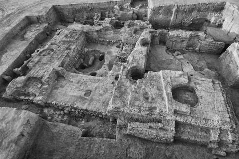
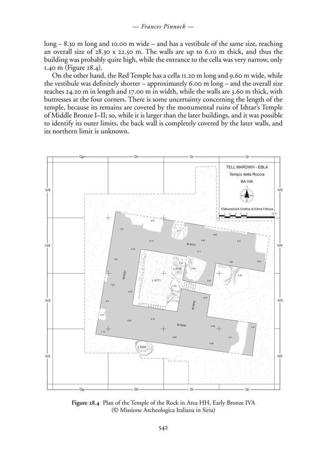
In the most recent years of the archaeological exploration of Ebla, two cult areas were brought to light: one in the southeast of the Lower Town, and one on the northwest edge of the Acropolis. Both were used as cult areas for a long time, between Early Bronze IVA and Middle Bronze II. As concerns the State Archives Age, the temple in the southeast of the Lower Town is probably the older one. It is called Temple of the Rock because the rock layer, on which the temple was built, was left bare inside the cella (Figure 28.2): here a large semi-circular cavity was served by three wells, probably leading to sources of underground water (Matthiae 2007, 2008b, 2009a; Pinnock forthcoming).
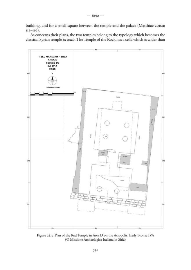
On the other hand, the second temple, called the Red Temple because of the very strong colour of its bricks (Figure 28.3), was probably built by the end of the State Archives Age, on the northwest edge of the Acropolis, over the remains of sectors of the Royal Palace G: these had been abandoned and razed in order to create a space for the
Figure 28.2 The Temple of the Rock in Area HH, Early Bronze IVA
(© Missione Archeologica Italiana in Siria)
540
–– Ebla ––
As the relative chronology of the two main Eblaic temples of the State Archives Age is clear, it is possible to maintain that the change from the in antis temple with a wide cella to the temple with a long cella took place during the same mature Early Syrian period, Early Bronze IVA. In the late Early Syrian period, Early Bronze IVB, two new cult buildings were erected over the remains of the more monumental temples of the State Archives Age: over the Temple of the Rock, Temple HH4 features the final appearance of the plan with a long cella – here 8.10 m long and 6.10 m large – but the vestibule is deeper than usually happens in the classical Syrian temple in antis. In Area D on the Acropolis, on the contrary, a building, quite likely of Early Bronze IVB, is squashed between the Red Temple of Early Bronze IVA and Ishtar’s Temple of Middle Bronze I–II; the plan is therefore incomplete, and could be the first example of a tripartite temple, in a specimen which certainly was not very monumental. The tripartite temple in antis was to become the classic plan for sanctuaries closely related to palaces, or connected with royal ideology.
The Temple of the Rock and the Red Temple, therefore, are two buildings of similar monumental aspect. The first one was probably related to the presence of underground water, and thus, perhaps with a foundation myth of the town; it was built very close to the town walls, and quite likely, also to a city gate. The second temple was closely connected to the Royal Palace, and, in fact, as already maintained, the space left between temple and palace was very narrow, and the Palace did not have a true perimeter wall in that area. These elements, with the careful analysis of written documents like the Ritual of Kingship (Fronzaroli 1993), led P. Matthiae to identify in the two sanctuaries two temples dedicated to the main deity of the Early Syrian Eblaic pantheon, namely Kura, a god who can be considered similar to Enki in the Mesopotamian world. In fact, in the Ritual text, they mention Kura’s Temple in the Lower Town, which the queen enters, after spending one night outside the town: here the queen wears the ceremonial dress, before starting the ritual for the renewal of kingship. The complex ceremony, which lasted several days, ends in Kura’s Temple in the SA.ZAxki, a term, as already suggested, probably indicating the Royal Palace itself. At the end of the ritual, the royal couple – representation on earth of the divine couple of Kura and Barama – regained possession of their prerogatives, as is indicated by the sentence ‘the king and queen provide, they do provide’, as opposed to the sentence ‘the king and queen provide, they do not provide’ previously employed during the development of their complex journey, touching divine temples and royal mausolea in the territory of Ebla, outside the town.
The Ebla temples belong to an architectural tradition which probably started in Upper Mesopotamia at the beginning of the Early Syrian period, with the specimens in particular of Halawa (Building I), and Tell Khuera (Aussenbau, Steinbau, and Nordtempel), featuring a clear break from the tradition of the Uruk colonies of south Mesopotamia (Pinnock forthcoming). In these buildings, the plan with long cella prevails. In inner Syria, the Syrian temple in antis is represented by the two Eblaic specimens, and also by the temple of er-Rawda, and by the Aleppo temple, where, on the contrary, the cella is mainly of the wide type. This typology will be gradually abandoned during Early Bronze IVB, and the typology with long cella will become the rule in Middle Bronze I–II. A similar development may also be singled out at Byblos, where the Chapelle Orientale has a wide cella, while the antecedent of the Obelisk Temple in Early Bronze IVB features a long cella (Pinnock 2007).
543
–– Frances Pinnock ––
PALACE ARCHITECTURE
Palace architecture is represented in the topmost level by the Royal Palace G, whose oldest core was probably founded in 2500 BC, and known to us, though incompletely, in the shape it had between 2400 and 2300 BC, when it was destroyed by Sargon of Akkad (Matthiae 2010a: 71–72).
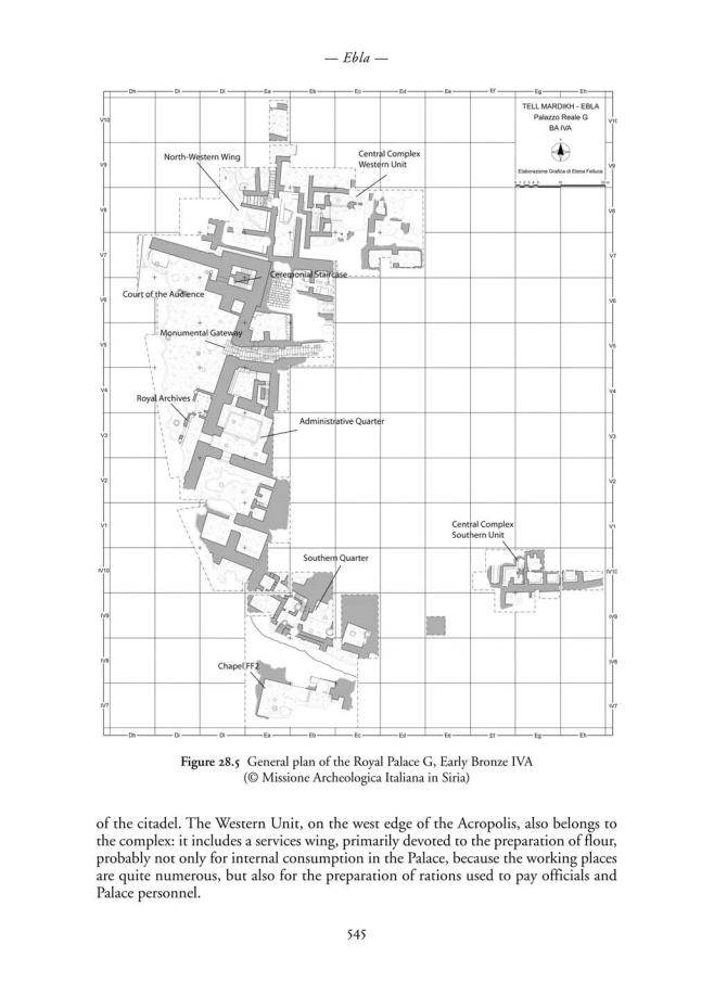
The building, with its annexes probably occupied the whole area of the Acropolis of Tell Mardikh, approximately 20,000/30,000 square metres in area, and this was probably the complex called SA.ZAxki in the texts of the State Archives. Of this wide area, only a part was recovered in the archaeological exploration, mostly in the parts where the building was protected by collapses along the west border of the central hillock of the site, for an overall surface of 4,700 square metres, corresponding to 17 to 23 per cent of the total extent of the building.
The Palace included several juxtaposed units (Figure 28.5), and among those already brought to light, the Court of Audience stands out: this was a large open space, outside the building proper, where the king gave audience, or rather took part in public ceremonies. Probably half of the original space of the Court is preserved, which was probably originally a rectangular square, with porches along three sides at least, and the dais for the royal throne built against the short north wall of the court. Soundings made west of the preserved part of the court revealed that the Court of Audience was not flanked there by other units of the Royal Palace, so the Court was a peculiar space, in part belonging to the Palace, and in part outside it, a kind of hinge between palace and town, and, at the same time, a monumental setting for royal ceremonies (Matthiae
1976a, 1976b, 1978).
Three main entrances and a smaller one opened through the Court façades. The three main entrances all opened onto the east façade. From south to north there is the door to the Administrative Quarter, the Monumental Stairway leading to the central core of the Palace, and the Ceremonial Staircase, in the northeast tower, leading to the private residence, probably located at a different level, or on a different floor. A smaller door opened beside the royal dais, and led to a sector probably reserved for the queen.
The Administrative Quarter certainly was the core sector of the Palace life, and therefore of the whole town. It was called this because of the presence of the main room of the State Archives, and because it contained, particularly in the Trapezoidal Store, valuable artefacts, and precious imported stones (Figure 28.6), among which lapis lazuli and rock crystal are particularly noteworthy (Pinnock 1992, 1986). Moreover, the enlargement of the excavations showed that the Quarter, which lay east of the Court of Audience, stretched around a small court with a porch on all four sides and a large hall that opened to the south. The hall was divided in aisles by a line of columns, and two small storerooms opened behind it, which still contained the remains of objects of high-quality palace manufacture (Figure 28.7) and several heaps of raw lapis lazuli, originally kept inside cloth bags, whose impression was still visible in the soil (Pinnock 2006b). The hall with columns is certainly a Throne Room, where the king held private audiences, probably closely related with the acquisition of raw materials, with special regard for precious imported goods, which were afterwards kept in the storerooms, accessible only through the Throne Room.
The so-called Central Complex was the main core of the Palace on the Acropolis: some storerooms for pottery vases and food supplies were identified on the south slope
544
–– Frances Pinnock ––
|
Figure 28.7 |
|
Steatite and lapis lazuli |
|
hair-dresses from the |
|
storeroom L.2982, behind |
|
the Throne Room of the |
|
Royal Palace G, Early |
Figure 28.6 Blocks of raw lapis lazuli from the Administrative |
Bronze IVA (© Missione |
Quarter in the Royal Palace G, Early Bronze IVA (© Missione |
Archeologica Italiana in |
Archeologica Italiana in Siria) |
Siria) |
A residential sector stretched into the Lower Town south of the Royal Palace: it was located outside the perimeter wall of the building, but communicated with it by means of a narrow door. This element, as well as the presence of some administrative document inside it, lead us to believe that this was the residence of a high official of the administration, possibly charged with the control over timber trade. In fact, the few texts found there deal only with this aspect of the economy, and they probably belong to another small archive.
Lastly, the North-West Wing is located immediately north of the Court of Audience, and at the same level; a short staircase connected it with the upper level of services of the North-West Wing. This sector is not well preserved, and only two rooms have thus far been identified, but several very precious objects were found in it, among which the seal of one Ushra-samu (Matthiae 2010b), an official known also from the Archives texts, and the fragments of an object identified as a ceremonial standard (Figure 28.8). The standard, quite likely belonging to Tabur-Damu, last queen of Ebla, represents the living queen standing in meditation in front of the sitting statue of her dead predecessor Dusigu: the standing statue is made of steatite and silver, originally over a wooden core, the seated statue is of gold, steatite and limestone, also over an original wooden core, while between the two figures there was a bronze incense stand (Matthiae 2009b). The presence of these objects suggests this quarter hosted important functions in the life of the Palace, quite likely related to the female members of the court.
The whole palatial building developed on different levels, with terraces going up towards the top of the Acropolis: the presence of the storerooms of the Central Complex on the south slope of the citadel may be a proof of the fact that the units of the Palace occupied a large part of the Acropolis, or even its whole surface. At the time of the discovery, in 1974–1975, when only the Court of Audience was brought to light, the articulation of the façades of the open space, and the location of the Monumental Stairway, which is not in a central position in the east façade, led us to propose a
546
–– Ebla ––
Figure 28.8
Reconstruction of the
maliktum’s standard,
from the Royal
Palace G, Early
Bronze IVA
(© Missione
Archeologica Italiana
in Siria)
comparison with Palace ‘A’ at Kish. The plan of this building is not known in its entirety, and its functions are not fully understood: if the unit stretching behind the west side of the open space really had a ceremonial function, there would be a further similarity in the position, but not in the shape, of the main reception unit. These similarities, of course, do not concern the basic concept of the two palaces, which are completely different, but only some element of the general layout (Matthiae 1982: 113). Nowadays, more exact comparisons were recently proposed by P. Matthiae with the palaces of Tell Khuera and of Tell Bi’a/Tuttul (Strommenger and Kohlmeyer 2000: Beilage I; Matthiae 2010a: 77–78, 2010c), the wide open courts are missing, but small inner courts were identified. Probable ceremonial suites open onto these courts, and they look quite similar to the Eblaic sector pivoting on the inner court of the Administrative Quarter. There are also parallels for the presence of small rooms communicating with the presumed throne rooms. Moreover, the court of the Tuttul palace, of which only a small stretch is preserved, also features the shallow furrow in the floor, which in the Eblaic palace marks the outer edge of the porch, and probably hosted a light balustrade.
THE REMAINS OF THE EARLY SYRIAN TOWN
In the Northern Lower Town was found a large part of a building devoted to handicraft production and food processing, contemporary with Palace G, and possibly related to
547
–– Frances Pinnock ––
a presumed cult area located nearby, and not yet identified. The building contained not only jars and grinding stones, but also an important group of shell inlays (Figure 28.9)
– parts of skirts, one head, feet – quite different from those found in the Palace, as concerns their material – shell is quite rare in Palace G – and also the shape and size of the individual pieces, which are usually smaller than those employed for the inlaid panels in the palatial context (Marchetti and Nigro 1995–96).
South of the Royal Palace G and of the southern residential quarter lay an enigmatic structure, quite likely devoted to cult ceremonies, whose plan shows no similarity with other contemporary cult buildings thus far brought to light at Ebla, or elsewhere (Matthiae 2010a: 90–91). In the small sanctuary, called Hall of the Painted Plaster, a hoard of fragments of painted plaster was found: rosettes and geometric motifs were reconstructed with some certainty, and it was also possible to have a general idea of the original overall pattern of the decoration. There is a strong probability that the building featured on its west wall a large recessed niche, with a decoration of small knobs in relief at the top (Figure 28.10), where rosettes alternated with lozenges and chevrons in black and red on a white background: the presence of the rosettes led to the Hall of the Painted Plaster being identified as a chapel, or a cult place, devoted to ceremonies, probably for a female deity similar to Ishtar.
As already mentioned, not much is preserved of the urban pattern of Early Bronze IVA and B: the Lower Town north of the so-called Archaic Palace was perhaps the seat of central power in Early Bronze IVB, but it is known only in a peripheral sector, as at the beginning of Middle Bronze I the so-called Intermediate Palace was built on its southern part, and the Northern Palace of Middle Bronze I–II definitely sealed the older levels. The Archaic Palace was also used at the very beginning of Middle Bronze I, and therefore its attribution to Early Bronze IVB is mainly due to the presence of pottery fragments located on the original floors in two rooms, and to technical considerations (Matthiae 2006: 92).
|
Figure 28.10 Fragment of |
|
|
painted plaster decoration from |
|
|
the Hall of Painted Plasters |
|
|
(Chapel FF2), Early Bronze IVA |
|
Figure 28.9 Fragments of shell inlays from Building P4 in |
(© Missione Archeologica |
|
Italiana in Siria) |
||
the Lower Town north, Early Bronze IVA (© Missione |
||
|
||
Archeologica Italiana in Siria) |
|
548
–– Ebla ––
ART AND HANDICRAFT PRODUCTION
The furniture of the Royal Palace G survives only in fragments, because the town suffered heavy pillaging at the time of the conquest by Sargon of Akkad’s army, yet it is still possible to reconstruct some of the precious objects it contained, and, most of all, to appreciate the originality of the Eblaic culture, and its position within the frame of contemporary Syrian and Mesopotamian cultures.
The art of the mature Early Syrian Ebla is characterised, as concerns techniques, by the use of different materials for the same object, and by the use of wood, as base for composite works, from statues in the round, of panels in relief. In fact, the region controlled by Ebla was quite rich in wood, which was not only a basic resource for trade, but it also became the base for local craftsmanship, highly refined and appreciated even in southern Mesopotamia.
As concerns typologies, all the main categories already well attested in the Mesopotamian world are represented: statues in the round, relief panels, wall plaques. On the other hand, no fragments of stelae were found for this period, while a peculiarity of the Eblaic culture is certainly represented by the carved and inlaid pieces of furniture. This kind of furniture was so typical of Ebla, and so appreciated outside Syria, that as soon as the town flourished again, after Sargon’s destruction, it was again traded to southern Mesopotamia: several Ur III texts mention men from Ebla reaching Ur carrying this type of wooden furniture (Owen 1990; Matthiae 1989b; Pinnock 2000).
Yet, even in the more usual categories of Early Dynastic art, Ebla shows a strong originality, particularly in the representation of the town élites. In the Land of Sumer, the king’s image was not yet fully defined: statues in the round were usually of small size, and they represented kings and high officials, and only the inscriptions allow us to identify the roles of the characters represented. A smaller number of female statues is also present, and all these images were placed inside temple areas, sometimes on small mud-brick benches in the cellas. These statues were not true portraits, but rather indicated that he/she had been accepted by the deity, and was therefore entitled to hold the high office to which he/she had been appointed. Inlaid panels, usually found in temples, celebrated military victories, or represented cult ceremonies.
At Ebla, the sovereign stands out clearly: in inlaid panels and cylinder seals he is usually front facing, and wears a peculiar turban, with a tuft falling down on one side. Inlaid panels usually represented processions of officials, marching towards the king, and decorated the walls of the Royal Palace, in particular inside the Administrative Quarter. In cylinder seals, the king’s figure is frequently accompanied by a female character, who must be a queen, characterised by long, loose hair, performing the same acts as the king, like the protection of bulls from lions (Figure 28.11). Moreover, it is possible to reconstruct the presence of two couples of royal statues in the round, made of different materials, and quite close to life size, where again the male figure was accompanied by the female one. A further element strongly characterising the Ebla culture as compared with southern Mesopotamia is the fact that all these images of power were located in the Royal Palace: besides the carved and inlaid panels, in fact, concentrated in the Administrative Quarter, the four life size royal figures were placed two at the side of the Monumental Gateway and two at the sides of the entrance to the Throne Room inside the Administrative Quarter. Thus their visibility was very high, and their meaning quite different: royal statues were not used to confirm and stress the good relation with deities, but rather to celebrate in public the role of the king
549
–– Frances Pinnock ––
Figure 28.11 Reconstruction of a cylinder seal impression on clay bullae, from the Royal Palace G, Early Bronze IVA (© Missione Archeologica Italiana in Siria)
and queen (Pinnock 2008c). These elements, with the data coming from the cuneiform documents, lead us to believe that, unlike what happened in southern Mesopotamia, the Eblaic kingship had already developed, in the Early Dynastic period, a complex public ceremonial, pivoting on the royal couple, the malik and the maliktum, who represented on earth the divine couple of Kura and Barama, as explicitly maintained in the Ritual of Kingship.
The main place for the manifestation of the glory of kingship was the Royal Palace, where the king and queen could perform their ceremonies or in the Court of Audience, in the presence of a large number of persons, or in the Throne Room, with a more limited public participation. On the other hand, in the two cult areas thus far identified and brought to light, there was no trace of similar fittings, and the cleaning of the cella, at least in the Temple of the Rock, cannot be the only explanation, because no similar operation was performed in the Red Temple, which is equally lacking any kind of decoration. This element, with the strong presence of female figures inferred from the written documents, seen in visual representations, and by the role and place women occupy in the town élite, are certainly a strong Eblaic peculiarity (Pinnock
2008a).
Moreover, taking again into consideration, in the light of the Ebla discoveries, evidence from other sites of northern Syria and northern Mesopotamia, from Tell Brak/Nagar to Tell Khuera, from Tell Mozan/Urkish to Mari (Pinnock 2006b), it is possible to recognise traces of the same or of quite similar ideologies in the visual representation of power, or of similar modes in the representation, which do not make up an organic picture, but which seem rather to answer to local needs, also determined by the complex political, economic, and commercial relations linking the different centres of Syria: the king’s figure, in this context, is more strongly derived from strictly local, Syrian fashion, particularly at Tell Khuera while at Mari the styles are more typical of southern Mesopotamia. On the other hand, female figures seem to be more constant and standardised, and some fixed types may be identified: court ladies usually feature attire with many layers of superimposed cloth (Figure 28.12), and fringed shawls, and have elaborately dressed hair, with long loose hair, or locks, or plaits; other ladies wear what we may identify as a priestly attire, with simpler dresses and a veil covering the head (Figure 28.13), well known for a long time in the Mari examples, and characterised by the further presence of the typical ovoid headdresses, eventually covered by the veil.
550
–– Ebla ––
Figure 28.12 Fragment of a wooden piece of |
Figure 28.13 Fragment of a carved limestone |
furniture, from the Royal Palace G, Early |
plaque, from the Royal Palace G, Early Bronze |
Bronze IVA (© Missione Archeologica Italiana |
IVA (© Missione Archeologica Italiana in Siria) |
in Siria) |
|
CONCLUSIONS
The Early Syrian culture of Ebla certainly drew inspiration from models of southern Mesopotamian origin, particularly those of the Uruk period, as regards the image of power. These models reached Syria in a direct way, by means of the Uruk colonies located along the Euphrates. Later on, commercial contacts, quite strong and long lasting, with towns in the lands of Sumer and Akkad, are documented by archaeology, and by written evidence. These contacts contributed to spreading, and developing knowledge and technical skills from south to north and vice versa. For instance, the presence of locks of beards made of lapis lazuli, and of elements of lions’ manes of bitumen and lapis lazuli, must be considered proof for the presence at Ebla of pieces of furniture, and of fittings quite similar to those on the musical instruments, and perhaps to Puabi’s sledge from the Royal Cemetery at Ur (Pinnock 1984, 1985a, 1985b, 1986, 1988). On the other hand, the cuneiform documents reveal the presence of cultural exchanges with Kish, the town which was also allied with Ebla in military campaigns. However, in the Early Syrian period, northern Syria as a whole was remarkable for a strong originality in the creation of autonomous models for cult architecture, and in the elaboration of a non-Mesopotamian palace architecture. In
551
–– Frances Pinnock ––
these two areas, it is now possible to start to identify, not models, but rather some common traits, characteristically related to royal ceremonies.
As regards artistic achievements, it is probably easier to identify, in the marked originality of the Early Syrian artistic productions, a stronger properly Eblaic character. In fact, it is almost certain that at Ebla they created refined palace fittings, like the precious wooden furniture (Figure 28.14), used in the Royal Palace, which was appreciated for a long time in far-away regions (Pinnock 2006a). It is also quite likely that Ebla was the centre for the elaboration of a royal ideology quite different from the Mesopotamian one, and which manifested itself also in images, by means of a welldefined identification of the king’s figure, and of the constant presence of court ladies, some of whom certainly belonged to the priesthood, albeit taking part directly in the palace life, ceremonies, and administration. Also the relationship between kingship and the gods was definitely different from the southern Mesopotamian one, and was certainly influenced by the fact that already in the Early Syrian period the Ebla kings were deified after death. This may be inferred from the written evidence, and in particular from the texts concerning the ritual for the renewal of kingship: royal mausolea were the destination of the king and queen during the ceremony (Fronzaroli 1993: 6, 12, 14–15) and in particular the mausoleum in Nenasˇ – probably the most important one – was usually called é ma-da-am6/ma-dím/ma-tim, interpreted as “house of the dead” (Fronzaroli 1993: 39). In the same text, offerings are presented ‘to the deity of’ three dead kings of Ebla (Fronzaroli 1993: 13, 40). A vaulted hypogeum, located below the floors of the Western Unit of the Royal Palace G has been interpreted as a royal tomb, though it was either never employed, or completely pillaged, and was therefore completely empty.
The town dominated a large territory stretching from the Hama region to the south, to the banks of the Euphrates to the north, to the coastal mountains running parallel to the Mediterranean sea coast to the west, and also quite largely to the east, in the steppe region, which was mostly occupied by transhumant shepherds, who, unlike what happened in Mesopotamia, were not in contrast with, but rather a complement
Figure 28.14 Fragment of a carved inlaid wooden chair from the Royal Palace G, Early Bronze IVA (© Missione Archeologica Italiana in Siria)
552
–– Ebla ––
to the town economy (Matthiae 1988). This territory is clearly identifiable on the base of the distribution of the unified, and easily recognisable ceramic repertories, once called ‘calciform’ culture, because of the presence of the typical goblets. Outside the territory directly controlled by the town, a network of lesser settlements and villages, perhaps of the kind of er-Rawda, was related with Ebla, and guaranteed the control of the regions devoted to pastoralism and agriculture, but also of sectors of the long distance, commercial routes particularly of those reaching the region coming from the Euphrates, possibly from the region of Mari. Complex international treaties ruled relations with other important centres, some of which not yet identified, such as Abarsal, on the Euphrates course. On the other hand, royal letters reveal the existence of ‘fraternal’ relations even with far away centres, such as Khamazi, on the Tigris. The administrative texts, under the veil of bureaucratic language, are also bringing to light the complex relations with some major centres, such as Mari: military tensions alternated with bilateral trade interconnections, where the exchange of raw wool and finished textiles were the main commodities. The amounts of raw lapis lazuli sent by Mari to the Eblaic court are astounding, and confirm the role of the two towns in this important sector of the trade for luxury goods.
The picture we are drawing, more and more clearly, is that of the existence of two main centres in the ancient Near East in the late Early Dynastic period, southern Mesopotamia and northern inner Syria, whose capital was Ebla. Both poles feature a central organisation for the control and management of power which has already reached a phase of full maturity, a strong organisation of the production processes, of the mechanisms of centralisation and redistribution, and of the political and commercial interconnections among city-states, which clearly appear in the written evidence. The discovery of the important hoard of cuneiform texts at Ebla, with more than 17,000 inventory numbers, including complete texts and fragments, revealed the existence of a fully developed scribal school, and is now allowing us to go deeper into the analysis of the internal hierarchies in the palace power, and of the Eblaic society, which certainly had structures and languages quite unlike southern Mesopotamian ones. This resulted from the exploitation of an economic system based on rain-fed agriculture, pastoralism, cattle breeding, and the cultivation of fruit trees over an extended territory, rather than on the constraints of irrigation agriculture over a more restricted territory.
The mature Early Syrian Ebla, the town destroyed by Sargon of Akkad, probably in order to break its control over the main trade routes, was one of the main political, cultural, and economic centres of the northern inner Syrian region, a Central Market Place quite likely controlling the supplies of timber from the coastal mountain chains of the Mediterranean, and of silver from Anatolia towards Mesopotamia, a capital which elaborated an ideology of kingship, and a way to represent it of absolute originality, and of great evocative strength. Thus, many creations of this period, probably starting with the royal title malik, in the version meki, probably due to the local way of pronouncing the consonant “l”, and including the strong presence of female figures, became a part of the cultural heritage of the region in the following periods (Pinnock 2004). Probably for this reason Ebla, in the bilingual Hurrian/Hittite text from Boghazköy, called “Chant of Manumission” is called “Town of the Throne”.
553
–– Frances Pinnock ––
REFERENCES
Fronzaroli, P. 1993 Archivi Reali di Ebla, Testi – 11. Testi rituali della regalità (Archivio L.2769). Roma: Missione archeologica italiana in Siria.
Marchetti, N. and Nigro, L. 1995–96 Handicraft Production, Secondary Food Transformation and Storage in the Public Building P4 at EB IVA Ebla. Berytus 42: 9–36.
Matthiae, P. 1976a Ebla in the Late Early Syrian Period: the Royal Palace and the State Archives.
Biblical Archaeologist 39: 94–113.
——1976b Ebla à l’époque d’Akkad: archéologie et histoire. Comptes Rendus de l’Académie des Inscriptions et Belles-Lettres, 190–215.
——1978 Recherches archéologiques à Ebla, 1977: le Quartier Administratif du Palais Royal G.
Comptes Rendus de l’Académie des Inscriptions et Belles-Lettres, 204–236.
——1982 The Problem of the Relations between Ebla and Mesopotamia in the Time of the Royal Palace of Mardikh IIB1 (ca.2400–2350 B.C.). In H.-J. Nissen, and J. Renger (eds), Mesopotamien und seine Nachbarn. Politische und kulturelle Wechselbezeichnungen im Alten Vorderasien vom 4. bis 1. jahrtausend v. Chr., XXV. Rencontre Assyriologique Internationale Berlin, 3. bis 7. Juli 1978, I/1. Berlin, 111–123.
——1988 On the Economic Foundations of the Early Syrian Culture of Ebla. In H. Hauptmann, and H. Waetzoldt (eds), Wirtschaft und Gesellschaft von Ebla. Akten der Internationalen Tagung Heidelberg 4.-7. November 1986 (= Heidelberger Studien zum Alten Orient, 2). Heidelberg,
75–88.
——1989a The Destruction of Ebla Royal Palace: Interconnections between Syria, Mesopotamia, and Egypt in the Late EB IVA. In P. Åström (ed.), High, Middle or Low? Acts of an International Colloquium on Absolute Chronology held at the University of Gothenburg 20th-22nd August 1987, 3. Gothenburg, 163–169.
——1989b Masterpieces of Early and Old Syrian Art: Discoveries of the 1988 Ebla Excavations in a Historical Perspective (XVIIth Mortimer Wheeler Lecture). Proceedings of the British Academy
75: 25–56.
——2003 Ebla and the Early Urbanization of Syria. In J. Aruz (ed.), Art of the First Cities. The Third Millennium BC from the Mediterranean to the Indus. New York-New Haven-London: Yale University Press, pp. 165–168.
——2006 The Archaic Palace at Ebla: A Royal Building between Early Bronze Age IVB and Middle Bronze Age I. In S. Gitin, J.E. Wright, and J.P. Dessel (eds), Confronting the Past. Archaeological and Historical Essays on Ancient Israel in Honor of William G. Dever. Winona Lake, IN: Eisenbrauns, pp. 85–103.
——2007 Nouvelles fouilles à Ébla en 2006. Le Temple du Rocher et ses successeurs protosyriens et paléosyriens. Comptes Rendus de l’Académie des Inscriptions et Belles-Lettres, 481–525.
——2008 Gli Archivi Reali di Ebla. La scoperta, i testi, il significato. Milano: Mondadori Università.
——2008a The Temple of the Rock of Early Bronze IV A-B at Ebla: Structure, Chronology, Continuity. In J.M. Córdoba et al. (eds), Proceedings of the 5th International Congress on the Archaeology of the Ancient Near East (3–8 April 2006). Vol. II. Madrid, 547–570.
——2009a Temples and Queens at Ebla. Recent Discoveries in a Syrian Metropolis between Mesopotamia, Egypt and the Levant. In C. Doumet-Serhal (ed.), Interconnections in the Eastern Mediterranean. Lebanon in the Bronze and Iron Ages. Proceedings of the International Symposium Beirut 2008 (= BAAL HS 6). Beirut, 117–139.
——2009b The Standard of the maliktum of Ebla in the Royal Archives Period. Zeitschrift für Assyriologi 99: 270–311.
——2010a Ebla, la città del trono. Archeologia e storia. Torino: Einaudi.
——2010b The Seal of Ushra-Samu, Official of Ebla, and Ishkhara’s Iconography. In S.C. Melville, A.L. Slotsky (eds), Opening the Tablet Box. Near Eastern Studies in Honor of Benjamin R. Foster (= Culture and History of the Ancient Near East, 42). Leiden: Brill, pp. 271–290.
554
––Ebla ––
——2010c Early Syrian Palatial Architecture. Some Thoughts About its Unity. In J. Becker, R. Hempelmann, E. Rehm (eds), Kulturlandschaft Syrien. Zentrum und Peripherie. Festschrift für Jan-Waalke Meyer. Münster: Ugarit-Verlag, pp. 349–358.
Owen, D.I. 1990 Syrians in Sumerian Sources from the Ur III Period. In M.W. Chavalas, J.L. Hayes (eds), New Horizons in the History of Ancient Syria (= BiMes 25), Malibu.
Pinnock, F. 1984 Trade at Ebla. Bulletin of the Society for Mesopotamian Studies 7: 19–31.
——1985a About the Trade of Early Syrian Ebla. M.A.R.I. 4: 85–92.
——1985b Einige Erwägungen zum Handel von Ebla. Das Altertum 31: 133–140.
——1986 The Lapis Lazuli Trade in the third Millennium B.C. and the Evidence from the Royal Palace G of Ebla. In M. Kelly-Buccellati (ed.), Insight Through Images. Studies in Honor of Edith Porada. Malibu: Undena, pp. 221–228.
——1988 Observations on the Trade of Lapis Lazuli in the Third Millennium B.C. H. Hauptmann,
H.Waetzoldt (eds), Wirtschaft und Gesellschaft von Ebla. Akten der International Tagung Heidelberg 4.-7. November 1986. Heidelberg, 107–110.
——1992 Materiali e Studi Archeologici di Ebla. II. Le perle del Palazzo Reale G. Roma.
——2000 Some Thoughts About the Transmission of Iconographies between North Syria and Cappadocia, End of the Third-Beginning of the Second Millennium B.C. In P. Matthiae,
F.Pinnock, A. Enea, L. Peyronel (eds), Proceedings of the 1st International Congress on the Archaeology of the Ancient Near East. Roma, 1397–1416.
——2004 Change and Continuity of Art in Syria Viewed from Ebla. In J.-W. Meyer, and W. Sommerfeld (eds), 2000 v. Chr. – Politische, wirtschaftliche und kulturelle Entwicklung im Zeichen einer Jahrtausenwende. 3. Internationales Colloquium der Deutschen Orient-Gesellschaft 4.-7. April 2000 in Frankfurt/Main und Marburg/Lahn. Saarbrücken, 87–118.
——2006a Ebla and Ur. Relations, Exchanges and Contacts Between Two Great Capitals of the Ancient Near East. Iraq 48: 85–97.
——2006b The Raw Lapis Lazuli in the Royal Palace G of Ebla: New Evidence from the Annexes of the Throne Room. In M.E. Alberti, E. Ascalone, L. Peyronel (eds), Weights in Context. Bronze Age Weighing Systems of Eastern Mediterranean: Chronology, Typology, Material and Archaeological Context. Proceedings of the International Colloquium Rome 22nd-24th November 2004. Roma,
347–357.
——2007 Byblos and Ebla in the Third Millennium BC. Two Urban Patterns in Comparison. In
L.Nigro (ed.), Byblos and Jericho in the Early Bronze I. International Workshop, Rome March 6th
2007. Rome, 109–133.
——2008a Of Servants and Priestesses. An Analysis of Some Female Characters in Mesopotamian and Syrian Art. In H. Kühne, R.M. Czichon, F.J. Kreppner (eds.), Proceedings of the 4th ICAANE Berlin 29 March- 3 April 2004. Wiesbaden, 507–519.
——2008b The Stele from Halawa: A Reappraisal. In D. Bonatz, R.M. Czichon, F. Janoschka Kreppner (eds), Fundstellen. Gesammelte Schriften zur Archäologie und Geschichte Altovorderasiens ad honorem Hartmut Kühne. Wiesbaden, 71–77.
——2008c Artistic Genres in Early Syrian Syria. Image and Ideology of Power in a Great PreClassical Urban Civilisation in Its Formative Phases. In J. Cordoba Zoilo et al. (eds), Proceedings of the 5th ICAANE, Madrid 3rd-8th April 2006, Vol. III. Madrid, 17–30.
——2009 EBIVB-MBI in Northern Syria. Crisis and Change of a Mature Urban Civilisation. In P.J. Parr (ed.), The Levant in Transition. Proceedings of a Conference held at the British Museum on 20–21 April 2004 (= PEF Annual IX). Leeds, 69–79.
——Forthcoming Syrian and North Mesopotamian Temples in the Early Bronze Age. In
Proceedings of the International Congress ‘Tempel im alten Orient/Temples in the Ancient Near East. 7th International Colloquium of the Deutsche Orient-Gesellschaft (DOG)’. Munich.
Strommenger, E., Kohlmeyer, K. 2000 Tall Bi’a/Tuttul – III. Die Schichten des 3. Jahrtausends v.Chr. im Zentralhügel E. Saarbrücken.
555
PART VI
THE ENDS OF THE
SUMERIAN WORLD