

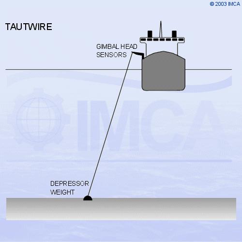
Sketch 4.3 - Taut Wire Principles
4.4 - The DGPS Position Reference System
DGPS has become the most commonly-used position reference for DP operations14, 15. The US Department of Defense (DoD) Global Positioning System (GPS) is in widespread general use, with typical accuracies available from the GPS Standard Positioning Service (SPS - civilian access) of 20m (68% RMS or 1 sigma). Prior to May 2000 the DoD applied a further downgrading known as ‘selective availability’ (SA), which reduced SPS accuracy to values around 100m. SA has been switched off, but the DoD reserves the right to re-apply it. Even without SA, GPS accuracy is not adequate for DP purposes.
In order to improve GPS accuracy to levels useful for DP, differential corrections are applied to GPS data. This is done by establishing reference stations at known points on the WGS 84 spheroid (the working spheroid of the GPS system). The pseudo ranges derived by the receiver are compared with those computed from the known locations of the satellites and reference station, and a Pseudo-Range Correction (PRC) derived for each satellite. These corrections are then included in a telemetry message sent to the ship’s receiver by a data link. The receiver then applies the PRCs to the observed pseudo ranges to compute a differentially corrected position.
Differential GPS systems are provided on-board by a service provider. The provider maintains and operates a network of reference stations worldwide and will install receiving equipment onboard to access the services.
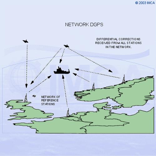
4.4.1 - Network DGPS
Most DGPS services accept multiple differential inputs obtained from an array of reference stations widely separated. Generally, network DGPS systems provide greater stability and accuracy, and remove more of the ionospheric error than obtainable from a single reference station. Network systems are more comprehensively monitored at the Hub, or control stations, where user information or warning data may be generated and sent out.
Sketch 4.4 - Network DGPS configuration
The choice of which link to hire or purchase must be made based on the vessel's expected work areas. If a vessel is expected to be working near fixed platforms, a local HF connection can be best. For floating production, storage and offloading (FPSO) vessels, a local UHF link and relative GPS solution can be the best arrangement.
The accuracy obtainable from DGPS systems is in the area of 1-3m dependent upon the distances to the reference stations, ionospheric conditions, and the constellation of satellites available. DGPS tends to be less reliable in close proximity to large structures (ie. platforms) due to interference to satellite and differential signals. DGPS performance near the magnetic equator has suffered due to scintillation (sun spot activity causing ionospheric disturbances). This reached a peak in 2001 with the maximum of the 11-year sunspot cycle.
4.4.2 - Relative GPS
Some DP operations require the positioning of a vessel relative to a moving structure. An example of this is the operation of a DP shuttle tanker loading via a bow loading hose from the stern of an FPSO. The FPSO may be turret-moored, so it can weathervane. The stern of the FPSO describes the arc of a circle, as well as surge sway and yaw motions, providing a complex positioning problem for the shuttle tanker.
Sketch 4.5 - Relative GPS
An Artemis20 and a DARPS system (Differential, Absolute and Relative Positioning System) are configured to handle this problem. For the measurement of relative position by GPS, differential corrections are not needed, as the errors induced are the same for the shuttle tanker as they are for the FPSO. A DARPS transmitter on the FPSO sends the received GPS data to the UHF receiver aboard the shuttle tanker. A computer aboard the shuttle tanker then calculates a range/bearing from the FPSO’s stern, which is put in to the DP control system as position reference in the same way as Artemis.
4.4.3 - The GLONASS system
GLONASS (the Global Navigation Satellite System11) is the Russian counterpart to the American GPS, being similar in design and operation. The system was initiated with the first satellite launches in 1982, and by 1996, 24 operational satellites were in orbit. However, this