

files / 421_гис-2 / arcview 3.2a / avdocs / newin32
.pdf1
Welcome to ArcView® GIS. Whether you’re an experienced user, or just getting started with ArcView GIS, this guide will introduce you to all of the new features and capabilities introduced in ArcView GIS since version 3.0.
Each new release exemplifies ESRI’s commitment to enhancing the user experience with ArcView GIS. ArcView GIS 3.1 introduced a wizardbased approach towards accomplishing a variety of more sophisticated tasks such as advanced map production and advanced geoprocessing. Task wizards, along with other updates focusing on enhancing usability, leverage more of the power of ArcView GIS to help you more quickly and easily accomplish your Geographic Information Systems (GIS) objectives.
ArcView GIS 3.1 also introduced several new extensions, specifically designed to supplement your GIS requirements. In particular, ArcView GIS features a report writer extension that enables you to easily generate professional reports, including embedded maps and charts, that help you more successfully communicate the results of your GIS analysis.
ArcView GIS 3.2 provides both strategic updates to existing capabilities as well as new tools to facilitate your GIS operations. Specifically, ArcView GIS 3.2 includes an updated report writer (based on Seagate® Software’s Crystal ReportsTM 7.0), updated support for CAD data, and significant database access improvements for leveraging data stored in either Spatial Database Engine (SDE) or Object Database Connectivity (ODBC) databases.
ArcView GIS 3.2 also introduces a new shapefile projection utility, providing support for an extensive range of data projections and datum transformations, as well as support for several new data formats.
ESRI Data & Maps has also expanded to five CD’s full of new and updated data.
This guide describes all of the new features and capabilities introduced for both ArcView GIS 3.1 and 3.2. Features introduced with ArcView GIS 3.2 can be easily identified on the Contents page by the 3.2 notation for each appropriate topic. For a complete description of the other features of ArcView GIS, please refer to the ArcView GIS user guide, “Using ArcView GIS”, and the online help system.
whatsnewin32.p65 |
1 |
8/5/99, 9:25 AM |

2 What’snewinArcViewGIS
whatsnewin32.p65 |
2 |
8/5/99, 9:25 AM |
What’snewinArcViewGIS 3
Application level
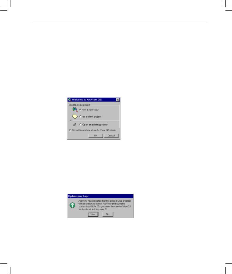
Startup Screen dialog
Created with new users in mind, this dialog gives quick and easy access to some of the most common tasks performed when first starting ArcView GIS. You can choose to create a new project (either blank or with a view) or to open an existing one. Clear the check box to stop the dialog from displaying when ArcView GIS opens.
If you do not want the dialog displayed again, delete the avstart.txt file in your TEMP directory (PC) or $HOME directory (UNIX).
Project update for existing projects
When opening a project that has a customized interface (that is, the project uses one of ESRI’s optional extensions, or contains changes to buttons, tools, or menus through the use of the Customize dialog box) and was created using ArcView GIS 3.0 or 3.0a, ArcView GIS will show the following message box:
To update your project, click Yes. The new Version 3.1 tools will be added to your interface. To leave your project as is, click No. Your project will not be updated.
whatsnewin32.p65 |
3 |
8/5/99, 9:25 AM |

4 What’snewinArcViewGIS
Expanded date support
The supported range of the value of the Date class in ArcView GIS is no longer limited to 1970 to 2038. ArcView GIS now supports a Date range from 4715 B.C. to 9999 A.D. While dates beyond this range may work, they may not produce consistent results for all Avenue requests. For more information, refer to the ‘Date (Class)’ topic in the ArcView GIS online help index.
ArcView GIS will recognize dates from January 1, 0000 to December 31, 9999, in dBASE® files and from January 1, 1000, to December 31, 9999, in INFO™ files. Dates outside this range are given a value of null when retrieved from a table. Delimited text files store dates as strings that can be converted to dates with Avenue™ . This means the delimited text file date range is the same as Avenue Date class range.
For more information regarding Year 2000 compliance, please visit our Web page at www.esri.com.
Improved support for ARC/INFO line symbols
Prior to 3.1, ArcView GIS could not display some types of ARC/INFO® line symbols— particularly custom symbols, such as multilayer or LineType Marker. Now most ARC/INFO line symbols can be used in ArcView GIS.
New TrueType fonts and symbols
New and enhanced symbol palettes include:
•Geology.avp: nearly 300 line and marker symbols for making U.S. Geological Survey (USGS) compliant geologic maps
•Weather.avp: additional weather frontline symbols
•Transp.avp: additional railroad line symbols
•Forestry.avp: line and marker symbols for creating forest fire-fighting maps
whatsnewin32.p65 |
4 |
8/5/99, 9:25 AM |

What’snewinArcViewGIS 5
Import multilayer ARC/INFO line symbols
You can now import multilayer ARC/INFO line symbols into ArcView GIS. Even if you do not have access to ARC/INFO, you can create your own symbols using new Avenue classes added to support these new capabilities. For more information, refer to the ‘symbols, how to create complex line symbols using Avenue’ topic in the ArcView GIS online help index.
Import ARC/INFO LineType Marker symbols
You can also import LineType Marker and LineType VertexMarker from ARC/INFO symbol sets. The ARC/INFO marker symbols you import must already be defined using TrueType® fonts. (This capability became available in ARC/INFO 7.1.) You will need to create a new version of the TrueType font and name it appropriately so that ArcView GIS can match the information in the LineSet file and use the correct font and character for your font.
If the ARC/INFO symbol was created using the older IGL font technology, ArcView GIS will still import the symbol, including all of its properties, except the marker symbol. The current default marker symbol in ArcView GIS will be used, but you can use Avenue to substitute one that’s more appropriate. For script examples, refer to the ‘symbols, Avenue examples’ topic in the ArcView GIS online help index.
New ways to customize the ArcView GIS application
Tools directory added to $AVHOME
A directory called ‘tools’ has been added to your $AVHOME directory. This directory contains the following:
•The extensions that load automatically when ArcView GIS starts (Startup Screen dialog, Create Buffers wizard, Label and Text tools, Neatline button, Shape Properties dialog, and TOC Style). If you don’t want an extension to load automatically, you can move it to the $AVHOME\ext32 directory—the extension will then be visible in the Extensions dialog. This provides a new way for developers to deliver functionality in ArcView GIS and load it automatically.
•A ‘bitmaps’ directory containing bitmaps used in the new interfaces that are based on Dialog Designer dialogs.
Extension .apr files available
The $AVHOME\samples\ext directory contains the project files used to create the extensions listed above. You can customize the extensions by editing the project files and creating new versions of the extensions.
whatsnewin32.p65 |
5 |
8/5/99, 9:25 AM |
6What’snewinArcViewGIS
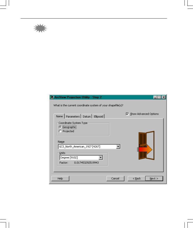
3.2ArcView GIS projection utility
ArcView GIS 3.2 includes a new utility that enables users to project shapefiles into a common coordinate system. The projection utility supports an extensive array of projections as well as datum conversions (including NAD27 to NAD83). The projection utility includes a wizard driven interface that guides you through the process of 3.2 selecting the input theme or data source to be projected, accepting default or setting custom projection parameters, and specifying the output theme or data source name. The utility then creates a new shapefile and a metadata file that contain information about the current projection parameters for the new shapefile.
The Shapefile Projection Utility can be launched from the ArcView GIS user interface as an extension, or run as a stand-alone utility.
The ArcView GIS projection utility is not available on UNIX® .
whatsnewin32.p65 |
6 |
8/5/99, 9:25 AM |
What’snewinArcViewGIS 7
Views and themes
View properties
Background color
A new button on the View Properties dialog allows you to change the view’s background color. From the View menu, choose Properties, and then click Select Color  . The new background color will also be maintained when displayed in a layout.
Setting projection for already-projected data
When you are adding projected data as a theme, ArcView GIS will detect whether it might be projected and prompt you to set your view’s projection. You are not prompted if the extent of themes is beyond the standard geographic coordinates.
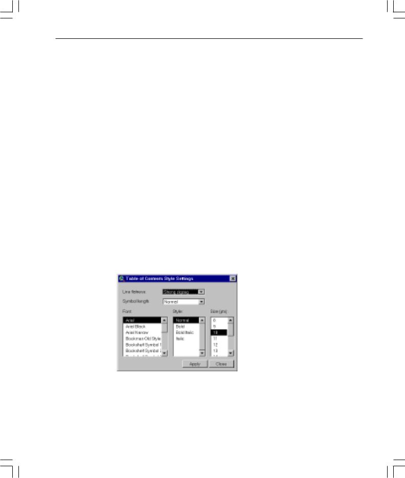
TOC Style
A new menu choice, TOC Style, has been added to the View’s View menu. TOC Style lets you change the following display settings of the Table of Contents (TOC): line flatness (degree to which the line symbols in the legend are flat), symbol length (the length of the line symbol in the TOC), and TOC text symbol (how text in a legend appears).
whatsnewin32.p65 |
7 |
8/5/99, 9:25 AM |
8 What’snewinArcViewGIS
Label and text tools
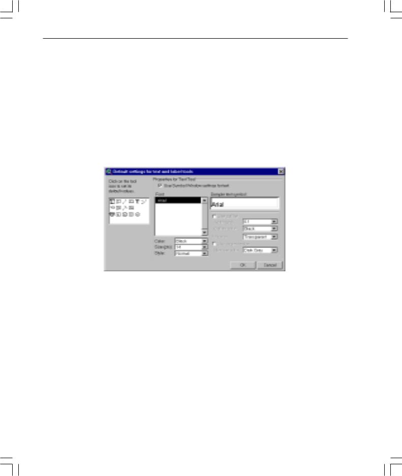
Default settings for text and label tools dialog
ArcView GIS 3.1 upgrades the Label tool and the Text tool as tool menus with additional options for placing labels and text in a view or layout. These menus are now expanded to support the following new capabilities: labeling with a leader line pointing to a feature, labeling using banners, labeling using callouts, labeling with a background and drop shadow, and labeling highways with standard highway shield symbols.
Default settings can be changed using the new Default settings for text and label tools dialog, accessible from the Graphics menu. When you click on one of the icons, options associated with the tool appear in the menu.
A sample extension for autolabeling more than one theme is also available in this release.
Spline text tool
A new Spline text tool  with the ability to align text or position it along curved lines has been added in this release. The tool is presented as an option on the Text tool menu. After indicating where you want text drawn (by clicking in your view or layout), use the Spline Text Properties dialog to enter, align, and draw your text.
whatsnewin32.p65 |
8 |
8/5/99, 9:26 AM |

What’snewinArcViewGIS 9
Convert shapefiles to projected units
For projected views, Convert to Shapefile will now ask you if you want the new shapefile to be created in projected units. Previously, Convert to Shapefile only output the new shapefile in decimal degrees for projected views. (For nonprojected views, the new shapefile was and still will be created in the units of the base data.)
Adding themes
Adding already-projected data to a projected view
Add Theme will now warn you if you try to add already-projected data to a projected view (unless you are adding images). The data will be added to the view anyway, but it may not display properly, as you can’t view already-projected data in a projected view.
ESC cancels directory scan for Add Theme
ESC cancels directory scan for Add Theme. This allows you to immediately stop ArcView GIS from reading all the directories. For example, if you have a folder with forty folders in it, and you want to go to the third in the list, wait for ArcView GIS to display the first three folders, then press ESC. Now double-click on the third folder in the list.
Map and distance units automatically set
When adding a theme, if ArcView GIS detects that your data is in decimal degrees, it will automatically set the map and distance units for you.
New View menu options
Manage Data Sources under View menu
A new menu choice, Manage Data Sources, has been added to the View’s File menu. Manage Data Sources lets you copy, rename, and delete shapefiles.
Save Project As and Extensions under File menu
Save Project As and Extensions have been added to the View’s File menu to make these options more accessible. (They have also been added to the interfaces of the other document types as well, such as the Layout’s File menu, the Project’s File menu, and the Table’s File menu.)
whatsnewin32.p65 |
9 |
8/5/99, 9:26 AM |

10 What’snewinArcViewGIS
Create Buffers wizard
Accessed from the View’s Theme menu, this wizard provides an easy-to-use set of panels for creating buffers. Using the panels, you will be able to select what and how to buffer, set buffer options, and specify where output should be saved.
Views can be exported into JPEG format
Views can now be exported into JPEG format.
ESC stops drawing of themes
Pressing ESC will immediately stop the drawing of themes without clearing the view’s display. (To support this functionality, the ESC accelerator to turn off all themes has been removed.)
whatsnewin32.p65 |
10 |
8/5/99, 9:26 AM |