

files / 421_гис-2 / arcview 3.2a / avdocs / newin32
.pdfWhat’snewinArcViewGIS 31
Optional extensions
The optional extensions bring advanced, specialized GIS analysis to the desktop. They are available as separate software.
ArcView 3D Analyst extension
ArcView 3D Analyst extension provides a suite of high-quality, easy-to-use tools for creating, analyzing, and displaying surface data. This extension’s unique capabilities include support for the TIN data model, 3D shapes, and interactive perspective viewing.
whatsnewin32.p65 |
31 |
8/5/99, 9:26 AM |
32 What’snewinArcViewGIS
ArcPress for ArcView extension
ArcPress™ is a graphics metafile rasterizer that enhances the printing and exporting capabilities of ArcView GIS. ArcPress takes an ArcView GIS layout, rasterizes the data, and lets you set a variety of output, page, and print options.
ArcView Business Analyst extension
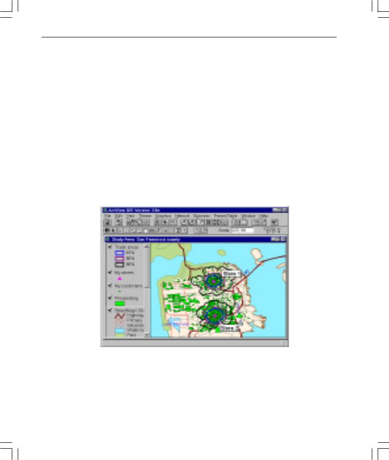
ArcView Business Analyst extension is a unique set of GIS tools and data designed specifically for business applications. ArcView Business Analyst lets users easily create and analyze market areas, perform site prospecting, profile customers and prospect for similar ones, conduct drive-time analysis, and create detailed reports. This extension captures the power of sophisticated data analysis through an easy-to-use wizard interface that guides you through your crucial business tasks. Included with the software is a comprehensive nationwide suite of business, household, demographic, and street data as well as the ArcView Network Analyst extension and the ArcView StreetMap™ extension.
The ArcView Business Analyst extension is not available on UNIX.
whatsnewin32.p65 |
32 |
8/5/99, 9:26 AM |
What’snewinArcViewGIS 33
ArcView Image Analysis extension
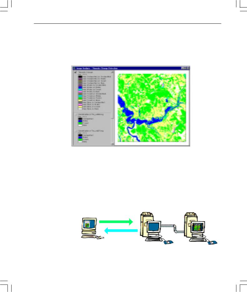
Developed in close collaboration with leading image-processing software vendor, ERDAS, Inc., the ArcView Image Analysis extension provides easy-to-use analysis tools that allow you to display, enhance, and analyze remotely sensed imagery.
ArcView Internet Map Server extension
ArcView Internet Map Server (IMS) extension is a map publishing tool that makes putting your maps on the Web an easy process. The extension automatically creates a ready-to-use Web page containing your map and an interactive user interface you can use to browse, explore, and query it. You can also customize the Web pages IMS creates for you by adding your own text, graphics, backgrounds, and links, either by editing the HTML source directly, or by using a third party Web page authoring program. ArcView IMS uses a Java™ applet, called MapCafe™ , to provide the user interface for your map when it appears on a Web page.
Requests
TCP/IP network
Maps
Web user
somewhere Your web server ArcView GIS in the world
whatsnewin32.p65 |
33 |
8/5/99, 9:26 AM |

34 What’snewinArcViewGIS
ArcView Network Analyst extension
ArcView Network Analyst extension enables you to use geographic networks (such as streets, highways, rivers, pipelines, or electric lines) to solve problems such as finding the best travel route, generating travel directions, finding the closest emergency vehicle or facility, or defining service areas based on travel time. Network data used with this extension can come from any of the following sources: ArcView line shapefiles, ARC/INFO network or regular line coverages, and CAD drawings.
whatsnewin32.p65 |
34 |
8/5/99, 9:26 AM |
What’snewinArcViewGIS 35
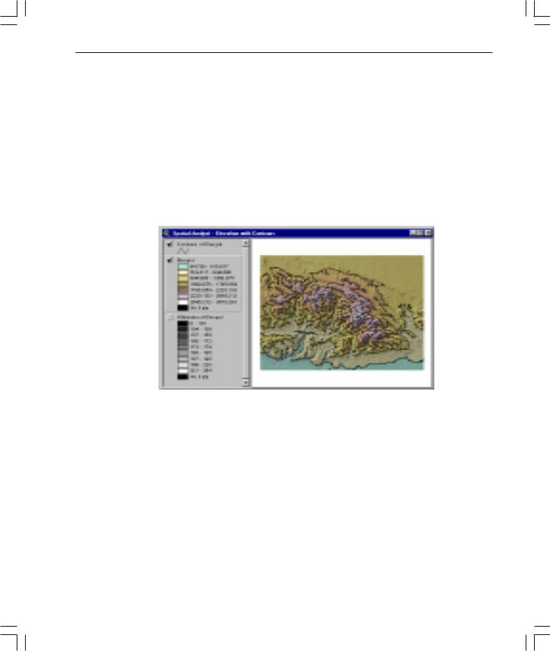
ArcView Spatial Analyst extension
ArcView Spatial Analyst extension provides tools to create, view, query, and analyze map cell-based raster data and to perform integrated vector-raster analysis using feature-based and grid-based themes.
Capabilities include conversion of feature themes to grid themes, creation of buffer distance and proximity surfaces from feature or grid themes, contouring and density mapping from themes containing point features, slope and aspect mapping, cell-based map analysis, Boolean query on multiple grid themes, neighborhood and zone analysis, and grid classification and display. The extension includes an extensive Avenue programming interface for developing spatial analysis applications.
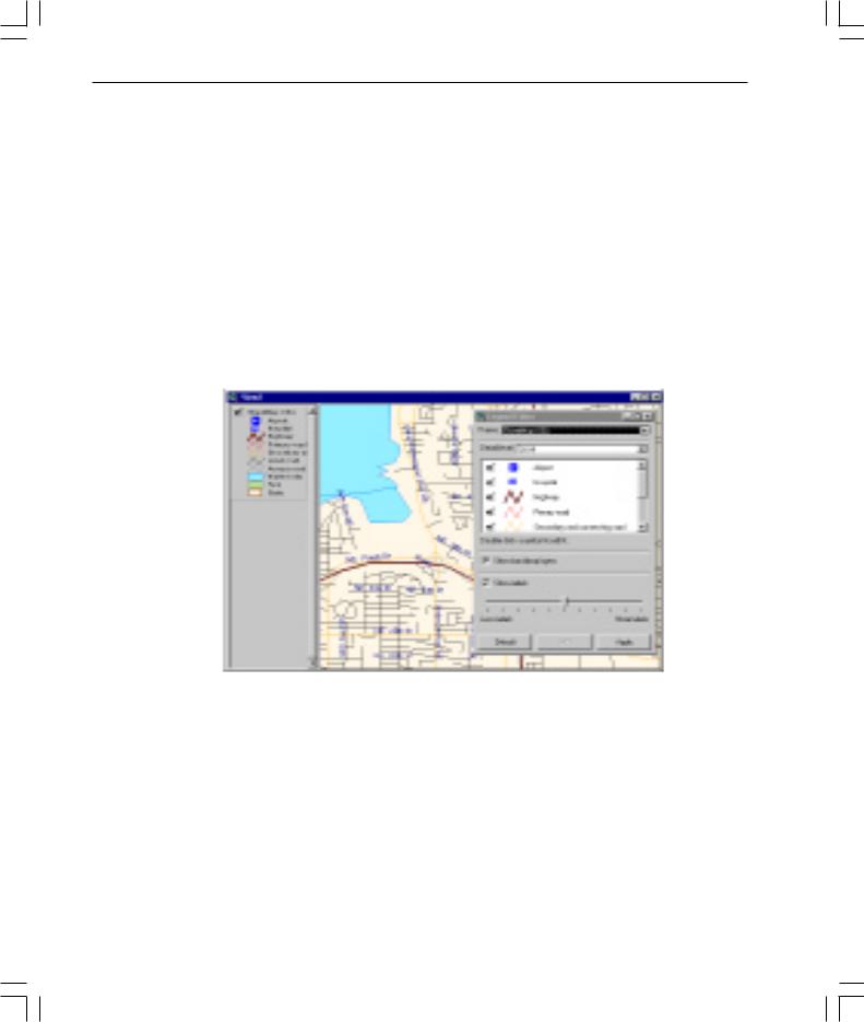
ArcView StreetMap extension
ArcView StreetMap extension adds nationwide address geocoding and street map display to ArcView GIS and includes a compressed street and landmark database for the entire United States on a single CD. The StreetMap extension uses data sourced from Wessex Streets 6.0. Wessex, a division of Geographic Data Technology, Inc. (GDT), enhances TIGER 97 by removing the telltale TIGER “wiggle” that results in streets that are not straight. StreeMap data is in NAD83 coordinates.
The ArcView StreetMap extension is not available on UNIX.
whatsnewin32.p65 |
35 |
8/5/99, 9:26 AM |
36 What’snewinArcViewGIS
ArcView StreetMap 2000 extension
ArcView StreetMap 2000 extension is enhanced StreetMap software developed jointly by ESRI and GDT. StreetMap 2000 supports nationwide address geocoding and street map display. This extension uses GDT’s Dynamap/2000 ® database, released in January of 1999, and GDT’s Matchmaker® geocoding engine. GDT’s Matchmaker geocoder offers traditional geocoding capabilities and allows the matching of intersections and addresses composed of alphanumeric notations. An Interactive Matcher dialog box displays addresses that failed to match, explains the problem, and suggests possible alternatives. Additionally, state boundaries, cities, airports, hospitals, parks, lakes, and river data are integrated in to the display of the data found on the CD. The new StreetMap 2000 will be in NAD83 coordinates.
The ArcView StreetMap 2000 extension is not available on UNIX.
whatsnewin32.p65 |
36 |
8/5/99, 9:26 AM |

What’snewinArcViewGIS 37
ArcView Tracking Analyst extension
ArcView Tracking Analyst extension can be used by anyone needing to view and analyze the movement and status of objects through time. Developed in close collaboration with TASC Inc., a major provider of advanced information technology solutions for governments and businesses worldwide, Tracking Analyst supports realtime Global Positioning System (GPS) and network connections, allowing you to map events in real time. For example, you could follow your delivery vehicles on their daily routes, track weather conditions such as hurricanes or lightning, or study the migration routes of animals.
The ArcView Tracking Analyst extension requires ArcView GIS 3.1 or higher and is available on Windows 98® , Windows NT® 4.0, and Solaris™ .
whatsnewin32.p65 |
37 |
8/5/99, 9:26 AM |

38 What’snewinArcViewGIS
whatsnewin32.p65 |
38 |
8/5/99, 9:26 AM |

What’snewinArcViewGIS 39
ESRI Data & Maps
3.2ArcView GIS 3.2 expands on the Canada, Mexico, United States and World data included in the last release and replaces the European data sets with cartographically
improved information for the whole of Europe. The biggest change is the conversion to NAD83 coordinates for all of the United States data. Legend files (.avl) are provided along with projection files (.prj) which will be automatically used by the ArcView Projection Utility.
United States
Several improvements have been made to the United States data with this release. ZIP Code point and polygon data have been updated to 1999. GDT Dynamap/2000 v9.0 has been used to update major roads, major water, and all landmark layers including: large area landmarks, parks, transportation terminals, retail centers, recreation areas, institutions and airports. Area code boundaries from GDT and municipal boundaries are included, as well as incorporation of designated marketing area (DMA) boundaries. 1999 population estimates from CACI are incorporated into the attributes of state, county, census tract, and zip polygons.
World
Additional data for the world includes the World Wildlife Fund Conservation Science Program World Ecological Regions, and a true color image of the world created from AVHRR data enhanced with shaded relief at 4km resolution created by WorldSat International, Inc.
Europe
Data for Europe includes layers for roads, water and rivers, rail, cities, country, and administrative unit boundaries.
Images
A set of sample images for the area around Orlando, Florida, USA, courtesy of the MapFactory illustrate the different kinds of imagery that are available from image data sources. The sample includes examples of Landsat Thematic Mapper, SPOT Panchromatic imagery, Indian Resource Satellite, and 1 foot resolution ortho photos.
whatsnewin32.p65 |
39 |
8/5/99, 9:26 AM |

40 What’snewinArcViewGIS
whatsnewin32.p65 |
40 |
8/5/99, 9:26 AM |