

BENIN |
39 |
|
General |
39 |
Buoyage System |
39 |
Currency |
39 |
Government |
39 |
Holidays |
40 |
Industries |
40 |
Languages |
40 |
Navigational Information |
40 |
Search and Rescue |
40 |
Time Zone |
40 |
U.S. Embassy |
40 |
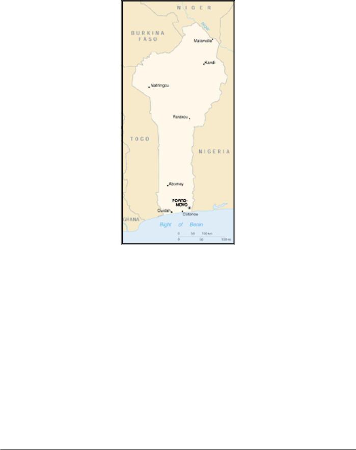
General
Benin, formerly Dahomey, is bounded on the E by Nigeria, on the N by Niger and Burkina Faso, on the W by Togo, and on the S by the Gulf of Guinea. Its coast, 65 miles long, is flat and sandy with scattered lagoons and mangrove swamps.
The country extending inland is flat and covered with tropical vegetation. The ground rises gradually, about 50 miles inland, to a plateau that attains elevations of 304 to 487m.
The far N region of the country consists of a featureless plateau that attains an elevation of about 760m and slopes down toward the Niger River, on the N border.
The climate is equatorial in the coastal region, with a long rainy season from March to July and a short rainy season from October through November. The dry season increases away from the coast, with some inland areas having rain only between May and September.
The country has average temperatures of 27.8˚C in January and 25˚C in July.
Buoyage System
The IALA Buoyage System (Region A) is in effect. See Chart No. 1 for further IALA Buoyage System information.
Currency
The official unit of currency is the franc CFA (French African Community franc), consisting of 100 centimes.
Government
Benin is a republic. The country is divided into 12 departments.
Pub. 160
40 |
Benin |
Flag of Benin
Benin is governed by a directly-elected President serving a 5-year term.The unicameral National Assembly consists of 83 directly-elected members serving 4-year terms.
The legal system is based on French civil law and customary law.
The capital is Porto-Novo. Cotonou is the seat of government.
Holidays
The following holidays are observed:
January 1 |
New Year’s Day |
January 10 |
Traditional Religions Day |
Easter Sunday |
Variable |
Easter Monday |
Variable |
May 1 |
Labor Day |
Ascension Day |
Variable |
Whitmonday |
Variable |
August 1 |
Independence Day |
October 26 |
Armed Forces Day |
November 1 |
All Saints’ Day |
November 30 |
National Day |
December 25 |
Christmas Day |
Islamic holidays, which are subject to the appearance of the moon, include Eid Al-Fitr (End of Ramadan), Eid Al-Adha (End of Pilgrimage), and the Prophet’s Birthday.
Industries
The major industries are palm-oil processing, cement, sugar, livestock raising, forestry, chemicals, paper, and textiles. An offshore oil field is being developed.
Crops include cassava, yams, maize, sorghum, millet, beans, rice, groundnuts, cotton, sugarcane, coffee, and tobacco.
Languages
French is the official language. The tribal languages of Fon and Yoruba are used in the S region; at least six other tribal dialects are used in the N.
Navigational Information
The maritime territorial claims of Benin are, as follows:
Territorial Sea |
200 miles. |
Fisheries or Economic |
200 miles. |
Zone |
|
Search and Rescue
The Port of Cotonou is responsible for coordinating search and rescue operations. A Maritime Rescue Coordination Center (MRCC) is located at Cotonou.
Time Zone
The Time Zone description is ALFA (-1). Daylight Savings Time is not observed.
U.S. Embassy
The U.S. Embassy is situated at Rue Caporal Bernard Anani, Cotonou.
The mailing address is 01 BP 2012, Cotonou.
U. S. Embassy Benin Home Page
http://cotonou.usembassy.gov
Pub. 160
BRAZIL |
41 |
|
General |
41 |
Buoyage System |
41 |
Cautions |
41 |
Currency |
42 |
Firing Areas |
42 |
Government |
44 |
Holidays |
45 |
Industries |
45 |
Languages |
45 |
Navigational Information |
45 |
Pilotage |
45 |
Regulations |
45 |
Search and Rescue |
45 |
Signals |
46 |
Submarine Operating Areas |
46 |
Time Zone |
46 |
U.S. Embassy |
47 |
Vessel Traffic Service |
47 |
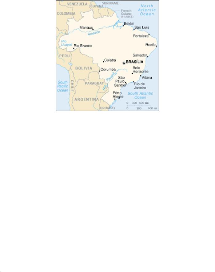
General
Brazil is located in the NE part of South America and borders the Atlantic Ocean. It is bounded on the N by French Guiana, Suriname, Guyana, and Venezuela; on the W by Colombia, Peru, Bolivia, Paraguay, and Argentina; and on the S by Uruguay.
The greater part of the country consists of hilly uplands, plateaus, and low mountains. There is a narrow coastal belt but very little of the land can be considered a plain, except for the area in the upper Amazon Basin.
The Amazon River and its tributaries, which traverse the heavily-wooded N lowlands, form the greatest river system in the world and provide over 13,700 miles of channels that are
safe for navigation. The headwaters of the Amazon drain the Andes from Colombia to Bolivia. The river is 3,500 miles long and rises in Lago Lauricocha, Peru, about 100 miles NNE of Lima.
The coast is about 4,000 miles long and is mostly fronted by low, flat beaches. Numerous small rivers reach the shore but are seldom navigable for more than a few miles.
The climate is mostly tropical, but factors such as elevation, distance from the sea, and prevailing winds cause some variation and temperatures are not extreme.
Buoyage System
The IALA Buoyage System (Region B) is in effect. See Chart No. 1 for further IALA Buoyage System information.
Cautions
Offshore Oil Exploration
Offshore oil exploration is taking place on the continental shelf off the N and E coasts of Brazil. The main areas of exploration are, as follows:
1.The N approaches to the Amazon River.
2.Between Ponta de Itapage (2˚51'S., 39˚57'W.) and Cabo Calcanhar (5˚10'S., 35˚29'W.).
3.Between Maceio (9˚40'S., 35˚40'W.) and Aracaju (11˚00'S., 37˚02'W.).
4.Off Salvador (13˚00'S., 38˚30'W.).
5.Off Caravelas (17˚45'S., 39˚10'W.).
6.Off Vitoria (20˚10'S., 40˚15'W.).
7.Southeast of Cabo de Sao Tome (22˚00'S., 40˚59'W.). Within these areas, numerous oil drilling rigs, platforms, and
associated structures may be encountered. In addition, vessels
Pub. 160

42 |
Brazil |
should use caution as drilling rigs may also be carrying out operations on the continental shelf outside of the above areas.
Mobile drilling rigs and temporary lighted buoys are not charted; however, their positions may be promulgated from time to time by Brazilian Notice to Mariners.
Light Vessels
Light vessels in Brazil display a secondary light from their sterns, which should be taken into account when passing a light vessel.
Currency
The official unit of currency is the real, consisting of 100 centavos.
Firing Areas
Firing exercises are promulgated by local Radio Navigational Warnings. The following exercise areas are used by the Brazilian Navy:
1.Area B-1 (SSE of Ponta Negra)—Naval exercises— Enclosed by a line joining the following:
a.23˚10'00"S, 42˚12'30"W.
b.23˚10'00"S, 42˚45'06"W.
c.23˚35'00"S, 42˚45'06"W.
d.23˚35'00"S, 42˚12'30"W.
2.Area B-2 (S of Cabo Frio)—Naval exercises.— Enclosed by a line joining the following:
a.23˚10'00"S, 41˚40'12"W.
b.23˚10'00"S, 42˚12'30"W.
c.23˚35'00"S, 42˚12'30"W.
d.23˚35'00"S, 41˚40'12"W.
3.Area B-3 (S of Cabo Frio)—Naval exercises.— Enclosed by a line joining the following:
a.23˚35'00"S, 41˚40'12"W.
b.23˚35'00"S, 42˚12'30"W.
c.24˚00'00"S, 42˚12'30"W.
d.24˚00'00"S, 41˚40'12"W.
4.Area B-4 (SSE of Ponta Negra)—Naval exercises.— Enclosed by a line joining the following:
a.23˚35'00"S, 42˚12'30"W.
b.23˚35'00"S, 42˚45'12"W.
c.24˚00'00"S, 42˚45'12"W.
d.24˚00'00"S, 42˚12'30"W.
5.Area C-1 (Saquarema approaches)—Gunnery exer- cises.—Enclosed by a line joining the following:
a.22˚56'12"S, 42˚45'06"W.
b.22˚56'12"S, 42˚12'30"W.
c.23˚10'00"S, 42˚12'30"W.
d.23˚10'00"S, 42˚45'06"W.
Anchorage and fishing are prohibited.
6. Area C-2 (Cabo Frio)—Gunnery exercises.—En- closed by a line joining the following:
a.22˚45'00"S, 41˚58'00"W.
b.22˚45'00"S, 41˚40'12"W.
c.23˚10'00"S, 41˚40'12"W.
d.23˚10'00"S, 42˚12'30"W.
e.22˚56'12"S, 42˚12'30"W. Anchorage and fishing are prohibited.
7.Area C-3 (E of Cabo Frio)—Gunnery exercises.— Enclosed by a line joining the following:
a.22˚45'00"S, 41˚08'06"W.
c.22˚45'00"S, 41˚40'12"W.
b.23˚10'00"S, 41˚40'12"W.
d.23˚10'00"S, 41˚08'06"W. Anchorage and fishing are prohibited.
8.Area C-4 (E of Cabo Frio)—Gunnery exercises.— Enclosed by a line joining the following:
a.23˚10'00"S, 41˚40'12"W.
b.23˚10'00"S, 41˚08'06"W.
c.23˚35'00"S, 41˚08'06"W.
d.23˚35'00"S, 41˚40'12"W.
Anchorage and fishing are prohibited.
9. Area C-5 (ESE of Cabo Frio)—Gunnery exercises.— Enclosed by a line joining the following:
a.23˚35'00"S, 41˚40'12"W.
b.23˚35'00"S, 41˚08'06"W.
c.24˚00'00"S, 41˚08'06"W.
d.24˚00'00"S, 41˚40'12"W. Anchorage and fishing are prohibited.
10.Area Delta (Ilha de Alcatrazes).—Enclosed by a line joining the following:
a.24˚06'00"S, 45˚27'00"W.
b.24˚01'00"S, 45˚35'00"W.
c.24˚02'00"S, 45˚46'30"W.
d.24˚14'00"S, 45˚51'00"W.
e.24˚15'00"S, 45˚36'00"W.
The above area is reserved for surface gunnery exercises by the Brazilian Navy and is considered dangerous for navigating, fishing, and anchoring.
11.Area D-1 (Barra do Porto do Rio de Janeiro)—Naval exercises.—Enclosed by a line joining the following:
a.22˚56'12''S, 43˚16'42''W.
b.22˚56'12''S, 42˚45'06''W.
c.23˚12'00''S, 42˚45'06''W.
d.23˚13'30''S, 42˚46'30''W.
e.23˚06'06''S, 42˚54'00''W.
f.23˚13'30''S, 43˚01'30''W.
g.23˚06'06''S, 43˚09'12''W.
h.23˚13'30''S, 43˚16'42''W.
12.Area D-2 (Ilha Maricas)—Naval exercises.—En- closed by a line joining the following:
a.23˚12'00''S, 42˚45'06''W.
b.23˚28'12''S, 42˚45'06''W.
c.23˚20'00''S, 42˚54'00''W.
13.Area D-3 (SE of Ilha Rasa)—Naval exercises.—En- closed by a line joining the following:
a.23˚27'12''S, 42˚46'30''W.
b.23˚28'12''S, 42˚45'06''W.
Pub. 160

Brazil |
43 |
c.23˚42'18''S, 42˚45'06''W.
d.23˚34'18''S, 42˚54'00''W.
14.Area D-4 (SSE of Ilha Rasa)—Naval exercises.—En- closed by a line joining the following:
a.23˚27'12''S, 43˚01'30''W.
b.23˚42'18''S, 42˚45'06"W.
c.23˚50'00''S, 42˚45'06"W.
d.23˚50'00''S, 43˚16'42''W.
e.23˚41'06"S, 43˚16'42''W.
15.Area D-5 (SSE of Ilha Rasa)—Naval exercises.—En- closed by a line joining the following:
a.23˚13'30''S, 43˚16'42''W.
b.23˚20'00''S, 43˚09'12''W.
c.23˚27'12''S, 43˚16'42''W.
d.23˚20'00''S, 43˚24'12''W.
16.Area E-1 (Baia da Ilha Grande)—Naval exercises.— Enclosed by a line joining the following:
a.23˚00'00''S, 44˚00'00''W.
b.23˚00'00''S, 44˚41'00''W.
c.23˚25'00''S, 44˚41'00''W.
d.23˚25'00''S, 44˚00'00''W.
17.Area E-2 (Ilha Grande)—Naval exercises.—Enclosed by a line joining the following:
a.23˚00'00''S, 44˚00'00''W.
b.23˚00'00''S, 43˚16'42''W.
c.23˚13'30''S, 43˚16'42''W.
d.23˚25'00''S, 43˚29'24''W.
e.23˚25'00''S, 44˚00'00''W.
18.Area E-3 (Ilha Grande)—Naval exercises.—Enclosed by a line joining the following:
a.23˚25'00''S, 44˚00'00''W.
b.23˚25'00''S, 43˚29'24''W.
c.23˚20'00''S, 43˚24'12''W.
d.23˚34'18''S, 43˚09'12''W.
e.23˚41'06''S, 43˚16'42''W.
f.23˚50'00''S, 43˚16'42''W.
g.23˚50'00''S, 44˚00'00''W.
19.Area E-4 (Restinga da Marambaia)—Gunnery exer- cises.—Enclosed by a line joining the following:
a.23˚50'00''S, 43˚16'42''W.
b.23˚50'00''S, 44˚00'00''W.
c.24˚15'00''S, 44˚00'00''W.
d.24˚15'00''S, 43˚16'42''W.
Anchorage and fishing are prohibited.
20.Area E-5 (S of Restinga da Marambaia)—Gunnery exercises.—Enclosed by a line joining the following:
a.23˚25'00''S, 44˚30'00''W.
b.23˚25'00''S, 44˚00'00''W.
c.24˚15'00''S, 44˚00'00''W.
d.24˚15'00''S, 44˚30'00''W.
21.Area F-1 (SW of Ilha de Sao Sebastiao)—Gunnery exercises.—Enclosed by a line joining the following:
a.23˚25'00''S, 45˚08'42''W.
b.23˚25'00''S, 45˚04'18''W.
c.24˚15'00''S, 45˚04'18''W.
d.24˚15'00''S, 45˚34'30''W.
e.23˚45'18''S, 45˚34'30''W.
22.Area F-2 (Approaches to Ilha de Sao Sebastiao)— Gunnery exercises.—Enclosed by a line joining the following:
a.23˚25'00''S, 45˚04'18''W.
b.23˚25'00''S, 44˚30'00''W.
c.24˚15'00''S, 44˚30'00''W.
d.24˚15'00''S, 45˚04'18''W.
23.Area R-1 (S of Ilha Rasa)—Gunnery exercises.— Enclosed by a line joining the following:
a.23˚50'00''S, 43˚16'42''W.
b.23˚50'00''S, 42˚45'06''W.
c.24˚15'00''S, 42˚45'06''W.
d.24˚15'00''S, 43˚16'42''W.
24.Area R-2 (S of Ilha Rasa)—Gunnery exercises.— Enclosed by a line joining the following:
a.24˚15'00''S, 43˚16'42''W.
b.24˚15'00''S, 42˚45'06''W.
c.24˚45'00''S, 42˚45'06''W.
d.24˚45'00''S, 43˚16'42''W.
25.Area S-1 (W of Ilha Rasa)—Gunnery exercises.— Enclosed by a line joining the following:
a.24˚15'00''S, 44˚00'00''W.
b.24˚15'00''S, 43˚16'42''W.
c.24˚45'00''S, 43˚16'42''W.
d.24˚45'00''S, 44˚00'00''W.
26.Area S-2 (Approaches to Ilha de Sao Sebastiao)— Gunnery exercises.—Enclosed by a line joining the following:
a.24˚15'00''S, 45˚04'18''W.
b.24˚15'00''S, 44˚00'00''W.
c.24˚45'00''S, 44˚00'00''W.
d.24˚45'00''S, 45˚04'18''W.
The following restricted areas are aerial spaces for firing practices and rocket launching, whose limits cover maritime areas:
1.Aquiraz Area.— A circular area with a radius of 2.7 miles centered at 3˚55'00"S, 38˚20'00"W, used for gunnery exercises. The area comes into operation once the NOTAM (Notice to Airmen) is promulgated.
2.Jangada Area.— A permanent area enclosed by a line joining positions a, b, c, d, and e, having positions c and d joined by an arc of 10 miles radius centered in position f.
a.3˚03'00"S, 38˚22'00"W.
b.3˚14'00"S, 37˚54'00"W.
c.3˚36'00"S, 38˚21'00"W.
d.3˚38'00"S, 38˚37'00"W.
e.3˚37'00"S, 38˚40'00"W.
f.3˚43'00"S, 38˚28'00"W.
Pub. 160

44 |
Brazil |
3.Barreira Area.— A permanent area for missile launching enclosed by a line joining the following:
a.5˚54'00"S, 35˚11'00"W.
b.5˚56'00"S, 35˚11'00"W.
c.5˚47'00"S, 34˚56'18"W.
d.6˚03'54"S, 34˚57'12"W.
4.Satelite Area.— An area for rocket launchings enclosed by a line joining the following:
a.4˚59'18"S, 34˚31'36"W.
b.5˚28'18"S, 34˚09'42"W.
c.5˚38'48"S, 35˚02'30"W.
d.5˚54'00"S, 35˚11'00"W.
e.5˚56'00"S, 35˚11'00"W.
f.6˚23'36"S, 34˚19'54"W.
The area comes into operation once the NOTAM is promulgated.
5. Pirangi Area.— An area for firing exercises enclosed by a line joining positions a, b, c, and d, having as an inner limit an arc of 24 miles radius and as an outer limit an arc of 32 miles radius, both centered on position e.
a.6˚03'54"S, 34˚52'42"W.
b.5˚49'30"S, 34˚51'18"W.
c.5˚47'48"S, 34˚43'30"W.
d.6˚07'00"S, 34˚45'18"W.
e.5˚54'30"S, 35˚14'54"W.
The area comes into operation once the NOTAM is promulgated.
6. Touros Area.— An area for firing exercises enclosed by a line joining the following:
a.5˚15'00"S, 34˚45'00"W.
b.5˚07'00"S, 34˚38'00"W.
c.4˚51'00"S, 34˚57'00"W.
d.5˚00'00"S, 35˚03'00"W.
The area comes into operation once the NOTAM is promulgated.
7. Marte Area.— An area for gunnery exercises enclosed by a line joining the following:
a.5˚26'00"S, 35˚05'00"W.
b.5˚18'00"S, 34˚58'00"W.
c.5˚01'00"S, 35˚06'00"W.
d.5˚01'00"S, 35˚18'00"W.
The area comes into operation once the NOTAM is promulgated.
8.Restinga Area.— A circular area for firing exercises, permanent in nature, with a radius of 5.5 miles centered at position a, limited by a straight line joining positions b and c.
a.23˚04'00"S, 43˚52'00"W.
b.23˚04'00"S, 43˚47'20"W.
c.23˚10'00"S, 43˚52'00"W.
9.Marambaia Area.— An area for firing exercises enclosed by a line joining the following:
a.23˚02'00"S, 43˚51'00"W.
b.23˚05'00"S, 43˚51'00"W.
c.23˚02'00"S, 43˚35'00"W.
d.23˚04'00"S, 43˚35'00"W.
This is a permanent area under visual meteorological conditions and may come into operation once the NOTAM is promulgated.
10. Atlantico Area.— An exercise area enclosed by a line joining the following:
a.23˚02'00"S, 43˚36'00"W.
b.23˚03'00"S, 43˚35'00"W.
c.23˚37'00"S, 44˚07'00"W.
d.23˚20'00"S, 44˚22'00"W.
The area comes into operation once the NOTAM is promulgated.
11. Moreia Area.— An area for firing exercises enclosed by a line joining the following:
a.23˚45'00"S, 42˚30'00"W.
b.23˚45'00"S, 43˚10'00"W.
c.24˚20'00"S, 43˚10'00"W.
d.24˚20'00"S, 42˚30'00"W.
The area comes into operation once the NOTAM is promulgated.
12.Campos Novos Area.— A circular area with a radius of 1.1 miles centered at 22˚42'30"S, 42˚00'00"W, used for firing exercises. The area comes into operation once the NOTAM is promulgated.
13.Oceano Area.— A permanent area for military aircraft and firing practices enclosed by a line joining the following:
a.23˚27'00"S, 43˚52'00"W.
b.23˚30'00"S, 43˚50'00"W.
c.24˚08'00"S, 44˚35'00"W.
d.23˚45'00"S, 44˚44'00"W.
14.Pinhal Area.— An area bound by true bearings of 108˚ and 123˚ of Salgado Filho radiobeacon (Porto Alegre), forming a sector whose internal limit is an arc with a radius of 60 miles and whose outer limit is an arc with a radius of 85 miles, both centered at position 29˚59'25"S, 51˚09'48"W.
Government
Flag of Brazil
Brazil is a federal republic. The country is divided into 26 states and one federal district.
Brazil is governed by a directly-elected President serving a 4-year term. The bicameral National Congress consists of an
Pub. 160

Brazil |
45 |
81-member Senate (two-thirds are directly elected, with the remaining one-third indirectly elected) serving 8-year terms and a 513-member Chamber of Deputies (directly elected according to proportional representation) serving 4-year terms.
The legal system is based on Roman codes. The capital is Brasilia.
Holidays
The following holidays are observed:
January 1 |
New Year’s Day |
Carnival (the |
Variable |
two days before |
|
Ash Wednesday) |
|
Ash Wednesday |
Variable |
(half day until |
|
1300) |
|
Good Friday |
Variable |
Easter Sunday |
Variable |
April 21 |
Martyrdom of Tiradentes |
May 1 |
Labor Day |
Corpus Christi |
Variable |
September 7 |
Independence Day |
October 12 |
Nossa Senhora Aparecida |
November 1 |
All Saints’ Day |
November 2 |
All Souls’ Day |
November 15 |
Proclamation of the Republic |
December 24 |
Christmas Eve (half day) |
December 25 |
Christmas Day |
December 31 |
New Year’s Eve (half day) |
In addition, numerous local holidays (religious and traditional) are observed at the various ports.
Industries
The main industries are agriculture, livestock raising, and forestry.
Other industries include oil and natural gas production, textiles, motor vehicles, rubber, resins, chemicals, fishing, wood products, and food processing.
Minerals mined include quartz crystal, industrial diamonds, chrome ore, mica, zirconium, beryllium, graphite, titanium,, thorium, manganese, tungsten, lead, asbestos, bauxite, barites, apatite, tin, silver, gold, and coal.
Crops include coffee, cotton, cocoa, sugarcane, maize, wheat, oranges, bananas, tobacco, rice, castor beans, jute, potatoes, cannabis, cassava, sisal, and soya.
Languages
Portuguese is the official language. Spanish, English, and French are also used.
Navigational Information
The maritime territorial claims of Brazil are, as follows:
Territorial Sea * |
12 miles. |
Contiguous Zone |
24 miles. |
Fisheries or Economic |
200 miles. |
Zone ** |
|
*Requires advance permission or notification for innocent passage of warships in the territorial sea. Claims to require permission for more than three warships of the same flag to be in the territorial sea at the same time.
**Military exercises in the EEZ can only be conducted with prior permission.
Pilotage
Pilotage is compulsory for foreign vessels of any gross tonnage and for all Brazilian vessels over 2,000 grt carrying oil, gas, or dangerous cargo.
Regulations
Vessels must fly the Brazilian flag at the foremast in Brazilian waters from 0800 to sunset daily. The customs flag, blue with a white star, must be flown 24 hours after clearance is granted.
In order for forts, patrol craft, and lookout posts to establish the identity of ships in the approaches to ports, vessels entering or leaving must display their ensign when within 3 miles of the entrance to a port or anchorage and, by day, also display their name (call sign) in flags of the International Code of Signals.
Vessels navigating within 200 miles of the Brazilian coast should maintain a continuous listening watch on VHF channel 16.
Anchoring and fishing are prohibited within 500m of all submarine cables.
Search and Rescue
A series of Maritime Rescue Coordination Centers (MRCC) is located, as follows:
1. MRCC Brazil (Rio de Janeiro)—Can be contacted by e-mail, as follows:
mrccbrazil@con.mar.mil.br
2.MRCC South (Rio Grande)
3.MRCC Southeast (Rio de Janeiro)
4.MRCC East (Salvador)
5.MRCC Northeast (Natal)
6.MRCC North (Belem)
Pub. 160

46 |
Brazil |
A network of coast radio stations maintains a continuous listening watch on international distress frequencies.
Signals
At some Brazilian ports, weather conditions may prevent the pilot from boarding a vessel. In these circumstances, vessels can be guided into port by signals given from the pilot vessel or a watch boat, as follows:
1.Pilot boat.—Signals are given by hand using a red signal flag. The flag is lowered towards the side of the pilot boat which the vessel should steer; if the signal flag is in the center, the vessel’s rudder should be amidships. The speed with which the signal flag is displaced indicates the speed with which the rudder should be applied to keep the vessel in the channel.
2.Watch boat.—Signals are given from a mast, by a black sphere, which runs under the yardarm. The position of the sphere in relation to the mast indicates the side the vessel should steer towards; if the sphere is in the center, the vessel’s rudder should be amidships. The speed with which the sphere is displaced indicates the speed with which the rudder should be applied to keep the vessel in the channel.
Submarine Operating Areas
Submarines of the Brazilian Navy when engaged in submerged exercises, may, or may not be accompanied by escorting warships. If accompanied, an escorting vessel will display the signal “NE2” from the International Code of Signals, meaning that one or more submarines are exercising in the vicinity.
All other vessels, military and commercial, not taking part in the exercises shall clear the area.
When vessels sight one or two orange buoys on the surface showing flashing or fixed white lights of low intensity, they should investigate, as these buoys could belong to a submarine in distress or in need of help. Sometimes the buoys are unlighted.
Brazilian Tupi class submarines have a marking/transmitting buoy moored to them. The buoy is orange, 86cm in diameter, and 2.47m high, with gray vertical bands, and a white light that flashes 33 times per minute. The buoy has reflectors and a plate with a number and the instructions “Avisar A Autorodade Naval Competente Afundado/Finder Inform Navy Coast Guard Or Police Do Not Secure To Or Touch” inscribed in Portuguese and English. The buoy transmitter operates on 8364kHz and 243MHz for up to 72 hours.
The signal, transmitted in morse, is silence for 120 seconds; the serial number of submarine repeated three times in 30 seconds; SOS repeated six times in 27 seconds; SUBSUNK repeated three times in 36 seconds; and a goniometric signal for 30 seconds. The entire cycle is then repeated.
In addition to the marking/transmitting buoys, a submarine in distress may signal with air or oil bubbles. If vessels sight any of these buoys or receives any of the radio signals mentioned above, they should report this information immediately to the nearest Brazilian Naval vessel or to the first authority with which it can establish contact. Under no circumstances should vessels or boats moor to any of these buoys.
Submarines operating within Brazilian territorial waters and navigating on the surface, may exhibit, in addition to the conventional lights prescribed by the International Rules, an all-round intermittent yellow (amber) light with 90 flashes per minute. If necessary, they may exhibit only the intermittent light.
The following exercise areas, promulgated by local Radio Navigational Warnings, are used by submarines of the Brazilian Navy:
1.Area A-1 (SSE of Ilha Rasa)—Enclosed by a line joining the following:
a.23˚13'30"S, 43˚01'30"W.
b.23˚20'00"S, 42˚54'00"W.
c.23˚27'12"S, 43˚01'30"W.
d.23˚20'00"S, 43˚09'12"W.
2.Area A-2 (S of Ilha Rasa)—Enclosed by a line joining the following:
a.23˚06'06"S, 43˚09'12"W.
b.23˚13'30"S, 43˚01'30"W.
c.23˚20'00"S, 43˚09'12"W.
d.23˚13'30"S, 43˚16'42"W.
3.Area A-3 (SE of Ilha Rasa)—Enclosed by a line joining the following:
a.23˚06'06"S, 42˚54'00"W.
b.23˚13'30"S, 42˚46'30"W.
c.23˚20'00"S, 42˚54'00"W.
d.23˚13'30"S, 43˚01'30"W.
4.Area A-4 (S of Ilha Rasa)—Enclosed by a line joining the following:
a.23˚20'00"S, 43˚09'12"W.
b.23˚27'12"S, 43˚01'30"W.
c.23˚34'18"S, 43˚09'12"W.
d.23˚27'12"S, 43˚16'42"W.
5.Area A-5 (SSE of Ilha Rasa)—Enclosed by a line joining the following:
a.23˚20'00"S, 42˚54'00"W.
b.23˚27'12"S, 42˚46'30"W.
c.23˚34'18"S, 42˚54'00"W.
d.23˚27'12"S, 43˚01'30"W.
Time Zone
Brazil is covered by multiple Time Zones, as follows:
1.Eastern states (except No. 2 below)—The Time Zone description is PAPA (+3). Daylight Savings Time (OSCAR (+2)) is maintained from the beginning of November through the middle of February of the following year; the exact changeover dates should be obtained from local authorities.
2.Northeastern states and East Para—The Time Zone description is PAPA (+3). Daylight Savings Time is not observed.
3.Western states (except No. 4 below)—The Time Zone description is QUEBEC (+4). Daylight Savings Time (PAPA (+3)) is maintained from the beginning of November through
Pub. 160
Brazil |
47 |
the middle of February of the following year; the exact changeover dates should be obtained from local authorities.
4.Rondonia, West Para, Amazonas, and Roraima—The Time Zone description is QUEBEC (+4). Daylight Savings Time is not observed.
5.Acre and Tabatinga City—The Time Zone description is ROMEO (+5). Daylight Savings Time is not observed.
6.Archipelago de Fernando de Noronha and Ilha de Trindade—The Time Zone description is OSCAR (+2). Daylight Savings Time is not observed.
U.S. Embassy
The U.S. Embassy is situated at Avenida das Nacoes, Quadra 801, Lote 3, CEP: 70403-900, Brasilia, Distrito Federal.
The mailing address is Unit 3500, APO AA 34030.
U. S. Embassy Brazil Home Page
http://www.embaixada-americana.org.br
Vessel Traffic Service
Maritime Traffic Information System (SISTRAM)
Brazil has signed the International Convention for the Safety of Life at Sea and the International Convention on Maritime Search and Rescue (SAR). Therefore, Brazil is required to utilize all available means to help any merchant ship in distress within its own SAR maritime area of responsibility.
To achieve this goal, Brazil uses the Maritime Traffic Information System (SISTRAM), an electronic information system for maritime traffic operated by the Naval Command for the Control of Maritime Traffic (COMCONTRAM). This system tracks all merchant vessels engaged in ocean, coastal, and inland navigation within the Brazilian SAR area.
SISTRAM is compatible with the AMVER system and provides quick identification of nearby vessels which may be capable of assisting ships in distress. In addition, the system can help to render urgent medical assistance.
The greater the number of vessels participating in the program, the greater the effectiveness, the reliability, and the security of the ships themselves. Therefore, all merchant ships are invited to participate in the system. Ships participating in the system add to the safety of life at sea as they can arrive at the scene of a SAR incident before any other means is sent from the shore.
Participation by Brazilian ships is mandatory; however, participation by foreign vessels is voluntary. The participation involves the transmission of standard type messages which are free when sent to COMCONTRAM through the Brazilian Coastal Radio Stations Network (RENEC).
Even though participating in SISTRAM by foreign vessels is voluntary, foreign vessels that are still within the Brazilian territorial sea of 12 miles are still required, under penalty of fines, to report the following information:
1.Position.
2.Course.
3.Speed.
4.Port of departure.
5.Port of destination.
6.ETA.
This information can be submitted through SISTRAM, participation in which is free of charge, provided the report is sent through RENEC.
Participation in SISTRAM begins when a vessel sends a Type 1 message (Sailing Plan) and ends when the vessel sends a Type 4 message (Final Report).
Any nonparticipating vessel may join SISTRAM at any time by sending a Type 1 message. Such a vessel may leave SISTRAM at any time by sending a Type 4 message. Line X should be completed in the Final Report, including the reason for terminating participation.
SISTRAM Area
The SISTRAM area is bounded by a line joining the following positions:
a.4˚30.5'N, 51˚38.2'W.
b.8˚35.0'N, 48˚00.0'W.
c.10˚00.0'N, 48˚00.0'W.
d.10˚00.0'N, 36˚00.0'W.
e.7˚40.0'N, 35˚00.0'W.
f.6˚22.0'S, 16˚00.0'W.
g.6˚22.0'S, 10˚00.0'W.
h.34˚00.0'S, 10˚00.0'W.
i.34˚00.0'S, 48˚27.0'W.
j.35˚48.0'S, 50˚10.0'W.
k.34˚00.0'S, 53˚00.0'W.
Types of Messages
Type 1 (Sailing Plan).— This report provides the basic information required to estimate the ship's position. It can be sent when the ship joins SISTRAM, when departing from a Brazilian port, or when entering the Brazilian SISTRAM area from other ports.
Preferably, the Sailing Plan will be sent as early as possible prior to entering the SAR area or prior to departure from a Brazilian port. In port, it may be sent as a written document.
Type 2 (Position Report).— This report confirms if the ship departed, or if its position is correct per the Sailing Plan. It must be sent within the first 24 hours after departing from a Brazilian port.
Position Reports can be sent whenever the ship is in heavy weather or under other adverse conditions and at any time interval desired.
Type 3 (Deviation Report).— This report provides information for necessary corrections to the existing Sailing Plan. A deviation report should be sent whenever the ship's position deviates 25 miles or more from the original track, the destination port is changed, or other changes occur which result in changing the Sailing Plan.
Type 4 (Final Report).— The Final Report provides the information which terminates participation in SISTRAM. Accordingly, reports should be sent at least 1 hour before entering the destination port or when exiting the SISTRAM area.
Transmission of Messages
Reports addressed to COMCONTRAM are free of charge and can be sent through the following Brazilian Coast Radio Stations:
1.Juncao (PPJ).
2.Rio (PPR).
Pub. 160

48 |
Brazil |
3.Olinda (PPO).
4.Belem (PPL).
5.Manaus (PPM).
Alternatively, reports addressed to COMCONTRAM RIO can be sent by radiotelex, number 2136931 (reports sent in this way are chargeable).
For further details, vessels may contact COMCONTRAM, as follows:
1. Surface mail address:
Edificio Almirante Tamandare - 6 andar Praca Barao de Ladario, S/N Centro
Rio de Janeiro - RJ - Brazil CEP: 20091-000
2.Telephone: 55-21-3870-6353
3.Facsimile: 55-21-3870-6341
4.Telex: 38 (021) 2136931/2130933
5.E-mail address: controle@cotram.mar.mil.br
6.Web site: http://www.comcontram.mar.mil.br
Reporting Format
Each message consists of a selection of items from the message format list. Message items should be separated by a stroke (/), omitted items by a dash between two strokes (/-/), and the end of the message by a double stroke (//). The system name (SISTRAM), type of message, and date-time group should precede every message. The message format is as follows:
System Name (SISTRAM) / Type of Message (1, 2, 3, or 4)/Date-Time-Month-Year of Transmission//
A/Call sign/Vessel name/Flag/Type//
B/Date-time of departure//
C/Latitude/Longitude//
E/Current course//
F/Estimated average speed//
G/Port of departure/Latitude/Longitude//
I/Port of destination/Latitude/Longitude//
K/Port of arrival or exit point/Latitude/Longitude/ETA//
L/Average speed/Latitude/Longitude/ETA//
M/Current coastal radio station/Next coastal radio station//
V/Onboard medical resources//
X/Amplifying comments (up to 65 characters)//
Y/Comments//
The following notes apply to the format:
1.Date-Time.— All date-time groups start with six (6) digits. The first two (2) digits are the day of the month. The next four (4) digits are hours and minutes using the 24-hour clock. Only Universal Coordinate Time (UTC) (GMT) is to be used. The date-time group (six-digit) must be followed by the capital letter Z. The remainder of the Date-Time group must contain the first three letters of the month and the last two digits of the year.
2.Type of Vessel.— Select as appropriate:
•CGO-General cargo
•TKR-Tanker
•BLK-Bulk carrier
•PAS-Passenger
•FSH-Fish
•TUG-Tug
•CTR-Container carrier
•ROL-Roll on/roll off
3.Latitude/Longitude.— Latitude is a four-digit group expressed in degrees and minutes and suffixed with “N” for North or “S” for South. Longitude is a five-digit group expressed in degrees and minutes and suffixed with “E” for East or “W” for West.
4.Route Information.— The information about the proposed route, in line L, is expressed by three (3) points. When a ship enters the SAR area, show in the first line “L” of the Type 1 message (Sailing Plan) the latitude/longitude of that point and the estimated time of arrival (ETA). In the Type 3 message (Deviation Report), in the first line “L,” insert the data about the points where the course changes or of the first point which confirms deviation (if greater than 25 miles) from the planned route.
5.Onboard Medical Resources.— Select as appropriate:
•MD-Physician
•PA-Physician's assistant or Health Supervisor
•NURSE-Nurse
•NONE-None
6.Optional Data Items.— These optional data items are useful but are not required. Line E contains the current course as a three-digit group. Line F contains the estimated average speed for the entire passage expressed in knots and tenths of a knot.
7.Lines X and Y (Reference data items).— Optional information such as reference data for SISTRAM is entered on line X. Examples include date-time estimates for the next transmission, type of cargo, or INMARSAT number. Line Y can be used for any other type of communication at the discretion of the merchant vessel.
8.Course Deviation Data Items.— This is used to specify changes to the Type 1 message (Sailing Plan). An example is shown below:
I/Salvador/1258S/03831W/051800Z//
In this case, the destination port was changed to Salvador.
Messages
Type 1 (Sailing Plan) consists of items (in order of transmission) A/B/G/I/L/V/M/X/Y.
Type 2 (Position Report) consists of items (in order of transmission) A/B/C/E/F/M/X/Y.
Type 3 (Deviation Report) consists of items (in order of transmission) A/I/L/M/X/Y.
Type 4 (Final Report) consists of items (in order of transmission) A/K/X/Y.
Pub. 160