

TOGO |
229 |
|
General |
229 |
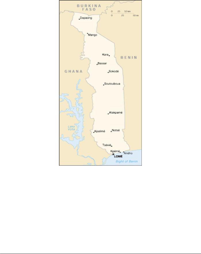
The seacoast, 28 miles long, lies between a position about |
Buoyage System |
230 |
0.8 mile SW of Lome (6˚07'N., 1˚13'E.) and a point 2 miles E |
Currency |
230 |
of Anecho. |
Government |
230 |
Togo is traversed from SW to NE by a mountain range, |
Holidays |
230 |
which divides the country into two nearly equal triangles. The |
Industries |
230 |
NW region consists of lowlands drained by rivers and bounded |
Languages |
230 |
on the N by hills. The SE region is made up of low-lying |
Navigational Information |
230 |
coastal districts, with lagoons in the S part and an interior |
Time Zone |
230 |
plateau in the N. There are long stretches of forest and bush- |
U.S. Embassy |
230 |
wood. The dry plains alternate with arable land. |
General
Togo is located on the W coast of Africa. It is bounded on the W by Ghana, on the N by Burkina Faso, and on the E by Benin.
The tropical climate produces wet seasons from March to July and from October to November in the S part.
The N part has one wet season, from April to July. The heaviest rainfall occurs in the mountains of the W, SW, and central parts.
Pub. 160
230 |
Togo |
Buoyage System
The IALA Buoyage System (Region A) is in effect. See Chart No. 1 for further IALA Buoyage System information.
Currency
The official unit of currency is the French African Community franc, consisting of 100 centimes.
Government
Flag of Togo
Togo is a republic. The country is divided into five regions. The country is governed by a directly-elected President
serving a 5-year term. The Prime Minister is appointed by the President. The unicameral National Assembly consists of 81 directly-elected members serving 5-year terms.
The legal system is based on French civil law and customary law.
The capital is Lome.
Holidays
The following holidays are observed:
January 1 |
New Year’s Day |
January 13 |
Liberation Day |
January 24 |
Sarakawa (Economic Liberation |
|
Day) |
Good Friday |
Variable |
Easter Sunday |
Variable |
Easter Monday |
Variable |
April 27 |
Independence Day |
May 1 |
Labor Day |
May 8 |
Victory Day |
Ascension Day |
Variable |
Whitsunday |
Variable |
Whitmonday |
Variable |
August 15 |
Assumption Day |
November 1 |
All Saints’ Day |
December 25 |
Christmas Day |
Ramadan and Tabaski are Islamic holidays, the dates of which vary depending on the appearance of the moon.
Industries
The main items of commerce are based on coffee, cocoa, palm oil, palm kernels, copra, groundnuts, cotton, and manioc. The major food crops include maize, yams, cassava, and groundnuts.
There are extensive deposits of bauxite and phosphate. Other mineral deposits include limestone, iron ore, and marble. A cement works, an oil refinery, and a steel mill are situated at Lome. Small, but developing, industries include textiles and food processing.
Languages
French is the official language The major African languages spoken are Ewe and Mina, in the S part of the country, and Dagomba and Kabye, in the N part of the country.
Navigational Information
The maritime territorial claims of Togo are, as follows:
Territorial Sea |
30 miles. |
Fisheries or Economic |
200 miles. |
Zone |
|
Time Zone
The Time Zone description is ZULU. Daylight Savings Time is not observed.
U.S. Embassy
The U.S. Embassy is situated at Angle Rue Kouenou and Rue 15 Beniglato, Lome.
The mailing address is B.P. 852, Lome, Togo.
U.S. Embassy Togo Home Page http://lome.usembassy.gov
Pub. 160
UNITED ARAB EMIRATES |
231 |
|
General |
231 |
Buoyage System |
231 |
Cautions |
231 |
Currency |
231 |
Firing Areas |
231 |
Government |
231 |
Holidays |
232 |
Industries |
232 |
Languages |
232 |
Mined Areas |
232 |
Navigational Information |
232 |
Regulations |
232 |
Search and Rescue |
232 |
Time Zone |
232 |
U.S. Embassy |
232 |
Cautions
Special Warning 121 (Issued 20 March 2003)
Information on Special Warning 121 can be found in Iraq— Cautions.
Special Warning 115 (Issued 5 March 2001)
Information on Special Warning 115 can be found in Iraq— Cautions.
Currency
The official unit of currency is the Emirian dirham, consisting of 100 fils.
General
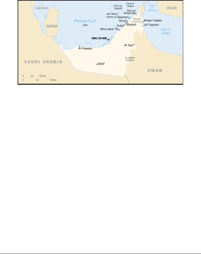
The United Arab Emirates is located on the E side of the Arabian Peninsula. It is bounded on the N by the Persian Gulf, on the E by Oman and the Gulf of Oman, and on the S and W by Saudi Arabia.
The United Arab Emirates has a dispute with Iran concerning the territorial claims of several islands in the Persian Gulf.
The country consists of a flat, barren coastal plain that merges into a vast desert with rolling dunes. Some mountains rise in the E part.
The climate is mostly hot, dry desert being somewhat cooler in the mountains.
Buoyage System
The IALA Buoyage System (Region A) is in effect. See Chart No. 1 for further IALA Buoyage System information.
Firing Areas
Naval firing practices (surface-to-surface and surface-to-air) and other exercises take place within Area No. 1 (NE of Abu Dhabi) enclosed by the following positions:
a.24˚47'N, 54˚35'E.
b.25˚02'N, 54˚30'E.
c.25˚02'N, 54˚07'E.
Details of firing exercises within the above area will be broadcast as warnings by Bahrain Radio (A9M) on 500 kHz, normally 3 days in advance. Vessels are advised to avoid the area, or if it is necessary to enter, to proceed with caution.
Government
The United Arab Emirates is a federation of seven emirates, each with its own ruler.
The United Arab Emirates is governed by a President elected by the Federal Supreme Council (composed of the rulers of the seven emirates) serving a 5-year term. The unicameral Federal National Council (FNC) consists of 40 members appointed by the rulers of the emirate to serve 2-year terms. The FNC may
Pub. 160
232 |
United Arab Emirates |
Flag of United Arab Emirates
propose amendments to legislation and the federal budget drafted by the Council of Ministers, but has no executive power.
The legal system consists of a federal court introduced in 1971. All emirates except Dubayy and Ras al Khaymah have joined this federal system. All emirates have secular and Islamic law for civil and high courts.
The capital is Abu Dhabi.
Holidays
The following holidays are observed:
January 1 |
New Year’s Day |
December 2-3 U.A.E. National Day
Islamic holidays, which are subject to the appearance of the moon, include Eid Al-Fitr (End of Ramadan), Eid Al-Adha (End of Pilgrimage), Hijrah (Islamic New Year), Ashoora, Ascension of the Prophet, and the Prophet’s Birthday.
In some regions, the holiday of Ruler’s Accession Day (August 6) is observed.
naval vessels on VHF channel 13 or 16. Details of areas reported to be dangerous due to mines are also promulgated by Notice to Mariners issued by the Middle East Navigation Aids Service (MENAS) and by MARAD advisories.
Navigational Information
The maritime territorial claims of the United Arab Emirates are, as follows:
Territorial Sea * |
12 miles. |
Contiguous Zone |
24 miles. |
Fisheries or Economic |
200 miles. |
Zone ** |
|
Continental Shelf |
200 miles or the |
|
Continental Margin. |
*Requires advance permission or notification for innocent passage of warships in the territorial sea.
**The Exlcusive Econimic Zone extends to agreed Continental Shelf boundaries or to median lines.
Regulations
Masters are warned that public consumption of alcoholic drinks is strictly prohibited in the United Arab Emirates and its territorial waters. Crew members must not be allowed to offer alcohol to any Moslem for any reason whatsoever.
It has been reported (2003) that vessels calling at ports in Sharjah and Sharjah waters should appoint a local agent to advise the port of the vessel’s ETA, particulars, and purpose of call.
Industries
The main industries include crude oil and natural gas production. Other industries include construction materials, petrochemicals, fishing, and boat building.
Agriculture includes dates, vegetables, fruits, poultry, and livestock.
Languages
Arabic is the official language. Farsi and English are widely used in the major cities. Hindi and Urdu are also used.
Mined Areas
Vessels are advised that mined areas exist in the N part of the Persian Gulf. Further information should be obtained from the local authorities. Mine sightings should be reported to the naval authorities by INMARSAT (150-5612) or to Coalition
Search and Rescue
Emirates Coast Radio Station maintains a continuous listening watch on VHF channel 16 for distress traffic.
Time Zone
The Time Zone description is DELTA (-4). Daylight Savings Time is not observed.
U.S. Embassy
The U.S. Embassy is situated in the Safarat District (Embassy District), Road 4, Abu Dhabi.
The mailing address is P.O. Box 4009, Abu Dhabi.
U. S. Embassy United Arab Emirates
Home Page
http://usembassy.state.gov/uae
Pub. 160