

INDONESIA |
113 |
|
General |
113 |
Buoyage System |
113 |
Cautions |
113 |
Currency |
114 |
Government |
114 |
Holidays |
114 |
Industries |
114 |
Languages |
114 |
Mined Areas |
114 |
Navigational Information |
115 |
Regulations |
115 |
Search and Rescue |
115 |
Time Zone |
116 |
U.S. Embassy |
116 |
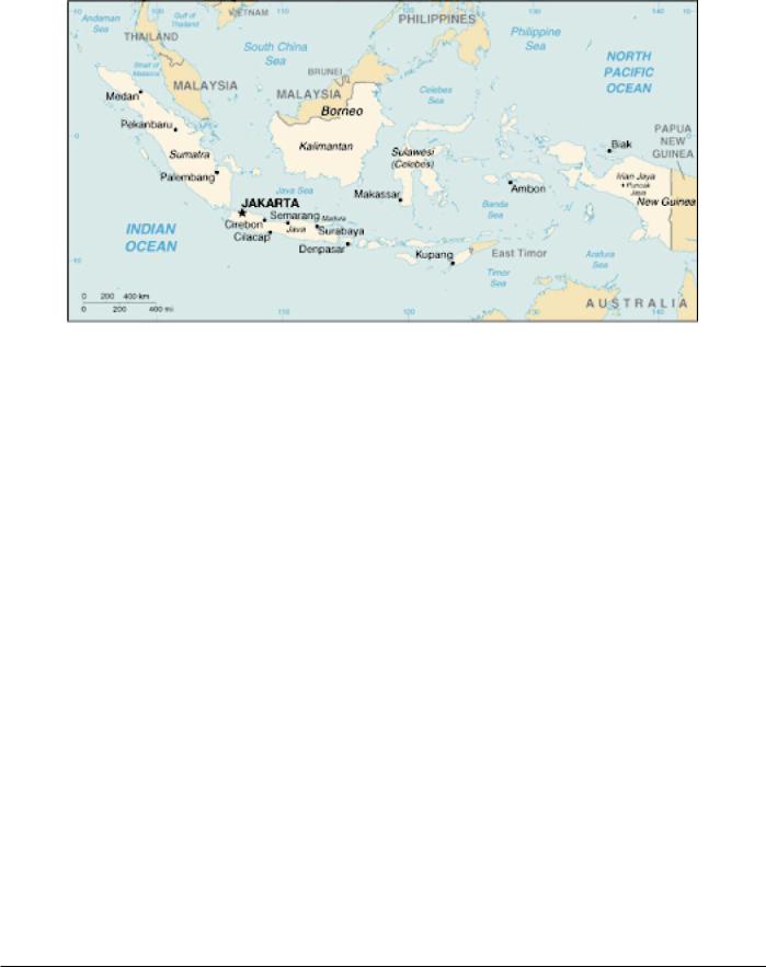
General
Indonesia consists of an archipelago of 17,508 islands that extends up to about 3,100 miles along the Equator between the mainland of Southeast Asia and Australia. The archipelago forms a natural barrier between the Indian Ocean and the Pacific Ocean. The main islands are Sumatera (Sumatra), Java, Sulawesi (formerly Celebes), Borneo (the S part of Kalimantan), and Irian Jaya (W half of New Guinea). Indonesia shares land borders with Malaysia and Papua New Guinea.
The terrain consists of mostly coastal lowlands but the larger islands have interior mountains and some volcanoes.
The climate is mostly tropical being hot and humid, while somewhat moderate in the mountain areas.
The former Portuguese colony of East Timor, which was abandoned in 1975, was occupied by Indonesia and claimed as the province of Timor Timir. The United Nations does not recognize Indonesian sovereignty over this territory. In 1999, the population of East Timor voted for independence. Shortly thereafter, the Indonesian parliament concurred with the vote. After a short period of United Nations administration, East
Timor became the Democratic Republic of Timor-Leste on May 20, 2002.
Buoyage System
The IALA Buoyage System (Region A) is in effect. See Chart No. 1 for further IALA Buoyage System information.
Cautions
Rigs
Movable oil drilling rigs and production platforms may be encountered off the coasts of Indonesia and in open waters. Buoys associated with the drilling operations are frequently moored in the vicinity of these structures. The positions of these rigs and buoys are frequently changed and are generally promulgated by radio navigational warnings.
Piracy
It was reported (1995) that vessels have been attacked by armed thieves in the vicinity of the Malacca and Singapore Straits, mainly near Phillip Channel. These attacks were usually made from fast motor boats approaching from astern. Loaded vessels with low freeboards seem to be particularly vulnerable.
The International Maritime Bureau (IMB) of the International Chamber of Commerce has established a Piracy Countermeasures Center at Kuala Lumpur. This center oper-ates for the Southeast Asian Region and is able to receive re-ports from vessels concerning attacks and advise of danger areas. Piracy warnings originated by the center will be broad-cast daily to NAVAREA XI, VIII, and X through Enhanced Group Calling using the SafetyNET System.
For further details, the IMB Center can be contacted, as follows:
IMB Piracy Reporting Center
ICC International Maritime Bureau
Pub. 160

114 |
Indonesia |
P.O. Box 12559 50782 Kuala Lumpur Malaysia
Telephone: +60-3-2031-0014 Facsimile: +60-3-2078-5769 Telex: MA31880 IMBPCI E-mail: imbkl@icc-ccs.org.uk
IMB Piracy Reporting Center Home Page
http://www.iccwbo.org/ccs/menu_imb_piracy.asp
Buoyage
Within Indonesian waters, lights and buoys are considered unreliable, being frequently irregular, extinguished, missing, or off station.
General
For further information concerning dangers in the vicinity of Sumatera (Sumatra) and the Malacca Strait, see Singapore— Cautions.
For further information concerning dangers in Indonesian waters, see Pub. 120, Sailing Directions (Planning Guide) Pacific Ocean and Southeast Asia.
Holidays
The following holidays are observed:
January 1 |
New Year’s Day |
Good Friday |
Variable |
Easter Sunday |
Variable |
Nyepi Saka |
Variable |
Ascension Day |
Variable |
Waisak |
Variable |
August 17 |
Independence Day |
December 25 |
Christmas Day |
December 31 |
New Year's Eve |
Islamic holidays, which are subject to the appearance of the moon, include the Ascension of the Prophet Muhammad (Isra Mi'raj), Eid Al-Fitter (End of Ramadan), Eid Al-Adha (End of Pilgrimage), Hijrah (Islamic New Year), and the Prophet’s Birthday.
Currency
The official unit of currency is the rupiah, consisting of 100 sen. It was reported (1997) that sen are no longer used.
Government
Industries
The principal industries include petroleum and natural gas production, textiles, shipyards, chemical factories, automobiles, cement, fertilizers, livestock raising, timber, mining, fishing, and tourism.
The main agricultural crops include rice, maize, sweet potatoes, copra, sugarcane, rubber, palm oil, tea, coffee, fruits, nuts, tobacco, and cloves.
Flag of Indonesia
Indonesia is a republic. The country is divided into 27 provinces, two special regions, and one special capital city district Indonesia is governed by a President,who is chosen by the People's Consultative Assembly to serve a 5-year term. The People's Consultative Assembly, which consists of the members of the House of People's Representatives plus 195 government appointees, meets every 5 years to choose the
President.
The unicameral House of People's Representatives consists of 500 members; 462 members are directly elected, while the remaining members are appointed from the armed forces. All members serve 5-year terms.
The legal system is based on Roman/Dutch law and is substantially modified by indigenous concepts.
The capital is Jakarta.
Languages
Bahasa Indonesia (a modified form of Malay) is the official language. English, Dutch, and several local dialects, the most common of which is Javanese, are also used.
Mined Areas
Danger Areas
Indonesia has declared the following areas dangerous due to mines which were laid during WWII:
1.The area of water bounded on the N side by the S coast of Palau Lingga, on the E side by 104˚48'E, on the S side by 0˚29'S, and on the W side by the NE coast of Palau Singkep and 104˚32'E.
2.A swept channel S of Palau Lingga, clear for all types of vessels, is bounded, as follows:
a.On the N side by a line joining 0˚20'06''S, 104˚32'00''E and 0˚23'06''S, 104˚48'00''E.
b.On the S side by a line joining 0˚21'30''S, 104˚32'00''E; 0˚22'00''S, 104˚35'00''E; 0˚23'18''S, 104˚39'48''E; and 0˚24'54''S, 104˚48'00''E.
3.A recommended track near Selat Berhala lying between 0˚54'00''S, 104˚18'00''E and 0˚54'00''S, 104˚35'00''E. Due to the lapse of time, proceeding through these mine-
fields, whether they have been swept or not, is now considered no more dangerous from mines than from any other of the
Pub. 160

Indonesia |
115 |
usual hazards to navigation. However, in the unswept areas a real danger still exists with regard to anchoring, fishing or carrying out any form of submarine or seabed activities.
For further information concerning mine danger, firing practice, and restricted areas in the vicinity of Indonesia, see Pub. 120, Sailing Directions (Planning Guide) Pacific Ocean and Southeast Asia.
Navigational Information
The maritime territorial claims of Indonesia are, as follows:
Territorial Sea * |
12 miles. |
Fisheries or Economic |
200 miles. |
Zone |
|
* Submarines must navigate above water level and show the national flag. Nuclear vessels and vessels carrying nuclear material must carry documents and adhere to international special preventative measures.
Regulations
Vessels are advised not to anchor in the Strait of Malacca and Singapore Strait between the landward limit of the Traffic Separation Scheme or precautionary area and the adjacent port limits. Vessels are to anchor only in designated areas.
For information concerning Navigation Rules for the Strait of Malacca and Singapore Strait, see Singapore—Regulations.
National Flag
The Indonesian national flag should be flown at sea by all foreign vessels when in Indonesian waters. It should be flown not lower than any other flag and should not be smaller than the vessel's national ensign or any other flag displayed.
Search and Rescue
Baden SAR National (BASARNAS) coordinates search and rescue operations and can be contacted by e-mail, as follows:
barsanas@indo.net.id
A network of coast radio stations maintains a continuous listening watch on international distress frequencies.
Ship Reporting System
STRAITREP is a joint Indonesia-Malaysia-Singapore mandatory ship reporting system in the Strait of Malacca and Singapore Strait. For further information on STRAITREP, see Singapore—Vessel Traffic Service—Reporting Systems.
Signals
Various signals are made in Indonesian ports and waters for the control and assistance of shipping.
Tidal Current Signals
Tidal current signals are displayed from shore stations, as follows:
1.A white flag indicates slack water.
2.A blue flag indicates ebb tide.
3.A red flag indicates flood tide.
Port Closure Signals
During maneuvers and exercises, and also for other reasons, it may be necessary to prohibit entrance into channels and harbors of Indonesia or to permit it subject to reservations.
The following signals may be shown from Indonesian signal stations:
1.Emergency. Entry strictly prohibited:
a.Day signal.—Three red balls disposed vertically.
b.Night signal.—Three red lights disposed vertically.
2.Entry prohibited:
a.Day signal.—A black cone, point up, between two black balls.
b.Night signal.—A white light between two red lights disposed vertically.
3.Entry and departure prohibited:
a.Day signal.—Two black cones, points down, over a black ball disposed vertically.
b.Night signal.—Green light, white light, and red light, disposed vertically.
4.Departure prohibited:
a.Day signal.—Three cones, with the top and bottom points down and the middle point up disposed vertically.
b.Night signal.—A white light between two green lights disposed vertically.
Permission or refusal to enter the channel or harbor will be given after examination. A vessel is then only allowed to enter the channel or harbor provided she is in the charge of a pilot, or is preceded by a warship or pilot vessel.
From the time the signals are shown all exemptions from taking a pilot cease. Masters of vessels are obliged to carry out the instructions of the officer from the examination vessel and are to obey all signals.
When warning of firing is given, work on all vessels near the inspection vessel will be stopped immediately until it is safe, and permission has been given to proceed. Failure to comply with these regulations may result in danger to the vessel and crew. As a general rule, permission to enter at night will not be granted.
If a signal is made from the shore to intimate that vessels are subject to examination, and if there is no examination vessel in the entrance to the fairway, vessels must anchor or lie off.
The coming into operation of these regulations at any particular fairway or harbor will not be announced beforehand.
Berthing Signals
The following flag signals that are displayed on shore may be used in the harbors of the Republic of Indonesia in addition to the international signals:
3rd substitute A |
Your berth is No. 1. |
3rd substitute B |
Your berth is No. 2. |
3rd substitute C |
Your berth is No. 3. |
Pub. 160

116 |
Indonesia |
3rd substitute D |
Your berth is No. 4. |
3rd substitute E |
Your berth is No. 5. |
3rd substitute F |
Your berth is No. 6. |
3rd substitute G |
Your berth is No. 7. |
3rd substitute R |
Anchor in the anchorage area. |
Blue flag |
No communication, bad weather. |
When two or more vessels are entering the harbor at the same time, the berthing signal for one particular vessels can be indicated by hoisting the company flag of the national flag of the vessel below the signal.
The following flag signals may be shown from vessels in Indonesian harbors:
1st substitute R Ship requires docking.
2nd substitute M Please send motor boat.
3rd substitute J |
Water flag. |
1st substitute N Have passenger(s) who has come directly or indirectly from outside Indonesia.
2nd substitute V Request rubbish boat.
3rd substitute Q Onboard, or during the voyage, there were one or more cases of contagious disease, or disease thought to be contagious (other than cholera or yellow fever).
Time Zone
Indonesia is covered by multiple Time Zones, as follows:.
1.Western Zone (Bangka, Belitung, Jawa, Madura, Sumatera, West Kalimantan, and Central Kalimantan)—The Time Zone description is GOLF (-7). Daylight Savings Time is not observed.
2.Central Zone (Bali, Flores, South Kalimantan, East Kalimantan, Lombok, Sulawesi, Sumba, Sumbawa, and West Timor)—The Time Zone description is HOTEL (-8).
Daylight Savings Time is not observed.
3.Eastern Zone (Aru, Kai, Moluccas, Tanimbar, and Irian Jaya)—The Time Zone description is INDIA (-9). Daylight Savings Time is not observed.
U.S. Embassy
The U.S. Embassy is situated at Jalan Merdeka Selatan 4-5, Jakarta.
The mailing addresses are, as follows: 1. Indonesia address—
Jalan Merdeka Selatan 4-5 Jakarta, 10110
2. U. S. address— Unit 8129, Box 1 APO AP 96520
U. S. Embassy Indonesia Home Page
http://jakarta.usembassy.gov
Pub. 160