

PUB. 160
SAILING DIRECTIONS (PLANNING GUIDE)
SOUTH ATLANTIC OCEAN AND INDIAN OCEAN
Prepared and published by the
NATIONAL GEOSPATIAL-INTELLIGENCE AGENCY
Bethesda, Maryland
© COPYRIGHT 2004 BY THE UNITED STATES GOVERNMENT NO COPYRIGHT CLAIMED UNDER TITLE 17 U.S.C.
2004
THIRD EDITION
For sale by the Superintendent of Documents, U.S. Government Printing Office, Internet: http://bookstore.gpo.gov Phone: toll free (866) 512-1800; DC area (202) 512-1800
Fax: (202) 512-2250 Mail Stop: SSOP, Washington, DC 20402-0001

Preface
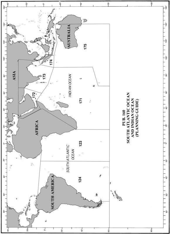
Pub. 160, Sailing Directions (Planning Guide) South Atlantic Ocean and Indian Ocean, Thirnd Edition, 2004, is issued for use in conjunction with the following Sailing Directions (Enroute) Publications:
Pub. 123, Pub. 124, Pub. 171, Pub. 172, Pub. 173, Pub. 174, and Pub. 175.
This publication has been corrected to 3 April 2004, including Notice to Mariners No. 14 of 2004.
Copyright.— Copyright 2004 by the United States Government. No copyright claimed under Title 17 U.S.C.
Explanatory Remarks
Sailing Directions are published by the National GeospatialIntelligence Agency (NGA) under the authority of Department of Defense Directive 5105.40, dated 12 December 1988, and pursuant to the authority contained in U. S. Code Title 10, Sections 2791 and 2792 and Title 44, Section 1336. Sailing Directions, covering the harbors, coasts, and waters of the world, provide information that cannot be shown graphically on nautical charts and is not readily available elsewhere.
Sailing Directions (Planning Guide) are intended to assist mariners in planning ocean passages and to eliminate duplication by consolidating useful information about all the countries adjacent to a particular ocean basin in one volume.
Planning Guide publications are compiled and structured in the alphabetical order of countries contained within the region covered by each publication.
Bearings.— Bearings are true, and are expressed in degrees from 000˚ (north) to 360˚, measured clockwise. General bearings are expressed by the initial letters of the points of the compass (e.g. N, NNE, NE, etc.). Adjective and adverb endings have been discarded. Wherever precise bearings are intended, degrees are used.
Corrective Information.— Corrective information and other comments about this publication can be forwarded to NGA, as follows:
1. Mailing address—
Maritime Safety Information Division ST D 44
National Geospatial-Intelligence Agency 4600 Sangamore Road
Bethesda MD 20816-5003 2. E-mail address—
sdpubs@nga.mil
New editions of Sailing Directions are corrected through the date of publication shown above. Important information to amend material in the publication is available as a Publication Digital Update (PDU) from the NGA Maritime Safety Information Division website.
NGA Maritime Safety Information Division
Website (PDUs)
http://164.214.12.145/sdr
Courses.— Courses are true, and are expressed in the same manner as bearings. The directives “steer” and “make good” a course mean, without exception, to proceed from a point of origin along a track having the identical meridional angle as the designated course. Vessels following the directives must allow for every influence tending to cause deviation from such track,
and navigate so that the designated course is continuously being made good.
Currents.— Current directions are the true directions toward which currents set.
Distances.— Distances are expressed in nautical miles of 1 minute of latitude. Distances of less than 1 mile are expressed in meters, or tenths of miles.
Geographic Names.— Geographic names are generally those used by the nation having sovereignty. Names in parentheses following another name are alternate names that may appear on some charts. In general, alternate names are quoted only in the principal description of the place. Diacritical marks, such as accents, cedillas, and circumflexes, which are related to specific letters in certain foreign languages, are not used in the interest of typographical simplicity.
Geographic names or their spellings do not necessarily reflect recognition of the political status of an area by the United States Government.
Heights.— Heights are referred to the plane of reference used for that purpose on the charts and are expressed in meters.
Internet Links.— This publication provides Internet links to web sites concerned with maritime navigational safety, including but not limited to, Federal government sites, foreign Hydrographic Offices, and foreign public/private port facilities. NGA makes no claims, promises, or guarantees concerning the accuracy, completeness, or adequacy of the contents of these web sites and expressly disclaims any liability for errors and omissions in the contents of these web sites.
Lights and Fog Signals.— Lights and fog signals are not described, and light sectors are not usually defined. The Light Lists should be consulted for complete information.
National Ocean Claims.— Information on national ocean claims, which has been compiled from the best available sources, is provided solely in the interest of the navigational safety of shipping and in no way constitutes legal recognition by the United States. These non-recognized claims and requirements may include, but are not limited to:
1.A requirement by a state for advance permission or notification for innocent passage of warships in the territorial sea.
2.Straight baseline, internal waters, or historic waters claims.
3.The establishment of a security zone, where a state claims to control activity beyond its territorial sea for security reasons unrelated to that state’s police powers in its territory, including its territorial sea.
Radio Navigational Aids.— Radio navigational aids and
radio weather services are not described in detail. Publication No. 117 Radio Navigational Aids and NOAA Publication, Selected Worldwide Marine Weather Broadcasts, should be consulted.
Sales.— For sale by the Superintendent of Documents, U.S. Government Printing Office, Mail Stop: SSOP, Washington, DC 20402-0001. Phone: toll free (866) 512-1800, DC area (202) 512-1800.
GPO Bookstore Website
http://bookstore.gpo.gov
Soundings.— Soundings are referred to the datum of the charts and are expressed in meters.
Pub. 160 |
III |

Special Warnings.— Special Warnings may be in force for the geographic area covered by this publication. Special Warnings are printed in the weekly Notice to Mariners upon promulgation and are reprinted annually in Notice to Mariners No. 1. A listing of Special Warnings currently in force is printed in each weekly Notice to Mariners, Section III, Broadcast Warnings, along with the notice number of promulgation. Special Warnings are also available on the Maritime Safety Information Division website.
NGA Maritime Safety Information Division
Website (Special Warnings)
http://164.214.12.145warn/warn_j_query.html
Time Zone.— The Time Zone description(s), as well as information concerning the use of Daylight Savings Time, are included. The World Time Zone Chart is available on the Internet at the website given below.
World Time Zone Chart http://www.odci.gov/cia/publications/factbook/ reference_maps/pdf/time_zones.pdf
Winds.— Wind directions are the true directions from which winds blow.
Reference List
The principal sources examined in the preparation of this publication were:
British Hydrographic Department Sailing Directions. Argentina Sailing Directions.
Brazil Sailing Directions. South Africa Sailing Directions.
Fairplay Ports and Terminals, 2003. The Statesman’s Yearbook, 2003. The World Factbook, 2003.
Reports from United States Naval and merchant vessels and various shipping companies.
Other U.S. Government publications, reports, and documents.
Charts, light lists, tide and current tables, and other documents in possession of the Agency.
Internet Web sites, as follows:
1.Department of State/U.S. Embassies. http://usembassy.state.gov
2.IMB Piracy Reporting Center Home Page. http://www.iccwbo.org/ccs/menu_imb_piracy.asp
3.World Factbook. http://www.odci.gov/cia/publications/factbook
IV |
Pub. 160 |

Contents
Page
How to Keep this Book Corrected . . . . . . . . . . . . . . . . . . . . . . . . . . . . . . . . . . . . . . . . . . . . . . . . . . . . . . . . . . . . . . . . . . . . . . . . . . . II Preface. . . . . . . . . . . . . . . . . . . . . . . . . . . . . . . . . . . . . . . . . . . . . . . . . . . . . . . . . . . . . . . . . . . . . . . . . . . . . . . . . . . . . . . . . . . . . . . . III Chartlet—Sector Limits . . . . . . . . . . . . . . . . . . . . . . . . . . . . . . . . . . . . . . . . . . . . . . . . . . . . . . . . . . . . . . . . . . . . . . . . . . . . . . . . . VII Conversion Tables. . . . . . . . . . . . . . . . . . . . . . . . . . . . . . . . . . . . . . . . . . . . . . . . . . . . . . . . . . . . . . . . . . . . . . . . . . . . . . . . . . . . . VIII Sailing Directions Information and Suggestion Sheet . . . . . . . . . . . . . . . . . . . . . . . . . . . . . . . . . . . . . . . . . . . . . . . . . . . . . . . . . . . IX Abbreviations . . . . . . . . . . . . . . . . . . . . . . . . . . . . . . . . . . . . . . . . . . . . . . . . . . . . . . . . . . . . . . . . . . . . . . . . . . . . . . . . . . . . . . . . . . XI
COUNTRIES
ANGOLA . . . . . . . . . . . . . . . . . . . . . . . . . . . . . . . . . . . . . . 1 ARGENTINA. . . . . . . . . . . . . . . . . . . . . . . . . . . . . . . . . . . 3 AUSTRALIA . . . . . . . . . . . . . . . . . . . . . . . . . . . . . . . . . . . 9 BAHRAIN . . . . . . . . . . . . . . . . . . . . . . . . . . . . . . . . . . . . 35 BANGLADESH . . . . . . . . . . . . . . . . . . . . . . . . . . . . . . . . 37 BENIN . . . . . . . . . . . . . . . . . . . . . . . . . . . . . . . . . . . . . . . 39 BRAZIL . . . . . . . . . . . . . . . . . . . . . . . . . . . . . . . . . . . . . . 41 BURMA . . . . . . . . . . . . . . . . . . . . . . . . . . . . . . . . . . . . . . 49 CAMEROON . . . . . . . . . . . . . . . . . . . . . . . . . . . . . . . . . . 51 COMOROS . . . . . . . . . . . . . . . . . . . . . . . . . . . . . . . . . . . 53 CONGO, DEMOCRATIC REPUBLIC OF . . . . . . . . . . . 57 CONGO, REPUBLIC OF . . . . . . . . . . . . . . . . . . . . . . . . 59 DJIBOUTI . . . . . . . . . . . . . . . . . . . . . . . . . . . . . . . . . . . . 61 EGYPT . . . . . . . . . . . . . . . . . . . . . . . . . . . . . . . . . . . . . . . 63 EQUATORIAL GUINEA . . . . . . . . . . . . . . . . . . . . . . . . 67 ERITREA . . . . . . . . . . . . . . . . . . . . . . . . . . . . . . . . . . . . . 69 FALKLAND ISLANDS. . . . . . . . . . . . . . . . . . . . . . . . . . 71 FRENCH GUIANA . . . . . . . . . . . . . . . . . . . . . . . . . . . . . 75 GABON . . . . . . . . . . . . . . . . . . . . . . . . . . . . . . . . . . . . . . 79 GHANA . . . . . . . . . . . . . . . . . . . . . . . . . . . . . . . . . . . . . . 81 GUYANA. . . . . . . . . . . . . . . . . . . . . . . . . . . . . . . . . . . . . 83 INDIA. . . . . . . . . . . . . . . . . . . . . . . . . . . . . . . . . . . . . . . . 87 INDIAN OCEAN . . . . . . . . . . . . . . . . . . . . . . . . . . . . . . 105 INDONESIA . . . . . . . . . . . . . . . . . . . . . . . . . . . . . . . . . 113 IRAN . . . . . . . . . . . . . . . . . . . . . . . . . . . . . . . . . . . . . . . 117 IRAQ . . . . . . . . . . . . . . . . . . . . . . . . . . . . . . . . . . . . . . . 121 ISRAEL . . . . . . . . . . . . . . . . . . . . . . . . . . . . . . . . . . . . . 127 IVORY COAST . . . . . . . . . . . . . . . . . . . . . . . . . . . . . . . 131 JORDAN . . . . . . . . . . . . . . . . . . . . . . . . . . . . . . . . . . . . 133
KENYA . . . . . . . . . . . . . . . . . . . . . . . . . . . . . . . . . . . . . . 135 KUWAIT. . . . . . . . . . . . . . . . . . . . . . . . . . . . . . . . . . . . . 137 MADAGASCAR . . . . . . . . . . . . . . . . . . . . . . . . . . . . . . 139 MALAYSIA . . . . . . . . . . . . . . . . . . . . . . . . . . . . . . . . . . 143 MALDIVES . . . . . . . . . . . . . . . . . . . . . . . . . . . . . . . . . . 147 MAURITIUS. . . . . . . . . . . . . . . . . . . . . . . . . . . . . . . . . . 149 MOZAMBIQUE . . . . . . . . . . . . . . . . . . . . . . . . . . . . . . . 151 NAMIBIA . . . . . . . . . . . . . . . . . . . . . . . . . . . . . . . . . . . . 155 NIGERIA . . . . . . . . . . . . . . . . . . . . . . . . . . . . . . . . . . . . 159 OMAN. . . . . . . . . . . . . . . . . . . . . . . . . . . . . . . . . . . . . . . 163 PAKISTAN . . . . . . . . . . . . . . . . . . . . . . . . . . . . . . . . . . . 167 PARAGUAY. . . . . . . . . . . . . . . . . . . . . . . . . . . . . . . . . . 173 QATAR . . . . . . . . . . . . . . . . . . . . . . . . . . . . . . . . . . . . . . 175 SAO TOME AND PRINCIPE . . . . . . . . . . . . . . . . . . . . 179 SAUDI ARABIA . . . . . . . . . . . . . . . . . . . . . . . . . . . . . . 181 SEYCHELLES . . . . . . . . . . . . . . . . . . . . . . . . . . . . . . . . 185 SINGAPORE . . . . . . . . . . . . . . . . . . . . . . . . . . . . . . . . . 187 SOMALIA. . . . . . . . . . . . . . . . . . . . . . . . . . . . . . . . . . . . 195 SOUTH AFRICA . . . . . . . . . . . . . . . . . . . . . . . . . . . . . . 197 SOUTH ATLANTIC OCEAN . . . . . . . . . . . . . . . . . . . . 209 SRI LANKA . . . . . . . . . . . . . . . . . . . . . . . . . . . . . . . . . . 215 SUDAN . . . . . . . . . . . . . . . . . . . . . . . . . . . . . . . . . . . . . . 219 SURINAME . . . . . . . . . . . . . . . . . . . . . . . . . . . . . . . . . . 221 TANZANIA . . . . . . . . . . . . . . . . . . . . . . . . . . . . . . . . . . 223 THAILAND . . . . . . . . . . . . . . . . . . . . . . . . . . . . . . . . . . 225 TOGO . . . . . . . . . . . . . . . . . . . . . . . . . . . . . . . . . . . . . . . 229 UNITED ARAB EMIRATES . . . . . . . . . . . . . . . . . . . . . 231 URUGUAY . . . . . . . . . . . . . . . . . . . . . . . . . . . . . . . . . . . 233 YEMEN. . . . . . . . . . . . . . . . . . . . . . . . . . . . . . . . . . . . . . 237
Pub. 160 |
V |
Pub. 160 |
VII |