

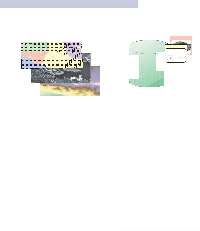
RASTER DATA
Rasters are used to represent continuous layers, such as elevation, slope and aspect, vegetation, temperature, rainfall, plume dispersion, and so on. Rasters are most commonly used for aerial photographs and imagery of various kinds.
Grass |
Shrub |
Beach |
Forest |
Water |
In addition to vector features and raster datasets, all other spatial data types can be managed and stored in the relational tables as well, allowing you the opportunity to manage all geographic data in a DBMS.
Imagery
Surveys
Addresses 

Rules & behavior


 Topology
 Terr
Terr ain
ain
Networks |
H |
Geodatabases are used to manage and store diverse collections of geographic information types.
The ArcGIS geodatabase • 25
GEODATABASE STORAGE IN RELATIONAL DATABASES
Geodatabase storage includes the schema and rule base for each geographic dataset as well as the spatial and attribute data. All of the data is stored in the DBMS in tables.
The Geodatabase Schema includes the definitions, integrity rules, and behavior for each geographic dataset. These include properties for feature classes, topologies, networks, raster catalogs, relationships, domains, etc. The schema is persisted in a collection of geodatabase metatables in the DBMS that define the integrity and behavior of the geographic information.
The spatial representations are most commonly stored as either vector features or as raster datasets along with traditional tabular attributes. For example, a DBMS table can be used to store a feature collection where each row in the table represents a feature. A shape column in each row is used to hold the geometry or shape of the feature. The shape column holding the geometry is typically one of two column types:
•A binary large object (BLOB) column type
•A spatial column type, if the DBMS supports it
A homogenous collection of common features, each having the same spatial representation (such as a point, line, or polygon) and a common set of attribute columns is referred to as a feature class and is managed in a single table.
Raster and imagery data types are managed and stored in relational tables as well. Raster data is typically much larger in size and requires a side table for storage. The raster is cut into smaller pieces, called “blocks”, and stored in individual rows in the separate block table.
The column types that hold the vector and raster geometry vary from database to database. When the DBMS supports spatial type extensions, the geodatabase can readily use them to hold the spatial geometry. ESRI was closely involved in efforts to extend SQL for spatial as the primary authors of the SQL 3 MM Spatial and the OGC Simple Features SQL specifications. ESRI has focused on support for these types, as well as the independent Oracle Spatial types, in the persistence of geodatabases using DBMS standards.
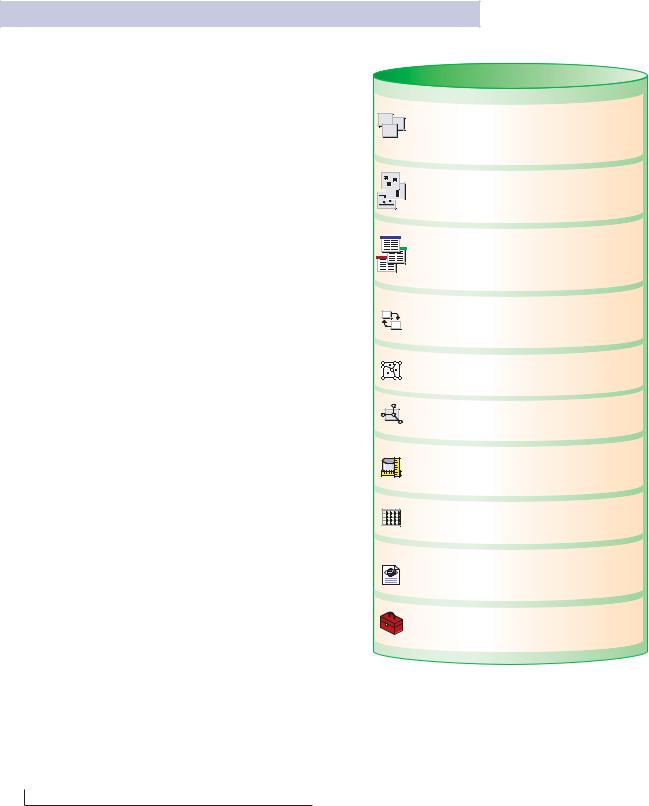
Feature Dataset
Contains spatially-related feature classes together with
the topology and network objects that bind them. Feature classes in a feature dataset have
spatial reference.
Feature class


 A table with a shape field containing point, line, or
  polygon geometries for geographic features. Each row is a feature.
Table
A collection of rows, each containing the same fields.
Feature classes are tables with shape feilds.
Domain
Defines a set or range of valid values for a field.
Relationship class
Associates objects from a feature class or table to objects in another feature class or table. Relationship classes can optionally have user-defined fields.
Topology
Integrity rules that define the behavior of geographically-integrated features.
Geometric network
Rules for managing connectivity among features in a set of feature classes.
Survey dataset
Contains survey measurements which are used to calculate coordinates linked to feature geometries in survey-aware feature classes.
Raster dataset
Contains rasters which represent continous geographic phenomena.
Metadata document
An XML document that can be associated with every dataset, commonly used in ArcIMS and other
server applications.
Geoprocessing tools
A collection of dataflow and workflow processes for performing data managment, analysis, and modeling.
A geodatabase is a store of geographic data implemented with the relational database of your choice. All geodatabase elements are managed in standard DBMS tables using standard SQL data types. These are some of the structural elements of a geodatabase that you will use to develop your geographic data model.
26 • Understanding ArcSDE
VERSIONED GEODATABASES AND DISTRIBUTED WORK FLOWS
GIS data, like other information, must be continually maintained and edited. Hence, geodatabases are designed to be transactional. The geodatabase was designed from the beginning to be edited by many users, to scale to very large, continuous sizes, and support a number of common GIS application scenarios.
GIS data compilation work flows and data sharing require a long transaction model for numerous editing and data replication needs. A long transaction in the GIS context is one that spans multiple days or even weeks, even when the user disconnects from the database. In the DBMS context, transactions are short in the sense that no DBMS transaction persists when the user disconnects from the database.
In GIS, a single edit operation is typically combined with a series of other edits to define a complete transaction. For example, a typical update in land records applications is a “parcel split”. This involves three steps: deleting the old parcel, creating two new parcels, and updating the tax rolls with new corresponding parcel and owner information. In this simple case, a single GIS update transaction is actually composed of three or more DBMS transactions. In addition, GIS users often need to:
•UNDO-REDO individual editing operations during an editing session.
•Create a historical archive of updated features (for example, “retired” parcels and their lineages).
In a multiuser database, the GIS transactions must be orchestrated on the DBMS’s short transaction framework. ArcSDE plays a key role during these operations by managing the higher-level complex GIS transactions on the short duration DBMS transaction framework.
GIS users have many such cases where long transaction workflows are critical. In most cases, these are made possible through the use of a multiuser DBMS and ArcSDE for managing updates to the central GIS database:
•Multiple edit sessions. A single GIS database update may require numerous changes that span multiple edit sessions occuring over a few days or weeks.
•Multiuser editing. Multiple editors often need to concurrently update the same spatially integrated features. Each needs to work with his or her own database state, viewing their own individual updates and ignoring updates by other editors. Eventually each user needs to post their updates and to reconcile their updates with the other editors as well as to identify and resolve any conflicts.
•Check-out, Check-in Transactions. Often users might want to checkout a portion of a database for a particular area or district onto their own computer and update that information in a disconnected session that might last for days or weeks. Eventually, they wish to post their updates to the main database. In other cases, users will take a portion of a large geodatabase with them into the field for validation and update with field computers.
•History. Some users want to maintain a historical version of each feature that was in their GIS database, even after that version has been updated. They want to maintain a copy of the retired and changed features in a historical archive. Users also often need to track each individual feature’s history (for example, parcel lineage or feature update properties in a national mapping database).
•Transfer of change-only updates. Many users collaborate on data collection and need to share updates (across the World Wide Web) in a well-defined XML schema for sharing change-only updates between databases. These databases can have different GIS architectures.
•Loosely coupled replication across DBMS’s. Often users want to periodically synchronize GIS data contents among a series of database copies (called replicas), where each site performs its own updates on its local database. Periodically the users want to transfer the updates from each database replica to the others and to synchronize their contents. Many times the DBMS’s are different (e.g., to replicate datasets between SQL Server, Oracle, and IBM DB2).
The ArcGIS geodatabase • 27

What is versioning?
The geodatabase mechanism for managing these and many other critical GIS workflows is to maintain multiple states in the geodatabase, and most importantly, to do so while ensuring the integrity of the GIS database. This ability to manage and view multiple states and to work with them is based on versioning. Versioning, as the name implies, explicitly records versions of individual features and objects as they are modified, added, and “retired” through various states. A version explicitly records each state of a feature or object as a row in a table along with important transaction information.
Versions explicitly record the object states of a geodatabase in delta tables called the “Adds” table and the “Deletes” table. Simple queries are used to view (and
work with) any desired state of the geodatabase. For example, to view the database state for a point in time or to see a particular user’s current version with his or her edits.
This delta table schema is used to support simultaneous editing of datasets as well as numerous version-based GIS workflows such as the examples described earlier for multiple edit sessions, history, cross-DBMS replication, and so forth.
ArcSDE plays a critical role in versioned Geodatabase applications and is used to manage long transactions in each DBMS as well as across different systems.
The goal of versioning is to support these and many other critical GIS data workflows to enable enterprise GIS implementations.
Default version
State 1 version
Base table
ID |
|
Shape |
|
Area |
Coverage |
R-ID |
|
|
|
|
|
|
|
|
|
|
|
|
|
|
1 |
|
|
|
15 |
vegi. |
10 |
|
|
|
||||
|
|
|
|
|
|
|
|
|
|
|
|
|
|
2 |
|
|
|
30 |
Indust. |
20 |
|
|
|
|
|
|
|
3 |
|
|
|
14 |
resident |
30 |
|
|
|
|
|
|
|
4 |
|
|
|
12 |
water |
40 |
|
|
|
|
|
|
|
5 |
|
|
|
25 |
grove |
50 |
|
|
|
|
|
|
|
Delete table
ID Shape Area Coverage R-ID
2 |
30 |
Indust. |
20 |
Add table
ID Shape Area Coverage R-ID
6 |
17 |
Indust. |
60 |
7 |
13 |
vegi. |
70 |
28 • Understanding ArcSDE

4 The ArcSDE
architecture
ArcSDE provides a means to deliver data from a DBMS to GIS applications. It has a particular architecture with configuration options that are important for database administrators and application developers to know.
In this chapter:
• What is an application server?
• Direct connections
• Connecting with a direct connect driver
• Licensing and Authorization