

RASTER TABLES
Raster data represents a significant portion of the total data used in a GIS. ArcSDE provides support for rasters in a number of different formats.
ArcSDE handles raster data much like vector data. When a business table is created with a column of raster type, ArcSDE will reference this raster column as a raster dataset. Raster catalogs can have multiple rasters. Information about the raster column is maintained in one of the ArcSDE system tables called raster_columns.
Here’s a brief description of the tables in raster layer schema.
For each raster type column in a business table, ArcSDE will automatically create four additional tables. They are:
Metadata table for raster (SDE_RAS_<id#>)
Metadata table for raster band (SDE_BND_<id#>)
Auxiliary table for raster band (SDE_AUX_<id#>)
Block table (SDE_BLK_<id#>)
The first two metadata tables are used to store information about a raster and a raster band such as the raster dimensions and the pixel depth.
The auxiliary table is used to save additional information about a raster band such as a colormap and raster statistics. The block table is where the actual pixel blocks are stored.
city_photo
name image
SDE_ras_6
raster_id raster_flags description
SDE_bnd_6
rasterband_id sequence_nbr raster_id name band_flags band_width band_height bahd_types block_width block_height block_origin_x block_origin_y
SDE_aux_6
rasterband_id type
object
SDE_blk_6
rasterband_id rrd_factor row_nbr col_nbr block_data
The 6 at the end of a table name is the internal registration ID number.
Tables |
that |
define |
an ArcSDE raster feature class. In this example, city_photo is the feature class users would see to |
add to |
their |
map. |
Users do not need to be aware of the existence of the other tables. |
Data storage • 17

3 The ArcGIS
geodatabase
The previous chapter provided the basics of how ArcSDE stores data in a DBMS as simple features. The purpose of this chapter is to introduce the ArcGIS geodatabase. The ArcSDE simple features provide the foundation for the ArcGIS geodatabase. In this chapter:
• The ArcGIS database
• What is the ArcGIS geodatabase?
• Geodatabase architecture
• Geodatabase application logic
• Vector and raster data
• Geodatabase storage
• Versioned geodatabases
19
THE ARCGIS GEODATABASE
ArcGIS supports GIS data in files and DBMSs
A key cornerstone of ArcGIS is the ability to access GIS data in any format and to use multiple databases and file bases concurrently.
ArcGIS has a high-level generic geographic data model for representing spatial information as features, rasters, and other spatial data types. ArcGIS supports an implementation of the data model for both file systems and relational database management systems. The support for spatial data in a DBMS is via ArcSDE.
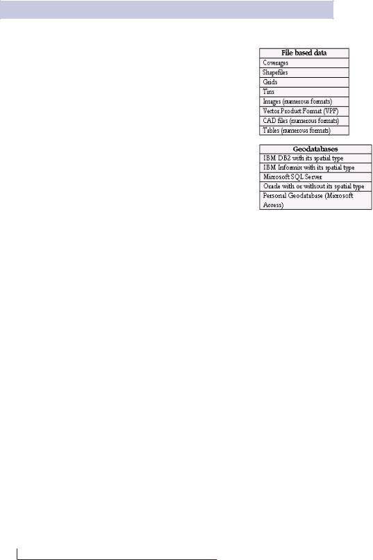
Support for file-based models includes access to numerous GIS datasets such as coverages, shapefiles, grids, images, and triangulated irregular networks. The geodatabase model manages the same types of geographic information in a relational database.
Both the file-based datasets and the DBMS-based datasets define a generic model for geographic information. This generic model can be used to define and work with a wide variety of GIS applications. By defining and implementing the behavior of a generic geographic data model, geographic information in ArcGIS can be multipurpose, shareable, and standards based. Most important, a comprehensive series of tools are available to work with the generic data types. Thus, ArcGIS provides a robust platform for virtually any GIS application.
Some of the common GIS data formats that can be used directly in ArcGIS. Access to and from numerous additional formats is supported through data conversion and interoperability extensions.
20 • Understanding ArcSDE