

ARCSDE CONNECTION CONFIGURATION OPTIONS
The ArcSDE gateway can be multitier and will run as part of a GIS client application or in a centralized server. ArcSDE can be flexibly configured to connect client applications directly to a DBMS (a two tier configuration) or to run as an application server near the DBMS (a three tier configuration). There are advantages to each configuration, depending on your needs.
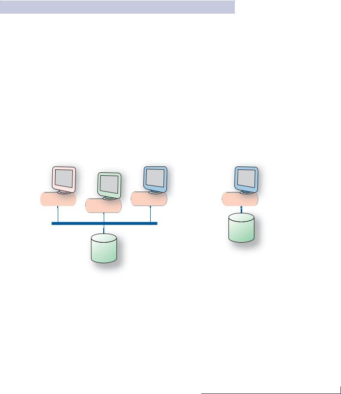
Direct connection configuration
This configuration is useful in many situations because it allows for increased scalability by offloading work from the server to each connected client. It also can be useful in many failover environments because it reduces the number of single points of failure.
Application server configuration
Currently, the most common ArcSDE configuration includes an ArcSDE Application Server. The application server allows you to serve geographic data from a large, central geodatabase on UNIX, Linux®, and Windows servers. The ArcSDE Application Server is typically located on the same hardware platform as your DBMS, ArcIMS, or ArcGIS Server. The application server configuration can offer performance advantages; during editing, it may be faster due to the intelligent client/server data communications.
See Chapter 4, The ArcSDE Architecture, for more information about two-tier and three-tier configurations.
ArcView |
ArcInfo |
ArcInfo |
|
ArcEditor |
|
ArcSDE |
ArcSDE |
ArcSDE |
|
ArcSDE |
|
DBMS
DBMS
ArcSDE has both a direct connection configuration and an application server configuration, as shown in the graphics above.
Introducing ArcSDE • 5

ARCSDE FOR DEVELOPERS
ArcSDE comes with high-level APIs for querying and working with information in geodatabases. These include:
•ArcSDE Client API for C and Java developers
•COM API (ArcObjects) for use with the ArcGIS suite of products
ArcSDE Client API
ArcSDE ships with an ArcSDE Developer Kit CD–ROM. This CD–ROM has C and Java SDK from which applications can be built. The ArcSDE Client API provides many advanced GIS functions. All ESRI client applications that work with the ArcSDE gateway (for example, ArcGIS) use either the C or Java API. ArcSDE client applications, such as ArcGIS, are large and use a great deal of the available ArcSDE API. If you are building custom applications from one of these ESRI products (for example, ArcGIS Engine), you won’t need to use the C or Java API. You’ll use ArcObjects (with one of the ArcGIS Application Development Frameworks). Non-ESRI client applications can be built using a small portion of the API to build small, focused, mission-critical applications—for example, in emergency response and customer care.
These two ArcSDE APIs allow developers to build custom applications to work with any DBMS supported by ArcSDE. ArcSDE has a significant third-party developer community providing application solutions for many industries.
ArcObjects
If you want to build or customize an ArcGIS application, you’ll use ArcObjects. ArcObjects is the COM developer’s API for ArcGIS Desktop, Server, and Engine. It provides the ability to access and work with the contents of ArcGIS geodatabases as objects with advanced GIS behavior and relationships. A Java ADF and a .Net ADF are available for use with ArcObjects. Refer to ArcGIS documentation for more information on ArcObjects development.
SQL
There are SQL APIs available for working with spatial data. The SQL interface provided by your DBMS can be used to work with the contents of spatial databases. Since spatial databases use standard DBMS columns, the DBMS’s SQL API is used. For a spatially enabled DBMS (IBM DB2, IBM Informix, and Oracle Spatial/Locator), a SQL API is available to perform spatial queries directly in the database. This allows SQL query access to feature geometry using DBMS applications. See your host DBMS documentation for spatial query SQL syntax.
6 • Understanding ArcSDE
2 Data
storage
This chapter is targeted for database administrators and application developers and provides an overview of the ArcSDE simple feature model and how data is stored.
In this chapter:
• Using a DBMS
• Organizing features
• Types of features
• Feature storage
• Geometry storage options
• Spatial indexing
• Relational access and object relational access
• Vector tables and Raster tables
7

DATA STORAGE WITHARCSDE
This chapter reviews the basics of the ArcSDE simple feature model and how the data is physically stored in the DBMS. This chapter is an important building block for understanding the overview of the ArcGIS geodatabase in Chapter 3.
The first thing you should know is that data is never stored in ArcSDE. Data is stored in tables in a DBMS. ArcSDE is the tool that allows you to use that data with GIS applications.
Second, all data is stored in standard DBMS tables using data types available for the host database. ArcSDE uses and complements the base DBMS capability by adding a spatial component to the database. A key part of using ArcSDE is tuning the host DBMS. There can be many performance variables, but ArcSDE performance hinges largely on how well the host database is tuned.
Key DBMS concepts
In a relational database management system model, data is stored in tables consisting of rows and columns. The cell defined by the intersection of a row and column is called a field; the data contained in the field is a value. A row represents a particular occurrence, or instance, of a feature, while the columns contain the attributes of the feature, such as owner name for a parcel. Attributes can have many types, such as dates, text strings, or numbers. A geometric shape of a feature is another type of value, stored in a column that defines an abstract geometric data type.
SQL provides an interface to relational tables that allows you to select rows based on the values contained in the fields. A SQL statement can range from simple to complex, allowing you to compose virtually any type of query from basic column types.
A query may return columns from any number of tables by joining the tables together on key columns. A primary key (one or more columns) uniquely identifies rows in a table. The same column or columns, duplicated in another table, is called the foreign key. These keys allow tables to be joined.
The result of a query is a set of rows meeting the criteria established by the SQL statement. This set is called a cursor. An application can reference a number of active cursors. The application proceeds through a cursor, looking at each individual row. As each successive row is
requested, the appropriate values of each field are made available to the application.
ArcSDE extends SQL by providing tools to work with spatial data. You can also use standard SQL queries in ArcSDE API to perform attribute-only queries.
|
|
|
|
|
|
|
|
|
|
|
|
|
|
|
|
|
object identifier |
|
|
|
|
|
|
|
|
|
|
|
|
|
|
|
|
|
|
geometry |
|
|
|
|
|
|
|
|
|
|
|
|
|
|
|
|
|
|
geometry-tracking field |
|
|
|
|
|
|
|
|
|
|
|
|
|
|
|
|
|
|
coded value |
|
|
|
|
|
|
|
|
|
|
|
|
|
|
|
|
|
|
descriptive string |
|
|
|
|
|
|
|
|
|
|
|
|
|
|
|
|
|
|
continuous numeric value |
|
|
|
|
|
|
|
|
|
|
|
|
|
|
|
|
|
|
||
|
|
|
|
|
|
|
|
|
|
|
|
|
|
|
|
|
discrete numeric value |
|
|
|
|
|
|
|
|
|
|
|
|
|
|
|
|
|
|
name |
|
|
|
|
|
|
|
|
|
|
|
|
|
|
|
|
|
|
|
|
|
|
|
|
|
|
|
|
|
|
|
|
|
|
|
|
|
|
|
|
fid |
geom |
shp_len |
type |
surface |
width |
lanes |
name |
|
|||||||||
|
101 |
|
|
4507.2 |
2 |
asphalt |
85.3 |
4 |
Old Taos Highway |
|
||||||||
|
102 |
|
|
3401.1 |
1 |
concrete |
45.1 |
2 |
Calle Mejia |
|
||||||||
|
103 |
|
|
2321.8 |
3 |
asphalt |
75.9 |
4 |
Caitlin County Road |
|
||||||||
|
104 |
|
|
689.2 |
5 |
gravel |
35.2 |
2 |
Max Daniel Road |
|
||||||||
|
|
|
|
|
|
|
|
|
|
|
|
|
|
|
|
|
foreign key |
|
|
|
|
|
|
|
|
|
|
|
|
|
|
|
|
|
|
||
|
|
|
|
|
|
|
|
|
|
|
|
|
|
|
|
|
primary key |
|
|
|
|
|
|
|
|
|
|
|
|
|
|
|
|
|
|
||
|
|
|
|
|
|
|
|
|
|
|
|
|
|
|
|
|
|
|
|
|
|
|
|
|
|
|
|
|
|
|
|
|
|
|
|
|
|
|
|
|
|
|
|
|
|
|
|
|
code |
description |
|
|||||
|
|
|
|
|
|
|
|
|
|
|
1 |
divided highway |
|
|||||
|
|
|
|
|
|
|
|
|
|
|
2 |
arterial or collector roads |
|
|||||
|
|
|
|
|
|
|
|
|
|
|
3 |
major roads |
|
|||||
|
|
|
|
|
|
|
|
|
|
|
4 |
residential streets |
|
|||||
|
|
|
|
|
|
|
|
|
|
|
5 |
unpaved roads |
|
|||||
|
|
|
|
|
|
|
|
|
|
|
|
|
|
|
|
|
|
|
8 • Understanding ArcSDE