

Getting Started With ArcIMS
Copyright © 2004 ESRI
All Rights Reserved.
Printed in the United States of America.
The information contained in this document is the exclusive property of ESRI. This work is protected under United States copyright law and other international copyright treaties and conventions. No part of this work may be reproduced or transmitted in any form or by any means, electronic or mechanical, including photocopying or recording, or by any information storage or retrieval system, except as expressly permitted in writing by ESRI. All requests should be sent to Attention: Contracts Manager, ESRI, 380 New York Street, Redlands, CA 92373-8100, USA.
The information contained in this document is subject to change without notice.
U.S.GOVERNMENTRESTRICTED/LIMITEDRIGHTS
Any software, documentation, and/or data delivered hereunder is subject to the terms of the License Agreement. In no event shall the U.S. Government acquire greater than RESTRICTED/LIMITED RIGHTS. At a minimum, use, duplication, or disclosure by the U.S. Government is subject to restrictions as set forth in FAR §52.227-14 Alternates I, II, and III (JUN 1987); FAR §52.227-19 (JUN 1987) and/ or FAR §12.211/12.212 (Commercial Technical Data/Computer Software); and DFARS §252.227-7015 (NOV 1995) (Technical Data) and/or DFARS §227.7202 (Computer Software), as applicable. Contractor/Manufacturer is ESRI, 380 New York Street, Redlands, CA 92373-8100, USA.
ESRI, ArcExplorer, ArcGIS, ArcPad, ArcIMS, ArcMap, ArcSDE, Geography Network, the ArcGIS logo, the ESRI globe logo, www.esri.com, GIS by ESRI, and ArcCatalog are trademarks, registered trademarks, or service marks of ESRI in the United States, the European Community, or certain other jurisdictions.
Microsoft and the Windows logo are registered trademarks and the Microsoft Internet Explorer logo is a trademark of Microsoft Corporation.
Other companies and products mentioned herein are trademarks or registered trademarks of their respective trademark owners.

Contents
1 About ArcIMS and this guide 1 |
|
About ArcIMS |
2 |
ArcIMS documentation 14 |
|
Other available documents 18 |
|
About sample data and applications 19 |
|
Getting support |
20 |
2 |
Installation and startup |
21 |
||||
|
Installing ArcIMS |
23 |
|
|
|
|
|
Starting ArcIMS |
27 |
|
|
|
|
3 |
Quick-start tutorial 33 |
|
|
|||
|
Exercise 1: Creating a map for the Web |
34 |
||||
|
Exercise 2: Creating an Image Service |
39 |
||||
|
Exercise 3: Designing a Web site |
41 |
|
|||
|
Exercise 4: Viewing your Web site |
45 |
|
|||
4 |
Quick reference |
47 |
|
|
||
|
Author |
48 |
|
|
|
|
|
Designer |
52 |
|
|
|
|
|
Administrator 53 |
|
|
|
||
|
Service Administrator |
54 |
|
|
||
|
Viewers |
55 |
|
|
|
|
iii

About ArcIMS and this guide |
1 |
|
IN THIS CHAPTER
•About ArcIMS
•ArcIMS documentation
•Other available documents
•About sample data and applications
•Getting support
Welcome to ArcIMS® 9, ESRI’s powerful, scalable, extendable, standards-based software application for distributing maps on the Web. Using the Typical option in the ArcIMS installation and the ArcIMS HTML Viewer, you can quickly and easily create and deploy a Web site, or Internet geographic information system (GIS) application, that provides your maps to anyone with a Web browser, even if you’re new to creating Web sites.
This guide, part of a comprehensive ArcIMS documentation set, introduces you to ArcIMS and guides you through the process of getting all the necessary components installed, configured, and running for your particular environment. It is divided into the following chapters:
1.‘About ArcIMS and this guide’ gives a brief overview of ArcIMS and provides a description of and tells how to access each piece of the documentation set, other available documentation, and sample data and applications you can use to jump-start your Web site.
2.‘Installation and startup’ provides instructions and tips for installing ArcIMS for the first time, upgrading from a previous version, and starting ArcIMS.
3.‘Quick-start tutorial’ guides you through the process of creating an ArcIMS Web site from creating a map to testing your site functionality. It includes instructions for both Windows® and UNIX® /Linux® users.
4.‘Quick reference’ provides illustrations and descriptions of each of the major components of ArcIMS and their user interface items, such as their toolbars.
1

About ArcIMS
ArcIMS and data sharing
The tremendous growth in Internet use has resulted in an increased demand for the delivery of geographic data, maps, and applications over the Internet. ArcIMS was developed by ESRI to meet this growing demand.
ArcIMS lets you centrally build and deliver maps, data, and tools over the Internet. ArcIMS takes advantage of the Internet technology that makes it possible to share information and data with many users, either locally or around the world.
Using ArcIMS, your organization can author maps and publish them to a Web site of your own creation, complete with map navigation and query tools. Using the ArcIMS security features allows you to regulate access to the services you deliver over the Internet.
Established organizations can leverage their investment in data by using ArcIMS as their Internet delivery system. ArcGIS users can leverage their investment in ArcGIS® by using ArcMap™ as the authoring environment for maps delivered over the Internet. Emergent organizations can use ArcIMS to meet new business challenges. Regardless of the scale or complexity of their needs, all organizations benefit from the flexibility and scalability of ArcIMS.
ArcIMS, rooted in ESRI’s proven Internet map publishing technology, is a reflection of ESRI’s ongoing commitment to research and development. ArcIMS was developed to address a number of challenges including:
•Ease of use at a variety of skill levels
•Out-of-the-box usability, while providing a highly customizable environment
•Comprehensive suite of administration tools
•Open and scalable architecture
•Tighter integration with other ESRI products including ArcGIS
Ease of use at a variety of skill levels
ArcIMS has been designed for those new to Web site creation, expert Web developers, and a range of experience levels in between. While the ArcIMS user interface provides beginners with a quick and easy way to set up a basic Web site, the open architecture of ArcIMS allows experienced Web developers to create highly customized and functionally rich Web sites, or Internet GIS applications.
If you’re a beginner, you can use the ArcIMS user interface to quickly get your Web site established and to later administer your site. You’ll likely choose one of the ArcIMS Viewers—prebuilt Web site templates—instead of building a Web site or client on your own.
If you’re an advanced user, you may wish to customize one of these viewers or build a fully customized client. In addition to documents that help you customize ArcIMS Viewers, ArcIMS comes with several application programming interfaces (APIs), including Active Server Pages (ASP), .NET, Java™, and ColdFusion® . These APIs, also known as connectors, expose ArcIMS functions so that you can develop custom clients. They come with sample applications, also known as templates, to help jump-start your custom client development.
As an advanced user, you can take advantage of additional features not available in the user interface. You do this primarily by manually editing files, such as configuration and property files.
This section describes ArcIMS architecture and components and provides a look at key directories and files in the ArcIMS directory structure.
2 |
GETTING STARTED WITH ARCIMS |
ArcIMS architecture and component descriptions
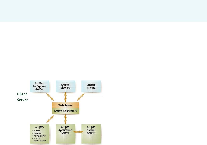
The ArcIMS architecture incorporates a processing model that uses many components working in cooperation to run simultaneously and create map data for delivery by the Web server. Components, communicating using standard protocols, can be distributed anywhere on the network while the components remain synchronized. Each host computer’s operating system controls the execution of ArcIMS processes and manages memory.
The ArcIMS Web site you create is composed of many components, even if you are using the Typical installation option and a simple configuration. The following diagram shows the server-side components required in the Typical installation option.
ArcIMS components, your Web server, and client applications. When your user’s Web browser opens your ArcIMS Web site, the browser is opening an ArcIMS Viewer or a custom client application.
ArcIMS Application Server
The ArcIMS Application Server provides the following functions to the Internet GIS application:
•Processes site administration requests. Typically these come from Administrator or Service Administrator.
•Distributes requests to the Spatial Server(s) and acts as a broker for these requests. It relies on Virtual Servers for this distribution. For more information on how the Spatial Server, the Application Server, Virtual Servers, and instances work together, see ‘Instances and Virtual Servers’ in this chapter.
•Tracks which ArcIMS services are running on which ArcIMS Spatial Servers.
•Logs information about the above tasks it performs.
ArcIMS Spatial Server
The ArcIMS Spatial Server is the core of ArcIMS. It hosts the ArcIMS services, processes requests for maps, retrieves attribute data, geocodes (matches addresses), and performs data extraction. The Spatial Server’s primary job is to dynamically render the map images that will be displayed on hypertext markup language (HTML) pages. It also generates site activity information, such as a log of any failed requests, and information about its processing, such as average request processing time, that you can review.
Because the Spatial Server’s workload is greater than that of any other ArcIMS component, you may need to place Spatial Servers on more than one machine. You can administer Spatial Servers with Administrator. One of the most important factors to consider when load balancing is the total number of instances in the Spatial Server.
ABOUT ARCIMS AND THIS GUIDE |
3 |

ArcIMS services
When you publish GIS content over the Internet or Intranet via ArcIMS, you must publish it through one or more ArcIMS services. An ArcIMS service is a process that continuously runs in the background and performs a specified operation at predefined times or in response to certain events.
An ArcIMS service presents spatial data and metadata to your users via a Web server. Items such as the symbology, labeling, and layer draw order for the service are defined in the configuration file. The configuration file is discussed later in this chapter.
Service types
ArcIMS has several types of services. Each service type corresponds to a Virtual Server type and Spatial Server function type. The service types are:
•Image Service—Maps are generated on the server and sent to clients in image formats such as Joint Photographic Experts Group (JPEG), Portable Network Graphics (PNG), and Graphics Interchange Format (GIF). A new map image is generated each time a client requests new information. Image Services have internal access to query, geocode, and extract functions. This internal access is possible through the Query, Geocode, and Extract Private Virtual Servers which are described in detail later. You will find that this service type can satisfy most of your Web site needs.
•Feature Service—Vector data is streamed to a Java applet in the requesting client. Feature streaming is a temporary compressed format that remains only as long as the client is open. Requests are sent to the Spatial Server only when additional data is needed. Similar to Image Services, Feature Services have internal access to query and geocode functions
through the Query and Geocode Private Virtual Servers. Use this service type when you want to take advantage of functions in the Java Viewers that require feature streaming such as changing layer symbology or EditNotes.
•ArcMap Image Service—This service lets you serve ArcMap and ArcGIS Publisher documents (.mxd files and .pmf files, respectively) over the Internet or Intranet via ArcIMS. When the Spatial Server receives a request, it generates a map and sends it to the client as a JPEG, PNG, or GIF image. A new map image is generated each time a client requests new information. ArcMap Image Services have internal access to query operations, but geocode and extract functions are not available. Use this service when you want to use versioned geodatabase data, you are seeking enhanced cartographic quality, or you already have a .mxd or .pmf file you want to publish.
•Metadata Service—This service allows users to search a metadata repository for documents related to mapping, data, and services. Use this service if you’ve created a metadata system.
•Route Services are also available if you’ve licensed the ArcIMS Route Server extension.
With the exception of restricting access (also known as user authentication), you manage your ArcIMS services using Administrator or its Web-based version, Service Administrator. When you manage services, you create, start, stop, and remove services. You also change service properties, such as the service description and the associated Virtual Server. As the Administrator user interface shows you as you’re managing services, different services require different information from you. For example, the Image Service requires an output directory location for the image file.
4 |
GETTING STARTED WITH ARCIMS |

Saving your site configuration ensures that your services are restored each time you reboot your machine or restart ArcIMS.
Organizing layers into services
An Internet GIS application can contain more than one Image or Feature Service. This gives you the flexibility to divide data layers into logical groups. Each group constitutes a single service. Dividing data layers into separate services can improve the organization of your site. The following list describes several ways to organize data layers into logical groups.
•Reusable—Maps often contain layers that are primarily used for reference. These referential data layers are used over and over again in different applications. You might create a service that includes only referential data layers.
•Domain specific—When data is specialized, you should consider assigning it to its own service. Corporate data, data requiring extensive analysis, and data to which you want to restrict access all fall into this category.
•Application specific—Some data layers are always used together to support a specialized application—for
example, waterlines, valves, and meters—and should be kept together in the same service.
•Frequently changing—Data layers that are frequently updated should be kept separate from layers that change infrequently. This prevents frequent updates from affecting data layers that only need infrequent changes.
•Detailed—Layers containing detailed information could be grouped together in the same service.
These are just a few examples of how categorizing your data can improve the organization of your application. You will discover many more practical divisions when you begin experimenting with your own applications and data.
Instances and Virtual Servers
An ArcIMS site must be able to respond quickly to various concurrent client requests. Some sites can do this effectively with the default Spatial Server and Virtual Server configuration. However, ArcIMS enables work to be distributed as needed through the use of Virtual Servers. In Spatial Server terms, work is defined by instances.
An instance, the fundamental processing unit of the Spatial Server, takes a request and generates a response that can be sent back to a client. An instance processes one request at a time.
The Spatial Server, a container for instances, is composed of different functions that handle the instances. Instances are handled via Virtual Servers based on which Spatial Server function they require.
The Spatial Server function types are:
•Image—Renders maps on the server-side and sends them to the client as Web-appropriate images. Provides ArcIMS Image Services.
•Feature—Streams requested vector data to the client. Provides ArcIMS Feature Services.
•Metadata—Lets clients search and browse geographic data about data.
•Query—Handles data queries.
•Geocode—Provides geocoding support.
•Extract—Sends requested data to client as zipped shapefiles.
•ArcMap Server—Publishes maps created in ArcMap. You must have installed the optional ArcMap Server component, which comes with ArcIMS.
ABOUT ARCIMS AND THIS GUIDE |
5 |

•Route Server—Calculates routes between a set of two or more stops. You must have licensed the optional Route Server extension to ArcIMS.
Virtual Servers help the Spatial Server (or a group of Spatial Servers) balance its workload by providing logical groupings of instances. In this way, an instance exists within a Spatial Server but “belongs to” a Virtual Server. These groupings correspond to the Spatial Server function types and allow for the concurrent processing and load balancing of requests. These groupings, also known as Virtual Server types, are:
•Image Server (public)
•Feature Server (public)
•Metadata Server (public)
•Query Server (private)
•Geocode Server (private)
•Extract Server (private)
•ArcMap Server (public)
•Route Server
When ArcIMS receives a request, a Virtual Server handles it. In addition to a collection of instances, a Virtual Server also has a queue that resides in the Application Server. When a request arrives, it may spend time waiting in the queue until an instance becomes available for that function type. Because each instance in a Virtual Server provides exactly the same service, requests are served in a round-robin fashion. The next available instance services the request.
Each ArcIMS service uses one Virtual Server, but a Virtual Server can be used by more than one ArcIMS service. When you create
an ArcIMS service, the service gets added to each instance within the Virtual Server you associate to that service.
By default, one Spatial Server and six1 Virtual Servers are installed and each Virtual Server has two instances. You can use Administrator or Service Administrator to add Virtual Servers, Spatial Servers, and instances and adjust their assignments to help ArcIMS best accommodate the load requirements of your site.
Each Virtual Server is either public or private. Public Virtual Servers are used by ArcIMS services directly; private Virtual Servers are not used by ArcIMS services unless redirected by a request.
The Web server, Java Runtime Environment, and servlet engine
A Web server is a program that resides on a machine on the Internet and enables a Web site to run. When a client application, such as a Web browser, makes a request for a file or data, the Web server locates the file or data and sends it back to the client application. A Web server program is not included with ArcIMS but is required for ArcIMS to run.
Many of the ArcIMS components used to build and administer your site are Java 2 components and require that a Java Runtime Environment (JRE) be installed and available for use.
Because ArcIMS requires a JRE, if a JRE does not already exist on the machine on which you installed ArcIMS, ArcIMS can install one for you. A list of supported JRE versions is provided in the ArcIMS system requirements page at http://support.esri.com.
ArcIMS also requires a servlet engine. A servlet engine provides support for servlets through a servlet API.
1 There are eight default Virtual Servers if ArcMap Server and Route Server have been installed. The ArcMap Server’s Virtual Server allows for only one instance and cannot be run with other Virtual Servers.
6 |
GETTING STARTED WITH ARCIMS |
Some Web servers do not support servlets natively, so if your Web server does not support servlets natively, you must install a servlet engine compatible with your Web server and supported by ArcIMS.
A complete list of Web servers and servlet engines supported for use with ArcIMS is available from the ArcIMS system requirements page at http://support.esri.com.
ArcIMS connectors
Connectors provide a communication pipeline between a Web server or third-party application server and the ArcIMS Application Server. The ArcIMS Servlet Connector is installed as part of a typical installation of ArcIMS.
ArcIMS has five connectors:
•ArcIMS Servlet Connector—This connector is the default connector and is available on all supported platforms. It uses a servlet engine to provide a communication link between the Web server and the ArcIMS Application Server.
•ActiveX® Connector—This connector is a Component Object Model (COM) Dynamic Link Library (DLL) that can be used in a COM application, such as Microsoft® ASP. This connector is available on Windows platforms only.
•ColdFusion Connector—This connector allows you to work with custom ColdFusion tags. It processes requests from the ColdFusion Server before sending the request to the ArcIMS Application Server. This connector is available on all platforms supported by both ArcIMS and ColdFusion Server.
•Java Connector—This connector is a set of JavaBeans that allows you to create client and server applications, custom servlets, and JavaServer Pages (JSP) applications. A JSP tag library is also included for supporting JSP applications. This connector is available on all supported platforms.
•.NET Link—This component is a .NET assembly that provides a native .NET communication library to the ArcIMS Application Server. Two types of communication are available, TCP/IP or HTTP/HTTPS, for local and remote connections, respectively. This component is available on Windows platforms only.
For more information on each connector, see the “Customizing ArcIMS” documents. For information on accessing these documents, see the ‘ArcIMS documentation’ section in this chapter.
Viewers and clients
When using ArcIMS Designer to design a Web site to serve your map content, you can choose one of three ArcIMS Viewers: HTML, Java Standard, or Java Custom. You can customize these viewers or build custom clients that serve the same purpose as the viewers. Essentially, the viewer or custom client is the Web site, also known as Internet GIS application or Web application, you create to serve your map content.
If you intend to build your own custom client, you can use one of the API specifications that comes with ArcIMS, depending on your development environment and the client functionality you wish to provide. Each API specification comes with sample applications that can serve as your Web site template.
Other ESRI® applications, such as ArcMap, ArcExplorer™, and Metadata Explorer, can serve as clients to your Internet GIS application. Users of these applications can view, query, and even export features from your ArcIMS services. For more information on restricting this type of access, see Knowledge Base article 21280 at http://support.esri.com.
ABOUT ARCIMS AND THIS GUIDE |
7 |

Each viewer or client is different and has its own advantages. The viewer or client you choose determines:
•What software your users must have to view the content
•The GIS functionality available to your users
•The viewer customizations you can perform to it
•The type of services you can provide your users
•Where the majority of the processing takes place
•The position of the page elements and graphical look of the site
See the “Choosing a viewer or client” topic in ArcIMS Help for a comparison of viewers and clients. See Chapter 4, ‘Quick reference’, for illustrations and descriptions of the viewers and their components and toolbar buttons.
The configuration file and ArcXML
The configuration file is the input to an ArcIMS service and contains the basic information about the content you want to deliver, such as location of the data, layer symbology, geocoding properties, and stored queries. You can create different configuration files for different uses.
Typically, an ArcIMS configuration file:
•Is created in Author
•Contains data that defines map content
•Is written in ArcXML, ESRI’s extensible markup language (XML) specification for publishing maps, data, and metadata
•Has a file extension of .axl
However, a configuration file can also be a map document created in ArcMap (a .mxd file) or a published map file (a .pmf file) created in ArcGIS Publisher, an extension to ArcMap. It can also be a .axl file used for delivering metadata or route data instead of traditional map content.
The ArcIMS service registers the map content in the configuration file to the ArcIMS Spatial Server for processing. You must refresh the service every time you replace or update a configuration file.
You can manually edit a .axl file by opening it in a text editor or an XML editor, but if your .axl file contains non-English characters, you must use an XML editor that supports UTF-8. When you edit it manually, you can customize it to include elements not available in Author, including additional symbology, query statements, or map projections. Once you make custom edits of this nature, be careful to not save the configuration file later in Author or you may lose your edits. Instead, use your text editor to save the edited file.
For instructions and syntax for manually editing .axl configuration files, a complete list of ArcXML elements with their parameters and valid values is provided in the ArcXML Programmer’s Reference Guide. This guide is installed automatically with your ArcIMS installation.
The following two pages provide:
•An overview of some common ArcIMS service types as they relate to configuration files and viewers
•A sample of a simple configuration file
8 |
GETTING STARTED WITH ARCIMS |
|
|
|
|
|
|
|
|
|
|
|
|
|
|
|
Process |
|
Service type |
|
|
|
|
|
Image |
Feature |
ArcMap Image |
Metadata |
|
|
|
|
|
|
|
|
|
Map creation |
Author |
Author |
ArcMap |
XML Editor |
|
|
product |
|
|
|
|
|
|
Configuration |
ArcXML |
ArcXML |
Binary ArcMap |
ArcXML |
|
|
file format |
|
|
document |
|
|
|
Standard output |
.axl |
.axl |
.mxd or .pmf |
.axl |
|
|
file extension1 |
|
|
|
|
|
|
Clients |
HTML Viewer |
Java Viewers |
HTMLViewer |
Metadata Viewer |
|
|
|
Java Viewers |
ArcExplorer—Java |
Java Viewers |
ArcCatalog™ |
|
|
|
ArcMap |
ArcMap |
ArcMap |
|
|
|
|
ArcPad® |
|
ArcPad |
|
|
|
|
Custom HTML |
|
Custom HTML |
|
|
|
|
implementations |
|
|
|
|
|
|
|
|
|
|
|
1 Does not include supported image file formats and layout formats that the service can output. For a list of supported image formats, see ArcIMS Help.
ABOUT ARCIMS AND THIS GUIDE |
9 |

Sample .axl configuration file with one feature layer
<ARCXML version="1.1"> <CONFIG>
<ENVIRONMENT>
<LOCALE country="US" language="en" variant="" />
<UIFONT color="0,0,0" name="Arial" size="12" style="regular" /> </ENVIRONMENT>
<MAP>
<PROPERTIES>
<ENVELOPE minx="-122.679545" miny="37.462184" maxx="-122.135893" maxy="37.871967" name="Initial_Extent" />
<MAPUNITS units="decimal_degrees" /> </PROPERTIES>
<WORKSPACES>
<SHAPEWORKSPACE name="shp_ws-3" directory="C:\TutorialData" /> </WORKSPACES>
<LAYER type="featureclass" name="highways" visible="true" id="2"> <DATASET name="highways" type="line" workspace="shp_ws-3" /> <SIMPLERENDERER>
<SIMPLELINESYMBOL transparency="1.0" type="solid" width="1" captype="round" jointype="round" color="27,227,127" />
</SIMPLERENDERER>
</LAYER>
</MAP>
</CONFIG>
</ARCXML>
Prologue.
This .axl file uses the United States English locale.
The data is stored in geographic coordinates.
The data can be found in the C:\TutorialData folder.
The file displays a layer named “highways”.
This line indicates light green line with width of 1 point.
10 |
GETTING STARTED WITH ARCIMS |

ArcMap Server
ArcMap Server is a component of ArcIMS that lets you serve map documents (.mxd files) you create in ArcMap. You can also use ArcMap Server to deliver ArcGIS Publisher maps (.pmf files). You serve .mxd and .pmf files through an ArcMap Image Service.
Your users can view ArcMap Image Services using the same viewers as ArcIMS Image and Feature Services, such as the viewers that come as standard options with ArcIMS Designer, custom ArcIMS viewers, ArcMap, ArcExplorer, and ArcPad.
ArcExplorer—Java Edition
ArcExplorer—Java Edition is an easy-to-use Web-based application that lets you explore geographic data. It is an optional ArcIMS component that you can install using the ArcIMS installation wizard. You can also download it from http://www.esri.com/software/arcexplorer.
You can use ArcExplorer —Java Edition to view and query geographic data on your computer or from an ArcIMS Web site and combine both sources in a common map.
Metadata Explorer
Metadata Explorer is a Web-based application for searching and viewing metadata. It is an optional ArcIMS component that you can install using the ArcIMS installation wizard.
ABOUT ARCIMS AND THIS GUIDE |
11 |
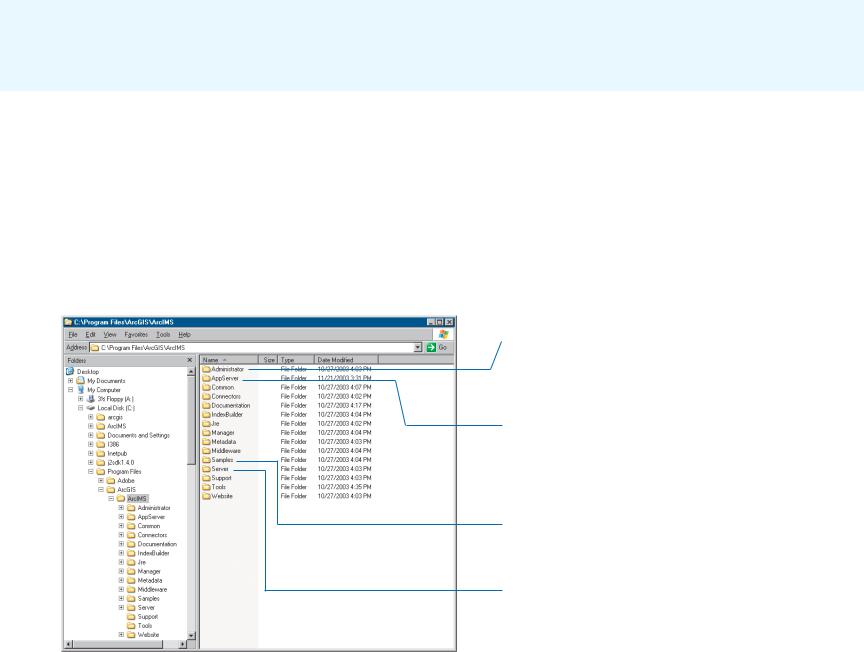
ArcIMS directories and file locations
The two main directories to which ArcIMS installs files by default (for
Windows and UNIX/Linux) are:
•<ArcIMS Installation Directory>/arcims
•The ArcIMS Web site directory. The default installation location and name for this directory is <drive>/arcims.
The following two illustrations show what the top levels of these two directories look like in a Windows environment.
<ArcIMS Installation Directory>/arcims
Stores the esriadmin.properties file in its esriadmin/ WEB-INF subdirectory. You may need to edit this file if you are using Service Administrator.
Stores ArcIMS Application Server files such as AppServerStatus.log, which captures ArcIMS error messages, and AppServer.properties, which stores settings related to performance and response time and Application Server log files used for debugging. It also stores the files for the ArcIMS Tasker.
Stores sample data, configuration files, and applications, including the sample data used in ArcIMS tutorial exercises.
Stores ArcIMS Spatial Server files, such as log files, which capture ArcIMS error and warning messages. It also stores the Spatial Server configuration files, which store settings that primarily affect error messaging, performance, and output limits.
12 |
GETTING STARTED WITH ARCIMS |

ArcIMS Web site directory
The ArcIMS Web site directory stores the following folders:
•AXL—The default location for your configuration file or files (.axl, .mxd, and .pmf files).
•output—The default location for the output images and ZIP files generated by the Spatial Server.
•website—The folder to which sample customized HTML and Java Viewers are installed and the default location of the Web sites (viewers) you create in Designer.
Stores the configuration files for your site.
Stores the output images and ZIP files generated by the Spatial Server.
The location of the Web sites (viewers) you create in Designer and sample customized viewers that come with ArcIMS.
The ArcIMS Web site directory. By default, the name you type in the first panel of Designer as your site directory name is created as a subfolder of this directory.
ABOUT ARCIMS AND THIS GUIDE |
13 |