

Exercise 4: Viewing your Web site
You are ready to access the Web site you just created. This lets you see what your users will see when they access your site.
1.Open a Web browser.
2.Access your Web site by typing its URL in the Address or Location text box as the following syntax shows, then pressing Enter.
The URL must contain http://<your machine name>/ <Website directory>/<Web site name>.
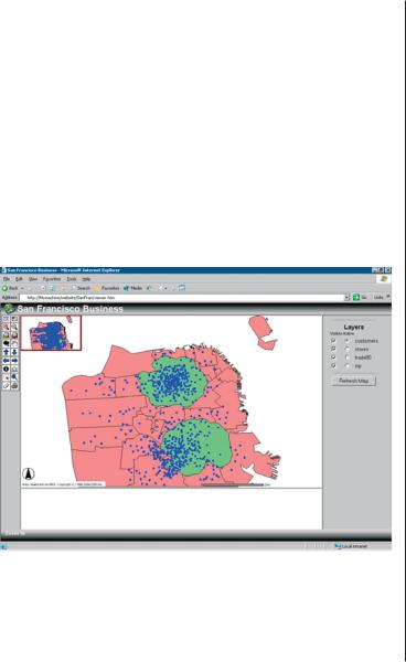
The finished Web site, or Internet GIS application, that results from performing the exercises in this tutorial. This HTML Viewer-based site is being viewed in an Internet Explorer browser on a Windows platform.
3.Verify that your Web site has the look and functionality that you specified by completing the following tasks.
•Compare the tools on the toolbar to the tools you chose when you designed your Web site.
•Use the Pan and Zoom tools to navigate around the map.
•Ensure that the following Graphic Selection tools appear on the toolbar: Select by Rectangle, Select by Line/Polygon. Test each tool by clicking it and using it to graphically select features on the map.
•Click the Identify tool, then click an active layer in the layers list. Next, select a feature from that layer on the map. Verify that the information shown matches the fields you selected for the Identify tool.
•Verify that you have an overview map. Toggle the overview map on and off using the Toggle Overview Map button.
•Toggle between the layer list and legend. By default, the layer list is displayed.
•Check to see that the scalebar is expressed in the units you specified.
•Open Windows Explorer, navigate to the Web site directory, and look at the files created.
Congratulations! You have completed the quick-start tutorial. You are now ready to begin creating Web sites of your own.
QUICK-START TUTORIAL |
45 |
Quick reference |
4 |
|
IN THIS CHAPTER
•Author
•Designer
This chapter provides illustrations and descriptions of each of the major components of ArcIMS and their user interface components, such as toolbars. It also provides illustrations and descriptions of MapNotes and EditNotes.
•Administrator
•Service Administrator
•Viewers
47
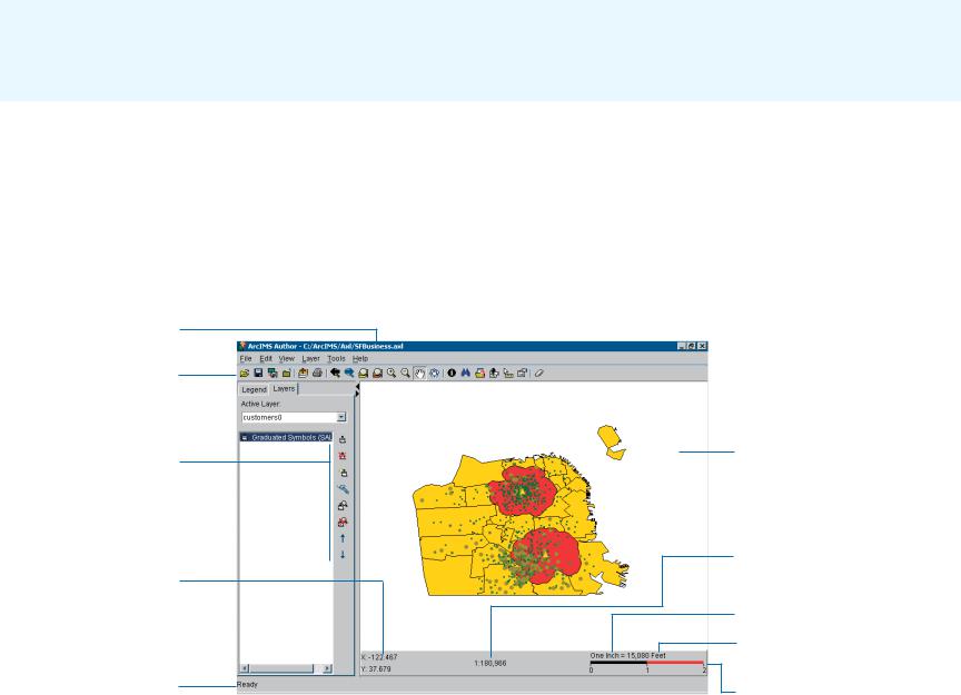
Author
You use ArcIMS Author to create a map for your Web site by performing such tasks as adding data layers, setting layer symbology, and creating stored queries. Author always saves your map content in a configuration file with the .axl file extension.
You can edit this file later using Author, or you can edit it manually. If you change or replace the configuration file, be sure to refresh the service you associated with it. For more information on editing the configuration file, see Chapter 1, ‘About ArcIMS and this guide’ and the ArcIMS Help.
The purpose of the toolbar buttons and elements in Author are to help you, the ArcIMS Web site creator. They help you navigate the map you are creating and help you develop your map content. Be careful not to confuse them with those available in Designer and in the viewers. While some Author toolbar buttons and elements are similar to those available in Designer and the viewers, those in Author have no effect on or relationship to those your users will get in their viewer. You select user buttons and elements in Designer. For example, although Author has a Save .axl button, the HTML Viewer does not.
Name of .axl file you are editing.
Author’s main toolbar.
Author’s Layers
toolbar.
The pointer’s x and y coordinates; updates with every move of the pointer on the map display area.
Status bar. Indicates the task being performed. Ready indicates
Author is ready to
perform the next ArcIMS Author main window with the Layers tab selected. You create your map in Author. command.
The map display area.
Map scale. For this map, any unit of measurement on the screen equals 180,966 of the same units on the earth’s surface.
Screen units are inches.
Distance units are feet.
Scalebar.
48 |
GETTING STARTED WITH ARCIMS |

Author’s main toolbar
|
|
|
|
|
|
|
|
|
|
|
|
|
|
|
|
|
|
|
|
|
|
|
|
|
|
|
|
|
|
|
|
|
|
|
|
|
clicked |
the |
|
|
|
|
|
|
|
|
|
|
|
|
|
|
|
|
|
|
|
|
|
|
|
|
|
one |
|
|
|
|||
|
|
|
|
|
|
|
|
|
|
|
|
|
|
|
|
|
|
|
|
|
|
|
|
|
|
|
|
|
|
|
|
|
|
have |
|
|
|
|
|
|
|
|
|
|
. |
|
|
|
|
|
|
|
|
|
|
|
|
|
|
|
|
|||||||||
|
|
|
|
|
|
|
|
|
|
|
|
|
|
|
|
|
|
|
|
|
|
|
|
|
|
|
|
|
|
|
|
|
|
|
|
|
|
|
|
|
|
|
|
|
|
around |
|
|
|
|
|
|
|
matching |
the |
|
|
|
|
|||||||||||
|
|
|
|
|
|
|
|
|
|
|
|
|
|
|
|
|
|
|
|
|
|
|
|
|
|
|
|
|
|
|
|
|
|
|
|
|
|
|
|
|
|
|
|
|
|
|
|
|
|
|
|
|
|
|
|
|
|
|
|
|
|
|
|
|
||||||
|
|
|
|
|
|
|
|
|
|
|
|
|
|
|
|
|
|
|
|
|
|
|
|
|
|
|
|
|
|
until |
you |
|
|
|
|
|
|
|
. |
|
|
|
|
|
a box |
|
|
|
|
|
|
|
east, |
|
|
|
|
|
|
to |
locate |
|||||||||
|
|
|
|
|
|
|
|
|
|
|
|
|
|
|
|
|
|
|
|
|
|
|
.Unavailable |
|
|
|
|
|
|
|
|
layer |
|
|
drag |
|
|
|
|
south, |
|
value |
|
|
|
|
|
|
|
|
|
|||||||||||||||||||
|
|
|
|
|
|
|
|
|
|
|
|
|
|
|
|
|
|
|
|
|
|
|
|
|
|
the |
|
|
|
|
|
or |
|
|
|
|
|
|
|
|
|
. |
|
|
|
of |
||||||||||||||||||||||||
|
|
|
|
|
|
|
|
|
|
|
|
|
|
|
|
|
|
|
|
|
|
|
|
|
|
|
|
|
|
|
|
|
|
|
|
|
|
|
|
|
|
|
|
|
|
attribute |
|
|
|
|
|
|
|
|
|
|
||||||||||||||
|
|
|
|
|
|
|
|
|
|
|
|
|
|
|
|
|
|
|
|
|
|
|
|
|
|
. |
|
|
|
|
|
|
|
active |
|
|
|
click |
|
|
|
|
|
north, |
|
|
|
|
|
|
|
|
|
|
are |
|
|
|
|
|
||||||||||
|
|
|
|
|
|
|
|
|
|
|
|
|
|
|
|
|
|
|
|
|
|
|
|
button |
|
|
|
|
|
|
|
|
|
|
|
|
|
|
|
|
|
|
— |
|
|
|
|
|
|
|
|
|
|
|
|
|
|
|
|
|
|
|
|
|||||||
|
|
|
|
|
|
|
|
|
|
|
|
|
your |
|
|
|
|
extent |
|
|
|
of |
|
|
|
|
|
area |
you |
|
|
directions |
|
|
|
|
|
an |
|
|
|
|
|
|
|
that |
|
|
|
|
|
|
|
|||||||||||||||||
|
|
|
|
|
|
|
file |
|
.axl file |
|
to |
|
|
|
|
|
|
|
|
|
extent |
|
|
|
|
the |
|
|
|
|
|
with |
|
|
|
|
|
a layer |
specifyproperties |
|
||||||||||||||||||||||||||||||
|
|
|
|
|
|
|
|
|
|
|
|
|
|
|
|
|
|
|
extent |
|
|
|
|
|
|
|
|
|
|
|
|
|
|
|
|
|
|
|
|
|
|
|
|
|
|
|
||||||||||||||||||||||||
|
|
|
|
|
|
|
. |
|
. |
|
|
|
|
|
|
|
|
|
|
|
|
|
|
|
|
|
|
|
|
|
|
|
|
|
|
|
|
|
|
|
|
|
|
|
|
|
|
|
|
|
|
|
|
|
|
|
|
|
|
|
|
|
|
|
|
|
|
|
|
|
|
|
|
|
.axl |
|
|
|
|
your |
map . |
|
|
|
|
|
|
next |
|
|
|
|
|
|
full |
|
|
|
|
|
|
|
|
|
|
|
|
|
of four |
|
|
|
|
features |
. |
|
|
|
fields |
of |
|
users |
display |
|
. |
|
|
|
|||||||||||||
|
|
|
current |
|
|
|
|
current |
|
|
printer |
|
|
|
to |
|
previous |
|
to |
the |
|
|
|
|
|
out |
from |
|
|
|
|
|
one |
|
|
|
|
|
|
|
|
|
|
|
|
your |
|
|
|
|
|
|
|
|
||||||||||||||||
|
|
|
|
|
|
|
|
|
|
|
|
|
|
|
|
|
|
|
|
|
|
|
|
|
|
|
|
|
|
|
|
|
|
type |
|
|
|
|
|
|
|
|
|
layer |
|
|
|
|||||||||||||||||||||||
|
|
|
|
|
|
|
|
|
|
|
|
|
|
|
|
|
the |
|
|
|
|
|
|
|
|
|
|
|
|
|
|
|
|
|
|
|
|
|
|
Find |
you |
|
|
|
|
|
|
|
|
|
|
|
|
|
|
|
|
|
||||||||||||
|
|
|
|
|
|
|
|
|
|
|
|
|
|
|
|
|
|
|
|
|
|
|
|
|
|
|
|
|
|
|
|
|
|
|
|
|
|
|
|
|
|
|
|
|
|
|
|
|
|
|
|
|
|
|
|
|
|
|
|
|
||||||||||
|
|
|
|
|
|
Close |
|
|
|
|
Go |
|
to |
|
|
|
|
|
|
|
|
|
|
|
|
|
|
|
|
|
|
|
|
|
|
in . |
|
|
|
|
|
|
|
the |
|
|
|
|
the |
|
|
|
|
|
|
|
|
|||||||||||||
|
|
Save |
|
|
|
|
|
|
|
|
|
Go |
|
|
|
|
|
Zoom |
|
|
|
|
Zoom |
|
|
|
|
|
|
Pan |
|
|
|
|
|
|
that |
|
|
|
|
Set |
|
|
|
|
Set |
|
active |
|
|
|
|
|
|
|
||||||||||||||
|
|
|
|
|
default |
|
|
|
|
|
|
|
|
|
|
|
|
|
|
|
|
|
|
|
|
|
|
|
|
|
|
|
|
|
|
|
|
|
|
|
||||||||||||||||||||||||||||||
|
|
|
|
|
|
|
|
|
|
|
|
|
|
|
|
|
|
|
|
|
|
|
|
|
|
|
|
|
|
|
|
|
|
|
|
or west |
|
|
|
|
|
|
|
|
|
|
|
|
addresses |
|
|
the |
|
|
|
|
|
|
|
|
|
|||||||||
|
|
|
|
|
|
|
|
|
|
|
|
|
|
|
|
|
|
|
|
|
|
|
|
|
|
|
|
|
|
|
|
|
|
|
|
|
|
|
|
|
|
|
|
|
|
|
|
|
|
|
|
|
|
|
|
|
|
|
|
|
|
|
|
|
|
|
|
|
|
|
. Open |
|
|
axl |
file |
an |
|
|
|
|
. |
|
Save |
|
|
|
|
Add |
|
|
|
|
|
|
|
|
|
navigate |
|
|
||
as |
|
current |
|
|
|
layers |
|
||
a |
JPEG |
|
map |
|
|
|
|
||
existing |
|
|
|
|
to |
||||
|
|
|
image |
fileimage |
data |
||||
|
|
|
|
|
|
|
|||
|
|
|
|
|
|
. |
|
|
|
|
|
|
|
|
|
|
|
|
|
|
|
|
|
|
|
|
|
|
|
|
|
|
|
|
|
|
|
|
|
|
|
|
|
|
|
|
|
|
|
|
|
|
|
|
|
|
|
|
|
|
|
|
|
|
|
|
|
|
|
|
|
|
|
|
|
|
|
|
|
|
|
|
|
|
|
|
|
|
|
|
|
|
|
|
|
|
|
|
|
|
|
|
|
|
|
|
|
|
|
|
|
|
|
|
|
|
|
|
|
|
|
|
|
|
|
|
|
|
|
|
|
|
|
|
|
|
|
|
|
|
|
|
|
|
|
|
|
|
|
|
|
|
|
|
|
|
|
|
|
|
|
|
|
|
|
|
|
|
|
|
|
|
|
|
|
|
|
|
|
|
|
|
|
|
|
Storea |
|
|
|
|
|
|
|
doesMapTips |
|
|
|
|
|
|
|
|
|
|
|
|
|
|
|
|
|
|||||||||||
|
|
|
to |
|
|
Zoom |
|
|
Zoom |
|
|
|
Pan |
|
|
|
|
|
Identify |
|
|
|
|
|
|
|
|
|
|
|
|
|
|
|
|
|
|
|
|
|
Clear |
|
|
|
|
|
||||||||||||||||||||||||
|
|
Go |
|
|
|
|
|
|
|
|
|
|
|
|
|
|
|
|
|
|
|
|
|
|
|
|
|
|
|
|
once |
|
|
|
|
|
|
|
|
|
|
|
|
|
|
|
|
|
|
|
|
|
|
|
|
|
|
|
|
|
|
|
|
|
|
|
||||
|
changed |
the |
|
|
|
to |
the |
|
|
|
in |
|
|
|
|
the |
|
|
|
|
|
|
|
|
|
|
data |
|
own |
|
|
|
not |
|
tool |
|
|
|
selection |
|
|
|
|
|||||||||||||||||||||||||||
|
|
|
|
|
|
|
|
|
|
|
|
|
|
|
|
|
|
|
|
|
|
. |
|
|
|
|
|
|
|
|
|
|
|
|
|
|
|
|
|
|
||||||||||||||||||||||||||||||
|
|
|
|
|
|
|
|
|
|
|
|
|
|
|
to |
|
|
|
|
|
map |
|
tool |
|
|
|
|
|
your |
|
|
|
|
|
|
|
|
|
|
|
|
|
|
|
the |
|
|
|
|
|||||||||||||||||||||
|
|
|
|
|
|
|
|
previous |
|
|
|
full |
|
|
|
|
|
|
the |
|
|
|
|
|
|
|
List |
|
|
map query |
|
|
|
use |
|
|
|
set |
|
|
|
Display |
|
|
|
|
|
. |
current |
|
|
|||||||||||||||||||
|
|
|
|
|
|
|
|
|
|
|
|
|
|
|
|
|
area |
|
|
|
|
|
|
the |
|
|
|
|
|
|
|
|
|
|
|
|
|
|
|
|
|
|
|
|
|
|
|
|
|
|||||||||||||||||||||
current |
|
|
|
|
extents. |
|
|
|
|
extent |
|
|
|
|
|
|
|
|
|
|
|
display |
|
|
|
|
|
|
|
|
|
|
|
|
|
|
|
|
|
|
in |
|
|
|
up |
|
|
|
|
|
|
|
|
|
|
|
|
|||||||||||||
|
|
|
|
|
extent. |
|
|
|
|
|
|
|
|
|
|
that |
|
|
|
|
|
|
|
|
|
|
is |
|
|
that |
|
|
|
|
Author. |
|
|
|
|
|
|
|
|
|
|
|
||||||||||||||||||||||||
for |
|
axl |
|
|
|
|
|
|
|
|
|
|
|
|
|
|
|
|
in |
|
|
|
|
|
|
|
|
|
|
|
|
|
|
|
|
|
|
|
|
|
|
|
|
|
||||||||||||||||||||||||||
|
|
|
|
|
|
|
|
of |
|
|
|
|
|
|
|
|
|
|
|
|
|
|
|
|
|
|
|
|
|
|
|
|
|
|
|
|
|
|
|
|
|
|
|
|
||||||||||||||||||||||||||
|
|
|
|
|
|
|
|
|
|
|
|
|
|
|
|
|
|
|
|
|
|
|
|
|
|
|
|
|
|
|
|
|
|
|
|
|
|
|
|
|
|
|
|
|
|
|
|
|
|
|
|
|
|
|
|
MapTips |
|
|
|
|
|
|
|
|
|
|||||
|
|
. |
|
|
. |
|
|
|
|
|
|
|
|
|
|
|
the |
|
|
|
|
|
|
|
|
|
|
|
|
|
|
|
|
attributes |
|
published be |
|
|
|
|
|
|
feature |
|
|
|
|
|
|
|
||||||||||||||||||||
|
|
|
|
|
|
|
|
|
|
|
|
|
|
|
|
|
|
|
|
|
|
|
|
|
|
|
|
|
|
|
|
|
|
|
|
|
|
for |
|
|
|
|
|
|
|
|
|
|||||||||||||||||||||||
|
inclusion |
|
|
|
|
|
|
|
|
|
|
|
|
|
|
|
|
|
|
|
|
|
|
|
you |
|
|
|
the |
|
|
|
|
|
|
|
of |
|
|
|
|
|
|
|
can |
|
|
|
|
|
|
|
|
|
|
|
|
|
|
|
|
|
|
|
||||||
|
|
|
|
file |
Opensa |
|
|
|
Unavailable |
|
|
|
|
map. |
|
|
click |
|
|
|
direction |
|
|
|
the |
|
|
|
|
|
|
|
|
the |
|
by |
|
|
|
|
attribute |
|
|
|
|
|||||||||||||||||||||||||
|
|
|
|
|
as |
|
|
|
|
|
|
|
|
|
|
or |
|
|
|
|
|
|
|
|
|
|
|
|
|
|
|
|
|
|
|
|
|
|||||||||||||||||||||||||||||||||
|
|
|
|
|
|
|
layersin |
|
|
|
|
|
|
|
|
|
|
|
|
|
|
|
|
|
|
|
drag |
|
|
|
you |
|
|
|
|
feature |
|
|
|
|
run |
|
|
|
|
your |
users |
data. |
|
|
||||||||||||||||||||
|
|
|
|
|
|
|
Catalog |
|
|
|
|
|
until |
|
|
|
|
|
|
|
|
|
|
|
|
|
a |
|
|
|
|
|
|
|
|
|
|
|
|
|
|
your |
|
|
|
|
|
|
||||||||||||||||||||||
|
|
|
|
|
|
|
|
|
|
|
|
|
|
|
|
|
|
|
|
|
|
|
|
|
|
|
|
|
|
|
|
|
|
|
|
|
|
|
|
|
|
|
|
|
|
|
just |
|
|
|
||||||||||||||||||||
|
|
|
|
|
|
|
|
|
|
|
|
|
|
|
|
|
you |
|
|
|
|
|
|
|
|
|
|
|
|
|
|
|
click |
|
|
|
|
|
|
|
|
|
|
|
|
|
|
Internet. |
users |
|
|
|
— |
This |
|
|||||||||||||||
|
|
|
|
|
|
|
|
|
|
|
|
|
|
|
|
|
|
|
|
|
|
|
|
|
|
|
|
|
|
|
|
box |
|
|
|
|
|
|
|
|
|
|
you |
|
|
|
|
|
|
|
||||||||||||||||||||
|
|
|
|
|
|
|
|
|
your |
|
|
|
|
|
|
|
|
|
|
|
|
|
|
|
|
|
|
|
|
|
|
|
|
|
|
|
|
|
|
|
|
|
|
|
|
|
|
|
|
|
|
|
|
|
||||||||||||||||
|
|
|
|
|
|
|
|
|
mapwindow. |
|
|
|
|
|
|
have |
|
|
|
|
|
|
|
|
|
|
|
|
|
and |
drag |
|
|
|
|
|
|
|
|
|
|
|
for |
|
tool |
|||||||||||||||||||||||||
|
|
|
|
|
|
|
|
|
|
|
for |
|
|
|
|
|
|
|
|
|
|
|
|
|
|
|
|
|
|
|
|
around. |
|
|
|
|
|
|
|
|
|
clicked. |
|
|
|
|
|
|
|
|
your |
|||||||||||||||||||
|
|
|
|
|
|
|
|
|
|
|
|
|
|
you |
|
|
|
|
|
|
|
|
|
|
|
|
|
|
|
|
|
|
|
|
|
|
|
|
|
|
|
|
|
the |
|
|
|
|
|
|
|
|
|
|
|
|
||||||||||||||
|
|
|
|
|
|
|
|
|
|
|
|
|
|
|
|
|
|
|
|
|
|
|
|
|
|
|
|
|
|
|
|
|
|
|
|
|
|
|
|
|
|
|
|
|
|
|
|
|
cursor. |
|
|
|
|
|
|
|
|
|
|
|||||||||||
|
|
|
|
|
|
|
|
|
|
|
|
|
|
|
to |
|
|
|
|
|
|
|
|
|
|
|
|
|
|
|
|
|
|
|
|
|
|
|
|
|
|
|
|
|
|
|
|
|
|
|
|
|
|
|
|
|
|
|
|
|||||||||||
|
|
|
|
|
|
|
|
|
|
|
|
|
|
|
|
|
|
|
|
|
|
|
|
|
|
|
|
|
|
|
|
|
|
|
|
|
|
|
|
|
|
|
|
|
|
|
|
|
|
|
|
|
|
|
|
|
|
|
|
|
|
|||||||||
QUICK REFERENCE |
49 |
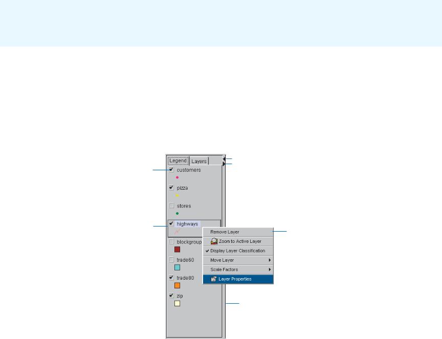
Author’s legend
The legend is a list of layers in the map you are creating. It appears to the left of the map in Author. Beneath each layer’s name, the legend displays the symbology used to represent that layer’s features. The check box to the left of each layer indicates whether or not that layer’s features are visible.
The order in which the layers are listed in the legend is important. The layers at the top draw on top of those below. The layers should be rearranged so that layers forming the background of the map are listed at the bottom. To change the drawing order of a layer, click and drag it to a new position in the legend or
Check the box beside a layer to draw it on the map. Uncheck the box to remove the layer from the map display.
Make a layer active by clicking it in the legend. Many operations only work on active layers. When a layer is active it is outlined in black, giving it a raised appearance.
right-click it, point to Move Layer, and choose one of the options in the list that appears.
You can change the width of the legend by dragging its right border to the left or to the right. You will want to increase the width of the legend to see longer layer names. Use the left and right arrows in the top right corner to maximize and minimize the legend’s width.
Double-click a layer in the legend to open the layer properties dialog box.
 Use the right and left arrows to maximize or minimize the width of the legend.
Right-click a layer to see a list of tools that can be used to change layer properties.
Drag the right border to the left or right to resize the legend.
50 |
GETTING STARTED WITH ARCIMS |
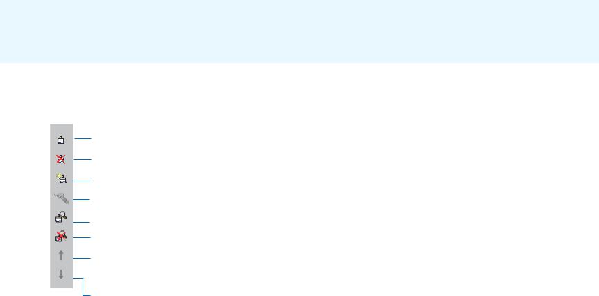
Author’s Layers toolbar
To activate Author’s Layers toolbar, select a layer in Author’s
Legend tab. To view the layer’s toolbar, click the Layers tab.
Edit the selected renderer.
Remove the selected renderer.
Add a renderer.
Clear labels.
Set scale-dependent renderer.
Clear scale-dependent renderer.
Move currently selected renderer in Layers list up a level. Renderers are applied in the order that they appear in the Layers list, starting at the top of the list.
Move currently selected renderer in Layers list down a level.
QUICK REFERENCE |
51 |