

2. Sailing route selection and distance calculation
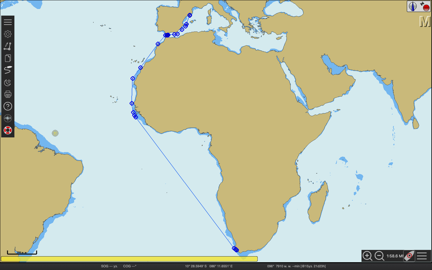
Pic. 2 – Sailing route
Table 2.1 – NAVAREA and NAVTEX
|
№ |
NAVAREA |
NAVTEX |
Country coordinator |
|
1 |
VII |
CAPE TOWN (C) |
SOUTH AFRICA |
|
2 |
II |
TARIFA (G) |
FRANCE |
|
3 |
III |
CABO DE LA NAO (X) |
SPAIN |
According to Load-Line Charts we are allowed to load ship to Summer mark.
Total distance: 5672 nm.
Speed: 10 kn.
Total time: 23 d 15 h 9 m.
3. Departure plan
CAPE TOWN
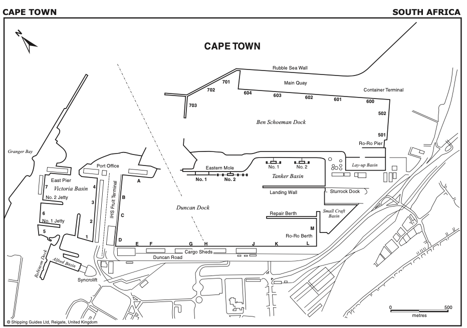
Pic. 3 – Cape Town harbour
Position
Cape Town (33°55′⋅5S, 18°25′⋅7E) is situated in Table Bay.
Function
Cape Town is one of the largest ports in the Southern Hemisphere. The principal exports are fruit, wine, juice concentrates, meat, fish, granite blocks, copper ingots, textiles and industrial goods. Imports include industrial machinery and raw materials.
Cape Town, South Africa’s largest city, with a population of over 3 500 000 is situated around the S part of the bay. The city is dominated by Table Mountain, a national monument and World Heritage site. Cape Town is not only the parliamentary capital of the Republic of South Africa but also the capital of Western Cape Province.
The Castle of Good Hope, which was built by the original Dutch settlers in 1666 in the form of a five-pointed star, exists to this day but is no longer visible from seaward.
Depths
The coast between Milnerton Lighthouse and Ben Schoeman Dock is fronted in places by foul ground upon which the sea breaks heavily after NW and W gales. The SE corner of the bay off Paardeneiland is comparatively shallow having depths of less than 10 m up to 8 cables offshore.
A 12⋅4 m patch, with a 13⋅1 m patch about 2 cables SE of it, lies about 2 miles WNW of Milnerton Light.
A rocky shoal with a least depth of 11⋅2 m over it lies 6 cables ENE of the head of the breakwater. It is marked by No8 Light-buoy (isolated danger) and should be avoided by vessels in bad weather or heavy swells.
Port limits
An area as shown on the chart and bounded by the following limits is under the control of the National Port Authority:
On the W by a line joining Green Point Light and Robben Island Light.
On the N by a line drawn 090° from Robben Island Light to the shore of Table Bay, thence:
S along the HW mark so as to include the foreshore to the castle (33°55′⋅5S, 18°25′⋅7E), thence:
Back to Green Point Light, together with the wharves, jetties, piers, harbour walls and all harbour and dock lands vested in the Government of the Republic of South Africa.
The Victoria and Alfred Basins and New Basin are privately owned and operated but the National Ports Authority retains control over the water areas contained within these basins.
Approach and entry
The bay is approached from N, through W, to SSW, either through the traffic lanes of the TSS, or the inshore traffic zones. The final approach is from W, between Robbeneiland (33°48′⋅4S, 18°22′⋅0E), and Green Point 5miles S, or from N between Robbeneiland and the mainland E. The docks are entered via a short fairway, 2miles ENE of Green Point.
Controlling depths
Least depth in the approach to the port is 15⋅7 m in the entrance channel. Continuous dredging takes place to maintain the charted depths.
Tidal levels
Mean spring range about 1⋅5 m; mean neap range about 0⋅6 m. See information in Admiralty Tide Tables Volume 2.
Density of water
The density of the water is 1⋅025 g/cm.
Local weather
From mid-April to mid-September, N or NW winds generally prevail. They seldom blow strongly from these directions but they often back to W and SW and increase to gale force. The worst weather and heaviest swells are normally experienced after the wind has backed and the swell usually continues for some time after the gale has blown itself out. The heaviest swell comes from WSW or SW giving rise to the notorious “cape rollers” which coming in on the beam make it uncomfortable for ships entering or leaving on either SE or NW courses. Ships at anchor should at all times keep their engines at short notice and be prepared to put to sea on the approach of winter gales. For the rest of the year, particularly during the months of December, January and February, SE winds, which may reach gale force, are to be expected and ships are advised to anchor as far E as their draughts will allow.
Wind strength and direction may vary considerably at different locations in the approaches to Table Bay and
inside the breakwaters. The Port Control can provide wind information on request.
Fog and poor visibility can be expected in the vicinity of Table Bay, the worst months being April to July. The fog is often low lying; at such times Green Point Light becomes obscured while the elevated ground of Signal Hill and Lion’s Head remain clear. A lookout positioned high up may be able to see the masts of other vessels.
Arrival information
Port operations
Oil tankers and vessels carrying hazardous cargo or explosives are prohibited from berthing at night.