


MNPSA 9
Introduction
Due to economic, geographical and geophysical considerations, the airspace over the North Atlantic Ocean between the latitudes of 35N and 70N is some of the most frequently flown airspace in the World. Typically there could be up to 300 aircraft over the Ocean at the same time. More than 425 000 commercial aircraft alone cross the airspace annually. This may seem excessive, but consider that we, flying scheduled passenger operations, share the sky with airfreight operators, the military and long range general aviation aircraft. Whilst the airspace is vast (some 6 million square miles) and the possibility of one aircraft even seeing another would appear remote, the actual situation is dramatically different. By agreement between the states bordering the North Atlantic (Canada; USA; Iceland; Greenland; Norway; the UK; Eire; France; Spain; Portugal) the ICAO North Atlantic Region (NAT region) has been established to provide a framework for the solution of problems concerned with transoceanic operations. Within the NAT region, the area over the ocean and northwards towards the North Pole is designated as airspace in which a minimum standard for air navigation has been specified. This is known as the NAT Minimum Navigation Performance Specification Airspace (MNPSA). ICAO publishes two documents concerned with the NAT region: Doc 7030 contains the NAT Regional Supplements, and the North Atlantic MNPS Airspace OM covering specific NAT procedures.
Considerations
The problems are threefold: Firstly, the economic requirement is for traffic to fly to and from North America, mainly the United States and Canada, and Europe. The majority of this traffic is scheduled passenger operations and this falls into distinct flow patterns resulting in a tidal type of situation with peaks in each direction at certain times of the day. Secondly, the meteorological situation over the Ocean ‘standardizes’ the polar frontal jet stream and the sub-tropical jet stream at about 55°N and 40°N respectively. The jet stream flow is always from west to east. Whilst it is not always desirable to fly in a jet stream it is always desirable to avoid a jet stream when flying in the opposite direction. Modern turbine powered aeroplanes are most efficient (fuel efficient) at the altitude where the air is coldest (densest) for engine performance, but least dense for drag reduction. The air is coldest at the tropopause but whilst the air above the tropopause is less dense, the temperature remains constant and therefore there is little advantage to be gained by climbing above the tropopause. Hence, all the traffic flying across the North Atlantic will want to cruise at or about the tropopause. At 40°N this will be about 40 000 ft whereas at 55°N this will be about 35 000 ft. This tends to concentrate all the traffic at or about these altitudes. Finally, the total absence of ground based navigation aids means that navigation accuracy will not be as good as over land and allowances in separation will need to be made by the ATC authorities.
References
1.ICAO North Atlantic Manual.
2.ICAO Regional Air Navigation (RAN) Plan for the NAT Region.
3.ICAO Regional Supplementary Procedures (Doc 7030).
Transoceanic Navigation Problems
The problems of navigating aeroplanes over vast areas of sea are really no worse than the problems of doing the same over huge tracts of uninhabited land e.g. the Sahara Desert. These are:
MNPSA 9
119

9 MNPSA
MNPSA 9
•No aerodromes.
•No ground based radar.
•No fixed radio navigation beacons (VOR; NDB etc.).
•Outside of VHF radio range hence reliance on HF communications.
Additionally, the North Atlantic suffers from abnormally high levels of traffic density with modern turbine engined aeroplanes wanting to fly at the same flight levels, and an economically generated tidal flow of traffic. As the NAT region encompasses latitudes higher than 70N problems are encountered with magnetic compasses due to the weak horizontal component of the Earth’s magnetic field (less than 6 μTesla) and occasionally large values of magnetic variation (31°W at Resolute Bay in northern Canada). This last problem requires radio navigation beacons to be oriented to true north and at polar latitudes the use of grid navigation techniques using gyro referenced compasses.
The Airspace
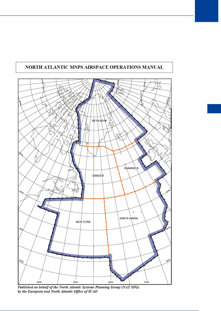
The concentration of the traffic by route and altitude, together with the separation requirements and navigation system requirements, mean that all traffic flying across the North Atlantic is required to fly IFR. To this extent, all the airspace is classified as class A between FL55 and FL660. By definition, class A is controlled airspace (CAS) in which ATC is provided to IFR traffic therefore the airspace must, by definition, be a control area (CTA). Indeed this is the case but because special rules are applicable, the airspace is defined as an Oceanic Control Area (OCA). In practice, there are 5 NAT OCAs encompassing the MNPSA (Shanwick; Santa Maria; Gander; New York; Reykjavik) with 5 corresponding Oceanic Area Control Centres (OACCs) at Prestwick; Lisbon; Gander; New York and Reykjavik respectively. The OCAs are contiguous with the East/West boundary being at 30W (Shanwick and Gander) and 40W (Santa Maria and New York) and the North/South boundary being at 45N (Shanwick/Gander and Santa Maria/New York). Reykjavik extends from the northern boundaries of Shanwick and Gander to the North Pole, including the majority of Greenland. The easterly and westerly continental boundaries are defined by domestic airspace (national FIRs) although beyond the SW boundary of New York North Atlantic Oceanic Airspace is still New York OCA, but not part of the NAT MNPSA. This area is known as the West Atlantic Route System (WATRS) and contains routings for traffic between USA and the Caribbean. The Easterly boundary of Reykjavik is the western boundary of the Bodø (pronounced Boo der) OCA. Bodø is in Norway and the OCA is not part of the MNPSA area.
MNPS Authority
Operators of aircraft flying within the MNPSA are required to have authority approval (stated on the AOC) requiring the aircraft to be able to navigate in accordance with the relevant RNP. Approval for MNPS will be indicated to Air Traffic by inserting the letters SX in item 10 of the flight plan.
Practical experience has shown that when two or more turbojet aircraft, operating along the same route at the same flight level, maintain the same Mach number, they are more likely to maintain a constant time interval between each other than when using other methods. This is due to the fact that the aircraft concerned are normally subject to approximately the same wind and air temperature conditions, and minor variations in ground speed, which might increase and decrease the spacing between them, tend to be neutralized over long periods of flight. Requested TRUE Mach number, taking into account known errors in the flight deck indication, is to be inserted in item 15 of the flight plan. Wherever possible this requested speed will be accommodated, however occasionally ATC may need to assign a Mach number
120
MNPSA 9
0.01 higher than, or 0.02 lower than requested. Pilots should maintain their last assigned Mach number during step-climbs in oceanic airspace. If due to aircraft performance this is not feasible ATC should be advised at the time of the request for the step climb. After leaving oceanic airspace pilots must maintain their assigned Mach number in domestic controlled airspace unless and until the appropriate ATC unit authorizes a change.
MNPSA 9
Figure 9.1: NAT airspace
121

MNPSA 9
9 MNPSA
RVSM
MNPS Airspace extends from Flight Level (FL) 285-420, incorporating the RVSM FLs 290-410. Aircraft flying in MNPSA must also be authorized to fly RVSM, and must comply with the altimetry Minimum Aircraft System Performance Specification (MASPS). In domestic airspace RVSM FLs are allocated according to magnetic track (i.e. flights Easterly are on odd FL, 290, 310 etc, Westerly on even FL 300, 320 etc.) Due to the tidal nature of the majority of North Atlantic traffic during the times of the Organized Track System (OTS) all FL are available in both directions. Outside the OTS standard RVSM FL apply. The minimum equipment requirement for RVSM flight is as follows;
•Two independent barometric altimeters agreeing to within +/- 200 ft
•Autopilot with height hold capability
•Altitude deviation alerting system (minimum of an aural alert if the aircraft deviates by +/-
300 ft)
•SSR with altitude alerting mode (mode C)
•The altimeters must be checked prior to entering the NAT OCA. Pilots must report when reaching any new cruising level, and if a deviation of more than 300 ft occurs it must be reported to ATS, with a subsequent written report post flight.
Navigation System Requirements
The minimum equipment for flight in MNPS Airspace is 2 independent Long Range Navigation Systems (LRNS) to cater for failure of one system. Approved systems may be:
•GNSS (GPS)
•INS
•IRS
Each system must be capable of providing continuous position, track and speed information.
In addition, all turbine powered aeroplanes with MTOM > 5700 kg, or having more than 19 passenger seats are required to carry and operate ACAS II in the NAT region. (However this equipment is required in the relevant aircraft of all EU operators anyway)
Navigation System Serviceability
The requirement for 2 LRNS covers the case of a failure in one system and each system must have a failure warning indication. Where triple INs are used as an IRS, a ‘voting’ system is employed to ensure use of the most accurate information. In a double INS system, external information (heading and drift) will be required to determine which system is inaccurate if a failure occurs. In the event of total failure, ask another aircraft for assistance or follow the contrails. In the event of total navigation system failure, declare an emergency using MAYDAY or PAN PAN procedures. Navigation system failure procedures are covered at the end of this chapter.
122