

ppl_04_e2
.pdfID: 3658 |
|
Customer: Oleg Ostapenko E-mail: ostapenko2002@yahoo.com |
|
Customer: Oleg Ostapenko E-mail: ostapenko2002@yahoo.com C H A P T ER |
2 4 : A T IS |
R e p r e s e n t a t i v e P P L - t y p e q u e s t i o n s t o t k n o w l e d g e o f A T IS .
1.When are ATIS broadcasts updated?
a.Any time the aerodrome or weather information changes
b.Only when the aerodrome information changes
c.Every 30 minutes
d.Every hour
2.To minimise VHF frequency use, the ATIS can be broadcast on the voice frequency of which navigation aid?
a.ILS
b.NDB
c.VOR
d.GPS
3.In an ATIS broadcast, what is used to identify the current report?
a.An alphabetical code
b.A number
c.A validity number
d.An issue time
4.What is the ATIS?
a.A chart of current aerodrome and weather information
b.A continuous broadcast of current aerodrome and weather information
c.A continuous broadcast of weather information
d.A printed text report of current aerodrome and weather information
5.In what frequency band is the ATIS normally broadcast?
a.LF
b.HF
c.ADF
d.VHF
Question |
1 |
2 |
3 |
4 |
5 |
|
|
|
|
|
|
Answer |
|
|
|
|
|
T h e a n s w e r s t o t h e s e q u e s t i o n s c a n b e f o u n d
297
Customer: Oleg Ostapenko E-mail: ostapenko2002@yahoo.com
298
Customer: Oleg Ostapenko E-mail: ostapenko2002@yahoo.com
CHAPTER 25
WINDSHEAR
299

Order: 6026
Customer: Oleg Ostapenko E-mail: ostapenko2002@yahoo.com
Customer: Oleg Ostapenko E-mail: ostapenko2002@yahoo.com
C H A P T ER 2 5 : W INDS H EA R
300
ID: 3658
Customer: Oleg Ostapenko E-mail: ostapenko2002@yahoo.com Customer: Oleg Ostapenko E-mail: ostapenko2002@yahoo.com
C H A P T ER 2 5 : W IN
WINDSHEAR.
Low altitude windshear is a major hazard to light aircraft. The effects of windshear in the take-off, approach and landing phases of flight have been responsible for numerous accidents to light aircraft.
The aim of this chapter is that the pilot should learn the definitions of windshear, where and when to expect windshear, and what actions should be taken to avoid or counter windshear.
DEFINITIONS.
Windshear may be defined as variations in wind speed and/or direction along an aircraft’s flight path which may displace an aircraft abruptly from its flight path and which may require substantial control inputs to counter it.
Low Altitude Windshear is defined as windshear on the final approach path or along the runway, and on the take-off and initial climb-out flight paths.
Windshear is defined as a change in
wind speed and/or direction over a relatively short distance.
Figure 25.1 Vertical Windshear. |
Figure 25.2 Horizontal Windshear. |
Vertical Windshear is defined as a change of wind speed and/or direction with height.
(See Figure 25.1.)
Horizontal Windshear is a change of wind speed and/or direction over a horizontal distance. (See Figure 25.2.)
THE EFFECTS OF WINDSHEAR.
The effect of an aircraft flying into windshear is basically that the aircraft’s indicated airspeed will either decrease or increase, momentarily. Because the lift generated by an aircraft’s wings is heavily dependent on its airspeed, the effect of windshear is also to increase or decrease lift sharply.
An aircraft in flight, because it possesses mass and is flying at a given speed, will also possess a certain amount of momentum by virtue of its mass and speed. (momentum = mass × velocity). Because of the associated property of inertia, an aircraft flying at a given velocity will, therefore, tend to continue flying at that velocity, even when a force intervenes to change its velocity. In other words, it will always take a finite amount of time for an aircraft to change speed.
Whenever an aircraft flies into or through
windshear, its
airspeed will be affected. This is especially hazardous on take-off and landing.
301
Order: 6026
Customer: Oleg Ostapenko E-mail: ostapenko2002@yahoo.com
Customer: Oleg Ostapenko E-mail: ostapenko2002@yahoo.com
C H A P T ER 2 5 : W INDS H EA R
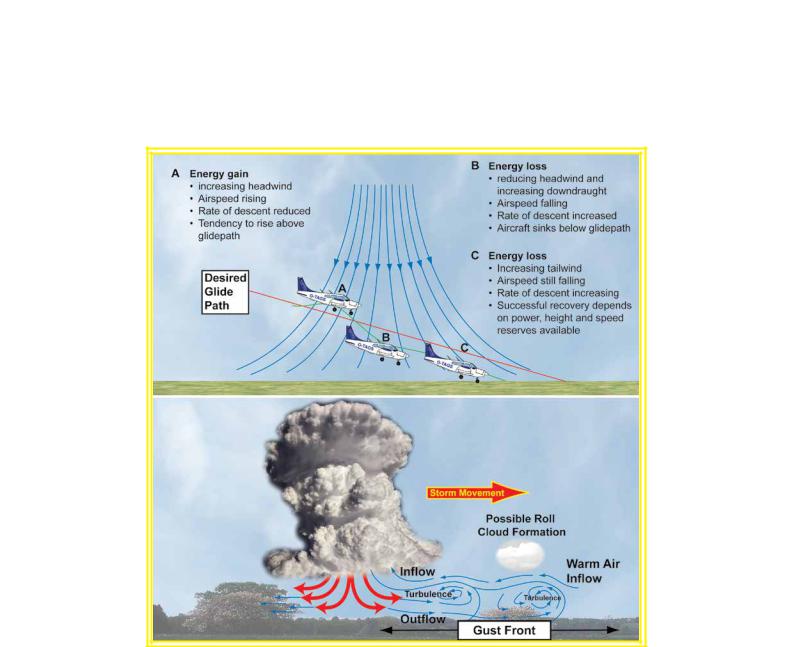
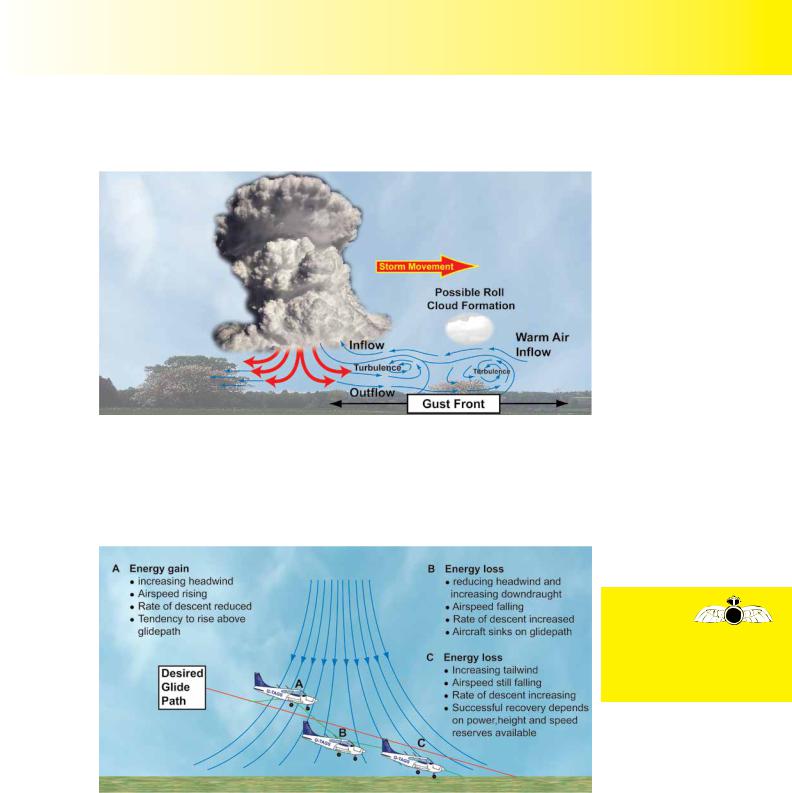
When vertical
windshear is present on the approach,
the pilot must take care not to let his airspeed decay, or the aircraft may lose height faster than planned, and undershoot the desired touch-down point.
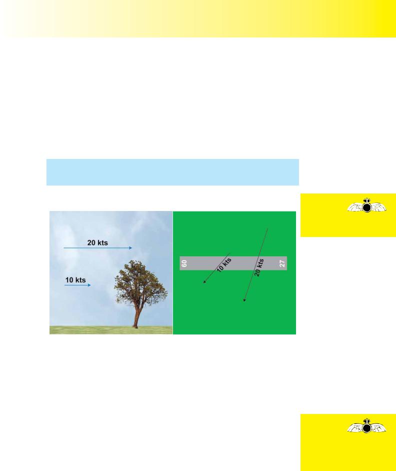
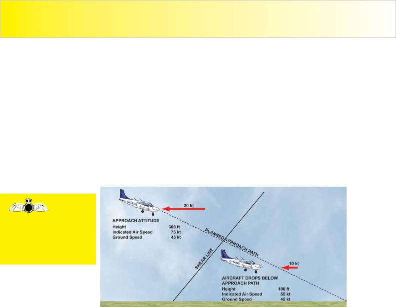
So, if an aircraft is approaching to land at an indicated airspeed of 75 knots against a 30 knot headwind, its speed over the ground will be 45 knots. But, if vertical windshear is present on the approach, and the windspeed suddenly drops to 10 knots (see Figure 25.3), the aircraft will be descending through decelerating air, and the aircraft’s momentum will cause it to continue, momentarily, to travel at 45 knots relative to the ground. Consequently, for a very short period of time, the aircraft’s airspeed will fall to 55 knots. More importantly, however, the lift generated by the aircraft’s wings will suddenly decrease, too, and the aircraft will sink below the pilot’s desired approach path. (Remember that the lift force acting on the aircraft varies with the square of the windspeed: Lift = ½rCLV²S) If the pilot is unprepared for this situation, height loss can be significant.
If the aircraft is close to the ground, a heavy landing or undershoot, or both, can occur. In extreme cases, such a situation may lead to a serious impact with the ground.
Figure 25.3 Vertical windshear on the approach and its possible effect on an aircraft approaching to land.
The pilot must, therefore, always be aware of weather and wind conditions which may give rise to windshear. He must also know the symptoms of windshear, and how to react to the effects of windshear if he has been unsuccessful in avoiding it.
The main problem facing a pilot whose aircraft encounters low-level windshear is the very fact that he may be low with little height in which to recover, if things go badly wrong. And, of course, the average light aircraft does not have a lot of power to counter the effects of windshear. Consequently, it is of supreme importance that airspeed be constantly monitored, and not allowed to decay.
Let us now look at some of the causes of windshear:-
CAUSES OF WINDSHEAR.
T h u n d e r s t o r m s .
Cumulonimbus thunderclouds can create conditions which will produce windshear, because of severe turbulence and precipitation associated with such clouds.
T h e G u s t F r o n t .
Some cumulonimbus thunder clouds have a well-defined area of cold air flowing out from downdraughts, which are called gust fronts, and which extend up to 15 nautical
302
ID: 3658
Customer: Oleg Ostapenko E-mail: ostapenko2002@yahoo.com Customer: Oleg Ostapenko E-mail: ostapenko2002@yahoo.com
C H A P T ER 2 5 : W IN
miles ahead of an approaching storm. These gust fronts are regions of great turbulence which give little or no warning of their approach. (See Figure 25.4.)
Figure 25.4 A gust front associated with a cumulonimbus thundercloud.
M i c r o b u r s t .
A microburst is a highly concentrated and powerful downdraught of air, typically less than 2 nautical miles across, which lasts for about 1 to 5 minutes. Microbursts are the most lethal form of windshear with downdraught speeds of 60 knots or more. There have been a number of fatal accidents to large commercial aircraft caused by microbursts on the final approach.
If a pilot
is caught unawares
by severe
windshear on the approach, an unplanned impact with the ground may result.
Figure 25.5 Windshear on the approach caused by a microburst.
Figure 25.5 depicts how a light aircraft on approach to land, caught in the windshear from a microburst, may be forced below the planned glide-path, because of the effects of windshear on airspeed and rate of descent.
F r o n t a l P a s s a g e .
Fronts vary in strength. It is, normally, only well-developed, active fronts, with narrow frontal zones and marked temperature differences, which are likely to carry the risk of windshear.
303

Order: 6026
Customer: Oleg Ostapenko E-mail: ostapenko2002@yahoo.com
Customer: Oleg Ostapenko E-mail: ostapenko2002@yahoo.com
C H A P T ER 2 5 : W INDS H EA R
On a weather chart, a pilot should look for fronts with sharp changes in wind direction across the front. The pilot should also note that temperature differences of 5°C or more across a front, or a front moving with a speed of 30 knots or more, may indicate a potential windshear hazard.
In v e r s i o n .
A low-level temperature inversion may develop and separate the stronger upper airflow from slower moving air near the surface, giving rise to windshear at the inversion boundary. These inversions tend to form on clear nights.
L o w - L e v e l T u r b u l e n c e .
Low-level turbulence within the friction layer can lead to windshear because of:
•Strong surface winds leading to pronounced gusts and lulls.
•Thermal turbulence caused by intense solar heating.
T o p o g r a p h i c a l W i n d s h e a r .
Topographical windshear is of two principal types. It may be caused by friction between the lower wind and the ground, leading to a marked decrease in wind speed as the surface is approached through the lower 1 000 feet, or so. (See Figure 25.3.) Topographical windshear is also caused by natural or man-made features, such as hills or buildings, which change the direction and speed of the wind blowing over them. Larger airport buildings adjacent to runways, as well as lines of trees, can create local windshear during both the final approach and initial departure.
TECHNIQUES TO COUNTERACT EFFECTS OF WINDSHEAR.
For the pilot of a light aircraft, the best way to deal with windshear is to use his knowledge and understanding of the subject to avoid severe windshear altogether, if at all possible, and consider diverting to an alternate aerodrome. However, should a pilot encounter windshear, the following actions may be considered. (N.B. This is
not a flying instructional manual, and you must, above all, deal with w i n d sinhthe a r manner recommended by your flying instructor.)
•Increase power (to full power, if needed).
•Maintain or increase airspeed appropriately (attitude control).
•Co-ordinate pitch and power correctly.
•Be prepared to carry out a go-around or missed approach.
•If the pilot is on the ground, he should stay there until the windshear has abated.
In order to counteract windshear effect, be prepared to make pronounced control inputs.
If you wish to learn more about low-level windshear, the United Kingdom CAA currently produces an Aviation Information Circular on the subject, AIC Number 19/2002 (pink 28).
304

ID: 3658
Customer: Oleg Ostapenko E-mail: ostapenko2002@yahoo.com
Customer: Oleg Ostapenko E-mail: ostapenko2002@yahoo.com
M ET EO R O L O G Y S Y
JAR-FCL PPL THEORETICAL KNOWLEDGE SYLLABUS
METEOROLOGY
The table below contains the principal topics and subtopics from the current outline syllabus for the theoretical knowledge examination in Meteorology for the Private Pilot’s Licence, as published in JAR-FCL 1. Syllabuses may be modified, so always check the latest examination documentation from your national civil aviation
authority, or from JAR-FCL/EASA.
|
METEOROLOGY |
|
|
|
|
The atmosphere: |
composition and structure; vertical divisions. |
|
|
|
|
|
barometric pressure, isobars; changes of pressure, |
|
Pressure, density and |
density and temperature with altitude; altimetry |
|
terminology; solar and terrestrial energy radiation, |
||
temperature: |
temperature; diurnal variation of temperature; |
|
|
adiabatic process; temperature lapse rate; stability |
|
|
and instability; effects of radiation, advection |
|
|
subsidence and convergence. |
|
|
|
|
Humidity and |
water vapour in the atmosphere; vapour pressure; |
|
dew point and relative humidity; condensation and |
||
precipitation: |
||
vaporisation; precipitation. |
||
|
||
|
|
|
|
high and low pressure areas; motion of the atmosphere, |
|
|
pressure gradient; vertical and horizontal motion, |
|
Pressure and wind: |
convergence, divergence; surface and geostrophic |
|
wind; effect of wind gradient and windshear on take-off |
||
|
and landing; relationship between isobars and wind, |
|
|
Buys Ballot’s law; turbulence and gustiness; local |
|
|
winds, föhn, land and sea breezes. |
|
|
|
|
Cloud formation: |
cooling by advection, radiation and adiabatic expansion; |
|
cloud types (convection clouds; orographic clouds; |
||
|
stratiform and cumulus clouds); flying conditions in |
|
|
each cloud type. |
|
|
|
|
|
radiation, advection, frontal, freezing fog; formation |
|
Fog, mist and haze: |
and dispersal; reduction of visibility due to mist, snow, |
|
smoke, dust and sand; assessment of probability of |
||
|
reduced visibility; hazards in flight due to low visibility, |
|
|
horizontal and vertical visibility. |
|
|
|
|
|
description of and factors affecting the properties |
|
|
of airmasses; classification of airmasses, region |
|
Air masses: |
of origin; modification of airmasses during their |
|
movement; development of low and high pressure |
||
|
systems; weather associated with pressure |
|
|
systems. |
|
|
|
305

Order: 6026
Customer: Oleg Ostapenko E-mail: ostapenko2002@yahoo.com
Customer: Oleg Ostapenko E-mail: ostapenko2002@yahoo.com
M ET EO R O L O G Y S Y L L A B U S
|
|
formation of cold and warm fronts; boundaries between |
|||||||
|
|
airmasses; development of a warm front; associated |
|||||||
Frontology: |
|
clouds and weather; weather in the warm sector; |
|||||||
|
development of a cold front; associated clouds and |
||||||||
|
|
weather; occlusions; associated clouds and weather; |
|||||||
|
|
stationary fronts; associated clouds and weather. |
|||||||
|
|
|
|||||||
|
|
conditions conducive to ice formation; effects of hoar |
|||||||
Ice accretion: |
|
frost, rime ice, clear ice; effects of icing on aeroplane |
|||||||
|
performance; |
precautions |
against |
and |
avoidance |
||||
|
|
of icing conditions; powerplant icing; precautions, |
|||||||
|
|
prevention and clearance of induction and carburettor |
|||||||
|
|
icing. |
|
|
|
|
|
|
|
|
|
|
|||||||
|
|
formation – airmass, frontal, orographic; conditions |
|||||||
Thunderstorms: |
|
required; development process; recognition of |
|||||||
|
favourable conditions for formation; hazards for |
||||||||
|
|
aeroplanes; effects of lightning and severe turbulence; |
|||||||
|
|
avoidance of flight in the vicinity of thunderstorms. |
|||||||
|
|
|
|
|
|
|
|||
Flight over |
|
Hazards; |
influence |
of terrain |
on |
atmospheric |
|||
|
processes; |
mountain |
waves, windshear, |
turbulence, |
|||||
mountainous areas: |
|
||||||||
|
vertical movement, rotor effects, valley winds. |
||||||||
|
|
||||||||
|
|
|
|||||||
Climatology: |
|
general seasonal circulation in the troposphere over |
|||||||
|
Europe; local seasonal weather and winds. |
|
|||||||
|
|
|
|||||||
|
|
|
|||||||
|
|
operational aspects of pressure settings; pressure |
|||||||
Altimetry: |
|
altitude, density altitude; height, altitude, flight level; |
|||||||
|
ICAO standard atmosphere; QNH, QFE, standard |
||||||||
|
|
setting; transition altitude, layer and level. |
|
|
|||||
|
|
|
|
|
|
||||
The meteorological |
|
aerodrome |
meteorological |
offices; |
aeronautical |
||||
|
meteorological |
stations; |
forecasting |
service; |
|||||
organisation: |
|
meteorological services at aerodromes; availability of |
|||||||
|
|
periodic weather forecasts. |
|
|
|
|
|||
|
|
|
|||||||
Weather analysis and |
|
weather charts, symbols, signs; significant weather |
|||||||
forecasting: |
|
charts; prognostic charts for general aviation. |
|||||||
|
|
|
|||||||
|
|
reports and forecasts for departure, en-route, |
|||||||
Weather information |
|
destination |
and alternate(s); interpretation |
of coded |
|||||
|
information |
METAR, |
TAF, |
GAFOR*; availability of |
|||||
for flight planning: |
|
||||||||
|
ground reports for surface wind, windshear, visibility. |
||||||||
|
|
||||||||
|
|
|
|
|
|
|
|
|
|
Meteorological |
|
VOLMET, ATIS, SIGMET. |
|
|
|
|
|||
broadcasts for |
|
|
|
|
|
||||
|
|
|
|
|
|
|
|
|
|
aviation: |
|
|
|
|
|
|
|
|
|
*G A F OmeansR G e n |
e r a l A |
v i a. IntEurope,in GFAo FrisOe usedcR a primarilys t |
|||||||
in Germany and Switzerland.
306