

ppl_04_e2
.pdfID: 3658
Customer: Oleg Ostapenko E-mail: ostapenko2002@yahoo.com
Customer: Oleg Ostapenko E-mail: ostapenko2002@yahoo.com
C H A P T ER 1 5 : A IR M A S S ES A ND
13.Which of the following frontal systems is most likely to produce thunderstorms?
a.A quasi-stationary front
b.A warm front
c.A ridge of high pressure
d.A cold front
14.What would be the change in weather of a typical warm front?
a.Pressure falls, 8 oktas of cloud with a lowering base, and poor visibility
b.Pressure increases steadily, no more then 4 oktas of cloud and good visibility
c.Pressure stops falling, 4 oktas of cloud with a very low base and rapidly improving visibility
d.Pressure falls, 8 oktas of cloud with a lowering base and improving visibility
15.Tropical maritime air coming from the Azores gives what kind of weather?
a.Moist unstable conditions leading to well developed cumulonimbus
b.Moist but stable conditions due to the general subsidence caused by cooling from below, giving low stratus and poor visibility
c.Dry stable conditions leading to good visibility at low level
d.Moist but stable conditions due to the ascent of air caused by being warmed from below, giving low stratus and poor visibility
16.What features characterise an air mass?
a.A mass of air of constant temperature, pressure and humidity, overlying a localised hotspot on the Earth’s surface
b.A mass of air displaced from an anticyclone to a depression, as a frontal wind
c.A mass of air, of large horizontal extent, possessing fairly uniform horizontal values of temperature, pressure and humidity drawn from the cyclonic weather of which it is part
d.A mass of air, of large horizontal extent, displays fairly uniform horizontal values of temperature, pressure and humidity, drawn from the anticyclonic region over which it lies
Question |
1 |
2 |
3 |
4 |
5 |
6 |
7 |
8 |
9 |
10 |
11 |
12 |
|
|
|
|
|
|
|
|
|
|
|
|
|
|
|
Answer |
|
|
|
|
|
|
|
|
|
|
|
|
|
|
|
|
|
|
|
|
|
|
|
|
|
|
|
Question |
13 |
14 |
15 |
16 |
|
|
|
|
|
|
|
|
|
|
|
|
|
|
|
|
|
|
|
|
|
|
|
Answer |
|
|
|
|
|
|
|
|
|
|
|
|
|
T h e a n s w e r s t o t h e s e q u e s t i o n s c a n b e f o u n d
217
Customer: Oleg Ostapenko E-mail: ostapenko2002@yahoo.com
218
Customer: Oleg Ostapenko E-mail: ostapenko2002@yahoo.com
CHAPTER 16
THE METAR
219

Order: 6026
Customer: Oleg Ostapenko E-mail: ostapenko2002@yahoo.com
Customer: Oleg Ostapenko E-mail: ostapenko2002@yahoo.com
C H A P T ER 1 6 : T H E M ET A R
220

ID: 3658
Customer: Oleg Ostapenko E-mail: ostapenko2002@yahoo.com Customer: Oleg Ostapenko E-mail: ostapenko2002@yahoo.com
C H A P T ER 1 6 : T H
INTRODUCTION.
The letters METAR stand for METeorological Aerodrome Report. METARs contain coded messages pertaining to the actual weather conditions at a given aerodrome, at a stated time. Figure 16.1 illustrates typical METARs for United Kingdom aerodromes, extracted from the United Kingdom Met Office website.
Figure 16.1 Typical METARs for United Kingdom aerodromes as displayed on the UK Met Office website.
METARs are usually issued every half hour during aerodrome operating hours. The aim of this chapter is to explain the METAR coding, group by group.
DECODING THE METAR.
A METAR is a Meteorological Aerodrome
Report for a
given aerodrome at a stated time.
METARs
are issued every half
hour, during
aerodrome operating hours.
R e p o r t T y p e , A e r o d r o m e a n d Da t e - T i m e G r o u p
Figure 16.2 reproduces the first eight code-groups normally found in a METAR. The first code, (a), is the identification of the type of report; in this case a METAR. The four-letter ICAO designator of the issuing aerodrome is shown next, (b); this example is for Oxford/Kidlington, EGTK.
METAR EGTK 231020Z 260 12 G 25KT 220 V 300
(a) |
(b) |
(c) |
(d) (e) (f) (g) |
(h) |
Figure 16.2 The initial codes of a METAR. Report type (a), ICAO designator (b), Date and time group (c): Observed on 23rd at 1020Z. Wind information (d): 260º True, 12 knots (e) gusting
(f) 25 knots (g). Wind direction variable between 220º and 300º True (h).
The third group, (c), is the date/time group, which simply gives the time of the actual weather observation. The first two digits represent the day of the month, followed by the time in hours and minutes. Time is always given as Coordinated Universal Time (UTC)*, which is, for all practical purposes, the same as Greenwich Mean Time (GMT): the local time at Greenwich, London. In the METAR itself, UTC is indicated by the code Z, pronounced “Zulu”.
W i n d In f o r m a t i o n .
The next item in the METAR (d, e ,f and g) is the observed wind information. Firstly, the direction of the wind given in degrees true, rounded up or down to the nearest 10 degrees, (d), and then the wind speed in knots, (e), which is a mean speed taken over a 10 minute period. However, if a gust is observed which is at least 10 knots more than the mean wind speed, then a gust figure, (g), comes after the mean wind; this gust figure is preceded by the letter G, (f).
* Do not be confused by the abbreviation used for C o o r d i n |
a |
t e d .UDifferenti v e r s a |
l T i m e |
languages have different words to describe any given concept. U T areC |
the letters that have |
|
|
been internationally agreed to stand for what, in English, is called C |
o o r d i n a t e d U |
n i v e r s a l |
|
T i m e . |
|
|
|
221 |
|
|
|

Order: 6026
Customer: Oleg Ostapenko E-mail: ostapenko2002@yahoo.com
Customer: Oleg Ostapenko E-mail: ostapenko2002@yahoo.com
C H A P T ER 1 6 : T H E M ET A R
The next code-group, (h), may or may not appear depending on the directional variability of the wind. Variability is shown after the main wind group and signifies the extremes in the direction of the wind during the previous 10 minutes. The letter V will appear between these two extremes. If there is no wind, the coding, 00000KT, will be used.
V i s i b i l i t y .
Visibility in the METAR is represented by the next group, depicted in red in Figure 16.3. In the METAR, the reported visibility is the prevailing visibility and, may, under certain conditions, include the minimum visibility. Here, the prevailing visibility is reported as 1 400 metres.
Prevailing visibility is the visibility value which is either reached, or exceeded, around at least half the horizon circle, or within at least half of the surface of the aerodrome. If the visibility in one direction, which is not the prevailing visibility, is less than 1 500 m, or less than 50% of the prevailing visibility, the lowest visibility observed, and its general direction, should also be reported.
Up to 10 km, the visibility is measured in metres. For example, 6000 means that the prevailing visibility is 6 000 metres. Once the visibility reaches 10 km or more, the code figure used is 9999.
Visibility of less than 50 metres is indicated by the code 0000. In Figure 16.3, the prevailing visibility is 1 400 metres.
METAR EGTK 231020Z 26012G25KT 220V300 1400
Figure 16.3 Prevailing visibility is 1 400 m.
In some instances, runway visibility information is given in a METAR; this is known as Runway Visual Range (RVR.) RVR is given only when either the horizontal visibility or the RVR itself is less than 1 500 metres. The RVR group starts with the letter R, and then goes on to give the runway in use, followed by the threshold visibility in metres.
In our example for Oxford Kidlington (See Figure 16.4.), we have a prevailing visibility of 1 400 metres, with an RVR, on Runway 30, of 1 100 metres.
METAR EGTK 211020Z 26012G25KT 1400 R30/1100
Figure 16.4 The RVR on Runway 30 is 1 100 m.
If the RVR is more than the maximum reportable value of 1 500 metres, the code P is used in front of the visibility value, R30/P1500.
A letter can sometimes come after the RVR to indicate any trends that the RVR has shown. A U means that the visibility has increased by 100 m or more in the last 10 minutes, e.g. R30/1100U. A D shows that visibility has decreased in that same time period, e.g. R30/1100D. An N added to the visibility group shows that there is no distinct trend observed, e.g. R30/1100N.
T h e W e a t h e r G r o u p .
The next section of the METAR is the weather group. The weather group gives information on the present weather at, or near, the aerodrome at the time of the observation. Figure 16.5, below, adds the weather group, highlighted in red, to our example METAR: +SHRA, meaning “heavy showers of rain”.
222

ID: 3658
Customer: Oleg Ostapenko E-mail: ostapenko2002@yahoo.com Customer: Oleg Ostapenko E-mail: ostapenko2002@yahoo.com
C H A P T ER 1 6 : T H
METAR EGTK 211020Z 26012G25KT 1400 R30/1100 +SHRA
Figure 16.5 The highlighted weather group means “heavy showers of rain”.
The table at Figure 16.6 lists the various codes which may be used in the METAR weather group to describe different weather phenomena. The first column represents the intensity or proximity of a weather phenomenon.
The symbols in the first column have the following meaning:
•_ meaning light.
•+ meaning heavy.
•VC meaning in the vicinity of, but not at, the observation point.
•If there is no qualifier (i.e. no + or - ) in front of precipitation, the precipitation is moderate.
Significant Present and Forecast Weather Codes
Qualifier |
|
Weather Phenomena |
|||
Intensity or Proximity |
Descriptor |
Precipitation |
Obscuration |
Other |
|
|
|
|
|
|
|
- Light |
MI - Shallow |
DZ - Drizzle |
BR - Mist |
PO - Dust/Sand Whirls |
|
Moderate |
BC - Patches |
RA - Rain |
FG - Fog |
(Dust Devils) |
|
|
|||||
(no Qualifier) |
BL - Blowing |
SN - Snow |
FU - Smoke |
SQ - Squall |
|
+ Heavy |
FC - Funnel Cloud(s) |
||||
|
|
|
|||
(well developed in the case of |
SH - Shower(s) |
IC - Ice Crystals |
VA - Volcanic Ash |
(tornado or water spout) |
|
FC and PO) |
TS - Thunderstorms |
(Diamond Dust) |
DU - Widespread Dust |
SS - Sandstorm/ |
|
|
|
||||
VC - In the vicinity |
FZ - Freezing (Super |
PL - Ice Pellets |
SA - Sand |
Duststorm |
|
|
|
|
|||
|
- Cooled) |
GR - Hail |
HZ - Haze |
|
|
|
PR - Partial (covering |
GS - Small hail - (<5 |
|
||
|
|
|
|||
|
part of aerodrome) |
mm in diameter and/ |
|
|
|
|
|
or snow pellets) |
|
|
|
|
|
UP - Unknown |
|
|
|
|
|
Precipitation |
|
|
|
|
|
PY - Spray |
|
|
|
|
|
|
|
|
|
Figure 16.6 Weather codes used in METARs.
The second column in the table, bearing the title Descriptor, contains letters which add detail to each weather phenomenon; for example, BC means patches, and is frequently used to describe fog, SH means showers, and TS means thunderstorm.
The last three columns in the table contain codes which describe the weather phenomena themselves.
The column headed Precipitation contains codes for drizzle, rain, snow, hail etc. The next column covers those weather phenomena which are classified as Obscurations; these include mist, fog, smoke, ash etc.
The last column in the table contains those weather phenomena which have not already been mentioned in the table. This group mainly consists of the more unusual weather events that are rarely reported in the United Kingdom.
Referring to the weather group of the partially complete METAR at Figure 16.5 which indicated heavy showers of rain, +SHRA, we see that + means heavy, SH indicates showers and RA stands for rain.
223
Order: 6026
Customer: Oleg Ostapenko E-mail: ostapenko2002@yahoo.com
Customer: Oleg Ostapenko E-mail: ostapenko2002@yahoo.com
C H A P T ER 1 6 : T H E M ET A R
T h u n d e r s t o r m s .
A Thunderstorm report will appear in a METAR if thunder has been heard within the last 10 minutes.
A thunderstorm is represented by the letters TS. If there is no precipitation, the letters TS will appear on their own. However, if there is precipitation, a further two letters, which signify the type of precipitation, are inserted after the TS. For example, if there is rain observed from the thunderstorm, TSRA will appear in the METAR. If hail were to be observed, the code would read TSGR, or TSGS, with GS meaning small hail.
C l o u d C o v e r a g e .
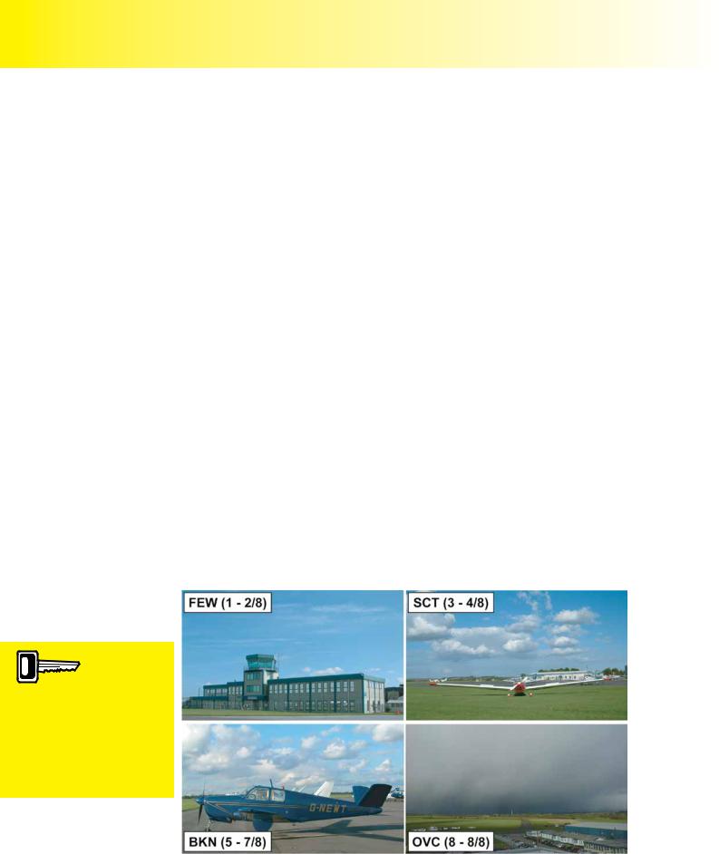
The next code-group to appear in the METAR gives detail of cloud coverage, as highlighted in red, in Figure 16.7, below.
METAR EGTK 211020Z 26012G25KT 1400 R30/1100 +SHRA OVC020CB
Figure 16.7 This highlighted code means “overcast sky, base 2000 feet, with cumulonimbus”.
There are several prefixes which are used to describe cloud amount, at any given level. Cloud coverage is reported in the METAR using the following three-letter codes:
•FEW (FEW) meaning one to two eighths of cloud coverage.
•SCATTERED (SCT) meaning three to four eighths of cloud coverage.
•BROKEN (BKN) meaning five to seven eighths of cloud coverage.
•OVERCAST (OVC) meaning complete cloud coverage, or eight eighths.
Figure 16.7 illustrates the different classifications of cloud coverage.
CLOUD
COVERAGE.
1/8 - 2/8 sky obscuration = FEW
3/8 - 4/8 sky obscuration = SCT
5/8 - 7/8 sky obscuration = BKN complete sky coverage = OVC
Figure 16.7 In the METAR, cloud is reported as FEW, SCT, BKN and OVC.
224

ID: 3658
Customer: Oleg Ostapenko E-mail: ostapenko2002@yahoo.com Customer: Oleg Ostapenko E-mail: ostapenko2002@yahoo.com
C H A P T ER 1 6 : T H
Cloud base is given as a three-digit figure showing hundreds of feet. Cloud base in a METAR is always measured as height above aerodrome level, using the current aerodrome QFE.
For example, 6 eighths of cloud (6 oktas) at 1 900 feet above aerodrome level would appear in the METAR as BKN019. 8 oktas at five hundred feet would be abbreviated to OVC005.
The only cloud types that are specified in the METAR are the significant convective clouds. These are cumulonimbus (CB) and towering cumulus (TCU).
Looking back to the cloud group, highlighted in Figure 16.7, we see the code OVC020CB. This refers to an overcast sky covered by cumulonimbus cloud whose base is 2 000 ft above aerodrome level. The previous weather group, +SHRA, indicates that the cloud detailed in the cloud group is producing a heavy shower of rain. If there is no cloud observed at the airfield, the code SKC, meaning sky clear, is used.
O b s c u r a t i o n .
If the sky at an aerodrome is obscured for reasons other than cloud cover, and cloud coverage cannot easily be determined, the code VV is used in place of the cloud information. VV is followed by the vertical visibility in hundreds of feet.
METAR EGTK 231020Z 26005KT 300FG OVC VV002
(a) (b) (c)
Figure 16.8 The highlighted codes in this METAR indicate that visibility is 300m in fog (a), the sky is overcast (b), and the vertical visibility is 200ft (c).
The METAR shown in Figure 16.8, decodes as follows:
METAR for Oxford/Kidlington, observed at 1020 UTC on 23rd of the month; the surface wind is 260º True, at 5 knots; the visibility is 300 m in fog (a); the sky is overcast (b), and a vertical visibility of 200 ft has been reported (c).
If the vertical visibility cannot be assessed, three forward slashes will replace the cloud height figures, e.g. VV///.
The code CAVOK is frequently used in the METAR code, being the abbreviation for “cloud, (or ceiling) and visibility are OK.” If CAVOK is used, it will replace the visibility, RVR, weather and cloud groups. There are four criteria which must be met in order for CAVOK to appear in the METAR. These are:
•the visibility must be 10 kilometres or more.
•the height of the lowest cloud must be no less than 5 000 feet, or the level of highest minimum sector altitude, whichever is the greater.
•there must be no cumulonimbus present.
•there must be no significant weather.
METAR EGTK 231020Z 26012G25KT 220V300 CAVOK
Figure 16.9 CAVOK - visibility is greater than 10km, there is no cloud below 5 000ft. No cumulonimbus are present, and there is no significant weather.
225

Order: 6026
Customer: Oleg Ostapenko E-mail: ostapenko2002@yahoo.com
Customer: Oleg Ostapenko E-mail: ostapenko2002@yahoo.com
C H A P T ER 1 6 : T H E M ET A R
T e m p e r a t u r e a n d De w P o i n t .
The temperature and dew point constitute the next group in the METAR code. The temperature and dew point code is simply a two-digit number giving the air temperature, with a forward slash, followed by another two-digit number which indicates the dew point. Both temperatures are measured in degrees Celsius. For example, the code 10/02 indicates that the air temperature is plus 10º C, and the dew point is plus 2º C. If either figure is negative, the prefix M will be used, as in 10/M02. The dew point in the example just given is minus 2º C.
METAR EGTK 231020Z 26012G25KT 220V300 CAVOK 10/M02
Figure 16.10 Temperature +10ºC, dew point -2ºC.
The METAR in Figure 16.10, above, decodes as follows:
METAR for Oxford/Kidlington, observed at 1020 UTC on 23rd of the month; the surface wind is 260º (True) at 12 knots, gusting to 25 knots and varying in direction from 220º (T) to 300º (T); the visibility is 10 km or more, with no cloud below 5
000 ft; there are no cumulonimbus and there is no significant weather at, or in the vicinity of, the aerodrome; the air temperature is +10º C and the dew point is -2º C.
Q NH .
The next METAR code is the QNH. The QNH will be represented by the letter Q, followed by a four digit number representing the actual pressure value. If the QNH is less than 1 000 millibars, the value will be preceded by a zero. For example, a QNH of 991 millibars would appear as Q0991. (See Figure 16.11).
METAR EGTK 231020Z 26012G25KT 220V300 9999 -RA FEW060 SCT120
10/M02 Q0991
Figure 16.11 QNH 991 millibars.
It is important to note that the only pressure value given in a METAR is the QNH. The QNH is always rounded down for safety reasons, if there are digits after the decimal point; for instance, if the QNH were 991.7 millibars, the QNH would be reported as
Q0991.
The METAR in Figure 16.11 decodes as follows:
METARforOxford/Kidlingtonobservedat1020UTCon23rdofthemonth;thesurfacewind is 260º (T) at 12 knots, gusting to 25 knots, and variable in direction from 220º (T) to 300º (T);theprevailingvisibilityis10kmormorewithlightrain;thereare1to2oktasofcloudat 6 000 ft and 3 to 4 oktas at 12 000 ft; the air temperature is +10º C and the dew point is -2º C; the QNH is 991 millibars.
R e c e n t W e a t h e r .
If there has been recent significant weather, either in the past hour, or since the last METAR was issued, and if the significant weather has ceased, or reduced in intensity, a METAR code group beginning with RE will appear. RE stands for recent. If there has been a thunderstorm during the hour, but which has now abated, giving only light rain, the present weather is reported as light rain, –RA; the fact that there have been thunderstorms in the past hour is reported by the four-letter code RETS:
226