

ppl_04_e2
.pdfID: 3658
Customer: Oleg Ostapenko E-mail: ostapenko2002@yahoo.com
Customer: Oleg Ostapenko E-mail: ostapenko2002@yahoo.com
C H A P T ER 1 0 : C L O U DS A ND
C o n v e r g e n c e .
If two masses of moving air (winds) converge with each other, the air will be forced to rise where the two air masses meet. This forced ascent will cause the air to cool adiabatically, possibly leading to condensation and the formation of cloud.
Figure 10.25 Lifting due to convergence on the Cornish peninsula.
The cloud formed within the zone of convergence will be of cumuliform type, similar to cloud formed by convection. An example of convergence is shown in Figure 10.25, caused by sea breezes on the Cornish peninsula, in Great Britain.
F r o n t a l L i f t i n g .
You have already learnt about how cloud forms in frontal systems. When a warm air mass meets a colder, denser air mass, the warm air will be forced to rise. In a warm front, the warm air rises over the cold air, and, in a cold front, the warm air is forced to rise by being undercut by the faster moving cold air mass. The rising warm air will cool, and its water vapour content will condense to create cloud.
Figure 10.26 Cloud formation.
Figure 10.26 depicts both the warm and cold fronts which are associated with a polar depression. As you have learnt, cumulus and cumulonimbus are often created in advance of the cold front.
137
Order: 6026
Customer: Oleg Ostapenko E-mail: ostapenko2002@yahoo.com
Customer: Oleg Ostapenko E-mail: ostapenko2002@yahoo.com
C H A P T ER 1 0 : C L O U DS A ND P R EC IP IT A T IO N
O r o g r a p h i c C l o u d .
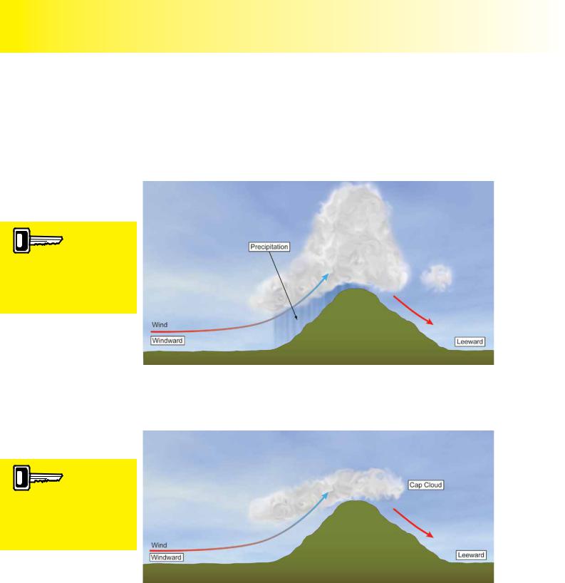
High ground, hills and mountains will also force air to rise when wind is present, causing cloud to form over the hills if the air is cooled to its dew point. This type of cloud is called orographic cloud (from Greek oros meaning mountain). The type of orographic cloud which forms will depend on the stability of the air. In an unstable atmosphere, orographic cloud will continue to develop vertically to form cumuliform cloud, and even cumulonimbus. (See Figure 10.27.)
If unstable air is forced
to rise up the side of a
mountain, it will continue to rise once it has reached the peak, and cumuliform cloud will be created.
Figure 10.27 Cumuliform cloud may be embedded in orographic cloud, in unstable conditions.
In stable conditions, orographic cloud will not develop vertically, but will tend to hug the high ground forming what is known as cap cloud. (See Figure 10.28.)
In stable atmospheric
conditions, orographic
cloud remains stratiform, producing what is known as cap cloud on hill and mountain tops.
Figure 10.28 In stable air cap cloud will be formed.
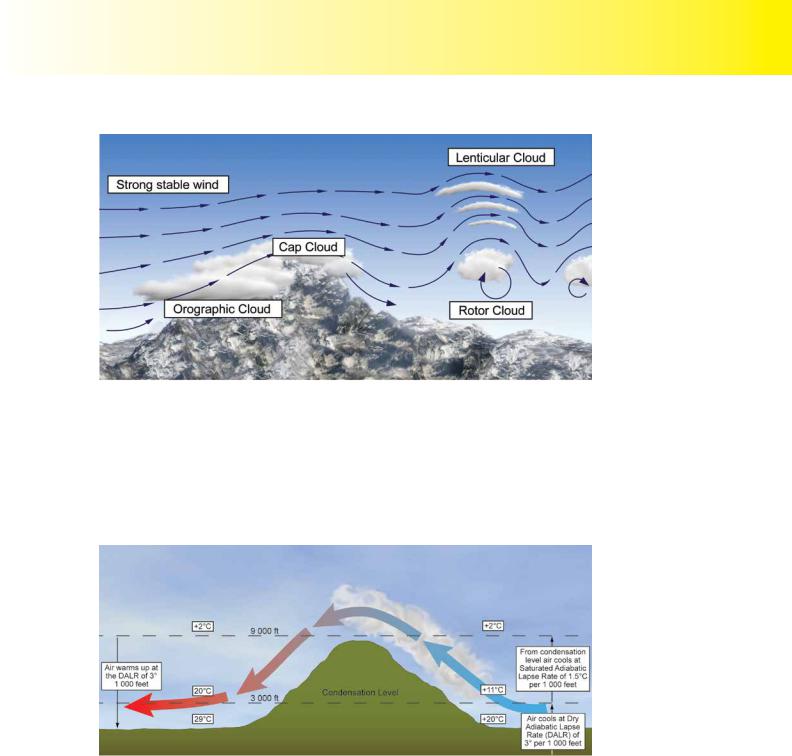
L e n t i c u l a r a n d R o t o r C l o u d s .
When an air mass moves over hills or mountain ranges, stable conditions can create standing waves, with their associated lenticular and rotor clouds. You learnt about this phenomenon in Chapter 9.
Figure 10.29 illustrates the different types of cloud associated with hills and mountains, in stable atmospheric conditions.
138
ID: 3658
Customer: Oleg Ostapenko E-mail: ostapenko2002@yahoo.com
Customer: Oleg Ostapenko E-mail: ostapenko2002@yahoo.com
C H A P T ER 1 0 : C L O U DS A ND
Figure 10.29 Cloud associated with airflow over a mountain, in stable conditions.
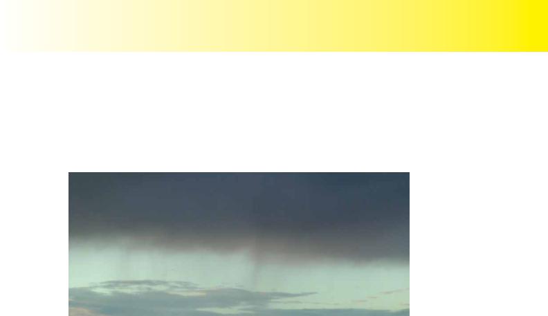
THE FÖHN EFFECT.
Stable air flowing over a mountain may also give rise to what is known as the Föhn Effect and its associated cloud and wind. The term Föhn wind describes a wind blowing down the lee of a mountainside, and which is warmer and drier than the air moving up the windward side of the mountain, at the same height.
Figure 10.30 The Föhn wind and the Föhn effect.
Figure 10.30 depicts moist air moving up the windward side of the mountain. First of all, the air is unsaturated and, as it rises up the mountainside, it cools at the Dry Adiabatic Lapse Rate (DALR) of 3° per 1 000 feet. When the air becomes saturated, however, cloud will form, possibly accompanied by precipitation, and, from that point, the air will continue to cool at the lower Saturated Adiabatic Lapse Rate (SALR) of 1.5°C per 1 000 ft. When the air descends on the leeward side of the mountain, it will have lost much of its water vapour content through the formation of cloud, and precipitation. Consequently, the descending air will heat up at the DALR of 3° per 1 000 feet, giving rise to warm, dry valley winds.
Föhn winds and the Föhn Effect are common phenomena in the Alps.
139

Order: 6026
Customer: Oleg Ostapenko E-mail: ostapenko2002@yahoo.com
Customer: Oleg Ostapenko E-mail: ostapenko2002@yahoo.com
C H A P T ER 1 0 : C L O U DS A ND P R EC IP IT A T IO N
PRECIPITATION.
Drizzle is the type of
precipitation most
commonly associated with stratus.
Precipitation is the name given to liquid and solid water particles which fall to the Earth’s surface from clouds. Precipitation may take the form of drizzle, rain, snow or hail. As you have learnt, clouds are formed when water-vapour condenses and forms water droplets. The only real difference between the water droplets which make up the cloud and the water particles which fall from cloud as precipitation is one of size and weight.
C o n d e n s a t i o n a n d C o a l e s c e n c e .
In order for precipitation to occur, condensation must first take place.
Condensation requires the presence of condensation nuclei (see Chapter 8). As the air cools, water vapour condenses into visible water droplets around these nuclei. However, these droplets frequently remain very very small, and are retained in the cloud, itself, by upcurrents. These minute droplets are, of course, essentially, the very substance of the cloud, itself. If they grow heavy enough so that they are just able to fall from the cloud, precipitation may result in the form of fine drizzle. The cloud commonly producing drizzle is stratus. Stratus has very little vertical development and contains only weak updraughts, so the water particles which fall from stratus are always very fine.
Water droplets produced by condensation, however, frequently continue to grow, because of processes within the cloud, itself. Droplets frequently collide and merge to form larger droplets which may be held suspended in cumuliform cloud until they are heavy enough to fall as rain. The process of water droplet growth through collisions is called coalescence. The size that droplets grow to before falling as rain will depend on the strength of the up-currents within the cloud. Powerful vertical upcurrents will support much larger droplets, and produce heavier rain. Cumulonimbus contain the strongest upcurrents and produce the heaviest, most intense, precipitation.
Though it is a generalisation, the average raindrop may be considered to possess a mass of about 1 000 000 times greater than a water droplet which forms a cloud.
The type and intensity of
precipitation depends
largely on the strength and extent of the vertical air movement inside a cloud. Hence, s t r awillt produces
drizzle, c u m |
uwill produces |
rain and c u m |
u l o nwilli m |
produce heavy rain or hail. Precipitation falls as snow if the temperature is below zero.
R a i n a n d S n o w - T h e B e r g e r o n P r o c e s s
The Bergeron Process (named after the physicist Tor Bergeron) describes the process whereby, in those parts of a cloud where the temperature is lower than 0°C, water vapour sublimates directly into ice crystals. Ice crystals continue to grow and eventually become heavy enough to fall through the cloud. The ice crystals may then start to melt, and amalgamate into large clusters of ice crystals to form snow. As the snow falls, the air temperature may rise above freezing level, causing the snow to melt to become rain.
T h e F o r m a t i o n a n d G r o w t h o f H a i l .
Hail is formed when rain droplets are carried by strong updraughts rapidly to the top b u s
of a cloud, usually cumulonimbus, causing the droplets to freeze into hail stones.
The small hail stones will then begin to fall again, before being swept back upwards as they are caught in the stronger upcurrents feeding the base of the cloud. In this way, hail stones will grow through collision with other water droplets, by the process of coalescence.
Hailstones grow layer by layer, through the process of coalescence, and may become very large indeed before they fall to Earth from the cloud. Hailstones weighing up
140
ID: 3658
Customer: Oleg Ostapenko E-mail: ostapenko2002@yahoo.com
Customer: Oleg Ostapenko E-mail: ostapenko2002@yahoo.com
C H A P T ER 1 0 : C L O U DS A ND
to 1 kg have been known to form in cumulonimbus, posing a real hazard to aviation. As has been stated several times in this book, pilots should give cumulonimbus a wide berth.
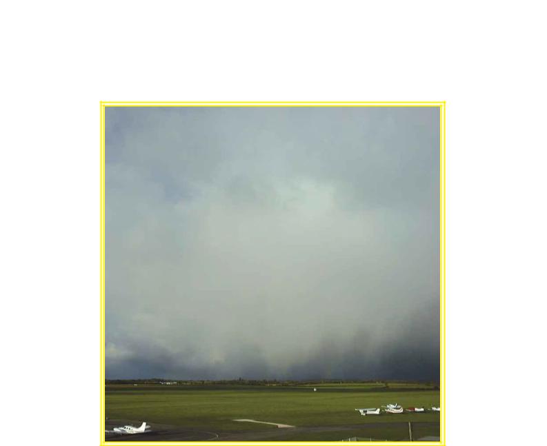
V i r g a .
Virga is precipitation which is falling, but not reaching the ground, and looks like tendrils hanging beneath the cloud.
Figure 10.31 Virga.
T h e Na t u r e o f P r e c i p i t a t i o n .
Precipitation may take on various forms, such as rain, hail, snow etc, and may also fall to the Earth’s surface in different ways, either steadily, over a long period of time
(dynamic precipitation), or intensely and briefly as a shower.
Showers develop in unstable atmospheric conditions and fall from large cumulus (cumulus congestus) and cumulonimbus clouds. As you have already learnt, these clouds have active, powerful updraughts within them, helping to support large water and ice particles. This fact explains why showers of rain tend to consist of large rain droplets.
The convective cells making up cumulus congestus and cumulonimbus move over the surface at the speed of mid-altitude winds causing showers to have a relatively sharp onset and cessation. Showers can be of rain, snow or hail.
Dynamic precipitation is characterised by its more gentle onset, its duration of several hours, and gradual cessation. Dynamic precipitation falls from layered cloud, as opposed to showers which fall from convective cloud. Dynamic precipitation may take the form of drizzle, rain, snow or sleet. Dynamic precipitation can be described as being intermittent, falling from time to time for usually less than 60 minutes, or continuous, lasting for 60 minutes or more at any one location.
C l a s s i f i c a t i o n o f t h e In t e n s i t y o f P r e c i p i t a t i
The intensity of precipitation is described using the words: light, moderate and heavy.
Light rain is described as less than 0.5 mm per hour, whereas heavy rain is greater than 4 mm (1/6 of an inch) per hour.
Snow fall is measured in centimetres, or inches, of accumulation per hour.
141

Order: 6026
Customer: Oleg Ostapenko E-mail: ostapenko2002@yahoo.com
Customer: Oleg Ostapenko E-mail: ostapenko2002@yahoo.com
C H A P T ER 1 0 : C L O U DS A ND P R EC IP IT A T IO N Q U ES T IO
R e p r e s e n t a t i v e P P L - t y p e k n o w l e d g e o f C l o u d s a n d
q u e s t i o n P r e c i p i t a t
1Unstable air is forced to rise up the side of a mountain. What weather might you expect to see on the windward slopes?
a.Cloud of extensive vertical development embedded in orographic cloud
b.Thick stratiform cloud, possibly nimbostratus
c.None, as the air will subside and warm adiabatically after passing over the summit
d.Cap clouds with possible altocumulus lenticularis
2.Meteorological textual information defines the height of the cloud base as follows: (agl = above ground level; amsl = above mean sea-level)
a.METAR – agl, TAF – amsl, Area Forecast – amsl
b.METAR – agl, TAF – agl, Area Forecast – amsl
c.METAR – amsl, TAF – amsl, Area Forecast – agl
d.METAR – amsl, TAF – agl, Area Forecast – agl
3.The use of the suffix “nimbus” or prefix “nimbo” means:
a.dark and threatening
b.wispy, detached or fibrous
c.medium cloud
d.rain bearing
4.The precipitation produced by stratus is normally:
a.heavy showers
b.heavy rain
c.drizzle
d.light showers
5.Hail is most likely to fall from which type of cloud?
a.NS
b.AC
c.CB
d.AS
6.Which of the following clouds is most closely associated with extensive light rain?
a.Nimbostratus
b.Cumulus
c.Cumulonimbus
d.Cirrostratus and stratocumulus
142

ID: 3658
Customer: Oleg Ostapenko E-mail: ostapenko2002@yahoo.com
Customer: Oleg Ostapenko E-mail: ostapenko2002@yahoo.com
C H A P T ER 1 0 : C L O U DS A ND P R EC IP
7.From the list below, select the Low, Medium and High clouds in ascending order.
a.Stratus, altocumulus, cirrus
b.Nimbostratus, cumulonimbus, cirrus
c.Altostratus, altocumulus, cirrus
d.Cirrus, cumulonimbus, stratus
8.Given a surface temperature of +21° C and a dew point of +6° C, at approximately what height will the cloud base of a cumulus cloud be?
Use the UK CAA’s formula for calculating height of cloud base.
a.560 ft
b.56 000 ft
c.4 000 ft
d.5 000 ft
9.One or more coloured rings around the Sun or Moon may indicate the presence of which type of cloud?
a.High
b.Cirrostratus
c.Stratus
d.Cirrocumulus
10.What type of weather phenomenon would you expect in a valley on the leeward side of a mountain over which a Föhn wind was blowing?
a.Heavy precipitation
b.A warm, dry wind
c.A cold, moist wind
d.Valley fog
11.Lenticular clouds observed in the lee of a range of hills indicate the possibility of what type of meteorological phenomenon?
a.Strong upcurrents in the lee of the hills
b.Severe downdraughts on the immediate windward side of the hills
c.Severe downdraughts in the immediate lee of the hills and turbulent rotor clouds beneath the lenticular cloud
d.the imminent development of cumulonimbus
12.An unstable atmosphere where the Environmental Lapse Rate is greater than the Saturated Adiabatic Lapse Rate, is characterised by:
a.clear skies and heat haze
b.a predominance of cirrostratus and altostratus with no low level cloud
c.fog with an almost complete absence of wind
d.extensive cumulus or cumulonimbus cloud with frequent showers and otherwise good visibility
143

Order: 6026
Customer: Oleg Ostapenko E-mail: ostapenko2002@yahoo.com
Customer: Oleg Ostapenko E-mail: ostapenko2002@yahoo.com
C H A P T ER 1 0 : C L O U DS A ND P R EC IP IT A T IO N Q U ES T IO
13.Heavy showers of rain and the possibility of thunderstorms are most often associated with cloud:
a.in advance of a cold front
b.behind a warm front
c.in advance of a warm front
d.within a ridge of high pressure
14.A stable air mass which is subject to orographic lifting will most likely produce:
a.cloud of extensive vertical development
b.stratiform cap cloud at the summit of the high ground
c.no cloud because the air is stable
d.warm, dry, valley winds
Question |
1 |
2 |
3 |
4 |
5 |
6 |
7 |
8 |
9 |
10 |
11 |
12 |
|
|
|
|
|
|
|
|
|
|
|
|
|
|
|
Answer |
|
|
|
|
|
|
|
|
|
|
|
|
|
|
|
|
|
|
|
|
|
|
|
|
|
|
|
Question |
13 |
14 |
|
|
|
|
|
|
|
|
|
|
|
|
|
|
|
|
|
|
|
|
|
|
|
|
|
Answer |
|
|
|
|
|
|
|
|
|
|
|
|
|
T h e a n s w e r s t o t h e s e q u e s t i o n s c a n b e
144
Customer: Oleg Ostapenko E-mail: ostapenko2002@yahoo.com
CHAPTER 11
THUNDERSTORMS
145

Order: 6026
Customer: Oleg Ostapenko E-mail: ostapenko2002@yahoo.com
Customer: Oleg Ostapenko E-mail: ostapenko2002@yahoo.com
C H A P T ER 1 1 : T H U NDER S T O R M S
146