

ppl_04_e2
.pdfID: 3658
Customer: Oleg Ostapenko E-mail: ostapenko2002@yahoo.com
Customer: Oleg Ostapenko E-mail: ostapenko2002@yahoo.com
C H A P T ER 1 2 : L O W L
Put simply the surface winds will move between these two extremes depending on the time of day. From 0600 onwards the surface wind will increase in strength and move towards the 1500 position. But after 1500 hours the wind will slowly decrease and move towards the 0600 position. (See Figure 12.12a).
Figure 12.12a Diurnal Variation of the Surface Wind.
As thermal mixing increases during the
day the surface wind speed becomes closer to the geostrophic wind speed and so does the Coriolis force affecting it. As these both increase the surface wind will veer towards the direction of the geostrophic wind. As the thermal mixing decreases over night the surface wind speed is reduced by friction; this reduces its Coriolis force and the wind backs and decreases.
LOCAL WINDS.
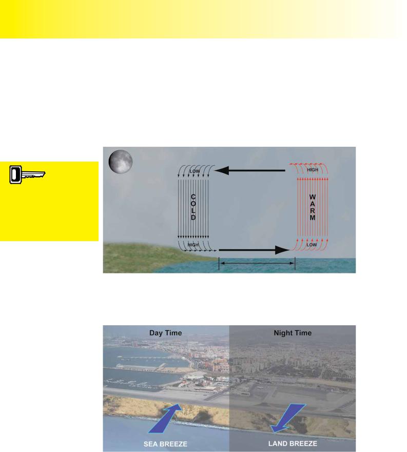
The rest of this chapter deals with more localised winds. The first of these are land and sea breezes. Land and sea breezes are local winds that can be found along coastlines, particularly, but not exclusively, in the tropics. Land and sea breezes only occur when the general wind conditions are slack and there are no major pressure systems dominating the coastal regions.
S e a B r e e ze s .
Figure 12.13 shows a cross section of the land and sea during the day. The land will heat up faster than the sea and will therefore be warmer. As a result there will be warmer, less dense air above the land surface than above the surface of the sea.
Figure 12.13 The Sea Breeze.
167
|
Order: 6026 |
Customer: Oleg Ostapenko E-mail: ostapenko2002@yahoo.com |
|
Customer: Oleg Ostapenko E-mail: ostapenko2002@yahoo.com |
|
C H A P T ER 1 2 : L O W |
L EV EL W INDS |
This warm air over the land will start to rise and the cooler air over the sea will tend to sink. This will gradually set up a small scale cycle of air up to about 1 000 ft as shown. Notice that at the surface the wind will blow from the sea to the land, and hence be called a “sea breeze”. This wind will reach its maximum strength when the lands is hottest which will be at about 15:00 local time.
L a n d B r e e ze s .
The process is reversed at night. Figure 12.14 shows a cross section of the land and sea during the night.
During the day the
land surface becomes
warmer than the sea and the surface wind blows form sea to land, a sea breeze. At night the situation is reversed and the breeze blows from land to sea, a land breeze.
Figure 12.14 The Land Breeze.
The land will cool down faster than the sea. As a result there will be warmer, less dense air above the sea surface than above the land. This air will be heated and start to rise. This situation will cause a localised reduction in pressure and air will start to be drawn in from over the land towards the sea.
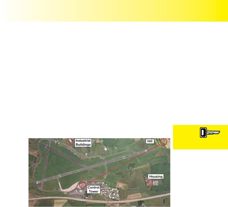
Figure 12.15 The sea breeze and the land breeze will produce a cross wind day and night at this coastal airfield.
The airflow from the land to the sea is known as a land breeze, and its strength will be maximum just after sunrise where we have the minimum land surface temperatures.
Again this flow of air creates a circulation pattern up to approximately 1 000 ft.
168
ID: 3658
Customer: Oleg Ostapenko E-mail: ostapenko2002@yahoo.com
Customer: Oleg Ostapenko E-mail: ostapenko2002@yahoo.com
C H A P T ER 1 2 : L O W L
Land and sea breezes are particularly important to coastal airfields. Shown in Figure 12.15 is an airfield near the sea with a runway parallel to the coastline. During the night and day, the sea and land breeze effect will always produce a wind across the runway, but remember that sea and land breezes will only develop when there is a weak pressure gradient, but are still subject to Coriolis force, and will, if persistent, end up blowing parallel to the coast.
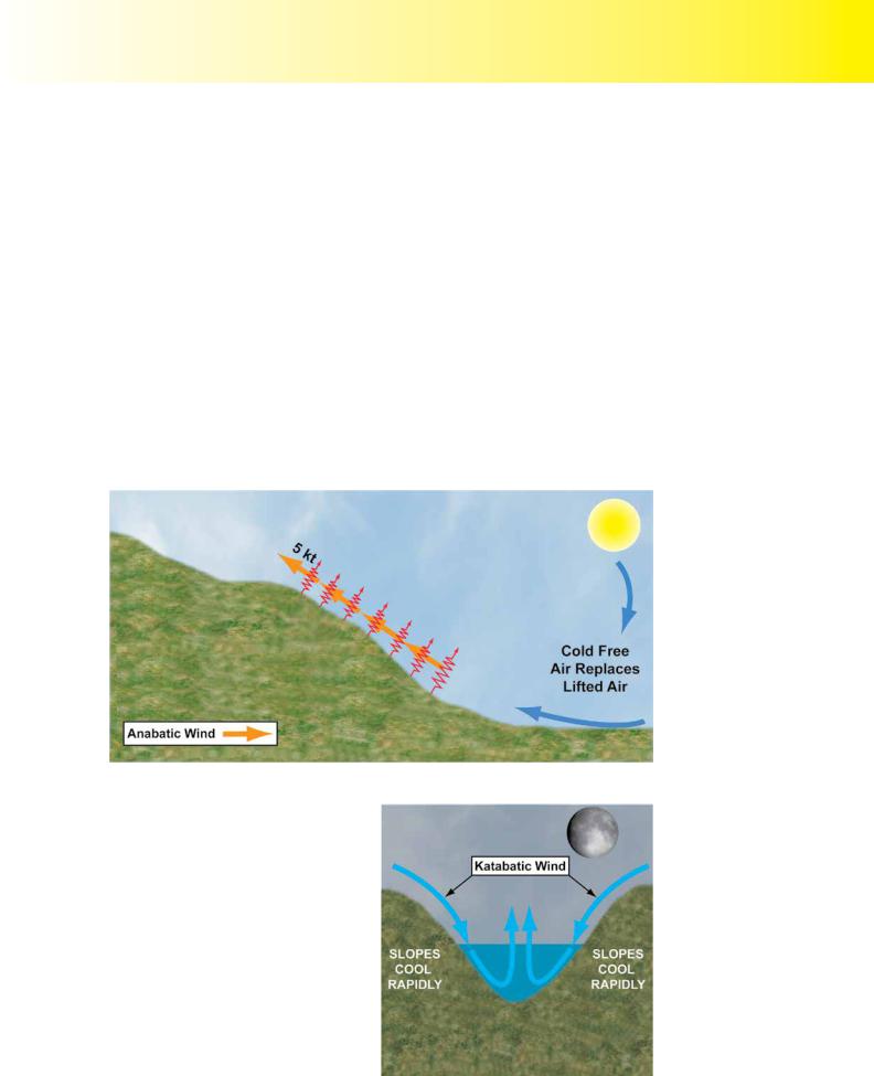
A n a b a t i c W i n d s .
There are another two other types of localised winds worth a mention. Again, these only occur when the general wind conditions are slack and there are no major pressure systems dominating the region. They are anabatic and katabatic winds.
On the sloping terrain in Figure 12.16, during the day, the land will warm and in turn warm the air adjacent to the surface.
This air will be less dense and start to flow up the slope, to be replaced by cold air flowing in from elsewhere. These upward flowing winds are called Anabatic winds.
Sometimes clouds on the top of the ridges are signs that anabatic winds are present. Always treat mountain ridges with extra caution regardless of the presence or lack
of clouds.
Figure 12.16 Anabatic Wind Formation
K a t a b a t i c W i n d s .
During the night the process is reversed. The surface of the slope will cool faster than the air in the valley and the air overlying it will become heavier and denser. As a result it will sink down the sloping terrain and collect in the valley bottom below. This wind is called a Katabatic wind as illustrated in Figure 12.17. Throughout the night, cold air will continue to collect in the valley. If the dew point is reached this can lead to the formation of valley fog.
Figure 12.17 Katabatic Wind Formation
169
|
Order: 6026 |
Customer: Oleg Ostapenko E-mail: ostapenko2002@yahoo.com |
|
Customer: Oleg Ostapenko E-mail: ostapenko2002@yahoo.com |
|
C H A P T ER 1 2 L O W |
L EV EL W INDS |
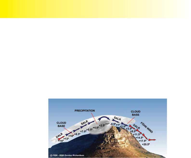
T h e F ö h n Ef f e c t .
A Föhn wind is caused when stable air flows over a mountain and descends on the other side. As air is forced over a mountain it will cool at the dry adiabatic lapse rate of 3ºC per 1 000 feet. If the dew point is reached then cloud will form. From then on, if forced ascent continues it cools at the Saturated adiabatic lapse rate of 1.5ºC per 1 000 feet. There may be precipitation produced on the windward slope which reduces the water content of the air mass. However, because the air is stable, it will flow back down the leeward side of the mountain and as it descends it will warm adiabatically.
At first it warms at the saturated adiabatic lapse rate until the cloud disperses and then at the dry adiabatic lapse rate as it descends further.
Notice that the air on the leeward side is mostly warming at the DALR rate of 3°C per 1 000 ft. This creates some unique effects. If the air on the windward side cooled mainly at 1.5°C per 1 000 ft but when it descended on the leeward side it warmed at 3°C per 1 000 ft then the air at the base of the leeward side will have become much warmer than when it started on the windward side. (See Figure 12.18).
Figure 12.18 The Föhn Wind Effect.
The Föhn wind is a fairly common occurrence in the Southern Alps especially so in winter as the air from mainland Europe gets drawn up and over the mountains into the Mediterranean. These winds can cause major problems in certain areas of the world causing large scale rapidly moving forest fires and this is famously apparent in
California around Los Angeles where this wind is called the “Santa Ana”.
This completes the chapter on low level winds. Surface winds are always best understood when comparing them to the geostrophic wind and so a good comprehension of how the geostrophic wind occurs and of the modifications it undergoes in the friction layer are essential. When examining a pressure chart to find the winds to help in flight planning, do not forget also to bear in mind the local effects of hills, valleys and sloping terrain. These may significantly alter the wind from what is suggested by the surface pressure charts.
170

ID: 3658
Customer: Oleg Ostapenko E-mail: ostapenko2002@yahoo.com
Customer: Oleg Ostapenko E-mail: ostapenko2002@yahoo.com
C H A P T ER 1 2 : L O W L EV EL W
R |
e p r e s e n t a t i v e P P L - t y p e |
|
k n o w l e d g e o f |
L o w L e v e l W |
|
q u e s t i o n s t o t i n d s .
1.At about mid-afternoon the surface wind at an aerodrome was reported as 220/25. using the rule of thumb, what might you expect the 2,000 ft wind to be?
a.205/50
b.205/15
c.245/50
d.235/12
2.Low level winds in the northern hemisphere that blow around a depression are drawn on surface weather charts in:
a.A clockwise direction
b.An anti-clockwise direction
c.An anti-cyclonic direction
d.Either clockwise or anti-clockwise depending on whether the depression is cyclonic or ant-cyclonic
3.How would the wind in the evening be described compared to the surface wind at 1600 local time?
a.Veered and decreased
b.Backed and increased
c.Backed and decreased
d.Veered and increased
4.Winds that blow round an anti-cyclone (high pressure system) at low levels in the northern hemisphere are represented on a low level chart as blowing in:
a.A clockwise direction
b.A clockwise direction if it is warm air and anti-clockwise if it is cold air
c.An anti-clockwise direction
d.A cyclonic direction
5.Select the statement that is most representative of land and sea breezes.
a.The surface wind is likely to blow on-shore during the day
b.The surface wind is likely to blow on-shore during the night
c.By day the 1000 ft wind is likely to blow on-shore
d.They can only be observed in strong pressure gradient forces
6.A pressure gradient causes air to move:
a.Between the high pressure and the low pressure
b.From a cyclonic region to an anti-cyclonic region
c.From low pressure to high pressure
d.From an anti-cyclonic region to a cyclonic region
171

|
Order: 6026 |
Customer: Oleg Ostapenko E-mail: ostapenko2002@yahoo.com |
|
Customer: Oleg Ostapenko E-mail: ostapenko2002@yahoo.com |
|
C H A P T ER 1 2 : L O W |
L EV EL W INDS Q U ES T IO NS |
7.The wind over an aerodrome was reported as 330/15. Using the rule of thumb, what might you expect the surface wind to be.
a.305/30
b.355/30
c.315/30
d.307/7
8.The latest weather report for an aerodrome on the south coast indicates
asea breeze. If your ETA is mid-afternoon, on what runway might
you expect an into wind landing?
a.09
b.35
c.18
d.27
9.Coriolis force in the northern hemisphere will cause moving air to be apparently deflected to:
a.The left and cause the wind to blow parallel to the isobars at about 2 000 ft agl
b.The right and cause the wind to blow parallel to the isobars at about 2 000 ft agl
c.The left and cause the wind to blow slightly across the isobars at about 2,000 ft agl
d.The right and cause the wind to blow slightly across the isobars at about 2 000 ft agl
10.Which of the following types of weather report or forecast give the wind direction with respect to true north.?
a.TAF, ATIS, AIRMET
b.METAR, ATIS, SIGMET
c.TAF, METAR, VOLMET
d.METAR, TAF, ATIS
Question |
1 |
2 |
3 |
4 |
5 |
6 |
7 |
8 |
9 |
10 |
|
|
|
|
|
|
|
|
|
|
|
Answer |
|
|
|
|
|
|
|
|
|
|
T h e a n s w e r s t o t h e s e q u e s t i o n s c a n b e
172
Customer: Oleg Ostapenko E-mail: ostapenko2002@yahoo.com
CHAPTER 13
VISIBILITY AND FOG
173

Order: 6026
Customer: Oleg Ostapenko E-mail: ostapenko2002@yahoo.com
Customer: Oleg Ostapenko E-mail: ostapenko2002@yahoo.com
C H A P T ER 1 3 : V IS IB IL IT Y A ND F O G
174
ID: 3658 |
|
Customer: Oleg Ostapenko E-mail: ostapenko2002@yahoo.com |
|
Customer: Oleg Ostapenko E-mail: ostapenko2002@yahoo.com |
1 3 : V IS IB IL IT |
C H A P T ER |
INTRODUCTION.
Pilots who do not possess an instrument qualification fly solely by visual reference to features outside the cockpit.
Visibility, then, is of the greatest importance to pilots who fly in accordance with the Visual Flight Rules (VFR). Visibility also has significant influence on the legality of landing and take-off.
‘Meteorological Visibility’ is described as: the greatest horizontal distance at which a defined object can be recognised by an observer with normal eyesight, during daylight. At night, visibility is defined by the distance over which lights of a specified candlepower can be distinguished by the naked eye.
Visibility may also be expressed in terms of the degree of clarity or obscurity of the atmosphere.
MEASUREMENT OF VISIBILITY.
Visibility is measured in metres or kilometres. By day, surface visibility is measured by reference to suitable objects at known distances from the observation point. (See Figure 13.1.)
Figure 13.1 The surface visibility at an aerodrome is determined by the observation of features at known distances from an observation point.
At aerodromes, the observation point is normally in, or adjacent to, the Air Traffic
Control tower.
In-flight visibility is defined as the forward visibility measured from the cockpit of an aircraft in flight. In-flight visibility is generally greater than surface visibility.
The general VFR minimum visibility below which VFR flight is prohibited, outside controlled airspace, is 3 kilometres. In the United Kingdom, under certain circumstances, VFR flight is allowed, outside controlled airspace, with an in-flight visibility of 1.5 kilometres. (See Volume 1, Air Law.)
In meteorological reports, visibility is not always given as being of the same value measured in all directions. At present, in the United Kingdom, the concept of prevailing visibility has been adopted by the Met Office for aerodrome weather reports. Prevailing visibility is dealt with in Chapter 16.
Visibility is a measure of atmospheric clarity or obscurity.
175
Order: 6026
Customer: Oleg Ostapenko E-mail: ostapenko2002@yahoo.com
Customer: Oleg Ostapenko E-mail: ostapenko2002@yahoo.com
C H A P T ER 1 3 : V IS IB IL IT Y A ND F O G
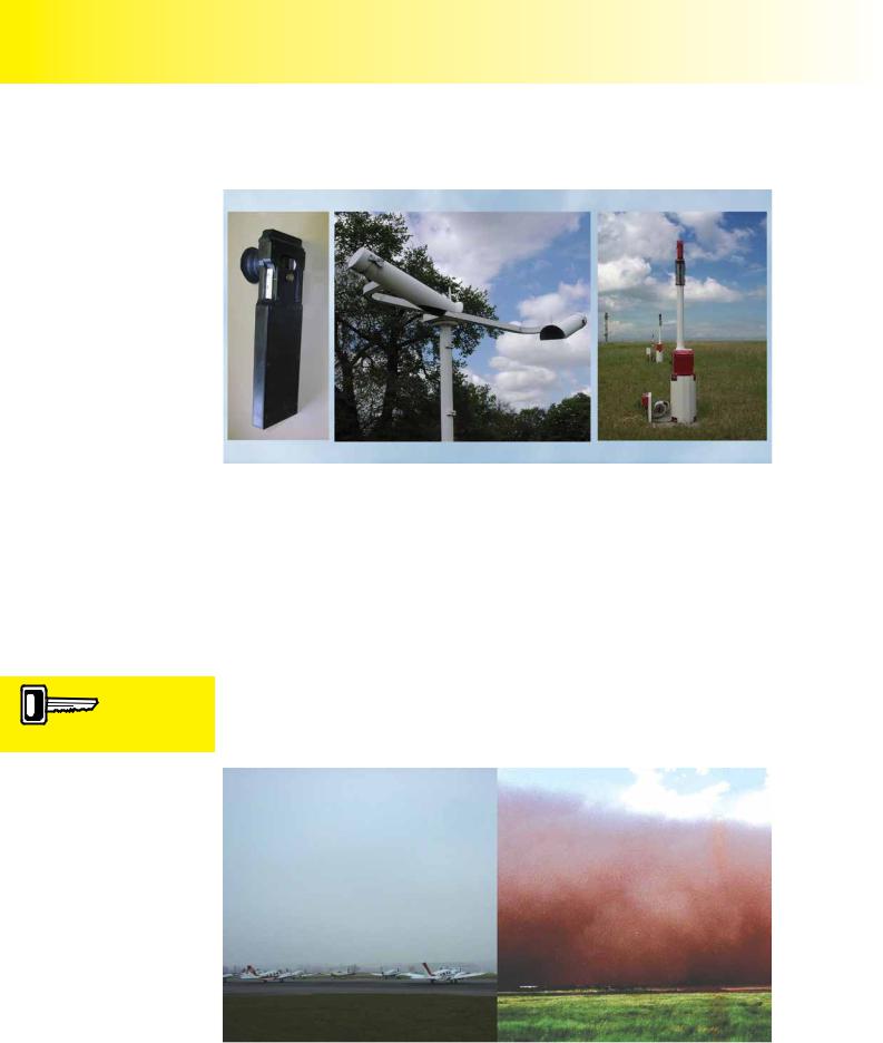
Visibility can be measured accurately, using instruments such as the Gold Visibility
Meter, the Visiometer and the Transmissometer. (See Figure 13.2.)
Smog is a combination of fog and smoke obscuration.
Figure 13.2 Gold Visibility Meter, Visiometer, Transmissometer.
OBSCURATIONS.
Atmospheric phenomena which degrade visibility are referred to as obscurations. There are two principal types of obscuration in the atmosphere.
The first type of obscuration is caused by the presence of water droplets; these can either be suspended in the form of cloud, mist or fog, or be falling as precipitation, for example, as snow, rain or drizzle.
Solid particles such as dust, smoke or sand, constitute the second type of obscuration.
Visibility may also be obscured by a combination of solid matter and water droplets. This type of obscuration is referred to as smog.
Figure 13.3.
Fog: obscuration through water droplets Dust obscuration. suspended in the atmosphere.
176