

4 |
Layout and connectivity
Tim Pharoah, Llewelyn Davies Yeang
Chapter aims
•Set out design concepts for the structuring of towns and cities.
•Set out principles for walkable neighbourhoods.
•Illustrate appropriate layouts and street forms.
•Consider internal permeability and external connectivity.
•Give advice on crime prevention.
4.1Planning for things you cannot easily change later
4.1.1The way streets are laid out and how they relate to the surrounding buildings and spaces has a great impact on the aesthetic and functional success of a neighbourhood. Certain elements are critical because once laid down, they cannot easily be changed. These issues are considered in the masterplanning and design coding stage, and need to be resolved before detailed design is carried out.
4.1.2This chapter highlights the issues likely to be encountered in developing detailed designs, and ways of dealing with them. There are also tips on avoiding unwanted consequences of particular design decisions.
Bus stop |
Principal routes |
Internal streets |
4.2The movement framework
4.2.1A key consideration for achieving sustainable development is how the design can influence how people choose to travel. Designers and engineers need to respond to a wide range of policies aimed at making car use a matter of choice rather than habit or dependence. Local transport plans and movement strategies can directly inform the design process as part of the policy implementation process (Wales: Regional Transport Plans and Local Development Plans).
4.2.2It is recommended that the movement framework for a new development be based on the user hierarchy as introduced in Section 3.6. Applying the hierarchy will lead to a design that increases the attractiveness of walking, cycling and the use of public transport. Delays
to cars resulting from adopting this approach are unlikely to be significant in residential areas. The movement framework should also take account of the form of the buildings, landscape and activities that form the character of the street and the links between new and existing routes and places (Fig. 4.1).
4.2.3Street networks should, in general, be connected. Connected, or ‘permeable’, networks encourage walking and cycling, and make places easier to navigate through. They also lead to a more even spread of motor traffic throughout the area and so avoid the need for distributor roads with no frontage development. Research2 shows that there is no significant difference in collision risk attributable to more permeable street layouts.
1Llewelyn Davies (2000)
The Urban Design Compendium. London: English Partnerships and
The Housing Corporation.
2I York, A Bradbury, S Reid, T Ewings and R Paradise (2007) The Manual
for Streets: Redefining Residential Street Design. TRL Report No. 661. Crowthorne: TRL.
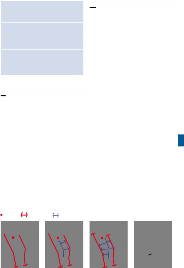
Consider how best the site can be |
The typical cul-de-sac response |
A more pedestrian friendly approach |
connected with nearby main routes |
creates an introverted layout which |
that integrates with the surrounding |
and public transport facilities. |
fails to integrate with its surroundings. |
community. It links existing and |
|
|
proposed streets and provides direct |
|
|
routes to bus stops. |
Figure 4.1 Integrating new developments into the existing urban fabric is essential (source: The Urban Design Compendium1).
This street pattern then forms the basis for perimeter blocks which ensure that buildings contribute positively to the public realm.
Manual for Streets |
41 |

4.2.4 Pedestrians and cyclists should generally be accommodated on streets rather than routes segregated from motor traffic. Being seen by drivers, residents and other users affords a greater sense of security. However, short pedestrian and cycle-only links are generally acceptable if designed well. Regardless of length, all such routes in built-up areas, away from the carriageway, should be barrier-free and overlooked by buildings. Narrow routes hemmed in by tall barriers should be avoided as they can feel claustrophobic and less secure for users.
Connecting layouts to their surroundings
4.2.5Internal permeability is important but the area also needs to be properly connected with adjacent street networks. A development with poor links to the surrounding area creates an enclave which encourages movement to and from it by car rather than by other modes (Fig. 4.2).
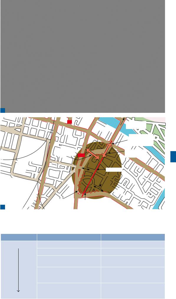
4.2.6External connectivity may often be lacking, even where layouts generally have good internal permeability. Crown Street, Glasgow, is shown in Fig. 4.3, with an indication of where connectivity was not realised as may have been intended in the masterplan.
4.2.7The number of external connections that a development provides depends on the nature of its surroundings. Residential areas adjacent to each other should be well connected.
4.2.8To create a permeable network, it is generally recommended that streets with one-way operation are avoided.They require additional signing and result in longer vehicular journeys.
The hierarchies of provision
4.2.9 If road safety problems for pedestrians or cyclists are identified, conditions should be reviewed to see if they can be addressed, rather than segregating these users from motorised traffic. Table 4.1 suggests an ordered approach for the review.
Stephen Marshall
Figure 4.2 Internally permeable neighbourhoods lacking direct connections with one another (source: Marshall 2005 3).
4.2.10These hierarchies are not meant to be rigidly applied and there may be situations where it is sensible to disregard some of the solutions when deciding on the optimum one. For example, there would be no point in considering an at-grade crossing to create a pedestrian/ cyclist link between developments on either side of a motorway. However, designers should not dismiss out of hand solutions in the upper tier of the hierarchy.
4.2.11It is recommended that the hierarchies are used not only for a proposed scheme but also for connections through existing networks to local shops, schools, bus stops, etc.
4.3Building communities to last
4.3.1 Good design is a key element in achieving the Government’s aim to create thriving, vibrant, sustainable communities.
Sustainable communities meet the diverse needs of existing and future residents, are sensitive to their environment by minimising their effect on climate change, and contribute to a high quality of life. They are safe and inclusive, well planned and promote social inclusion, offering equality of opportunity and good services for all.
3Marshall, S. (2005)
Streets and Patterns. London: Spon Press. Figure 2.10, p.34.
42 |
Manual for Streets |
a
b

 A8
A8 
Poor quality connection
Development walled off in this area
|
E |
T |
|
|
|
|
E |
|
|
R |
|
|
T |
|
|
S |
|
|
S |
|
GORBAL |
. |
|
|
|
A730
|
|
|
|
|
City centre |
|
|
r |
e |
e |
t |
10 mins’ walk |
|
|
|
|
|
|||
|
|
|
|
|
||
|
|
|
|
|
|
|
Crown |
St |
|
|
|
|
|
|
|
|
|
Junction with |
|
|
|
|
|
|
|
|
|
|
|
|
|
|
poor pedestrian |
|
|
|
|
|
|
facilities |
Clyde |
|
|
|
|
|
|
|
|
|
|
|
|
Poor quality |
River |
|
|
|
|
|
connection |
|
Main ‘Axis’ |
|
|
||||
No connection (Axis Broken)
Tim Pharoah, Llewelyn Davies Yeang
 ©Crown copyright. All ights reserved Department for Transport 100039241 2007
Figure 4.3 Crown Street, Glasgow: (a) the Crown Street development in the background is separated from the main road to the city centre; and (b) map.
Table 4.1 The hierarchies of provision for pedestrians and cyclists
|
Pedestrians |
Cyclists |
Consider first |
Traffic volume reduction |
Traffic volume reduction |
|
Traffic speed reduction |
Traffic speed reduction |
|
Reallocation of road space to pedestrians |
Junction treatment, hazard site treatment, |
|
|
traffic management |
|
Provision of direct at-grade crossings, |
Cycle tracks away from roads |
|
improved pedestrian routes on existing |
|
|
desire lines |
|
|
New pedestrian alignment or grade |
Conversion of footways/footpaths to |
|
separation |
adjacent-* or shared-use routes for |
Consider last |
|
pedestrians and cyclists |
* Adjacent-use routes are those where the cyclists are segregated from pedestrians.
Manual for Streets |
43 |

4.3.2Areas of local amenity should be more evenly distributed, with good connectivity, so that the overall layout encourages access by walking or cycling, and shortens the distances travelled by car (Fig 4.4).
4.3.3When considering a site there needs to be a broad understanding of its historic development and its relationship with other communities, whether at the village, town or city scale (Fig 4.5).
4.3.4The provision and viability of
facilities needs to be assessed in relation to the location and scale of proposals. In many cases, it may be better for a new development to reinforce existing centres and facilities rather than providing alternative facilities. The greater the density of development, the more facilities can be supported.
a
b
Figure 4.4 (a) dispersed and car-dependent versus
(b) traditional, compact and walkable layout.
2
1
3
Figure 4.5 The plans of many UK villages, towns and cities illustrate different patterns of development over time, from (1) historic cores, through to (2) experimental ‘Radburn’ layouts from the 1960s,
to (3) recent cul-de-sac/DB32-type layouts.
©Crown copy ight. All rights reserved Department for Transport 100039241 2007
44 |
Manual for Streets |

4DETR (2001) Policy Planning Guidance 13: Transport. London: TSO.
5 DTLR and CABE (2001)
Better Places to Live: By Design. A Companion Guide to PPG3. London: Thomas Telford Ltd.
6Communities and Local Government (2006)
Planning Policy Statement 3: Housing. London: TSO.
Pharoah, Llewelyn Davies Yeang |
Jones, Phil Jones Associates |
Tim |
Phil |
Figure 4.6 Perimeter blocks enclosing a pleasant |
Figure 4.7 A highways-dominated layout with buildings |
communal open space. |
that have a poor relationship to the road. |
4.4The walkable neighbourhood critical mass of development is needed to justify
4.4.1Walkable neighbourhoods are typically characterised by having a range of facilities within 10 minutes’ (up to about 800 m) walking distance of residential areas which residents may access comfortably on foot. However, this is not an upper limit and
PPS134 states that walking offers the greatest potential to replace short car trips, particularly those under 2 km. MfS encourages a reduction in the need to travel by car through the creation of mixed-use neighbourhoods with interconnected street patterns, where daily needs are within walking distance of most residents.
4.4.2By creating linkages between new housing and local facilities and community infrastructure, the public transport network and established walking and cycling routes are fundamental to achieving more sustainable patterns of movement and to reducing people’s reliance on the car. A masterplan (or scheme layout for smaller-scale developments) can help ensure that proposals are well integrated with existing facilities and places.
4.4.3Density is also an important consideration in reducing people’s reliance on the private car. PPS35 encourages a flexible approach to density, reflecting the desirability of using land efficiently, linked to the impacts of climate change. It sets a national minimum indicative density of 30 dwellings per hectare. Residential densities should be planned to take advantage of a proximity to activities, or to good public transport linking those activities. Better Places to Live: By Design6 advises that a certain
a regular bus service, at frequent intervals, which is sufficient to provide a real alternative to the car.
4.5Layout considerations
4.5.1Streets are the focus of movement in a neighbourhood. Pedestrians and cyclists should generally share streets with motor vehicles. There will be situations where it is appropriate to include routes for pedestrians and cyclists segregated from motor traffic, but they should be short, well overlooked and relatively wide to avoid any sense of confinement. It is difficult to design an underpass or alleyway which satisfies the requirement that pedestrians or cyclists will feel safe using them at all times.
4.5.2The principle of integrated access and movement means that the perimeter block is usually an effective structure
for residential neighbourhoods. A block structure works in terms of providing direct, convenient, populated and overlooked routes. In addition, it makes efficient use of land, offers opportunities for enclosed private or communal gardens, and is a tried and tested way of creating quality places (Figs 4.6 and 4.7).
4.5.3Several disadvantages have become apparent with housing developments built in the last 40 years which departed from traditional arrangements. Many have layouts
that make orientation difficult, create left-over or ill-defined spaces, and have too many blank walls or façades. They can also be inconvenient for pedestrians, cyclists and bus users.
Manual for Streets |
45 |
7Crime and Disorder Act 1998. London: TSO.
8ODPM and Home Office (2004) Safer Places: The Planning System and Crime Prevention. London: Thomas Telford Ltd.
a
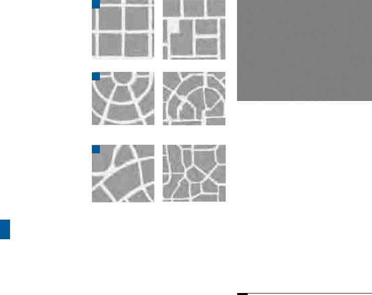
Rectilinear grid.
b
Concentric grids designed to promote access to local centres or public transport routes.
c
Irregular layouts.
Figure 4.8 Variations on the block structure.
4.5.4 Within a block structure, the designer has more freedom to create innovative layouts. The layouts in Fig. 4.8, and variations on them (such as a ‘broken grid’ with the occasional cul-de-sac), are recommended when planning residential and mixed-use neighbourhoods.
Geometric choices and street pattern
4.5.5Straight streets are efficient in the use of land. They maximise connections between places and can better serve the needs of pedestrians who prefer direct routes. However, long, straight streets can also lead to higher speeds. Short and curved or irregular streets contribute to variety and a sense of place, and may also be appropriate where there are
topographical or other site constraints, or where there is a need to introduce some variation
for the sake of interest. However, layouts that use excessive or gratuitous curves should be avoided, as they are less efficient and make access for pedestrians and cyclists more difficult.
4.5.6Geometricchoicesandstreetpatternshould be based on a thorough understanding of context.
Andrew Cameron, WSP
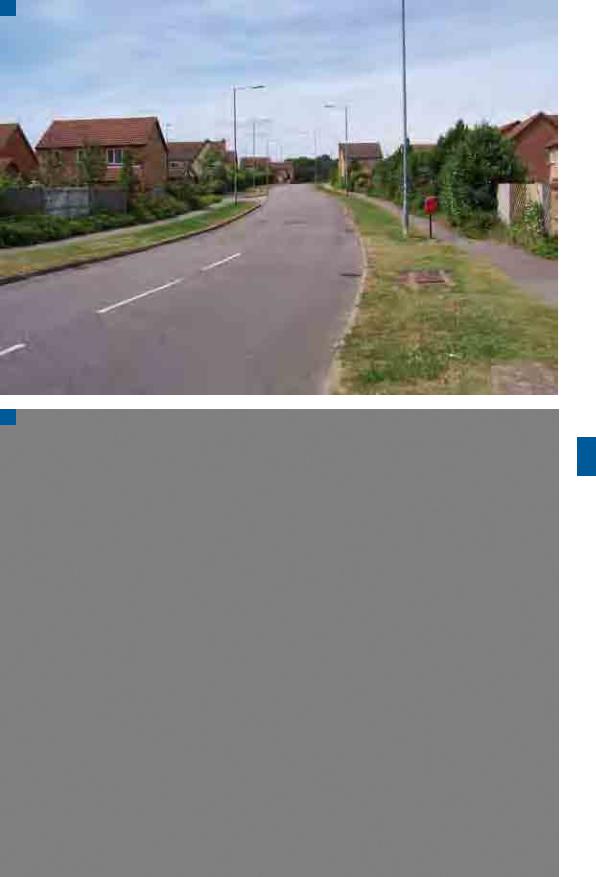
Figure 4.9 A good example of a pedestrian/cycle route at Poundbury, Dorchester. It is short, direct and with good surveillance.
4.5.7 Cul-de-sacs may be required because of topography, boundary or other constraints. Cul-de-sacs can also be useful in keeping motortraffic levels low in a particular area, but any through connections for pedestrians and cyclists should be well overlooked with active frontages. Cul-de-sacs can also provide the best solution for developing awkward sites where through routes are not practical (Fig. 4.9). Caution must, however, be exercised when planning for cul- de-sacs, as they may concentrate traffic impact on a small number of dwellings, require turning heads that are wasteful in land terms and lead to additional vehicle travel and emissions, particularly by service vehicles.
4.6Crime prevention
4.6.1The layout of a residential area can have a significant impact on crime against property (homes and cars) and pedestrians. Section 17 of the Crime and Disorder Act 1998,7 requires local authorities to exercise their function with due regard to the likely effect on crime and disorder.To ensure that crime prevention considerations are taken into account in the design of layouts, it is important to consult police architectural liaison officers and crime prevention officers, as advised in Safer Places.8
4.6.2To ensure that crime prevention is properly taken into account, it is important that the way in which permeability is provided is given careful consideration. High permeability is conducive to walking and cycling, but can lead to problems of anti-social behaviour if it is only achieved by providing routes that are poorly overlooked, such as rear alleyways.
46 |
Manual for Streets |

9Welsh Assembly Government (2002).
Technical Advice Note 12: Design. Cardiff: NAfW. Chapter 5, Design Issues.
4.6.3 Safer Places highlights the following principles for reducing the likelihood of crime in residential areas (Wales: also refer to Technical Advice Note (TAN) 129):
•the desire for connectivity should not compromise the ability of householders to exert ownership over private or communal ‘defensible space’;
•access to the rear of dwellings from public spaces, including alleys, should be avoided
– a block layout, with gardens in the middle, is a good way of ensuring this;
•cars, cyclists and pedestrians should be kept together if the route is over any significant length – there should be a presumption against routes serving only pedestrians and/or cyclists away from the road unless they are wide, open, short and overlooked;
•routes should lead directly to where people want to go;
•all routes should be necessary, serving a defined function;
•cars are less prone to damage or theft if parked in-curtilage (but see Chapter 8). If cars cannot be parked in-curtilage, they should ideally be parked on the street in view of the home. Where parking courts are used, they should be small and have natural surveillance;
•layouts should be designed with regard to existing levels of crime in an area; and
•layouts should provide natural surveillance by ensuring streets are overlooked and well used (Fig. 4.10).
Tim Pharoah, Llewelyn Davies Yeang
Figure 4.10 Active frontage to all streets and to neighbouring open space should be an aim in all developments. Blank walls can be avoided, even on the return at junctions, with specially designed house types.
Manual for Streets |
47 |

4.7Street character types
4.7.1Traditionally, road hierarchies (e.g. district distributor, local distributor, access road, etc.) have been based on traffic capacity. As set out in Chapter 2, street character types in new residential developments should be determined by the relative importance of both their place and movement functions.
4.7.2Examples of the more descriptive terminology that should now be used to define street character types are
• high street;
• main street;
•shopping street;
•mixed-use street;
•avenue;
•boulevard;
•mews;
•lane;
•courtyard;
4.7.3 The above list is not exhaustive. Whatever terms are used, it is important that the street character type is well defined, whether in a design code or in some other way. The difference in approach is illustrated by
Figs 4.11 and 4.12.
a |
|
b |
|
English Partnerships, EDAW and Alan Baxter & Associates |
English Partnerships, EDAW and Alan Baxter & Associates |
|
Figure 4.11 Alternative proposals for a development: (a) is highways-led; while (b) is more attuned to pedestrian activity and a sense of place.
48 |
Manual for Streets |
a
Andrew Cameron, WSP
b
Andrew Cameron, WSP
Figure 4.12 (a) Existing development in Upton turns its back on the street; while (b) a later development has a strong presence on the street. The latter was delivered using a collaborative workshop design process and a design code.
Manual for Streets |
49 |