

Drewett_1999_Field_Archaeology
.pdfPOST-FIELDWORK AND FINDS ANALYSIS |
157 |
debris, shells which have been utilized (some after the shellfish has been eaten), and shells that arrived on site in other ways.Asite on a sand bar, for example, will have natural residual shells. Shells may have been collected dead from beaches and brought back as toys or trinkets; others may have been carried onto the site by hermit crabs. Worn or abraded shells should generally be excluded from dietary calculations. In fact shellfish, except perhaps the conch (Strombus gigas) or giant clam (Tridacna gigas) provide surprisingly little in the way of calories, so are unlikely ever to have been a significant contribution to diet except in periods or areas of hardship. Often shellfish are simply an additional luxury, as in the case of oysters in Roman Britain.
The analysis of small shell assemblages involves firstly identification of species, preferably from a comparative reference collection, but otherwise from a range of well illustrated books available for some regions of the world (for example, Humfrey 1975). Minimum numbers of individuals (MNI) can then be calculated in a way similar to bones. Each gastropod has only one apex, while all left valves of bivalves can be counted. It is also possible in some parts of the world to establish the time of year that shells were harvested by counting growth lines. The thicker lines grow in the summer while thin lines indicate winter growth.
Seeds and other plant remains Plants were, and still are, a major form of human food and yet there is a strong bias against their remains surviving in the archaeological record. Plant remains survive only if waterlogged, desiccated or carbonized. Carbonized plant remains are the most common on archaeological sites. The fact that most plants remains survive only if burnt inevitably introduces bias into the archaeological record. Certain plant remains are more likely to get burnt than others. Perhaps the carbonized barley found in a later bronze age pit at Black Patch, East Sussex (Drewett 1982) was being prepared for brewing. Of the 21 kg found in Pit 3, 96 per cent was barley while only 4 per cent was wheat. In fact more wheat could have been grown on the farm, but most was perhaps successfully ground for flour. There is also the problem that some plants produce thousands of small seeds, while others produce few, bigger ones, so simply counting or weighing plant remains may in no way represent the relative importance of different species.
Seeds must, however, first be identified to species level. This is done under a microscope and, as with bones and shells, compared with a reference collection. With small numbers of seeds, results should perhaps only be expressed in terms of presence or absence, but with larger assemblages quantification is generally undertaken by weight or minimum number of individuals. Explanatory text, however, must emphasize that these figures may be strongly biased by a variety of factors and do not necessarily represent real proportions of plants grown and/or consumed.
The other most common plant on archaeological sites are charcoal. This provides both evidence of human use, for example for firewoods, but also gives hints at the local environment. Humans will, however, select woods, so the use of charcoal in environmental reconstruction is limited. Unless large quantities of charcoal are present, it is probably best to identify it to species level (or sometimes only genus) in the same way as for a wood sample (see above) and
158 FIELD ARCHAEOLOGY
then simply express in presence or absence terms. Counting or weighing charcoal is of dubious value, as one burnt apple branch can produce thousands of charcoal fragments while it may in fact not have been the most common species used on site.
Finds analysis: environmental samples
The analysis of environmental samples collected from archaeological sites and their environs requires specialist knowledge, and generally a considerable outlay in terms of time and money. It is always best to involve the environmental archaeologist from the initial planning of the project right through to analysis and final publication. What environmental indicators survive on a particular site depends entirely on its location, whether the soil is acid or alkaline, wet or dry, and its post-depositional history. Rarely do all types of environmental data survive on one site, although they may survive within a varied local environ (Evans 1978).
Pollen analysis Pollen derives from all flowering plants and will generally survive well in any conditions lacking aerobic bacteria. It survives best in peat bogs, but also survives well in many other archaeological contexts, like land surfaces buried under round barrows or other earthworks, damp ditches or pits, and well fills. Samples are usually taken in columns at regular intervals, and immediately sealed to prevent contamination from modern pollen (Fig. 5.12). Each sample, or part of it, is examined under a microscope to extract and identify the pollen present. This is a long, laborious task, particularly as pollen can often be identified only to family or at least genus level rather than to species (Dimbleby 1978).
The pollen grains of each plant are counted and then expressed as a percentage of the total number of grains in the particular sample. These data are then usually illustrated graphically to show variations through the stratigraphic sequence sampled. Although the identification of pollen is essentially a mechanical process, comparing pollen shapes with pollen from known plants, the interpretation of the data requires considerable knowledge of plants and particularly how pollen is dispersed. Wind-dispersed pollen like pine can travel great distances, while insect-dispersed pollen, like lime, is likely to be more local. Some plants are even pollinated by slugs and snails, so their pollen moves only very small distances (Dimbleby 1978).
Land snails Pollen rarely survives well in alkaline conditions, but fortunately in these areas land molluscs do survive well. These are the snails that live in abundance in many environments. When they die, their shells become incorporated into sediments in the landscape and deposits on archaeological sites. There are many species of land snails and many, but not all, have ecological preferences. Some prefer woodland, others short grass, while some can tolerate arable conditions (Evans 1972). Soil samples are taken from sealed deposits and all the land snails are carefully sieved out using fine mesh laboratory sieves (Fig. 8.5). Samples hand-picked on site are of little use, as it is the percentage of different species that is important, not simply

POST-FIELDWORK AND FINDS ANALYSIS |
159 |
Figure 8.5 Extracting land snails in an environmental laboratory.
the presence or absence of particularly big shells. Counting is undertaken under a microscope, for many land snails are extremely small. The counting process is basically the same as for marine mollusca. What is important is how many individuals are present, not how many shell fragments. The minimum number of individuals (MNI) is calculated by counting apexes only, as each shell has only one.
The interpretation of land molluscan counts requires detailed knowledge of the habitats of the species involved and their speed and ability to adapt to changing conditions. The results of the analysis are often presented in absolute frequencies and percentage frequencies of different ecological groups, together with explanatory text.
Soils and sediments The analysis of soils and sediments (soils contain an organic element which can support plant life while sediments are entirely inorganic) can provide considerable information about the environment of a site. The first stage of soil or sediment analysis takes place in the field and involves basic description of colour, texture, consistency and coarse components (Chapter Seven). Far more information can, however, be obtained through laboratory analysis (Cornwall 1958, Limbrey 1975). As with the analysis of all archaeological materials, broad questions will have been formulated at the start of the project, but during the excavation new questions may arise, for example, is this context a buried soil? .
Techniques of soil and sediment analysis can be broadly divided into physical and chemical methods. Physical methods involve either separating deposits into their constituents and

160 FIELD ARCHAEOLOGY
quantifying their size, shape and type, or preparing thin sections of the deposit for study under a microscope. Either way, the aim is to identify elements that may be characteristic of a particular formation process. Rounded particles, for example, may indicate rolling in water, whereas angular particles with limited attrition may indicate colluvial deposits. Mechanical separation of sediments can be undertaken using nests of sieves from, say, 2 mm down to 0.063 mm.
A high percentage of many sediments consists of quartz and other common light (that is, having a specific gravity of less than 2.89) minerals. It is the other heavy minerals that often indicate differences which can help determine the origin of the deposit and how it arrived at the site, so heavy-mineral analysis is often the key physical method applied to sediments. Greater detail of the composition of a soil, and particularly how the various elements present relate to each other, can be obtained by preparing thin sections rather like those prepared for pottery. With soils, however, the sample always has to be consolidated prior to grinding and mounting on a glass slide (Cornwall 1958).
A wide range of optical and other equipment is available for the chemical analysis of soils. However, simply listing chemicals in the soil or a sediment is rarely going to contribute much to the archaeology of a site. Again, specific questions should be asked of specific contexts. For example, is there no burial under this barrow because the pH is too high for the survival of bones, or, does the carbon or phosphate content of this context suggest human activity?
Figure 8.6 Diatom: unicellular algae with environmental preferences.
POST-FIELDWORK AND FINDS ANALYSIS |
161 |
Other environmental analyses Although the study of pollen, land snails, soils and sediments are the most commonly used analyses for determining the natural environment of specific archaeological sites, many other plant and animal remains may be analysed to help reconstruct the past environment of an archaeological site. Some, like diatoms, require particular local conditions, others, like phytoliths, are more widespread. Diatoms are unicellular algae which live, and die, in bodies of water (Fig. 8.6). Different species have different ecological preferences, so as with land snails they can provide a broad picture of the immediate environment. Phytoliths,thesilicaelement ofplant cells,canalsoberecoveredfromarchaeological deposits and add to our environmental knowledge of a site. Finally, identification of small mammal and rodent bones, worm egg cases, mites and insects can fill out the environmental picture or provide detailed insights into specific contexts on an excavation.
CHAPTER NINE
Interpreting the evidence
Interpretation of the evidence revealed through excavation is not something that happens after the site has been dug and the finds have been analysed. It is an on-going process that takes place throughout the project. Having said that, inevitably interpretations change as new information is recovered, both during the excavation and in the post-excavation and analysis phase. At some stage in the project, however, an interpretation or a range of interpretations for the recovered data has to be decided upon. Raw data is just that. Archaeology is the study of the past through the study of material remains, not simply the study of material remains.
How one interprets material remains of the past does, of course, depend very much on one s theoretical perspective. The past has gone; we cannot reconstruct it, we can only present our interpretations of it based on the material evidence recovered. The aim of this chapter is to consider the interpretation of elements of an archaeological site excavated by a field archaeologist. It does not extend into broader archaeological interpretation of culture history or cultural processes. For this level of interpretation a wide and ever-expanding literature is available (for example, Willey and Phillips 1958, Binford 1983, Hodder 1982, and Shanks and Tilley 1987).
Interpreting the site s environment
To understand how a site may have worked in the past requires some knowledge of the environment in which it existed (Vita-Finzi 1978). The environment in the past may have been very different to the environment today. Clearly, large-scale environmental changes, like the movement of ice sheets and rises or falls in sea level, can dramatically change whole landscapes. Equally, very small-scale changes through human or natural agencies can change local landscapes, both during the life of a site and after its desertion.
Much work has been done on large-scale environmental and climatic change, particularly through the study of foraminifera from deep-sea cores (Butzer 1983). These single-celled organisms have environmental preferences, so as sea levels and the associated salinity fluctuate, so do the ranges of species of foraminifera. Changes in the oxygen isotopes in water as a result
162
INTERPRETING THE EVIDENCE |
163 |
of environmental change are also reflected in differences in foraminifera calcium shells. When working on sites of post-glacial date, however, archaeologists are often more involved with the site s local environment.
The area around a site that is perhaps most important for the understanding of the site is the area used by the inhabitants. Defining such an area is naturally fraught with difficulties. Early attempts used ethnographic data to suggest that hunters and foragers generally utilized an area some 10 km in radius from their home-base, while farmers worked closer to home, rarely travelling more than 5 km to work the landscape. Circles were drawn around the site, and resources within the circles calculated, for example the percentage of good arable land (Higgs 1975). It was soon realized, however, that distance was less important than the actual time taken to get to a resource or work area: it takes longer to walk across rough, undulating or densely overgrown land than across level grassland. Circles were modified to produce zones around sites that took two hours to reach (in the case of hunters and foragers) or one hour (in the case of farmers). Although this technique of site catchment analysis gives a good idea of the potential around a site, it is perhaps more important to know what was actually used on-site and the zone of exploitation indicated by real evidence (Flannery 1982).
Having decided upon the area to be considered in determining the local environment, a range of approaches can be brought to bear on the problem of what that environment was like in the past and how it changed through the life of the site. Direct observation of the present local environment is a good starting point. Hills, valleys and the solid geology are unlikely to have changed much in the more recent past. Water sources can however change, with rivers meandering across flood plains and springs drying up through climatic change or even current local water-pumping. The greatest changes will, however, be in the soils, vegetation and local fauna. These are the key areas of investigation when attempting to reconstruct the local environment of a site. Much data may be available from the excavation of the site itself, but more will be available from the wider landscape if suitable deposits can be located.
River alluvium and dry-valley colluvial deposits will provide information about soils formerly on the slopes above the deposits (Fig. 9.1). If calcareous, these deposits may contain land snails which, as we have seen in Chapter Eight, provide a broad ecological picture. For a more detailed picture of the local vegetation, attempts should be made to locate suitable deposits where pollen may survive. Peat is one of the best deposits, but pollen may survive in any anaerobic sediments or buried soils. Ideally a range of studies should be applied to the area to determine both the environment in which the site was constructed, and then changes in the local environment resulting from the use of the site. It should always be remembered that most environments are constantly changing under natural and human pressures, and such changes could affect how the site is used and even, on occasion, be a contributing factor in its change or even final desertion.

164 FIELD ARCHAEOLOGY
Figure 9.1 Sampling river valley alluvium: a major source of local environmental history.
Interpretation of the household and its activity areas
The household, in its many and varied forms, is a fundamental unit in human societies worldwide, so it is an essential element in the interpretation of archaeological data from most domestic sites. Evidence for the household consists of the house itself and evidence for activity in and around the house. The activities may be represented by sets of artefacts and/or features.
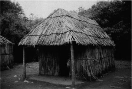
The house may be extrapolated from clusters of postholes, beam slots, masonry walls or robber trenches where walls have been robbed away (Fig. 9.2). Sometimes the structure itself leaves no trace and the site of a house can be determined only through careful plotting of artefact and ecofact distributions (Bradley 1970).Archaeologists generally recover only the plan of the house at ground level, so the nature of the structure above ground level is always open to interpretation. Such interpretations are based on a combination of known architectural parameters (for example, weight and stress of structural elements), available raw materials, ethnographic or surviving architectural analogy, and guesswork. Reconstructions can be built to show that a suggested interpretation could work, but not that it is necessarily the right interpretation (Fig. 9.3). The failure to achieve an agreed interpretation for the superstructure of sunken-feature buildings from early medieval Britain underlines the problem.
The plan of a house is generally laid out with some consideration of functional and social necessities, but it may also be subject to symbolic and cosmic interpretation (Guidoni 1975). Ethnographic data can provide detailed insights into why particular house-plans and orientations

INTERPRETING THE EVIDENCE |
165 |
Figure 9.2 House plans from posthole patterns and wall footings.
are used in a specific context by a particular people at a particular time. The lowland South American Malocas are a good example. These oval houses are orientated on an east west axis with the men s door at the east and the women s door at the west end. The posts supporting the
166 FIELD ARCHAEOLOGY
Figure 9.3 Experimental archaeology: house reconstruction.
roof are mountains, the roof itself represents the sky, the edge of the world is marked by hills represented by the walls. The ridge pole is the path of the sun, and an imaginary river flows through the middle of the house which becomes the river of the dead under the house (HughJones 1985). To apply such mythology outside the geographical and temporal area of the myth would clearly be unacceptable; what it does show, however, is that the interpretation, even of house plans, should perhaps take into consideration more than simply the functional aspects of the house. The same may apply to the location of activity areas. In a Dogan house (Mali), for example, the kitchen represents the head, the main room the trunk, and larders represent limbs. The head is therefore always on the trunk with limbs on either side (Griaule 1938). The location of activity areas may, therefore, also have a symbolic and cosmic element.
The interpretation of a particular area as the site of a particular activity is not always straightforward: some activities leave clear archaeological traces while others do not.Asleeping area may leave little or no trace, while a cooking hearth could leave clear traces. The residues of activities will probably be regularly cleared during the life of a household, and perhaps dumped as middens or into old storage pits. This secondary rubbish indicates the range of activities but not where they took place.
Household activity areas are best interpreted by combining the evidence of features with artefact spreads, and relating these to information gleaned from possible reconstructions of the house itself. Bronze age round houses in Britain, for example, often show discrete spreads of artefacts on their floors. One interpretation of these data is that they show actual areas where final activities took place prior to desertion of the site (Fig. 9.4). The way the round houses were