

Drewett_1999_Field_Archaeology
.pdfDIGGING THE SITE |
107 |
Excavation
The aim of excavation is to identify, define, uncover, date, and by understanding transformation processes interpret each archaeological context on a site. Usually this process is carried out in the reverse order of the site s construction, cutting or deposition. I am using the term context as it is used widely in British archaeology today.A context refers to any discrete archaeological entity on site, and so could refer to a layer, a pit or a posthole. It is often the result of a single action, whether it leaves a positive or a negative record on the site. The cut of a posthole, for example, leaves a negative record (that is, something has been removed) whereas the fill of a posthole leaves a positive record (that is, the content of the posthole has been added to the sequence). Contexts were traditionally known as layers and features in Britain, and these terms are still widely used elsewhere in the world. In the USA the term stratigraphic unit is used. Some archaeologists argue strongly for one term or another, but as these are simply labels of convenience it really does not matter. No prehistoric person said Let s go and make a context today ! For this discussion I will use the term context as it is the shortest.
A context consists both of a discrete archaeological entity, and its interfaces with other contexts (Harris 1979). A specific deposit of soil will be above something, below something (unless the top layer), and beside any number of other deposits. At each of the junctions there is an interface. By isolating interfaces, sequences the stratification of the site can be established. Not all contexts and their interfaces cover the whole site, hence one of the many problems of digging small holes which may, or equally may not, be typical of the stratigraphy of the whole site.
Contexts are basically the result of natural erosion and deposition (Pyddoke 1961) and of human activity operating within the context of these natural processes. The natural process of erosion and deposition is well known on a geologically large scale.All hills are gradually eroding and the resulting erosion products are deposited in low-lying areas like valleys. This process also takes place on the very small scale. The soil dug out of a posthole, if left as a pile after the post is set in the hole, will erode down, mainly through the action of wind and rain. This soil will either wash into any hollows or spread out over a surface. Human activities like pit-digging will cut into lower deposits, creating new contexts: the pit and pile of soil will be used and transformed into the contexts the archaeologist isolates.
A crucial element of excavation is therefore the process of defining contexts. This may be easy or may be extremely difficult. It requires skill and experience.Awall, a hearth, a pit may be fairly easy to isolate, but the eroded pile of soil from a posthole may have simply blended away into adjacent contexts. To define a context one is essentially looking for differences, differences in colour, texture, consistency and coarse components, and the junction or interface of these differences. We will be returning to the description of these four elements when considering the record of contexts in Chapter Seven. Here the importance is simply to define elements of the site that are different.At its very simplest, an area with black soil is different from an area with
108 FIELD ARCHAEOLOGY
red soil is different from an area of red soil with bits of stone in it. The context thus defined is recorded in plan (Chapter Seven) and then decisions have to be made about how to excavate it.
Recurrent types of context and their excavation
One of the most important things to remember when excavating is that people rarely lived on walls, down pits, in postholes or in ditches, and yet excavations are often dominated by these contexts. People lived on surfaces, and much of what they did on surfaces will leave only the slightest trace or none at all. Some surfaces, like the tiled floor of a medieval hall, are relatively easy to isolate and excavate. Other surfaces will include the natural land surface during the period of occupation. These are much more difficult to define and excavate. They may be traceable only through changes in soil chemistry or magnetic susceptibility (Chapter Three), by areas of trampling, or by artefact patterns.
Identification of living surfaces is made more difficult by post-depositional transformation processes (Chapter Two). Layers with low concentrations of artefacts (not middens or rubbish dumps) may represent the artefacts from a living surface that have been worm-sorted down the profile. The pattern of artefacts could still represent the activities on the occupation surface, but be 20 cm or so below the surface that was actually lived on (Darwin 1881). Trampling on that surface may have been worm-sorted out of existence. The surface as such will survive only if rapidly buried. Surfaces can really only be excavated in plan, hence the desirability of openarea excavation.
Black Patch (Drewett 1982), the bronze-age site in East Sussex, is an example of how careful plotting of worm-sorted artefacts made it possible to suggest where specific activities likeweaving,leather-,wood-,andbone-working,andcookingtookplace(Fig.6.4).Theexcavation technique employed was to grid the area under excavation into one-metre squares. These were all excavated at the same rate, with every artefact and ecofact left in situ.At the end of each day all objects were recorded directly onto field plans, lifted and bagged by grid square and, in the case of specific objects like bronze pieces, by two-dimensional co-ordinates (see Chapter Seven). Living surfaces will often merge into the surrounding landscape, making definition of extent almost impossible. Somewhat arbitrary decisions about extent may have to be made.
Some types of archaeological context are much easier to define than surfaces. These include recurrent contexts like pits, postholes, ditches and walls. These are the contexts traditionally and often still known as features . Pits include a wide variety of holes dug from the living surface into underlying layers, and often into bedrock. Rarely are they actually dug as rubbish pits, although this may be their final use. Pits were dug for all sorts of reasons including to store grain or other foodstuffs, for water storage, as quarry pits, cesspits, cooking pits, earth ovens, manure stores, or for ritual functions. The purpose of excavating a pit is, like the excavation of the whole site, to establish sequence and event. When was the pit dug, used, abandoned and filled in? How was the pit dug, what was its size, shape, and lining, and what events took place during its life? Then, how does it relate to other pits and contexts on the site?

DIGGING THE SITE |
109 |
Figure 6.4 Excavating a hut floor by one-metre squares.
To establish sequence, pits are often half-sectioned. The top edge of the pit is carefully defined and then divided into two halves with string and nails. Some excavators orientate all section lines north south. Although this looks neat on the plan, it has no real advantage and orientation in relation to sunlight, both for photography and drawing, is worth consideration: drawing pit-sections is extremely difficult when half is in sun and half in shade. One half of the pit is then excavated following natural stratigraphic layers (Fig. 6.5). Arbitrary spits should be dug only if no natural layers can be determined. The surface of each new layer should be carefully excavated in plan. Even if you consider the deposit to be just domestic rubbish thrown in an old storage pit, there may be structure within the rubbish, or specifically placed offerings. What we see as rubbish today may have had all sorts of meanings and taboos in the past. The edges and bottoms of pits should be treated with extra care as they may provide information concerning the primary function of the pit.
Having dug one half of the pit it should be recorded as part of the written, photographic and drawn record (Chapter Seven) and then the other half carefully removed in the same way. Pits, because of their depth, often have good preservation of carbonized organic material, so are often subjected to water flotation. Remember, however, that the contents of pits usually comprise secondary rubbish and tell you about activities elsewhere on the site, generally not about activities taking place in the pit itself (except, of course, the activity of rubbish disposal). An alternative way to excavate a pit is in plan. The top of each natural stratigraphic layer is carefully cleared and levels taken. From these levels sections can be reconstructed through the deposits on any line. Excavating in plan has the advantage of allowing whole surfaces as well as any
110 FIELD ARCHAEOLOGY
Figure 6.5 Half-sectioning a pit.
Figure 6.6 Sectioning intercutting pits.
activities (like votive depositions) to be viewed. In a half-sectioned pit these deposits have to be dug and recorded in two halves.
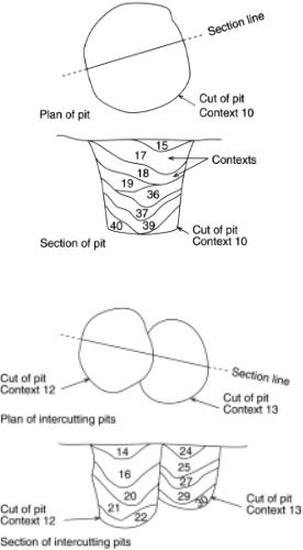
If any pit cuts through another, it may be possible to establish a sequence of pit-digging. Again this can be done in plan, but the relationship is usually defined in section. To do this the edges of both pits should be defined in plan and then the section line laid out through both pits rather than treating each as a separate pit (Fig. 6.6). If you are lucky you may see how one pit cut through the fill of the other. Roots, worm-sorting or burrowing animals may, however, have removed this evidence, so if there is doubt record the sequence as doubtful. The relationship may be resolved when other factors, like datable artefacts, are taken into consideration.

DIGGING THE SITE |
111 |
Figure 6.7 Half-sectioning a posthole.
Timber posts set into the ground were, and in many areas still are, used for a wide variety of constructions, from the greatAmerindian round houses to simple drying racks. The ability to recognize, define and excavate postholes is essential on most excavations. There are three main elements to these contexts. Firstly a hole dug into the ground, often known as the post-pit although sometimes as the posthole . Secondly the post is put into the hole and then packed around with soil or rocks: the post-packing . If left to rot or pulled out, the post may leave an imprint in the packing. This is variously known as the post mould , post pipe , or post socket , or sometimes this element on its own is known as the posthole . For the erection of very large posts there may also be a post ramp cut down into the post pit. Careful excavation of postholes is therefore essential as, firstly, they can be confused with many other holes both humanly-dug or natural, and secondly the size of the post pit may or may not relate directly to the size of the post, and the size of the post is what matters when reconstructing buildings.
The most usual way to excavate a posthole is to half-section it. This is best done when all postholes from an individual structure, like a round house, are visible in plan. Carefully clean the top of the posthole in plan. If you are lucky, the post pipe or mould may be visible, or more usually an erosion cone above the top of the post pipe may be seen (Fig. 6.7). If the position of the original post is visible in plan, then the half-section should be laid out through the post pipe and packing to the edge of the post pit. The half-section is then cut out carefully, keeping all finds from the post packing separate from any from the the post pipe. The section can then be recorded (a written, drawn and photographic record) and the other half removed. If no post pipe is visible in plan, then the posthole could be quadranted, giving two cross-sections, or excavated

112 FIELD ARCHAEOLOGY
Figure 6.8 Problems with half-sectioning and quadranting postholes.
in plan with a section reconstructed from the plans. Usually, however, an intelligent guess is made and a single section is cut through the middle of the hole. This can, however, either miss the post pipe altogether or produce totally erronous evidence (Fig. 6.8).
The dating of postholes is not at all straightforward. The date of objects within a posthole will provide only a terminus post quem date, that is, the posthole is from the same date as the latest object within the hole or later. Clearly, in terms of sequence of deposition, the objects within the packing material will be earlier in date than those in the post pipe. Usually, however, objects within postholes bear little relationship to the date of the hole, especially on multi-period sites. This is hardly surprising. When a posthole is dug, the hole-digger will cut through earlier occupation layers (with their artefact assemblages). The post is then set in
DIGGING THE SITE |
113 |
the hole and either the soil dug out is packed in again, or only the big bits dug out, like potsherds, bones and stone packed in to hold the post steady. A medieval post put in on a site occupied in the neolithic period may therefore contain only neolithic artefacts in its packing.
The post may finally rot or be pulled out. If it rots in situ, fine particles of soil may fill in the void and no artefacts are likely to get into the post pipe. If, however, the post is pulled out, then surface rubbish may fall or be pushed into the hole. The material will provide a terminus ante quem for the removal of the post. The post has to have been removed at the time of the date of the latest object in the post pipe or later.
A safer way to date postholes is to attempt to date the surface from which they were dug. This is rarely easy on shallow sites where postholes are generally not recognized until seen cut into bedrock. This is particularly the case on ploughed sites.Again the surface from which the posthole was dug, if locatable, will provide only a terminus post quem although the layer above the surface will provide a terminus ante quem. Generally, individual postholes are undatable, but fortunately postholes are often part of a larger structure which may be dated either by the plan of the structure, or its relationship to other contexts like floors.
Ditches are, and were in the past, dug for a wide variety of reasons. Massive ditches could defend towns or hillforts. Little ditches or gullies could be dug around individual houses to prevent flooding. Whether big or small, they present the problem that, as linear features, the sequence at one spot may be totally different to the sequence at another.Asingle right-angled cross-section will only give the dimensions of the ditch, its sequence of filling, and possibly recutting, at that point. A section a metre away may give a totally different sequence. To understand fully a ditch sequence, it should ideally be excavated as a series of quadrants so that you end up with sections across the ditch, but also a continuous longitudinal section (Fig. 6.9). This process is, however, time consuming, so it may be better to spend time and resources on understanding what is happening within the ditched enclosure than working out minute sequences of ditch fills. The edges of ditches are usually quite clear if dug into bedrock, but if in doubt it is better to overcut, or even box-section into the adjacent bedrock (Fig. 6.10). This process, although often frowned upon in Britain, is widely used in some parts of the world.
When ditches are seen to cross in plan, it is essential to attempt to work out the sequence of digging as this will be important in working out the development of the site. Sometimes the sequence of cutting can be seen in plan, but if not, sections must be carefully located to provide sections through both ditches, so cuts can be determined (Fig. 6.11). As with pits and postholes, the date of objects within ditches can only provide a terminus ante quem.
Unlike the excavation of pits, postholes and ditches, which involve a cut-and-fill, walls present their own problems.Unless excavating standing structures,walls are generally represented archaeologically either by foundations, or even only by trenches left by stone robbers (robber trenches). It is rare for masonry structures to be built directly on the ground surface, except in

Figure 6.9 Sectioning a length of ditch (M. Redknap and M. Millett for Sussex Archaeological Field Unit).
Figure 6.10 Box-sectioning a ditch.

DIGGING THE SITE |
115 |
Figure 6.11 Sectioning intercutting ditches.
the case of simple low-walled buildings. Usually walls are built on something solid like bedrock, or footings set in a foundation trench. Foundation trenches can be used in two ways. Either a trench the width of the wall footings is dug and filled with footings, or the trench is dug wider than the footings, the footings built, and the remainder of the trench backfilled. Objects found in the foundation trench are likely to pre-date the wall by years or even centuries, so again provide only a terminus ante quem. Every effort must be made to determine the layer from which the foundation trench was cut. The foundation trench has to be the date of that layer or later, but earlier than the date of the layer sealing the foundation trench cut (Fig. 6.12).
Sequences of construction of wall footings can sometimes be determined by looking at points where bits of wall meet. A straight join where one wall butts against another usually

116 FIELD ARCHAEOLOGY
Figure 6.12 Excavation and dating of wall footings.
Figure 6.13 Excavation and dating of a robbed wall.
suggests different periods. This can often be confirmed by differences in building material,relative depth of the foundations, and perhaps by differences in the mortar used. If the wall has been robbed completely, it may be possible to trace former walls only by the pattern of robber trenches. When excavating a robber trench, great care should be taken to determine its extent in relation to the original foundation trench (Fig. 6.13). The robber trench is likely to be more or less the actual width of the wall. Masonry buildings should always be excavated in plan with sections at right angles to walls.
The excavation of human burials presents legal, ethical and practical problems to field archaeologists.As mentioned in Chapter Five, the excavation of human remains in England (the position is somewhat different in other parts of the UK) requires a Licence for the Removal of Human Remains under the 1857 BurialAct. In the USAthe NativeAmerican Graves Protection and RepatriationAct 1990 requires human skeletal material to be returned to tribal descendants