

Lecture 1 geography and cultural regions of the u.S.A.
This lecture will describe the land, physical features, and climate of the United States of America, and cover the following items:
the U. S. political geography and political divisions,
origin of states' names,
the U.S. capital and largest cities,
the U.S. politics,
physical geography: major lakes and river systems, U.S. deserts,
climate, environment,
large country with many cultural differences,
cultural regions: the Northeast, the South, the West, the Midwest, the Southwest,
Americanization.
Key Words and Proper Names: adjacent, arid (semi-arid), as of 2013 U.S. Census Bureau estimates, contiguous, converge, county, cultural identity, drainage, drawl, extant political entities, extraction, fossil fuel, freight, gorge, homogenizing influence, intermixing of cultures, level off regional differences, metro area, offshore rig, parish, precipitation, patois, pronounced peculiarities, resentment, reverence for the past, startling, statehood, thrift, tolerance, township, tributary, urban sprawl;
Native American tribes; the Appalachian Mountains, the Adirondacks, the Cordilleran system, the Great Plains, the Interior Highlands, the Interior Plains, the Ozark Plateau, the Intermontane Plateaus, the Laurentian Highlands, the Rocky Mountains; the Great Lakes (Superior, Huron, Michigan, Ontario, and Erie), the St. Lawrence River, the Mississippi-Missouri rivers; the Colorado Desert, the Great Basin, the Mojave Desert, the Sonoran Desert, Sunbelt and Frostbelt;
William Faulkner, Flannery O'Connor, Carson McCullers, Katherine Anne Porter, Robert Penn Warren, Eudora Welty, Tennessee Williams, Thomas Wolfe.
The United States of America is a constitutional federal republic, it comprises 50 states and one federal district, and has several territories in the Caribbean and Pacific.
To call the country as America is not absolutely correct. It is called as the United States, the U.S., the U.S.A., the U. S. of A., America, the States, or (poetically) Columbia depending on a degree of formality
In 1507, German cartographer Martin Waldseemüller made a world map on which he named the lands of the Western Hemisphere as "America" after Amerigo Vespucci, Italian explorer and cartographer.
The country's modern name was first used in the Declaration of Independence, as the "unanimous Declaration of the 13 united States of America" adopted by the "Representatives of the united States of America" on July 4, 1776. The current name was finalized on November 15, 1777, when the Second Continental Congress adopted the Articles of Confederation, they state, "The Stile (name) of this Confederacy shall be 'The United States of America."
The United States of America is the third largest country in the world after Russia and Canada with an area of 9,826,630 (9.8) sq km.
The estimated U.S. population as of July 2014 was 318,662,000 people including an approximate 11.2 million illegal immigrants. So, in size of population it is also the third in the world behind China and India.
The US political geography: The U.S. has the longest undefended ground border in the world with Canada and also shares a long ground border with Mexico.
The country is divided into three distinct sections:
a) the continental United States also known as the lower 48;
b) Alaska, which is physically connected only to Canada,
c) and the archipelago of Hawaii in the central Pacific Ocean.
49 states (all except Hawaii) lie on the North American continent; and 48 of them (all except Alaska) are contiguous and form the continental United States.
Fig.1. 50
American states

The state’s names are: Alabama, Alaska, Arizona, Arkansas, California, Colorado, Connecticut, Delaware, Florida, Georgia, Hawaii, Idaho, Illinois, Indiana, Iowa, Kansas, Kentucky, Louisiana, Maine, Maryland, Massachusetts, Michigan, Minnesota, Mississippi, Missouri, Montana, Nebraska, Nevada, New Hampshire, New Jersey, New Mexico, New York, North Carolina, North Dakota, Ohio, Oklahoma, Oregon, Pennsylvania, Rhode Island, South Carolina, South Dakota, Tennessee, Texas, Utah, Vermont, Virginia, Washington, West Virginia, Wisconsin, Wyoming.
As said above, the U.S. also holds several other territories, districts and possessions, first of all, the federal district called the District of Columbia, which is the nation’s capital, and several overseas areas, the most significant of which are Puerto Rico, American Samoa, Guam, Northern Mariana Islands, and the United States Virgin Islands. The U.S. Navy has held one military base called Guantanamo at an occupied portion of Guantanamo Bay on Cuba since 1898.
The 50 U.S. states vary widely in size and population (Fig.2). The largest states in area are Alaska with an area of 1.7 ml sq km, followed by Texas, and California. The smallest state is Rhode Island, with an area of 4,002 sq km. The state with the largest population is California (35.8 ml people), followed by Texas, and New York. Only a bit more than 500,000 people live in Wyoming, which is also the least populous state. New Jersey, on the other hand, is the most densely populated state.
Fig.2. The U.S. population density

Interesting to know: State names speak to the circumstances of their creation. We may find:
British names. Southern states on the Atlantic coast originated as British colonies named after British monarchs: Georgia, the Carolinas, Virginia, and Maryland. Some northeastern states, also former British colonies, take their names from places in the British Isles: New Hampshire, New Jersey, and New York.
Native American names. Many states' names are those of Native American tribes or are from Native American languages: Nebraska, Kansas, Massachusetts, Hawaii, Connecticut, Missouri, Idaho, Iowa, Wisconsin, Illinois, Minnesota, the Dakotas, Mississippi, Texas, Utah, and others.
Spanish names. Many states in the southeast and southwest have Spanish names, because they are on territories previously controlled by Spain or Mexico. They include Colorado, New Mexico, Florida, California and Nevada.
French names. Because it was previously a French colony, Louisiana is named after the Louis XIV (King of France at the time).
Washington, D.C., or the District of Columbia (also known as the Nation's Capital; the District; and, historically, the Federal City) is the capital city and administrative district of the U.S.A.
Washington, D.C. is a part of the Baltimore-Washington Metropolitan Area, which includes parts of Maryland, Virginia, and West Virginia. It should not be confused with the U.S. state of Washington, located in the Pacific Northwest.
The District of Columbia is a federal district. As specified by the U.S. Constitution, the District is ruled by the U.S. Congress, though it is unrepresented in that body. The population of the District of Columbia is more than 5 mln people.
The centers of all three branches of the U.S. federal government are situated in Washington, D.C., as well as the headquarters of most federal agencies. Washington also serves as the headquarters for the World Bank, the International Monetary Fund, and the Organization of American States, and other international (and national) institutions. Washington is also the site of numerous national landmarks, museums, and is a popular destination for tourists.
Largest cities: The U.S. has dozens of major cities, including several important global cities such as New York City, Los Angeles, and Chicago. The figures expressed below are for populations within 10 city limits (as of 2013 U.S. Census Bureau estimates).
|
Rank City 1. New York City 2. Los Angeles 3. Chicago 4. Dallas 5. Houston 6. Philadelphia 7. Washington, D.C. 8. Miami 9. Atlanta 10. Boston 11. San Francisco
|
Population 19, 949,502 13,131,431 9,537,289 6,810,913 6,313,158 6,034,678 5,949,859 5,828,191 5,522,942 4,684,299 4,516,276
|
Region Northeast West Midwest South South Northeast Northeast South South Northeast West
|
Extensive areas of urban sprawl exist in larger metropolitan areas such as Los Angeles, California; Chicago, Illinois; and New York City.
The U.S. politics: The states are generally divided into smaller administrative regions, including counties, cities and townships, with the exception of Louisiana, where counties are called parishes, and incorporate cities, villages, towns. Altogether, there are an estimated 85,000 extant political entities in the U.S. including counties, municipalities, townships, school districts, and special districts.
The U.S. politics is represented by 50 state governments plus the government of the District of Columbia, and further down the ladder are still smaller units that govern counties, cities, towns, boroughs and villages.
Like the national government, state governments have three branches: executive, legislative, and judicial; these are roughly equivalent in function and scope to their national counterparts. The chief executive of a state is the governor, elected by popular vote typically for a four-year term (although in a few states the term is two years).
All states have a bicameral legislature, the upper house is usually called the Senate and the lower house is called the House of Representatives, the House of Delegates, or the General Assembly, except for Nebraska, which has a unicameral legislature.
There are three general types of city government: the mayor-council, the commission, and the council-manager. These are the pure forms; many cities have developed a combination of two or three of them. Almost all city governments have some kind of central council, elected by the voters, an executive officer or mayor, assisted by various department heads, to manage the city’s affairs, a judge as well as a sheriff to provide law enforcement services.
51st state: The phrase 51st state refers to the territories considered candidates for addition to the 50 states of the country. The District of Columbia is widely recognized to be one of the most likely candidates for statehood. Currently Puerto Rico claims its statehood.
At the same time the phrase 51st state is often used in a humorous or even negative context referring to associates, which act based on American influences, such as Israel, Canada or the United Kingdom. This term also signifies excessive negative American influence. In Europe, people who believe their local or national culture has become too Americanized sometimes use the term “51st state” in critical reference to their respective countries and governments.
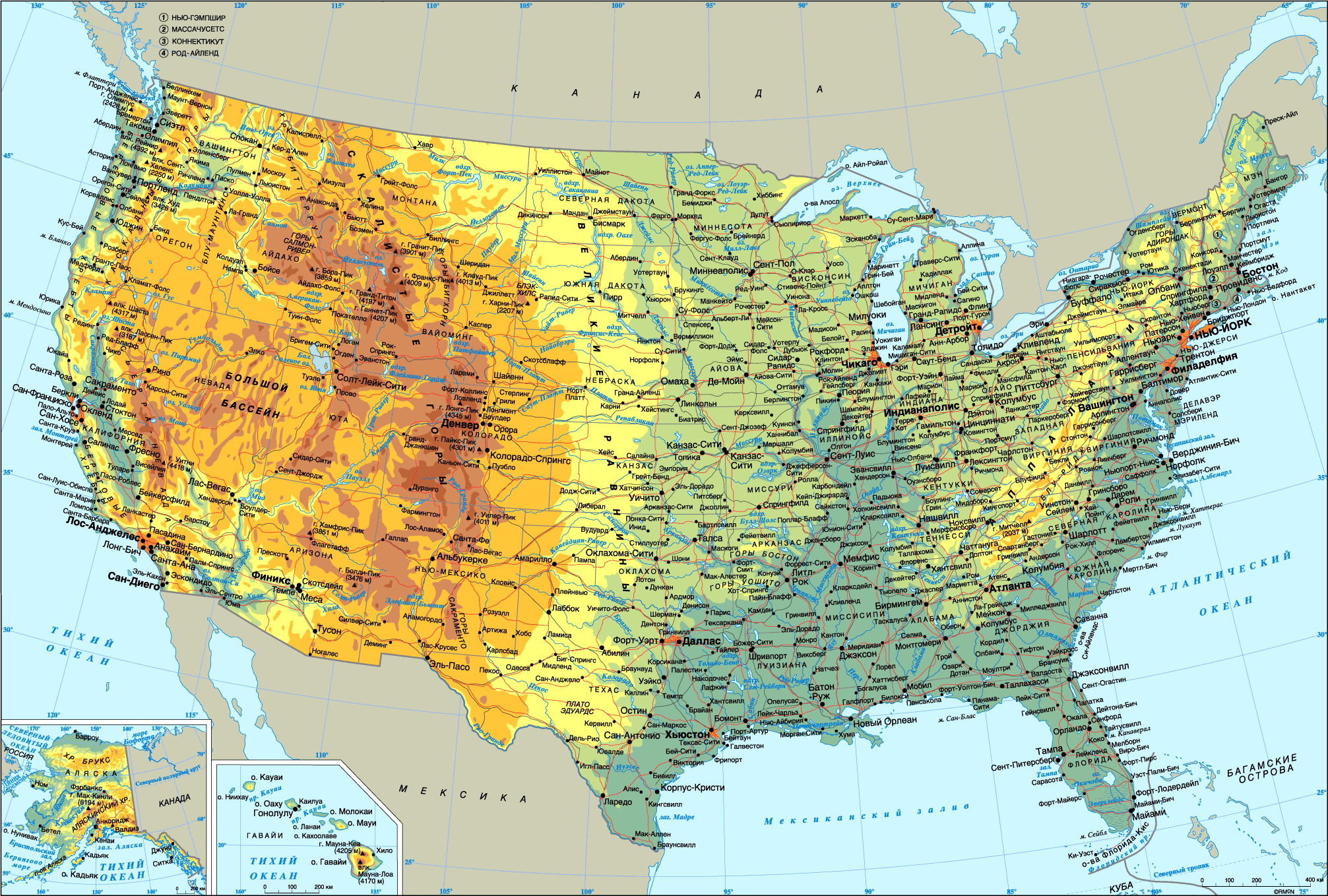
Physical geography: The geography of the U.S. varies across its immense area from temperate forestland to deserts and rain forests, Alaska’s tundra and the volcanic, tropical islands of Hawaii.
Within the continental U.S., 8 there are distinct physiographic divisions. They are the:
Laurentian Highlands – It is a part of the Canadian Shield that extends into the northern U.S. Great Lakes area.
Atlantic Plains – these are coastal regions of the eastern and southern parts including the continental shelf, the Atlantic Coast and the Gulf Coast.
Appalachian Highlands - lying on the eastern side of the U.S., it includes the Appalachian Mountains, Adirondacks and New England province.
Interior Plains – this part of the interior continental U.S. includes much of what is called the Great Plains.
Interior Highlands – It is also a part of the interior continental U.S. and includes the Ozark Plateau.
Rocky Mountain System – It is one branch of the Cordilleran system lying far inland in the western states.
Intermountain Plateaus - it is a system of plateaus, basins, ranges and gorges between the Rocky and Pacific Mountain Systems. It is the setting for the Grand Canyon, the Great Basin and Death Valley.
Pacific Mountain System – these are coastal mountain ranges and features in the west coast of the U.S.
Fig.3. The U.S.A. physical geography
Major lakes and river systems: All the waters east of the Rockies finally reach the Atlantic; all the waters to the west of the Rockies finally arrive at the Pacific. For this reason the Rocky Mountains are known as the Continental Divide.
Two enormous drainage systems dominate the U.S. landscape: the Great Lakes-St. Lawrence River and the Mississippi-Missouri rivers drainage areas. More than 75% of the freight transported along U.S. inland waterways moves on these waterways.
Here, comes the list of the major 11 rivers of the USA and their length in km.
Name km
Mississippi-Missouri-Red Rock 5,970,371
Mississippi 3,770,234
Missouri 3,725,232
Yukon 3,190,198
Rio Grande 3,050,190
Arkansas 2,350,146
Colorado 2,330,145
Columbia 2,000,124
Snake 1,670,104
Ohio 1,579,981
The Great Lakes-St. Lawrence River system serves the northern reaches of the country, from the Midwest to the eastern seaboard. The St. Lawrence Seaway, an extensive network of waterways and locks, allows ship traffic to pass between the Great Lakes (Superior, Huron, Michigan, Ontario, and Erie), and the Atlantic Ocean.
The Mississippi-Missouri River drainage system covers much of the central U.S. This huge system also includes the Ohio River, and the Tennessee River.
The Mississippi is one of the world's great continental rivers. The waters of the Mississippi are gathered from 2/3ds of the U.S. Together with the Missouri River (its chief western branch), the Mississippi flows from its northern sources in the Rocky Mountains to the Gulf of Mexico and is one of the longest water courses known. The Mississippi has been called the “father of waters.”
The two great rivers of the Pacific side are the Colorado and the Columbia. In the dry western country, both rivers are important and necessary sources of life.
The Rio Grande is the foremost river of the Southwest. It forms a natural boundary between Mexico and the U.S.; together, the two governments have built irrigation and flood control projects of mutual benefits. The Yukon is the largest river in Alaska, it and its tributaries make the rugged interior regions of Alaska accessible.
The Central Valley of California depends on irrigation networks linked to the Sacramento and San Joaquin rivers.
U.S. deserts: The Great Basin is an arid area in the western U.S. It includes most of Nevada and portions of Utah, Oregon, Idaho, and California and forms a triangle, widest at the north, with an area of 544,000 sq km. The basin is an area of interior drainage, that is, its waterways drain into desert flats, not into the sea.
The Mojave Desert is an arid region in southern California, part of the Great Basin. It has an area of 52,000 sq km. The Colorado Desert is adjacent.
The Sonoran Desert is an arid region lying primarily in southwestern Arizona, southeastern California, and northwestern Mexico. It covers about 310,799 sq km. The Sonoran Desert accounts for only 20% of Arizona’s land area, but more than 80% of the state’s population lives there, mainly in the rapidly growing areas of Phoenix and Tucson. The desert supports numerous Native American reservations and U.S. military bases and air force. Large portions of the desert are preserved as parkland.
Climate: The climate varies along with the landscape, from tropical in Hawaii and southern Florida to tundra in Alaska and atop some of the highest mountains.
Most of the North and East experience a temperate continental climate, with warm summers and cold winters. Most of the American South experiences a subtropical humid climate with mild winters and long, hot, humid summers. Rainfall decreases markedly from the humid forests of the Eastern Great Plains to the semiarid short grass prairies on the High Plains near the Rocky Mountains. Arid deserts extend through the lowlands and valleys of the American Southwest from Texas to California and throughout much of Nevada. Some parts of the American West, including San Francisco, California, have a Mediterranean climate. Rain forests line the windward mountains of the Pacific Northwest from Oregon to Alaska.
Traditionally the 48 contiguous states are divided into 2 broad patterns of continental climate: the humid East and the arid West. The dividing line is 100 degrees west longitude, extending through the Great Plains from Texas to North Dakota.
Extreme weather is not uncommon — the states bordering the Gulf of Mexico are prone to hurricanes, and most of the world's tornadoes occur within the country, mainly in the Midwest's Tornado Alley.
Different climatic zones create a terrific diversity of the vegetation.
The U. S. has within its borders substantial mineral deposits. America leads the world in the production of phosphate, an important ingredient in fertilizers, and ranks second in gold, silver, copper, lead, natural gas, and coal. Petroleum production is third in the world, after Russia and Saudi Arabia. The U.S. huge fields of natural gas and oil are concentrated in the mid-continent fields of Texas and Oklahoma, the Gulf Coast region of Texas and Louisiana, and the North Slope of Alaska. President B. Obama promised that by 2015 the U.S. would have taken the world leadership in the export of oil. Important minerals mined in the U.S. include gold, copper, iron ore, zinc, magnesium, lead, silver, coal, molybdenum, uranium, bauxite, mercury, nickel, potash, tungsten, natural gas, timber.
Environment issues: As the U.S. economy developed, the natural environment changed. Nowadays sewage and industrial waste pollute rivers and coastal waters, particularly in the heavily industrialized Midwest and Northeast. Acid rains are quite common there. The environmental contamination from American gigantic industrial enterprises contributes to the deterioration of the ozone gas layer in the earth’s atmosphere and global warming.
Oil spills from offshore oil drilling rigs pollute beaches and wetlands along the Gulf Coast. The BP Deepwater Horizon oil spill in the Gulf of Mexico that began in April 2010 became the largest peacetime oil disaster in history. There have also been problems in the nuclear energy industry. An accident at the Three Mile Island nuclear facility in Pennsylvania in 1979 released small amounts of radioactive gas into the atmosphere.
Large country with many differences: The U.S. is a spacious country of varying terrains and climates. Roughly it can be divided into 4 main cultural regions — the Northeast, the South, the Midwest, the West, and Southwest often treated together.
Interesting to know: The Northeast consists of New England: Connecticut, Maine, Massachusetts, New Hampshire, Rhode Island, Vermont; and Mid-Atlantic states :Delaware, Maryland, New Jersey, New York, Pennsylvania, Washington D.C. The South consists of Alabama, Arkansas, Florida, Georgia, Kentucky, Louisiana, Mississippi, North Carolina, South Carolina, Tennessee, Virginia, West Virginia. The Midwest consists of Illinois, Indiana, Iowa, Kansas, Michigan, Minnesota, Missouri, Nebraska, North Dakota, Ohio, South Dakota, Wisconsin. The Southwest consists of Arizona, New Mexico, Oklahoma, and Texas. The West consists of Alaska, Colorado, California, Hawaii, Idaho, Montana, Nevada, Oregon, Utah, Washington, and Wyoming.
Each of these regions maintains a certain degree of cultural identity. People within a region generally share common values, economic concerns, and a certain relationship to the land, and they are usually identified with the history and traditions of their region.
But today, we are witnessing the gradual convergence of these regional identities as a result of globalization. The mobility of people and the spread of pop culture through television and other mass media have greatly advanced this convergence.
However, some regional differences are noticeable. E.g., the food Americans eat. Most of it is standard wherever you go. A person can buy packages of frozen peas bearing the same label in Idaho, Missouri, and Virginia. Cereals, candy bars, and many other items also come in identical packages from Alaska to Florida. Generally, the quality of fresh fruits and vegetables does not vary much from one state to the next. On the other hand, it would be unusual to be served hush puppies (a kind of fried dough) or grits (boiled and ground corn prepared in a variety of ways) in Massachusetts or Illinois, but normal to get them in Georgia.
American speech also often differs according to what part of the country you are in. Southerners tend to speak slowly, in what is referred to as a “Southern drawl.” Midwesterners use “flat” (as in bad or cat), and the New York City features a number of Yiddish words (schlep, nosh, nebbish) contributed by the city’s large Jewish population.
Among differences there are also regional attitudes and outlooks, e.g., the attention paid to foreign events in newspapers. In the East, where people look out across the Atlantic Ocean, papers tend to show greatest concern with what is happening in Europe, the Middle East, Africa, and Western Asia. On the West Coast, however, news editors give more attention to events in East Asia and Australia. To understand regional differences, let’s take a closer look at each cultural region.
The Northeast: The Northeast, comprising the New England and Mid-Atlantic states, has traditionally been at the cradle of the nation’s economic and social progress. The Northeast is more urban, more industrial, and more culturally sophisticated. A sense of cultural superiority sets Northeasterners apart from others.
During the 19th – 20th centuries and well into this century, the Northeast produced most of the country’s writers, artists, and scholars. New England’s colleges and universities are known all over the country for their high academic standards. Harvard is widely considered the best business school in the U.S. The Massachusetts Institute of Technology (M.I.T.) surpasses all others in economics and the practical sciences.
New England does not possess rich farmland or a mild climate. Yet it played a dominant role in the U.S. development. Between the 17th - 19th centuries, New England was the country’s cultural and economic center. New Englanders were engaged in shipbuilding, fishing, and trade, in manufacturing such goods as clothing, rifles, and clocks. Most of the money to run these businesses came from Boston, which was the financial heart of the nation. New England also supported a vibrant cultural life. New Englanders often describe themselves as thrifty, reserved, and dedicated to hard work, qualities they inherited from their Puritan forefathers.
The economic and cultural dominance of New England gradually reduced after WWII. In the 20th century, most of New England’s traditional industries were relocated to the South and West or foreign countries where goods could be made much cheaper. Many factories and mills were closed. As a result of this outsourcing, in many factory towns skilled workers were left without jobs. However, now some parts of New England are experiencing economic recovery thanks to the development of microelectronics and computer industries. New high-tech industries are boosting foreign investment and employment.
If New England provided the brains and dollars for 19th-century American expansion, the Middle Atlantic states provided the muscle. The region’s largest states, New York and Pennsylvania, became centers of heavy industry (iron, glass, and steel).
Like New England, the Middle Atlantic region has much of its heavy industry relocated elsewhere. Other industries, such as drug manufacturing and communications, have taken up the slack.
The South: The South is perhaps the most distinctive and colorful American region. Here the regional identity is most pronounced. The peculiarities of Southern history played an important role in shaping the region’s character. The South was originally settled by English Protestants who came for profitable farming opportunities. Some farmers, capitalizing on tobacco and cotton crops, became very prosperous. They established large plantations with African slaves working there. And though the system of slavery was regarded in the Northeast as unjust, Southern slave owners defended it as an economic necessity which led to the division of the nation and the Civil War of 1861-65 that was the most bloody war in American history. The war devastated the South socially and economically and at the same time gave the South its unmistakable identity. The Civil War experience helps explain why Southerners have developed respect for the past and a resistance to changes, and why the South is different from the rest of the country.
The South differs from other regions in a number of ways. Southerners are more conservative, more religious, and more violent than the rest of the country. Because fewer immigrants were attracted to the less industrialized Southern states, Southerners are the most “native” of any region. Southerners tend to be more respectful of social rank and have strong ties to hometown and family. Even today, Southerners tend to have less schooling and higher illiteracy rates than people from other regions, and pockets of poverty are scattered throughout the Southern states.
Americans of other regions are quick to recognize a Southerner by his/her dialect. Southern speech tends to be much slower and more musical. The Southern dialect characteristically uses more diphthongs: a one-syllable word such as yes is spoken in the South as two syllables, ya-es. In addition, Southerners say “you all” instead of “you” as the second person plural.
The South is also known for its music. In the time of slavery, black Americans created a new folk music, the Negro spiritual. Later forms of black music which began in the South are blues and jazz. Most American country music has a Southern background.
The South has been one of the most outstanding literary regions in the 20th century. Novelists such as William Faulkner, Robert Penn Warren, Thomas Wolfe, Katherine Anne Porter, Tennessee Williams, and Flannery O'Connor addressed themes of the Southern experience such as nostalgia for the rural Southern past.
Today, the South is a manufacturing region, and high-rise buildings crowd the skylines of such cities as Atlanta and Little Rock, Arkansas. Owing to its mild weather, Florida has become a Mecca for retirees from other U.S. regions and from Canada. It is a place for newly-weds and nearly-deads.
The West: Americans have long regarded the West as the last frontier.
The West is a region of scenic beauty on a grand scale. Mountain ranges are the sources of startling contrasts. To the west of the peaks, winds from the Pacific Ocean carry enough moisture to keep the land well-watered. To the east, the land is very dry.
The West is marked by cultural diversity and competing interests. Beginning with the 1980’s, large numbers of Asians settled in California, mainly around Los Angeles. Los Angeles — and Southern California as a whole — has large Mexican-American population.
Mormon-settled Utah has little in common with Mexican-influenced California. Montana ranchers have different needs and different outlooks from the people of Washington or California. Alaska is a vast land of few, but hardy, people and great stretches of wilderness protected in national parks and wildlife refuges. Hawaii is the only state in which Asian Americans outnumber residents of European stock.
California has some of the richest farmland in the country, and, along with Oregon and Washington in the rainy Northwest, does not share the rest of the West’s concern over the scarcity of water. California is densely populated and highly industrial. By combining the nation’s highest concentration of high-tech industries with the greatest percentage of service industries, California’s progressive economy is a trend-setter for the rest of the U.S.
Western cities are known for their tolerance. Perhaps because so many Westerners have moved there from other regions to make a new start; as a rule, interpersonal relations are marked by a live-and-let-live attitude.
The Western economy is varied. Western life is dominated by resources. Although water is scarce in the Mountain West, the region is rich in uranium, coal, crude oil, oil shale (сланцы), and other mineral deposits.
The population of the West rapidly increases, but supplies of water are limited, as a result the West is already experiencing physical limits to growth. While generalizations about the West are difficult to make, the region shares concerns that differ the region from the rest of the country. Westerners are united in their long-standing hostility toward Washington (D.C.) and Eastern federal bureaucrats. Westerners feel government policies fail to address the vital concerns unique to their region. Particularly distressing to Westerners is their lack of control over Western land and resources owned and administered by the federal government. Western states’ troubles with water scarcity and government-owned land seem to matter little to the rest of the country. Westerners like to think of themselves as independent, self-sufficient, and close to the land, but they feel they cannot control their own destiny while Washington controls their land.
The Midwest: While the South and West feel like strangers, the Midwest, by contrast, has long been regarded as typically American. The fertile farmland and abundant resources have allowed agriculture and industry to thrive and to strengthen the Midwesterners’ conviction that people can make something of themselves if they seize opportunities. Class divisions are felt less strongly here than in other regions; the middle class rules.
Midwesterners are seen as commercially-minded, self-sufficient, unsophisticated, and pragmatic.
Midwesterners are also praised as being open, friendly, and straightforward. Their politics tend to be cautious, but the caution is sometimes mixed with protest. The Midwest gave birth to the Republican Party which was formed in 1854 to oppose the spread of slavery into new states. The region also gave birth to the Progressive Movement, aimed at making the local and federal governments less corrupt and more receptive to the will of the people.
Because of their geographic location, many Midwesterners have been strong adherents of isolationism, the belief that Americans should not concern themselves with foreign wars and problems. The Midwest’s position in the middle of the continent, far removed from the east and west coasts, has encouraged Midwesterners to direct their concerns to their own domestic affairs, avoiding matters of wider interest.
The Midwest is a cultural crossroads. Starting in the early 1800’s easterners moved there in search of better farmland, Germans and Dutch - to eastern Missouri, Swedes and Norwegians - to Wisconsin and Minnesota.
Interesting to know: The Plain People create a very colorful cultural group and retain many of their traditions, including their language, which is a blending of several German dialects. The family is still the main social and economic unit, with the church next in importance. Traditional groups, such as the Amish and Mennonites, dress in plain black or brown homespun clothing. These groups have resisted such modern conveniences as automobiles, televisions, and telephones. They are known for their hard work, thrift, and orderliness — qualities reflected in their well-tended farms.
The Midwest is known as a region of small towns and huge tracts of farmland where more than half the nation’s wheat and oats are raised. It is the nation’s “breadbasket.” The region’s fertile soil made it possible for farmers to produce abundant harvests of cereal crops such as wheat, oats, and corn.
Most of the Midwest is flat. The Mississippi River has acted as a regional lifeline, moving settlers to new homes and foodstuffs to market. The river inspired two classic American books, both written by a native Missourian, Samuel Clemens, who took the pseudonym Mark Twain “Life on the Mississippi and Adventures of Huckleberry Finn.”
Dominating the region’s commerce and industry is Chicago, the nation’s third largest city. This major Great Lakes port is a connecting point for rail lines and air traffic to other parts of the U.S. and the world.
The Southwest: The Southwest is often described separately from the Midwest, the West and the South as it differs from them in weather (drier), population (less dense), and ethnicity (strong Spanish-American and Native-American components).
Outside the cities, the region is a land of open spaces, much of which is desert. The magnificent Grand Canyon is located in this region, as is Monument Valley.
Parts of the Southwest once belonged to Mexico. The U.S. obtained this land following the Mexican-American War of 1846-48. Its Mexican heritage continues to exert a strong influence on the region, which is a convenient place to settle for immigrants (legal or illegal) from farther south. A lot of U.S. retirees prefer to live in Arizona.
The four Southwestern states are the homes of numerous Indian reservations.
Population growth in the hot, arid Southwest has depended on two human artifacts: the dam and the air conditioner. Dams on the Colorado and other rivers and aqueducts such as those of the Central Arizona Project have brought water to once-small towns such as Las Vegas, Nevada, Phoenix, Arizona, and Albuquerque, New Mexico, allowing them to become metropolises.
Houston is a center of space research and modern technologies.
Las Vegas is known as one of the world’s centers for gambling, while Santa Fe, New Mexico, is famous as a center for the arts, especially painting, sculpture, and opera.
Americanization: As it was said at the beginning, the distinctiveness of the Northeast, the South, the West, and the Midwest is disappearing. The regions are becoming ever more alike due to the homogenizing influence of mass media and regional convergence towards national socioeconomic norms. Interstate high-ways and communication lines and television are among the basic contributors to this regional convergence.
Americans’ mobility has also played an important part in leveling off regional differences. Americans have always been on the move in pursuit of opportunity. Steady movements from farm to city, east to west, and south to north brought about an intermixing of cultures. This process of Americanization has been accelerated by new migration trends.
Between the 1950’s and 70’s poorer, less populous areas in the South and West experienced tremendous growth as people and businesses moved out of the historically dominant Northeast and Midwest in search of new opportunities in warmer climates. The new migration brought economic prosperity to the warm “Sunbelt” while economic stagnation occurred in the “Frostbelt or Rustbelt.”
The Sunbelt: The attractions of the Sunbelt were numerous. Many older couples moved to the South in order to enjoy retirement in a warmer environment. Others moved to escape problems of urban crime, overcrowding, high taxes, and expensive housing. Most people moved for better employment opportunities. Many corporations relocated to the Sunbelt because of the more favorable business conditions: lower wage scales, weak labor unions, and local governments offered a wide variety of incentives, including tax reliefs to attract new industries. During the past few decades the population of the South and Southwest has been growing rapidly while that of the Midwest or Northeast has grown slowly or not at all.
The increase in population moving to the Sunbelt brought an increase in power. The political and social status of the South and Southwest grew. At the end of the 20th century the South and Southwest gained more seats in the House of Representatives at the expense of the North and Midwest.
A clear rise in per capita income in the South and Southwest is an indication that socioeconomic gaps between regions are narrowing. The cultural dominance of the Northeast and Midwest is diminishing as such as Atlanta, Santa Fe, and Los Angeles, are gaining reputations as important cultural centers. The great universities of the Northeast are rivaled by Stanford in California and the Universities of Texas and North Carolina.
The shift in economic strength and status to the Sunbelt does not mean that the Northeast and Midwest are drained of power and promise. Adapting to the needs of the time, many communities of the Northeast are redirecting their economies to accommodate new service-related and high-tech industries.
So now we should speak not about the decline of the Frostbelt, but rather about a steady converging of the regions' economic status as the formerly lagging Sunbelt states catch up.
The Frontier Spirit: One final American region deserves mentioning here. You will not find it on the map. It is in the hearts and minds of Americans. It is not a fixed place but a moving zone, as well as a state of mind. Traditionally, it was thought to be the border between settlements and wilderness known as the frontier. But in real life terms, it means a challenge, something that is difficult to attain.
Numerous present-day American values and attitudes can be traced to the frontier past: self-reliance, resourcefulness, comradeship, a strong sense of equality.