

A Dictionary of Archaeology
.pdfLower Palaeolithic |
700,000 – 100,000 BC |
|
Middle Palaeolithic |
100,000 – 26,000 BC |
|
Upper Palaeolithic |
26,000 – 10,000 BC |
|
Final Palaeolithic (Arkinian) |
10,000 |
– 6000 BC |
Khartoum Mesolithic |
6000 |
– 3500 BC |
Khartoum Neolithic/Cataract |
|
|
Tradition (Gemaian, Qadan |
|
|
and Abkan industries) |
4000 |
– 3000 BC |
A Group (A Horizon) |
3500 |
– 2800 BC |
C Group (C Horizon) |
2300 |
– 1500 BC |
Kerma culture |
2500 |
– 1500 BC |
New Kingdom (Egyptian occupation) |
1540 – 1070 |
BC |
||
Napatan period |
1000 |
– 300 |
BC |
|
25th dynasty (Nubian rule |
|
|
|
|
over Egypt) |
712 |
– 664 |
BC |
|
Meroitic period |
300 BC – AD 350 |
|||
X Group (X Horizon, |
|
|
|
|
Noba, Ballana) |
AD 350 |
– 550 |
||
Christian period |
AD 550 |
– 1500 |
||
Islamic period |
AD 1500 |
– |
|
|
Table 16 Nubia Chronology of Nubia.
Nubia Ancient geographical area which corresponds to the zone between modern Aswan and Khartoum, i.e. northern Sudan and southernmost Egypt. From at least as early as the 4th millennium BC until the Middle Ages Nubia has served as a crucial conduit, through which the raw materials of tropical Africa passed northwards en route for the civilizations of the Mediterranean and Western Asia. The region is punctuated by six Nile ‘cataracts’, a series of rocky areas of rapids marking the abrupt geological changes characterizing this section of the Nile valley. In terms of modern political boundaries, Nubia encompasses both northern Sudan and the southern end of Egypt, although most of the Egyptian section of Nubia has been submerged since the completion of the High Dam at Aswan in 1971 (see LAKE NASSER).
The material culture of the Palaeolithic period is broadly similar throughout the lower Nile valley, but the industries and ‘traditions’ of the Final Palaeolithic, Mesolithic and Neolithic periods are the first real indications of the existence of a number of culturally distinct groups in the Nubian section
of the valley (see ABKAN, ARKINIAN, EPIPALAEOLITHIC, KHARTOUM MESOLITHIC and KHARTOUM
NEOLITHIC). The subsequent history of Nubia was barely known until the survey and excavation undertaken by George Reisner in the first few decades of the 20th century, which enabled the various phases of indigenous Nubian culture to be delineated: the A GROUP, the C GROUP, the kingdom of Kush (divided chronologically into the KERMA culture and the NAPATAN and MEROITIC periods,
NURAGHI (NURAGI) 435
the X Group or Ballana period (see BALLANA and BLEMMYES) and the Christian and Islamic periods. For discussion of the history of the archaeological exploration of Nubia see LAKE NASSER.
B.G. Trigger: Nubia under the pharaohs (London, 1976); D. O’Connor: Ancient Nubia: Egypt’s rival in Africa
(Philadelphia, 1983); W.Y. Adams: Nubia: corridor to Africa, 2nd edn (Princeton, 1984); T. Säve Söderbergh:
Temples and tombs of ancient Nubia (London, 1987); P.L. Shinnie: Ancient Nubia (London, 1996); D.A. Welsby:
The kingdom of Kush: the Napatan and Meroitic empires
(London, 1996).
IS
Nuffar see NIPPUR
null hypothesis see HYPOTHESIS TESTING
nuraghi (nuragi) Defensive fortifications of the Sardinian Bronze Age, composed of massive stone-block (CYCLOPEAN) towers. The towers, which are shaped like truncated cones and may be 10–20 m high, enclose one or more floors of, generally, corbel-vaulted rooms; frequently a spiral staircase leads to the upper floor. Reliable absolute dates and associated pottery sequences are only slowly becoming available, but the nuraghi may have developed during the early to mid-2nd millennium BC, with complex nuraghi being built from about 1200 BC; many nuraghi were used and adapted until or beyond the Roman invasion of 238 BC. Mycenaean pottery has been found at some sites, and in the past Mycenaean architecture has been suggested as a prototype for nuraghic corbelled vaulting – though the early dates now suggested make a local origin more likely. The majority of the c.7000 nuraghic structures on Sardinia are single towers, and are presumed to have been the strongholds of the most powerful local families, while perhaps also acting as refuges and storehouses for the general community. The idea of the nuraghi as aristocratic centres of a ‘clientage’ system is developed in Webster (1996). The later complex nuraghi exhibit multiple subsidiary towers or bastions, curtain walls, and associated villages of predominantly round houses (e.g. BARUMINI). These complex nuraghi are sometimes presumed to have been ‘proto-castles’, acting as centres for a regional power in an essentially feudal system (Lilliu 1982) or, less dramatically, as the seats of petty chieftains (Webster 1991).
Nuraghic civilization. The builders of the nuraghi also constructed enclosed votive wells and ‘tomba di giganti’ – elongated stone-corridor tombs with
436 NURAGHI (NURAGI)
curving façades and carved ‘sunken panel’ portals. Their most charming cultural product is an abundance of lively bronze figurines and models that were cast using the lost-wax method. Common subjects are archers and warriors, and these are also portrayed, together with less common portrayals of boxers and architectural models of nuraghi, among the large stone sculptures excavated at Monte Prama, Cabras.
G. Lilliu: La civiltà nuragica (Milan, 1982); M.S. Balmuth et al.: Studies in Sardinian archaeology, 2 vols (Ann Arbor, 1984–6); E.A. Arslan et al.: Civiltà nuragica (Milan, 1985); G. Webster: ‘Monuments, mobilization and Nuragic organization’, Antiquity 65 (1991), 840–56; ––––: The prehistory of Sardinia (Sheffield, 1996).
RJA
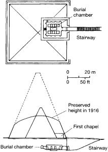
Nuri NAPATAN funerary site located in Upper Nubia, about 25 km southwest of the 4th Nile cataract. Only a few kilometres to the northeast of Napata, the political centre of the kingdom of Kush, it was the burial site of the Kushite royal family from the early 7th to the early 3rd century BC (i.e. later than the tombs at EL-KURRU and earlier than those at southern MEROE). George Reisner identified at least 19 Kushite kings’ burials at Nuri, each
Figure 37 Nuri Plan and cross-section drawing of the tomb of the 25th-dynasty ruler Taharqo, the earliest pyramid at Nuri, Nubia. Source: M. Lehner: The complete pyramids (London, 1997), p. 196.
covered by a small pyramidal sandstone superstructure. Stylistic changes in the architecture of the royal tombs were used by Reisner as the basis for this relative chronology of Kushite kings. More than 50 of the female members of the Napatan royal family were buried in a separate section of the cemetery.
D. Dunham: The royal cemeteries of Kush, II: Nuri (Boston, 1955); W.Y. Adams: Nubia: corridor to Africa, 2nd edn (Princeton, 1984), 278–85.
IS
Nush-i Jan, Tepe |
see MEDES |
Nuzi (Yorgan Tepe) |
Small north Mesopotamian |
settlement located about 13 km from Kirkuk in northern Iraq, where the excavations of Edward Chiera and R.F.S. Starr during the 1920s and 1930s revealed extensive remains of a HURRIAN community dating to the mid-2nd millennium BC. The mound of Yorgan Tepe comprises 12 principal phases of occupation dating from the UBAID period (c.5000–3800 BC) to at least the 14th century BC. The town was initially called Gasur during the Early Dynastic Period (c.2900–2350 BC), but when it was occupied by Hurrians, from the early 2nd millennium BC onwards, it became known as Nuzi and was ruled by a governor subservient to the king of MITANNI. ‘Nuzi ware’, a particular style of painted ceramics found in Mitannian strata at Nuzi, has also been excavated at other Mitannian sites. The site was extensively reoccupied in the PARTHIAN and SASANIAN periods (c.250 BC–AD 651). In 1896 a cache of cuneiform tablets were discovered at Nuzi; combined with later finds, this collection of almost 4000 tablets documents the history of the city during the 2nd and 3rd millennia BC, with a particular concentration of texts in the Mitannian strata (see Contenau 1926; Cassin 1958).
G. Contenau: Les tablettes de Kerkouk et les origines de la civilization assyrienne (Paris, 1926); E. Chiera: Joint expedition with the Iraq Museum at Nuzi, I–V (Paris and Philadelphia, 1927–31); R.F.S. Starr: Nuzi, 2 vols (Cambridge, MA, 1937–9); E. Cassin: ‘Quelques remarques à propos des archives administratives à Nuzi’,
Revue d’Assyriologie et d’Archéologie Orientale 52 (1958), 16–28; M.A. Morrison and D.I. Owen et al., eds.: Studies on the civilization and culture of Nuzi and the Hurrians, 6 vols (Winona Lake, 1981–94).
IS
Nyarunazi Site in Burundi which has one of the fullest sequences of lithic industries in the East
African interlacustrine region, dating from the latter part of the Early Stone Age (Late ACHEULEAN and SANGOAN) to the Middle and Later Stone Age. All the deposits are riverine; the archaeological materials (brought to light during alluvial tin-mining, followed by Nenquin’s excava-
NYARUNAZI 437
tions of 1960) are therefore in secondary situations and do not lend themselves to site-activity analyses as attempted on other East African sites.
J. Nenquin: Contributions to the study of the prehistoric cultures of Rwanda and Burundi (Tervuren, 1967).
JS

O
Oakhurst LSA (Later Stone Age) large rockshelter located 22 miles east of George, Cape Province, South Africa. Excavated in the 1930s, the shelter provided the first direct stratigraphical evidence for the relationship between the entities known then as Smithfield and WILTON, currently seen as ALBANY and Wilton. The site is notable for the 31 burials recorded, often with various grave goods. Basal levels may contain MSA (Middle Stone Age) material.
A.J.H. Goodwin: ‘Archaeology of the Oakhurst Shelter, George’, Transactions of the Royal Society of South Africa, 25/3 (1938), 230–324; J. Deacon: Guide to archaeological sites in the southern Cape. (Stellenbosch, 1979).
RI
Oakhurst Industry see ALBANY INDUSTRY
obelisk (Gk obeliskos) Ancient Egyptian upright vertical shaft, generally of stone or wood, tapering gradually from top to bottom and surmounted by a pyramidion (miniature pyramid). Obelisks were first erected as part of the worship of the sun-god, with the pyramidion representing the sacred benben- stone (perhaps originally a symbol of the primeval mound of creation). In later periods pairs of obelisks were placed in front of the entrances to tombs and temples, as at Karnak and Luxor. An unfinished granite obelisk, probably dating to the 18th dynasty (c.1450 BC), is still in situ at the Aswan quarries.
E. Iversen: Obelisks in exile (Copenhagen, 1972); L. Habachi: The obelisks of Egypt (London, 1978); R. Hayward: Cleopatra’s needles (Buxton, 1978).
IS
oblique photographs see AERIAL
ARCHAEOLOGY
Obobogo Village site near Yaoundé, Cameroon, excavated by Pierre de Maret in 1980–3, where traces of Late Stone Age occupation have been dated to 6020 ± 505 BP. The main ‘Neolithic’ settlement has been dated to between 3625 and
2635 BP, with reliable radiocarbon age determinations for the first occurrence of iron slag at 2310 ± 100 and 2120 ± 70 or 150 BP. A number of pits (also known from about 10 other comparable sites in the area) may have been used for storage, construction or rubbish disposal purposes. Excavated materials include flat-bottomed pottery vessels and polished axes of dolerite, as well as organic remains including nuts of Elaeis guineensis and Canarium schweinfurthii, and charcoal indicative of forest species. De Maret suggests that there is a good parallel between developments at Obobogo and those at sites attributed to the ‘KINTAMPO culture’ in Ghana.
P. de Maret: ‘Le contexte archéologique de l’expansion Bantu en Afrique centrale’, Les peuples Bantu, migrations, expansion et identité culturelle I, ed. Th. Obenga (Libreville and Paris, 1989), 118–44; A. Holl: ‘Néolithique: Cameroun’; ‘L’âge du fer ancien: Cameroun’, Aux origines de l’Afrique Centrale, ed. R. Lanfranchi and B. Clist (Paris, 1991), 148–54, 192–6.
PA-J
obsidian Natural glass formed by the cooling of siliceous magmas from volcanic eruptions and an important resource for stone tool-making. Obsidian was highly valued and widely traded because of its sharp edges, although its brittleness somewhat limits its usefulness in certain activities. Because the chemical composition of obsidian sources varies sensitively, artefacts can be ‘fingerprinted’ by archaeologists and traced to their original source flows, allowing reconstruction of ancient trade networks. Artefacts can also be dated by the OBSIDIAN HYDRATION method (see COPAN), in which age is determined from the degree of alteration of the surface since flaking of the tool, as measured with a special microscope. For Japanese use of obsidian see NOGAWA; for Mesoamerican use see TEOTIHUACÁN and TOLTECS; for North American use see NAMU; for Ancient Near Eastern use see ACERAMIC NEOLITHIC; for East Africa see KARIANDUSI; for Europe see
CYCLADIC CULTURE; and for Oceania see
TALASEA.
A. Lucas: ‘Obsidian’, ASAE 47 (1947) 113–23; R.S.
Santley: ‘Obsidian trade and Teotihuacan influence in Mesoamerica’, Highland-Lowland interaction in Mesoamerica: interdisciplinary approaches, ed. A.G. Miller (Washington, D.C., 1980), 69–124; R.L. Carlson: ‘Trade and exchange in prehistoric British Columbia’, Prehistoric exchange systems in North America II, ed. T.G. Baugh and J.E. Ericson (New York, 1995).
PRI
obsidian hydration dating Scientific dating technique based on the thickness of the hydration layer on a struck surface of obsidian; the layer is the result of the diffusion of water and its thickness depends not only on the time since exposure of the surface, but also on temperature and the type of obsidian (i.e. its source). It does not, however, depend on humidity, as the water uptake is small and there is sufficient in any environment. For a given temperature, the layer thickness increases according to the square root of the age.
Typical layer thicknesses are 1–50 μm (1 μ = 0.001 mm) and can be measured by optical microscopy of a polished section prepared from a V-shaped section at right angles to the surface. The measurement precision is about ±0.1 μm but it may be possible to improve this to ±0.02 by using new techniques. An error of 10% in the thickness measurement produces an error of 20% in the age estimate. The diffusion rate constant for a particular type (source) of obsidian can be determined by measurements at elevated temperature that induce a hydration layer in a short period. Deducing the effective burial temperature is less straightforward, particularly over long periods with significant climatic change (a similar problem is encountered in AMINO ACID DATING). Large systematic errors in age estimate could result, since the rate constant increases exponentially with temperature. The age range depends, at the lower end, on having a layer thickness that is measurable and thus on the rate constant and therefore temperature and, at the upper end, it largely depends on the preservation of the original surface. Published dates range from 200 to 100,000 years.
See also NITROGEN PROFILE DATING and
SODIUM PROFILE DATING.
R.E. Taylor, ed.: Advances in obsidian glass studies – archaeological and geochemical perspectives (New Jersey, 1976).
SB
Oceania Oceania stretches from Papua New Guinea and Australia in the west, to EASTER ISLAND and the Hawaiian Islands in the east. It offers a huge diversity of environment, from the
OCEANIA 439
central Australian deserts to the small atolls of the remote Pacific. The region was settled progressively over a period of at least 60,000 years, with human groups moving into Australia at that date but not reaching New Zealand, the last major landmass on earth to be settled, until around AD 800. As far as we know, even the earliest of these groups were fully modern humans, and Oceania provides a series of case studies in the colonizing abilities of human beings.
Oceania can be divided in a number of ways, depending on the criteria used. Flora and fauna provide a unifying factor: the vast majority of the plants and the animals of the region derived from Gondwanaland, a super-continent comprising South America, southern Africa, India, Antarctica, Sahul (Australia and Papua New Guinea) and New Zealand. The most famous descendants of the Gondwanaland faunas are the marsupials of Sahul and the flightless birds, such as the emu and the extinct MOA. When people first entered the Oceanic region from southeast Asia, they left behind the familiar placental mammals of that region and encountered a whole new range of marsupial species. The only placental mammals found in Oceania today are humans and those species (such as pig, dog and chicken) introduced by humans. Plant species show more continuity than animals, with the rainforests of Papua New Guinea and the western Pacific sharing many plants in common with southeast Asia. However, many of the plants of Papua New Guinea and especially Australia would have been unfamiliar, such as the eucalypts, desert faunas and southern Australian rainforests.
Over the last century it has been established that the main source of species for the island Pacific is Sahul and island southeast Asia rather than the Americas. There is, however, a major biogeographic divide at the eastern end of the Solomon Island chain: east of that point there were no endemic animal species and the structure of plant communities is far simpler (except in New Zealand). The lack of plants and animals may have proved a major barrier to colonizing humans: human groups reached the Solomon chain by almost 30,000 years ago, but do not seem to have moved east of this until around 3500 BP. The Chatham Islands, to the east of New Zealand, were possibly the last part of the Pacific to be settled in prehistoric times – probably by a group known as the Moriori, from the South Island of New Zealand, about 300 years ago.
Sections: 1 Australia and Tasmania; 2 Melanesia, Polynesia and Micronesia
1 Australia and Tasmania. An example of one of the
440 OCEANIA
N
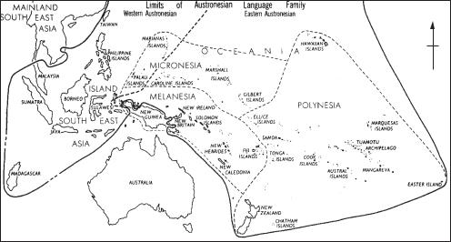
Map 27 Oceania The distribution of Austronesian languages in Oceania.
most ancient Australian sites is Malakunanja, a large rockshelter near the Arnhem Land escarpment in northern Australia. The shelter contained 4 m of deposit, the upper 2.6 m of which yielded stone tools. The lowest artefact-bearing layers have been dated using thermoluminescence to around 50,000 years ago, which would make Malakunanja one of the oldest inhabited sites in Australia – but the dating has aroused controversy. Other early sites include DEVIL’S LAIR, where artefact-bearing layers date from before 33,000 years ago. Sites such as Burrill Lake rock shelter, a large sandstone rock shelter on the south coast of New South Wales, first occupied c.20,000 years ago, preserve HORSE-HOOF CORES and other elements of the early AUSTRALIAN
in the lower layers, while around 5000 BP there was a change to backed blades and tool types of the later
AUSTRALIAN SMALL TOOL TRADITION (Lampert
1971). KENNIFF CAVE helped archaeologists to distinguish these two generic tool traditions, while CLOGG’S CAVE provides another example.
A.R. Radcliffe-Brown, the eminent anthropologist, famously described Australian Aborigines as ‘an unchanging people in an unchanging landscape’. Archaeology has given the lie to this statement across the continent (e.g. the LAKE MUNGO in New South Wales), but perhaps nowhere more so than in Tasmania, where evidence from the Pleistocene has demonstrated the great range of environments to which humans were
obliged to adapt during the last glaciation. Modern humans first entered Tasmania 35,000 years ago, at which time they were the most southerly people on Earth. During the height of the last glaciation, they lived in a sub-antarctic landscape close to upland glaciers. In the southwest of Tasmania, in an area today covered by temperate rainforest, seven limestone caves have been excavated which show that people inhabited this region from 35,000 years ago to the end of the Pleistocene. Glaciers existed at the upper end of mountain valleys in the region, reaching their maximum extent 18,000 years ago. At lower altitudes, grasslands and herbfields attracted wallabies and emus. These species were preyed upon by humans, who left huge amounts of bone in the caves. For instance, in Nunamira cave in the Florentine valley 200,000 pieces of bone were recovered from a cubic metre of soil, and 90% of this bone was from one species: the red-necked wallaby. The presence of emu eggshell shows that these sites were occupied in late winter and early spring, the most difficult period of the year in this subantarctic landscape. It is likely that people were moved through these areas seasonally. Bone points dating back to 26,000 years ago indicate the working of hides and other pliable materials, perhaps to make clothing.
By contrast, at the other end of the Sahulian continent, from about 35,000 years ago, humans occupied the limestone caves of New Ireland, just south of the equator. Here the temperature and
rainfall throughout the last glaciation were little different from today, creating a fully tropical environment. The fact that people adapted to such diverse environments in different parts of the Greater Australian continent soon after the first colonization of that continent testifies to an extraordinary flexibility of response.
2 Melanesia, Polynesia and Micronesia. Outside Australia, the rest of the Pacific is conventionally divided into Melanesia, Ploynesia and Micronesia. Melanesia encompasses the area from Papua New Guinea to Fiji; it thus includes the large islands of the western Pacific and those which were settled first, although, as noted above, Papua New Guinea has a mixed history, having been joined to Australia until 8000 years ago and first settled as early as c.40,000 years ago. Ancient sites in the region include the New Ireland site of MATENKUPKUM. The later site of BALOF CAVE, again on New Ireland, provides evidence for the translocation of animals, while KUK SWAMP, in the Western Highlands of Papua New Guinea, offers some of the earliest evidence for farming in the world, going back to 9000 BP. The evidence from Kuk also illuminates the link between Oceanic economic production and social relations, as does the much later evidence from MOTUPORE. New Britain, the largest island in the western Pacific, is tectonically active, with a ring of volcanoes on the north coast that produced the widely-traded obsidian at TALASEA. New Britain’s prehistory goes back 35,000 years, and open sites such as Yombon have been preserved by volcanic ashes (Pavlides 1993). Extensive excavations in the Arawe Islands on the south coast have revealed many sites with evidence of the LAPITA CULTURAL COMPLEX – a key cultural phenomenon in early Western Pacific prehistory – as well as providing a full picture of the island’s later prehistory (Gosden et al. 1989).
TIKOPIA, a small island (4.6 sq. km) first settled in the Lapita period, lies 200 km north of Vanuatu and 200 km southeast of the Santa Cruz Islands in the Pacific. Recent in-depth studies of the island provide a classic example of the interdependence between landscape, society and subsistence – a recurring theme in Pacific archaeology. Tikopia also exemplifies the way in which the natural flora and fauna of many Pacific islands has been substantially replaced by introduced species – the
notion of ‘TRANSPORTED LANDSCAPES’.
Fiji, on the eastern border of Melanesia, was again settled at the time of the Lapita complex. Fiji’s prehistory is mainly distinguished by changing pottery styles: Lapita styles last until around 2000 BP, when Navatu impressed pottery takes
OCEANIA 441
over, to be superseded by the incised wares of the Vuda (900–400 BP) and Ra (400 BP–present) phases. In the Lapita period, settlement is all coastal; from the Vuda and Ra phases thousands of forts are known, which vary in size and layout from one part of Fiji to another.
Polynesia is often thought of as a triangle, with the Hawaiian group, Easter Island and New Zealand as its three points. In contrast to the diversity of the Melanesian populations, Polynesians all speak closely-related Austronesian languages (see map 27 opposite), and are linked by material culture (e.g. the AHU) and social structure (Kirch 1984). Much of the prehistory of Polynesia has been written in culture-historical terms, with many scholars identifying Polynesian origins in southeast Asia, where the Austronesian languages are thought to have originated. The Polynesian islands range in size from New Zealand (501,776 sq. km) to tiny islands with relatively huge populations, such as Anuta (0.4 sq. km), and are distributed from the equator to sub-antarctic climes. Their cultural history thus provides a good example of how diverse environments can effect change upon one related cultural group; here, the anthropological work of Sahlins (1958) has considerably influenced the practice of archaeology.
Maoris, the indigenous inhabitants of New Zealand (probably east Polynesian in origin), arrived in New Zealand between 800 and 1000 years ago. As recorded in oral histories and the archaeological evidence, there may well have been settlement by more than one group: the north and south islands of New Zealand demonstrate different histories, with agriculture based around sweet potato mainly restricted to the north island, and the fortified PA (earthworks) and the largest MOA hunting sites known from the south island. TONGA represents another Polynesian island with a complex cultural history, while HALAWA VALLEY is an example of a number of alleys in the Hawaiian islands that have now been surveyed archaeologically.
Micronesia, which lies to the east of island southeast Asia and to the north of both Melanesia and western Polynesia, is the area of the Pacific least researched by archaeologists. The earliest dated entry of humans into Micronesia is roughly contemporary with the first moves into Polynesia, at around 3500 BP. The colonists possessed a broadly similar material culture, especially in the form of red-slipped pottery. As in Polynesia, anthropological investigations have heavily influenced archaeology, and one focus of interest has been the growth of stratified societies, such as the Yapese ‘empire’, over the last few hundred years.
442 OCEANIA
Anthropological knowledge about recent social forms has tended to influence archaeologists. Thus Australia is seen as the ‘hunter-gatherer’ continent, settled by egalitarian groups with few of the social divisions found amongst farmers. Melanesia has provided anthropological studies of ‘BIG MAN’ social forms in which personal standing is achieved through manipulating subsistence and trade, rather than through inheritance. (The history of trading systems and their social consequences is central to much of the archaeology undertaken in Papua New Guinea.) In both Micronesia and Polynesia, the growth of chiefdom societies, in places such as Yap, Tonga and Hawaii, has formed the central issue. Much archaeological work in Oceania has been by American scholars, influenced by the EVOLUTIONARY school of anthropologists who worked in the area from the 1950s to the 1970s.
M. Sahlins: Social stratification in Polynesia (Seattle, 1958); R.J. Lampert: Burrill Lake and Currarong
(Canberra, 1971); E.L. Frost: ‘Fiji,’ The prehistory of Polynesia, ed. J. Jennings (Canberra, 1979), 61–81; J. Davidson: The prehistory of New Zealand (Auckland, 1984); P.V. Kirch: The evolution of Polynesian chiefdoms
(Cambridge, 1984); Gosden et al.: ‘The Lapita sites of the Bismarck Archipelago’, Antiquity 63 (1989), 561–86; A. Anderson and M. McGlone: ‘Living on the edge: prehistoric land and people in New Zealand’, The naive lands, ed. J. Dodson (Melbourne, 1992), 199–241; C. Pavlides: ‘Archaeological research at Yombon, West New Britain, Papua New Guinea’, Archaeology in Oceania 28 (1993), 55–9; J. Allen and J.F. O’Connell, eds: Transitions: Pleistocene to Holocene in Australia and Papua New Guinea
[published as special number of the journal Antiquity, 69: (1995) 265].
CG
Oc Eo Rectangular site enclosed by five ramparts and four moats, and covering 450 ha, located in the transbassac region of southern Vietnam. Oc Eo is the key site for appreciating the timing and manner of the entry of Southeast Asia into the great trading network which linked China with India and Rome in the early centuries of the Christian era.
Aerial photographs reveal that Oc Eo was linked by canals to other sites in this flat, low-lying deltaic terrain. Excavations in 1944 by Mallaret uncovered large stone and brick structures in the central area and the remains of industrial activity, such as glass and metal working. A wealth of material items, excavated or purchased from local looters, shows that the site was occupied from the 2nd century AD. Malleret recovered two Roman medallions minted during the reigns of Antoninus Pius (AD 138–161) and Marcus Aurelius (AD 161–180), Iranian coinage, and jewellery engraved in the Brahmi
script of India dated to the late 1st or early 2nd century AD. Further examples of Indian scripts suggest that the site was still occupied three centuries later. A great deal of gold jewellery was found, incorporating a variety of precious and semiprecious stones comprising virtually the entire available range. Pottery was also locally manufactured, and sandstone moulds for casting bronze and tin jewellery were recovered.
The date, monumentality and location of Oc Eo make it highly likely that it was a site of the FUNAN polity, which was described by two chinese emissaries of the Wu emperor, Kang Dai and Zhu Ying, in about AD 250. They reported a country with cities, kings, palaces and a taxation system. There was evidently also contact with India, since the same Chinese emissaries mention that they met a representative of the Murunda king in India.
L. Malleret: L’archéologie du Delta du Mekong (Paris 1959–63).
CH
Ochre Coloured Pottery (OCP) Ceramics associated with the early occupants of the Ganges– Yamuna river basin of northern India c.1800–1400 BC. The OCP ceramics include a wide variety of vessel forms including jars and bowls, pedestalled bowls, and miniature forms (Dikshit 1979: 291), typically wheel-made, poorly fired and coated with a red or orange slip or wash, sometimes with incised or painted decoration.
Remains of the OCP period are known from a number of sites, including Ahichchatra, ATRAN-
JIKHERA and HASTINAPURA. OCP sites have
sometimes been grouped into a single cultural tradition, associated with the similarly defined ‘copper hoard culture’ (see GANGETIC HOARDS), but several specialists have cautioned against this, citing regional variations in vessel forms and surface treatment, and poor chronological and stratigraphic control at many sites. In 1971, the Archaeological Survey of India organized a conference on the OCP in which it was acknowledged that OCP sites should be divided into a western and eastern geographic zone, each with distinctive forms (Gupta 1971–2).
The association of OCP ware with copper hoards is also unclear; both have been found in a number of different contexts, but provenance data is poor and D.P. Agrawal (1982: 208) has suggested that their association is at present only circumstantial, therefore much more research needs to be done to evaluate their relations.
S.P. Gupta, ed.: ‘Proceedings of the seminar on OCP and NBP’, Puratattva 5 (1971–72):1–104; K.N. Dikshit: ‘The Ochre Coloured Ware settlements in Ganga-Yamuna
Doab’, Essays in Indian protohistory, ed. D.P. Agrawal and D.K. Chakrabarti (Delhi, 1979), 285–99; D.P. Agrawal: The archaeology of India (Copenhagen, 1982), 198–210.
CS
Ocmulgee (Macon Plateau) Early MISSISSIPPIAN site in central Georgia (USA) that is thought to intrude into the area from about AD 950–1150, but there is also recent consideration of the role of indigenous cultures in its development. The site contains several large mounds, fortifications, household areas and extensive sets of ridges and furrows for agricultural fields. The most famous structure is a subterranean building 13 m in diameter that has been interpreted as a council chamber. It contains 47 niches (thought to be seats) around the perimeter of the structure, and a raised clay platform ‘throne’ in the shape of a bird with three seats.
C.H. Fairbanks: ‘The Macon earth lodge’, AA 12 (1946), 94–108; D.J. Hally, ed.: Ocmulgee archaeology, 1936–1986
(University of Georgia Press, Athens, 1994).
WB
Ogooué Basin |
see AFRICA 5 |
Ohemir, Tel el- |
see KISH |
Okhotsk Marine-oriented culture found around the coast of the Okhotsk Sea in the islands of Hokkaido, Japan and Sakhalin (Russia), as well as in the southern Kuriles between the 8th and 14th centuries AD. Characterized by large hexagonal houses, elaborate bone working and bear ritualism, it is contemporary with the SATSUMON culture.
C.M. Aikens and D.E. Dumond: ‘Convergence and common heritage: some parallels in the archaeology of Japan and western north America’, Windows on the Japanese past, ed. R. Pearson, K. Hutterer and G.L. Barnes (Ann Arbor, 1986), 163–78.
SK
Okvik culture see OLD BERING SEA CULTURE
Olbia Important Greek (Ionian) colony, later a city-state, situated on the Bug-Dniestr Liman (estuary), near the town of Ochakov in the Ukraine. The site has been excavated by Russian and Ukrainian archaeologists since the 1850s. The earliest Greek settlement emerged on the island of Berezan in the Bug-Dniestr estuary in the late 7th century BC. The Olbia township appeared in
OLD COPPER 443
the mid-6th century and flourished especially in the 5th–4th centuries BC, when a network of agricultural settlements appeared in the hinterland. The density of Greek settlement declined in the late 3rd century BC. The city further declined in the 2nd–1st centuries BC, when it was controlled by the SCYTHIAN kings. There was a substantial development in the 1st–3rd centuries AD, and in the middle of the 2nd century AD, a Roman garrison was stationed in Olbia. The city ceased to exist in the 4th century AD.
E.I Levi, ed.: Olvia: temenos i hora (Leningrad, 1964); S.D. Kryzhytsky: Olvia (Kiev, 1985).
PD
Old Bering Sea culture This, and the closely related Okvik culture, represent the earliest phase of the THULE TRADITION (1st–6th century AD). Sites are found primarily on islands in the Bering Strait, but are also known on the adjacent Siberian shores. The economy is based primarily on the exploitation of sea mammals. The complex and intricate carving styles found on most implements
– not seen on similar items from later in the Thule tradition – have been interpreted as having magical significance, and may indicate close cultural ties with societies in east Asia.
O.W. Geist and F.G. Rainey: ‘Archaeological excavations at Kukulik, St Lawrence Island, Alaska’, Miscellaneous Publications of the University of Alaska 2 (1936); H.B. Collins: ‘Archaeology of St Lawrence Island, Alaska’,
Smithsonian Miscellaneous Collections 96 (1937).
RP
Old Copper Term used in North American archaeology to refer to the copper artefacts of the Late Archaic period (c.3000–1000 BC) found throughout the Lake Superior Basin, particularly in eastern Wisconsin. Once thought to represent the remains of a specific culture (Old Copper Culture),
Figure 38 Old Bering Sea culture Intricately carved harpoon head, Old Bering Sea culture, Alaska. Source: O.W. Geist and F.G. Rainey: Archaeological excavations at Kukulik, St Lawrence Island, Alaska (Washington D.C.: University of Alaska Publications, 1936), fig. 41.
444 OLD COPPER
these artefacts are now recognized as having been manufactured by a variety of Late Archaic groups that lived throughout the Great Lakes region. Much that is known about Old Copper derives from vandalized cemeteries such as the Oconto, Osceola and Reigh sites in Wisconsin, providing a rather biased view of the cultures that produced these artefacts. The native copper used to manufacture the artefacts came from sources in Wisconsin and Michigan, of which Isle Royale (Michigan) is the best known. The most common Old Copper artefacts are awls, tanged knives, projectile points, semi-lunar objects or crescents, gouges and axes.
T. Ritzenthaler, ed.: ‘The Old Copper culture of Wisconsin’, The Wisconsin Archaeologist 38 (1957), 185–329; R. Mason: Great Lakes archaeology (New York, 1981), 181–99; J. Stoltman: ‘The Archaic tradition’,
Wisconsin archaeology: background for cultural resource planning, ed. W. Green, J. Stoltman and A. Kehoe (Madison, 1986), 207–38.
RJE
Old Crow Flats Locality in Yukon, Canada, that has provided controversially early radiocarbon dates for the arrival of humans in the Americas. The redeposited river deposits produced quantities of modified bone from extinct animals, and a small number of undoubted artefacts. A cariboutibia fleshing tool produced the early date of c.27,000 ± 3000 BP; however, a recent AMS date on the flesher produced an age of only 1350 ± 150 BP. In fact, all the undisputed artefacts have been shown to be less than 3000 years old. While, many of the modified bones do appear to be Pleistocene in age, their status as artefacts remains in doubt.
R. Morlan et al.: ‘Accelerator Mass Spectrometry dates on bones from Old Crow Basin, Northern Yukon Territory’,
Canadian Journal of Archaeology, 14 (1990), 75–92.
RP
Old Minster (Winchester) West Saxon Cathedral, which was excavated in 1962–9 by Martin Biddle and Birthe Kjølbye-Biddle, where
they developed OPEN-AREA EXCAVATION tech-
niques that have been subsequently adopted throughout western Europe. The Biddles unravelled the complex of robber trenches left after the building was demolished in AD 1093–4, to illustrate how the cathedral evolved. The Old Minster was founded in AD 648 by King Cenwalh, then enlarged in the 9th and 10th centuries. The painstaking excavations showed that the architectural development of a great basilica could be documented archaeologically if excavated following
scientific principles. The Biddles subsequently employed the same methods at two other medieval sites in England: Repton minster church and St Albans cathedral.
M. Biddle: ‘Archaeology, architecture, and the cult of saints in Anglo-Saxon England’, The Anglo-Saxon church, ed. L. Butler and R. Morris (London, 1986), 1–31; B. Kjølbye-Biddle: ‘The seventh-century minster at Winchester interpreted’, The Anglo-Saxon Church, ed. L. Butler and R. Morris (London, 1986), 196–209.
RH
Olduvai, Oldowan Gorge in Tanzania which has become almost synonymous with the quest for human origins, following the discoveries of the remains of early humans and near-humans made by Mary and Louis Leakey from 1959 onwards. The massive erosion gully – about 100 m deep – cuts through the southern edge of Serengeti plain, facing Ngorongoro and the Crater Highlands. It reveals a succession of Pleistocene lake-beds, the lowest nearly two million years old. The obvious geochronological and palaeo-environmental importance of this unparalleled sequence of exposed deposits is enhanced by their containing fossilized bones of numerous animals (in most cases extinct species of modern African genera). Equally important is the stratified succession of Early Stone Age tools and flakes, mostly of the ACHEULEAN (handaxe) tradition, but in the lower beds, dating before 1.5 million years, belonging to the Oldowan (sometimes called ‘pebble-tool’) tradition.
The geological and palaeontological importance of Olduvai was recognised by Hans Reck, who worked there in 1913, but unfortunately his materials were lost during the First World War. In 1931 he returned to Olduvai with Louis Leakey, who quickly appreciated the site’s archaeological potential, although it was not until 1959, after several subsequent expeditions, that significant fossils of early man and near-man were discovered at the site. That year the find of the Zinjanthropus skull (nicknamed ‘Nutcracker Man’ because of its massive jaw and teeth) set the scene for much more intense research effort and international funding. At the time it was believed that the low bed containing Zinjanthropus was only 0.5 million years old, and that this specimen might represent the makers of the associated tools. Both views were rapidly overturned in a flurry of scientific activity and debate. It was established by POTASSIUM-ARGON tests that this bed with the skull and tools was about 1.75 million years old: this more than tripled the chronology of the whole Olduvai sequence, and by extension the Pleistocene worldwide – let alone