

A Dictionary of Archaeology
.pdfand there are indications of specific commercial connections between them in the 14th century, although culturally and architecturally the two sites seem unrelated.
The site of Kilwa, situated on an island in a sunken estuary of the southern Tanzanian coast, was excavated in the 1960s by Neville Chittick (1974). With its lowest levels dating to the early 9th century AD – as at SHANGA and Manda in the north, Mkumbu on Pemba and Unguja Ukuu on Zanzibar
– it rose to prominence in the 11th century when a sultanate was established, copper coinage minted and the first stone mosque built. The domed, arched and barrel-vaulted extension to Kilwa’s Great Mosque, as well as the magnificent palace and trade emporium called Husuni Kubwa, date to that period. There followed a severe slump during which Husuni Kubwa was abandoned and much of the Great Mosque collapsed. Early in the 15th century the trade of gold and other items revived, and Kilwa with it; it is to this period that most of the stone domestic architecture of Kilwa town (and the adjacent island of Songo Mnara) belongs.
Mombasa overtook Kilwa in the 15th century to become the biggest such settlement on the East African coast. Together with its fine harbour, in the creek between Mombasa island and the mainland, Mombasa’s central position on the coast gave it an advantage, especially for the bulk commerce with India. Because of the continued occupation and growth of the town till the present, nothing is visible of the pre-1500 period and little systematic archaeological investigation has been attempted. The most impressive monument at Mombasa is Fort Jesus, which was built in the 1590s by the Portuguese (employing an Italian military architect) to command the harbour approach and to serve as their headquarters on the Swahili coast.
Following Vasco da Gama’s voyage of 1498–9 and the Portuguese invasion of the Indian Ocean from the south, the commerce and wealth of the Swahili coast declined sharply (see PORTUGUESE TRADING FEIRAS). After the ending of Portuguese control there was a revival in the late 18th century, fuelled by renewed international demands, for ivory and slaves especially. This is illustrated at several sites by renewed stone buildings, which included forts.
J.S. Kirkman: Men and monuments on the East African coast
(London, 1964); P.S. Garlake: The early Islamic architecture of the East African coast (Nairobi and London, 1966); H.N. Chittick: ‘An archaeological reconnaissance of the southern Somali coast’, Azania 4 (1969), 125–30; ––––:
Kilwa: an Islamic trading city on the East African coast
(Nairobi, 1974); J.S. Kirkman: Fort Jesus, BIEA 4
SWIDDEN AGRICULTURE 555
(Oxford, 1974); H.N. Chittick: Manda: excavations at an island port on the Kenya coast (Nairobi, 1984); M.C. Horton, H. Brown and W.A. Oddy: ‘The Mtambwe hoard’, Azania 21 (1986), 115–23; M.C. Horton: ‘Early Muslim trading settlements on the East African coast: new evidence from Shanga’, AJ 67 (1987), 290–323; J.E.G. Sutton: A thousand years of East Africa (Nairobi, 1990), 57–88.
JS
Swartkrans Ancient fissure with breccias of various ages, close to Krugersdorp, Transvaal, South Africa. Four stratigraphic Members are identified and dated on the basis of contained fossils. Member 1, rich in Australopithecus robustus specimens, is around 1.6–1.8 million years old and contains bone ‘digging-tools’ in the upper part (see AUSTRALOPITHECUS). Member 2 (>1.0 my, <1.6 my) contains A. robustus and Homo (sp.indet.), a few stone artefacts of ACHEULEAN aspect, bone tools, and abundant mammal bones, many with cutmarks and some showing signs of burning.
C.K. Brain: The hunters or the hunted?: an introduction to African cave taphonomy (Chicago, 1981); ––––: ‘New information from the Swartkrans cave of relevance to “Robust” australopithecines’, Evolutionary history of the “robust” australopithecines, ed. F.E. Grine (New York, 1988), 311–16.
RI
Swasey-phase pottery see CUELLO
swidden agriculture Method of farming in which a swidden (strip of agricultural land) is obtained by cutting down, drying and burning the existing natural vegetation, thus clearing the area for cultivation. The system therefore includes the use of the ‘slash-and-burn’ technique (or Brandwirtschaft), whereby the ash from the wild vegetation can be employed as a fertilizer in the soil. The swidden land, however, can be cultivated successfully for only a few years, therefore farmers using this method are obliged to move on periodically to exploit new areas of land. The swidden system was used by many prehistoric groups, such as the people of Preclassic Mesoamerica (see LOWLAND MAYA) and some of the Neolithic inhabitants of central and northern Europe (although see LINEARBANDKERAMIK for a discussion of the possible limitations on the use of swidden agriculture in prehistoric Europe).
P. Bogucki: Forest farmers and stockherders (Cambridge, 1988).
IS
556 SYMBOL
symbol see SIGN
symbolic archaeology Study of the use and importance of symbolism in material culture, and how this can be recognized and recovered from the archaeological record. Symbolic archaeology forms one of the most fruitful parts of a general movement in archaeology towards an ‘archaeology of the mind’ – and towards a more sophisticated understanding of how material culture was perceived and manipulated in ancient societies. In part a reaction against the more materialist and func-
tionalist aspects of PROCESSUAL ARCHAEOLOGY,
this general movement encompasses the work of Ian
Hodder’s CONTEXTUAL ARCHAEOLOGY, Colin Renfrew’s COGNITIVE ARCHAEOLOGY (which he
describes as developing out of processual archaeology, rather than contradicting it), and STRUCTURALISM, as well as an increasing volume of diverse individual studies.
In this still-developing field, four key areas of interest can be defined. Firstly, how do we define the terms sign and symbol and relate them to their social context? Ian Hodder (1987: 11–12) defines the symbol as ‘an object or situation in which a direct, primary or literal meaning also designates another indirect, secondary and figurative meaning’ and argues that ‘symbols do not “reflect” but . . .
play an active part in forming and giving meaning to social behaviour’. Most archaeologists in this area have turned to the key works in social anthropology, which in turn inherited many key concepts (see SIGN AND SYMBOL) from linguistic analysis. However, a key confusion in social anthropology over the question of whether the signified and signifier of a symbol are truly arbitrary seemed likely to pose a particular problem when interpreting material culture. The more arbitrary the link, the more difficult the task of interpreting symbols in the archaeological record. Hodder (1992: 207) suggests that they are indeed arbitrary, but with an important qualification: ‘Blood, for example, has qualities which constrain its symbolic meaning but a range of specific meanings (from danger and death to the source of life) can be given . . . The ideological implications of this duality are that the meanings of objects, while imposed by convention, appear based on necessity’. In other words, the particular meaning of symbols arises out of social convention (i.e. is arbitrary in the sense that the signified is not linked to the signifier by any existential or representational link), but symbols often gain power and a sense of inevitability from innate references to the wider world.
Secondly, and given this, how can archaeologists define and recognise the conventional meaning of individual symbols in material culture, without the help of the written records or living witnesses available to ethnographers and historians? A central problem here is the verification of any interpretation of a symbolic meaning. Simply testing our interpretation of symbols by seeking out further instances in the material culture record inevitably leads to charges of circularity and subjectivity.
Thirdly, and moving on from the problem of interpreting individual symbols, archaeologists have tried to understand the relationship between different signs and symbols, to identify underlying rules that govern the generation of symbolic and decorative patterning. This line of enquiry can be divided up into FORMAL ANALYSIS, where the meaning (content) of signs and symbols tends to take second place to their patterning, and structuralist analysis (see STRUCTURALISM), where in many analyses the meaning of symbols is both important and directly related to their structuration (e.g. Leroi-Gourhan’s structuralist analysis of the symbolic meaning of CAVE ART).
Lastly, and perhaps most interestingly, there has been an increasing understanding of the ways in which symbols are actively manipulated by social players. Here, Marxist archaeologists have investigated how individuals use symbols as tools within a wider cultural ideology or world view – the ‘social production of reality’. Aside from Marxist analyses, there has also been a strong tendency to stress the active role of the individual and of subordinate groups within society in manipulating and using symbols to promote their social ambitions. In part, these analyses (e.g. Hodder 1982a) have been used to warn against simplistic functionalist or materialist interpretations of material culture in the archaeological record. Symbols have come to be seen as powerful ‘tools’ for individual and group strategies as much as expressions of the NORMATIVE beliefs (shared world-views) of whole societies. While significantly complicating interpretation, such studies also hint at the potential richness of material culture studies in revealing the true complexity of social groups and their symbolic interactions.
M. Douglas: Purity and danger (London, 1966); V. Turner: The forest of symbols (London, 1967); ––––: The ritual process (London, 1969); M. Douglas: Natural symbols (London, 1970); D. Sperber: Rethinking symbolism (Cambridge, 1974); I. Hodder: Symbols in action: ethnoarchaeological studies of material culture (Cambridge, 1982a); ––––, ed.: Symbolic and structural archaeology
(Cambridge, 1982b); ––––: The present past (London,

1982c); A.C. Renfrew: Towards an archaeology of mind
(Cambridge, 1982); I. Hodder: ‘The contextual analysis of symbolic meanings’, The archaeology of contextual meanings, ed. I. Hodder (Cambridge, 1987), 1–10; C. Tilley, ed.: Reading material culture (Oxford, 1990); I. Hodder: Material practice, symbolism and ideology, in Theory and practice in archaeology (London, 1992), 201–12; K.A. Hays: ‘When is a symbol archaeologically meaningful? Meaning, function and prehistoric visual arts’,
Archaeological theory: who sets the agenda?, ed. N. Yoffee and A. Sherratt (Cambridge, 1993), 81–92.
RJA
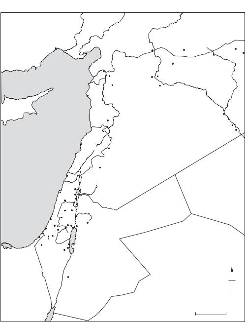
Syria-Palestine Part of Western Asia bordering the Mediterranean, situated between Anatolia in the north, and the Arabian desert and Mesopotamia to the south and east. It comprises two basic topographical zones: a long coastal strip to the west, and an area of uplands to the east, the latter broken by a north–south geological fault incorporating the Sea of Galilee, the Dead Sea and the Wadi Arabah. For discussion of some of the ancient cultures and
peoples, see AMORITES, ARAMAEANS, CANAAN-
Kebaran period |
18,000 – 11,000 BC |
||
Natufian period |
11,000 |
– 9300 BC |
|
Pre-pottery Neolithic period A |
9300 |
– 7000 BC |
|
Pre-pottery Neolithic period B |
7000 |
– 5500 BC |
|
Pottery Neolithic A |
5500 |
– 4500 BC |
|
Pottery Neolithic B |
4500 |
– 3500 BC |
|
Ghassul-Beersheba culture |
4200 |
– 3500 BC |
|
Proto-urban period |
3500 |
– 3100 BC |
|
Early Bronze Age I |
3100 |
– 2800 BC |
|
Early Bronze Age II |
2800 |
– 2600 BC |
|
Early Bronze Age III & IV |
2600 |
– 2180 BC |
|
Middle Bronze Age I & II |
2180 |
– 1550 BC |
|
Late Bronze Age I |
1550 |
– 1400 BC |
|
Late Bronze Age II |
1400 |
– 1200 |
BC |
Late Bronze Age III |
1200 – 1150 |
BC |
|
Iron Age I |
1150 |
– 1000 |
BC |
Saul |
1030 |
– 1000 |
BC |
David |
1000 |
– 960 BC |
|
Solomon |
960 |
– 931 BC |
|
Rehoboam (King of Judah) |
931 |
– 913 BC |
|
Jeroboam I (King of Israel) |
931 |
– 910 BC |
|
Iron Age II |
1000 |
– 587 BC |
|
Neo-Babylonian Empire |
587 |
– 538 BC |
|
Achaemenid Empire |
538 |
– 331 BC |
|
Alexander the Great |
332 |
– 323 BC |
|
Ptolemaic Empire |
323 |
– 198 BC |
|
Seleucid Empire |
198 |
– 142 BC |
|
Hasmonean Dynasty |
142 |
– 63 BC |
|
Roman Empire |
63 BC – AD 395 |
||
Herod the Great |
|
40 – 4 BC |
|
Pontius Pilate |
AD 27 – |
30 |
|
Herod Agrippa I |
AD 40 – |
44 |
|
Table 18 Syria-Palestine Chronology of
Syria–Palestine.
SYSTEMS THEORY 557
ITES, ISRAEL, KEBARAN, NATUFIAN, PHILISTINES
and PHOENICIANS. (See map 30.)
Y. Aharoni: The land of the Bible: a historical geography, 2nd edn (Philadelphia, 1979); K.M. Kenyon: Archaeology in the Holy Land, 4th edn (London, 1979); M. Roaf:
Cultural atlas of Mesopotamia and the Ancient Near East
(New York and Oxford, 1990).
systems theory Approach to understanding complex phenomena by characterizing them as bounded ‘systems’ within which distinguishable interdependent elements (subsystems) or units interact to form the whole. In archaeological analysis, subsystems often include ‘economy’, ‘politics’, ‘kinship’ etc. The interactions are often characterized as information flows, set in motion by flows from the outside environment. In essence, systems theory attempts to facilitate the identification of systems, subsystems and system elements, as well as the nature and level of their information flows. It has been self-consciously used in archaeological explanation since the mid-1960s and the advent of
PROCESSUAL ARCHAEOLOGY, notably in the
writings of David Clarke (1968) and Kent Flannery (1968).
While systems theory, in its widest sense, developed in the natural sciences and especially in biology, the concepts and terms used to describe the nature of natural systems were adopted by the social sciences from an early date. The founder of modern sociology, Emile Durkheim, used the analogy of the bodily system to explain his essentially FUNCTIONALIST views of how society was organized and remained in equilibrium. (Poets and philosophers had employed the analogy in a less systematic manner since the dawn of history.) In later sociological writings, Herbert Spencer (1820–1903), who believed that society must learn to consciously control key social mechanisms, and Vilfredo Pareto (1848–1923), an Italian mathematical economist who helped to develop equilibrium theory (see below), developed and formalized the concept of a social ‘system’. In the work of Talcott Parsons (1902–79), sociological systems theory was used to hugely elaborate a functionalist view of social institutions. Parsons’ ‘structuralfunctionalism’ was based on the premise that systems functioned in various ways to achieve four things: adaptation to the physical environment; goal attainment; integration (i.e. social cohesion and orderliness); and latency (i.e. system stability). Parsons believed that four subsystems could be identified in society that accorded with these aims: the economic system, political system, community
558 SYSTEMS THEORY
Mersin
Tell Atchana
Amuq
Ebla
Ras Shamra (Ugarit)
T U R K E Y
Carchemish |
|
Harran |
|
|
Chagar Bazar |
||
|
|
|
|
|
|
||
|
|
|
|
|
Tell Brak |
||
|
|
|
Tell Halaf |
|
|
||
|
|
Tell Aswad |
|
|
|
|
|
Habubaabuba |
Mureybet |
|
|
|
|
|
|
KebiraKer |
|
|
|
|
|
||
Tell Abu Hureyra |
E |
|
|
|
|
|
|
|
|
u |
|
|
|
|
|
|
|
|
p |
|
|
|
|
|
|
|
h |
|
|
|
h |
|
|
|
r |
|
|
|
|
|
|
|
a |
|
|
k |
|
|
|
|
|
t |
|
|
|
|
|
|
|
e |
|
|
i |
|
|
|
|
s |
B |
e |
l |
|
|
|
|
|
|
|
|
C Y P R U S
Bouqras
Qatna
Qadesh
Dura-Europus
Mari
MEDITERRANEAN |
|
L E B A N O N |
|
|
Byblos |
S Y R I A |
|
|
|
||
SEA |
|
|
Jabrud |
|
|
i |
|
|
|
an |
|
|
it |
|
|
|
L |
|
|
|
|
|
|
Damascus |
|
|
|
Tyre |
|
|
|
|
|
Wadi Amud |
|
||
Mount Carmel Caves |
|
Sea of Galilee |
|||
|
Khirbet Kerak |
Munhata |
|||
|
Megiddo |
|
|||
|
Beth Shan |
||||
|
|
|
|||
Tell el-Far’ah (N) n |
|
||||
|
Samaria |
a |
|
||
|
|
|
d |
|
|
Wadi el-Natuf |
r |
|
|||
o |
|
||||
Jaffa |
|
J |
Amman |
||
|
Gezer |
|
|||
Ashdod |
Jericho |
||||
Beth |
Ai |
|
Teleilat Ghassul |
||
Ashkelon |
|
Qumran |
|||
Shemesh |
|||||
Jerusalem |
|||||
Gaza |
|||||
Lachish |
|
||||
|
|
||||
Tell el-Hesy
Tell el-Far’ah (S) |
Masada |
Ain Gedi |
|
Dead Sea |
|||
|
|||
|
Tell Arad |
||
|
|
||
I S R A E L |
|
||
|
|
J O R D A N |
|
|
|
Beidha |
|
I R A Q
S A U D I
A R A B I A
N
0 |
100 km |
Map 30 Syria–Palestine Major sites in ancient Syria–Palestine.
system, and the system of socialization (i.e. social education in its widest sense). Information flowed to and from the subsystems in the form of money, power, influence etc.
The details and over-elaborate nature of Parsons’ scheme, hugely influential in the 1960s, are now
largely set aside in anthropology and have only tentatively been applied in archaeology. However, there have been numerous attempts by archaeologists to use the basic concepts and language of systems theory to describe how they believe prehistoric societies may have been structured.
Key concepts in systems theory. The core concepts are information media and information flow: boundary maintenance; feedback; and equilibrium. Information media describe the form in which information flows through a system (e.g. money might be regarded as information within an economic system). Information flow describes the mechanisms of information storage, control and output. Boundary maintenance describes the mechanisms within systems that define the elements that comprise the system itself, and separate it off from other systems and its wider environment. Within social systems, for example, it is often claimed that system boundary concern is manifested in concentrated symbolic and ritual activity.
Feedback, a concept borrowed from the physical sciences, describes how the output of a system or subsystem continually feeds back into the system to control the level or character of subsequent output. Positive feedback leads to a continual increase in output, and thus to instability or change. For example, in an agricultural system in which the harvester gathers the most productive stands of cereal to preserve for next year’s planting, each crop will contain successively more wheat with that beneficial characteristic – and this may happen quite quickly because of the nature of the system (i.e. grain is selected for planting). Colin Renfrew used a form of positive feedback which he called the ‘multiplier effect’ to explain the emergence of Aegean civilization: ‘changes or innovations occurring in one field of human activity (in one subsystem of a culture) sometimes act so as to favour changes in other fields (in other subsystems). The multiplier effect is said to operate when these induced changes in one or more subsystems themselves act so as to enhance the original changes in the first subsystem’ (Renfrew 1972; 37).
Negative feedback describes a subsystem relationship which tends to dampen down the effects of any change in system output and thus promote system stability. In the agricultural system described above, if harvesters had the habit of consuming the most productive stands of cereal then this might slow down the evolution of productive agricultural systems – and associated changes in other subsystems. Note that the harvesting actions in this example are essentially the same – it is the effect on the next cycle of the subsystem that determines whether the feedback is positive or negative, relatively strong or relatively weak.
In common speech, equilibrium is a term used to describe a state of balance. One of the more questionable (and tautological) assumptions of the elaborated form of systems theory in sociology was
SZELETIAN 559
that all systems tended toward either a ‘steady state’ of equilibrium with regard to the environment in which they existed, or changed only according to an ‘orderly process’. This assumption, implicit or explicit, is one of the principal weaknesses of the approach. It underlines the ahistorical character of many interpretations of social systems relying on systems theory. However, it is only really through the notion of equilibrium that systems theory appears to have explanatory and predictive power when applied to real-world situations. Without it, systems theory becomes (and is now often recognized as) a simplifying descriptive framework (see Shanks and Tilley 1987: 31–6, 138–43).
In more developed discussions of systems qualities, notions such as ‘hypercoherence’ can help us to understand complex system behaviour that would otherwise be difficult to grasp. Hypercoherence is simply the label given to a system that is both closely integrated and very delicately balanced: a crisis in one subsystem quickly leads to massive change or disruption in the other subsystems and the system as a whole. However, like other concepts in systems theory, it is largely helpful as a means of conceptualizing and making more plausible a sequence of interactions between social entities. Because interactions between social subsystems are not, and never will be, quantifiable, systems theory cannot itself offer proof of any argument in the social sciences. See also WORLD
SYSTEMS THEORY.
D.L. Clarke: Analytical archaeology (London, 1968); K. Flannery: ‘Archaeological systems theory and early Mesoamerica’, Anthropology and archaeology in the Americas, ed. B. Meggers (Washington, D.C., 1968); J.E. Doran: ‘Systems theory, computer simulations and archaeology’, WA 1 (1970), 289–98; C. Renfrew: The emergence of civilization: the Cyclades and the Aegean in the third millennium BC (London, 1972); F. Plog: ‘Systems theory in archaeological research’, ARA 4 (1975), 207–24; C. Renfrew: Approaches to social archaeology (Edinburgh, 1984); B.G. Trigger: A history of archaeological thought
(Cambridge, 1989), 303–12; M. Shanks and C. Tilley:
Social theory and archaeology (Cambridge, 1987).
RJA
Szeletian Intermediate Middle to Upper Palaeolithic industry of Moravia and western Slovakia and northeast Hungary, named after the Szeleta Cave in the Bükk Mountains of Hungary. The Szeletian may have developed out of the Middle Palaeolithic Central European Micoquian, but it presents blades and core-preparation techniques of a distinctly Upper Palaeolithic type. As well as ‘Middle Palaeolithic’ side scrapers, the tools
560 SZELETIAN
produced include end-scrapers and burins. The most striking artefacts are the finely made bifacial leaf-shaped points, which grew larger and more elongated as the Szeletian progressed. In the past these leaf points have led archaeologists to construe some link with the much later SOLUTREAN industries, although this is now usually discounted. Split-based bone points have also been found at Szeleta Cave. At Szeleta Cave the ‘Early’ Szeletian is dated to c.41,000 uncal BP and the ‘Developed’ to c.32,000 uncal BP. These dates suggest that even the ‘Early’ Szeletian may be contemporaneous with the early Aurignacian, a variant of which is dated to 39,700 ± 900 uncal BP at the other Hungarian site of Istállóskö. This contemporaneity has led Philip Allsworth-Jones and others to suggest that
the Szeletian is an acculturated version of the
AURIGNACIAN produced by NEANDERTHALS. The
Szeletian in Central Europe would therefore occupy the same position as the CHÂTELPERRONIAN or Lower PERIGORDIAN in Western Europe. This theory assumes that the Neanderthals were replaced
by ANATOMICALLY MODERN HUMANS, a premise
not universally accepted.
P. Allsworth-Jones: The Szeletian and the transition from Middle to Upper Palaeolithic in Central Europe (Oxford, 1986); J.K. Kozłowski: ‘The transition from the Middle to the early Upper Palaeolithic in Central Europe and the Balkans’, The early Upper Palaeolithic, eds. J.F. Hoffecker and C.A. Wolf, BAR IS 437 (Oxford, 1988), 193–237; M. Oliva: ‘The Szeletian in Czechoslovakia’, Antiquity 65 (1991), 318–25.
RJA

T
Tabun see MOUNT CARMEL
Tadrart Acacus see AFRICA 1
Taforalt see AFRICA 1
Tagajo Garrison of the 8th and 9th centuries AD in Miyagi prefecture, northern Japan, which was one of several centres for frontier administration mentioned in historical records in connection with attempts by the central state to subdue groups such as the Emishi. Excavations since 1961 have revealed extensive earthworks and wooden slips bearing ink inscriptions.
Tohoku Historical Museum and the Miyagi Prefectural Tagajo Research Institute: Tagajo to kodai Tohoku [Tagajo and ancient Tohoku] (Sendai, 1985).
SK
T’ai-hsi-ts’un (Taixicun) Site of the SHANG period (2000–1122 BC), near the village of T’ai-hsi- ts’un, in the central Ho-pei province of China. It is one of three large earth mounds in the area, which was excavated in 1973–6; bringing to light the remains of 14 houses, two wells, over 100 burials and many pits. Building remnants include some parts of the roofs which indicate the method of gabling employed; the overall structures comprise wooden posts and beams with wall fillings of rammed earth, or sun-dried brick. Wooden frames supported the well bottom, and, significantly, they were found to have been laid out in the shape of the character ching (‘well’).
Over two thousand artefacts were recovered, including pottery, stone and bone implements, ORACLE BONES (uninscribed), turtle shells, LACQUER remnants, hemp fabric, gold foil, bronze vessels, bronze knives and weapons. A bronze yüeh- axe with an iron blade has become the basis of controversy as to the antiquity of iron manufacture in China. The iron in this axe, and two others like it, is apparently of meteoritic origin; as it would necessarily require smithing in its manufacture,
such a worked material would be more likely to have been a cultural intrusion.
Anon.: Kao-ch’eng T’ai-hsi Shang-tai yi-chih [The Shang period remains at Kao-ch’eng, T’ai-hsi] (Peking, 1985).
NB
Taixicun see T’AI-HSI-TS’UN
Takamatsuzuka Late Kofun-period (AD 300–710) mounded tomb in Nara prefecture, Japan, famous for its painted murals depicting the Chinese directional symbols on the plastered walls of the tomb. The stone chamber is in a small round mound. Recent opinions suggest artistic influence from the Chinese Tang dynasty (AD 618-907) on this tomb of an aristocrat from the YAMATO state.
C.M. Aikens and T. Higuchi: The prehistory of Japan (London, 1982), 284–5.
SK
Takht-i Sulaiman see PARTHIANS; SASANIANS
Talasea Series of obsidian sources deriving from volcanoes on the north coast of West New Britain, Papua New Guinea. Obsidian from Talasea has been used continuously from 20,000 years ago, the earliest examples deriving from New Ireland cave sites such as BALOF CAVE. During the time of the
LAPITA CULTURAL COMPLEX, Talasea obsidian
was distributed widely, ending up in Sabah, Malaysia to the west and Fiji to the east. See also
OCEANIA 2.
R. Torrence ‘What is Lapita about obsidian? A view from the Talasea sources’, Poterie, Lapita et peuplement, ed. J.C. Galipaud (Nouméa, 1992), 111–26; C. Gosden et al.: ‘The Lapita sites of the Bismarck Archipelago’, Antiquity 63 (1989), 561–86.
CG
talayots (talaiots; ‘watchtowers’) Monumental round or rectangular drystone tower-like structures characteristic of the full Bronze Age – or Talayotic Period – in the Mediterranean Balearic
562 TALAYOTS (TALAIOTS; ‘WATCHTOWERS’)
islands (Majorca and Minorca). The absolute dates of the talayot phenomenon are unclear, but may run from c.1500 BC to c.800 BC or later. Talayots, which occur singly and in groups, are often compared to the NURAGHI of Sardinia, although they are smaller and simpler in form and lack a sophisticated corbelling technique. They may have acted as places of refuge or as central strongpoints for local powers.
G. Rossello-Bordoy: La cultura talayotica en Mallorca
(Palma, 1979); R. Chapman and A. Grant: ‘The Talayotic monuments of Mallorca, formation processes and - function’, Oxford Journal of Archaeology 8 (1989), 55–72.
RJA
talud-tablero Mesoamerican style of templepyramid construction associated with the site of TEOTIHUACAN, in which each tier or terrace of the substructure was composed of two parts: a sloping apron (talud) topped by a flat, rectangular panel (tablero).
G. Kubler: ‘Iconographic aspects of architectural profiles at Teotihuacán and in Mesoamerica’, The iconography of Middle American sculpture (New York, 1973), 24–39.
PRI
Tamaya Mellet see AFRICA 1.1
tambo Groups of storehouses and shelters located at intervals along roads by the INCA.
Tam My see SA HUYNH
founded by Psusennes I (c.1020 BC). In 1939–40 he discovered the relatively undisturbed tombs of some of the rulers of the 3rd Intermediate Period, complete with much of the original funerary equipment, a discovery which would perhaps have brought Montet the same fame as Howard Carter had it not coincided with the outbreak of the Second World War.
W.M.F. Petrie: Tanis, 2 vols (London, 1885–8); P. Montet: La nécropole royale de Tanis, 2 vols (Paris, 1947–60); H. Stierlin and C. Ziegler: Tanis: trésors des pharaons (Paris, 1987); J. Yoyotte et al.: Gold of the pharaohs (Edinburgh, 1988); P. Brissaud: ‘Tanis: the golden cemetery’, Royal cities of the biblical world, ed. J. Goodnick Westenholz (Jerusalem, 1996), 113–70.
IS
T’ao-ssu (Taosi) Extensive site of the Neolithic LUNG-SHAN culture (c.4000–2000 BC), near the village of T’ao-ssu-ts’un, Hsiang-fen-hsien, Shanhsi, China. Still only partly excavated, it primarily consists of a cemetery area that is estimated to cover an area of 30,000 sq.m, containing several thousand burials, about a thousand of which have been excavated. Calibrated radiocarbon dates range from c.2875 to 1905 BC.
Chang Kwang-chih: The archaeology of ancient China, 4th edn (New Haven, 1986), 275–9; N. Barnard: ‘Thoughts on the emergence of metallurgy in pre-Shang and Early Shang China and a technical appraisal of relevant bronze artifacts of the time’, BMM, Sendai, 19 (1993), 3–48.
NB
Tanis (anc. Djaðnet; San el-Hagar) Egyptian town, temple and royal cemetery located in the Nile delta about 130 km northeast of Cairo. It was capital of Egypt for much of the 3rd Intermediate Period (c.1070–712) and continued to flourish until the early Roman period (c.30 BC). The preservation of Tanis, a typical tell-site covering some 180 ha, has been greatly assisted by its location in one of Egypt’s poorest areas of agricultural land, which has tended to protect it from the depredations of farmers digging for fertilizer (the so-called sabakhin), unlike other post-New Kingdom sites such as SAIS and MENDES. Because of the large number of Ramessid monuments at Tanis, both Auguste Mariette and Flinders Petrie mistakenly identified the site with Piramesse, the city said to have been founded by Ramesses II in the Delta (which is now known to have been located at QANTIR and TELL EL-DABðA). From 1929 to 1952 Pierre Montet excavated the site, concentrating on the precincts of the temple of Amun, which was
Taoudenni Basin The southeastern part of the Taoudenni basin, within the Republic of Mali, has been investigated by N. Petit-Maire and her colleagues since 1980. This area, lying between 17° and 24° N, presently forms part of the Sahara and has an annual precipitation of 50–55 mm, but the investigation has demonstrated that during the early Holocene rainfall is likely to have reached 400–250 mm, and there were several freshwater lakes, as well as an extensive Neolithic occupation of this region. Dates obtained on molluscs suggest that there were two main humid phases, a major one from 9500 to 6000 BP and a minor one from 5000 to 4000 BP. After 3000 BP the region was deserted. The early phase of occupation is dated to 6970 ± 130 BP at Hassi el-Abiod and 6340 ± 130 BP at Erg Ine Sakane. At both localities, large middens contained an abundant fauna, with fish, crocodiles, turtles, snakes, bovids, hippos and antelopes, as well as artefacts and human burials. The tools, apart from geometric microliths, also include polished stone axes, fish hooks and grinding equipment, taken to
indicate the exploitation of wild grasses. There are numerous bone harpoons (>100 at one site) similar to those found at ADRAR BOUS and Shaheinab (KHARTOUM NEOLITHIC), and pottery which at Erg Ine Sakane includes wavy-line and dotted wavy-line motifs. At Hassi el-Abiod 89 skeletons were recovered from 16 sites. These according to O. Dutour form a homogeneous ‘Cromagnoid’ population, which in terms of metrical characteristics is very close to the ‘Mechtoids’ from the North African IBEROMAURUSIAN sites of Afalou and Taforalt. As Petit-Maire says, this similarity ‘may be a result of early Holocene trans-Saharan migrations or a common Aterian ancestry’. ATERIAN stone tools were found in situ beneath thick deposits of sand and silt at Sbeita northwest of Taoudenni, and stratigraphically they may correspond to palaeolake deposits 130 km away dated to 21,000 ± 300 BP.
N. Petit-Maire et al.: ‘The Sahara in northern Mali: man and his environment between 10,000 and 3500 years BP (Preliminary results)’, AAR 1 (1983), 105–25; N. PetitMaire: ‘Palaeoclimates in the Sahara of Mali: a multidisciplinary study’, Episodes 9/1 (1986), 7–16; ––––
and O. Dutour: ‘Holocene populations of the Western and Southern Sahara: Mechtoids and paleoclimates’,
Prehistory of arid North Africa, ed. A.E. Close (Dallas, 1987), 259–85.
PA-J
Ta-p’en-k’eng (Dapenkeng) Neolithic site near Taipei, which is one of the best-studied prehistoric sites on the island of Taiwan (see Chang et al. 1969) and is also the type-site for the Ta-p’en-k’eng culture. This culture is characterized by cordmarked pottery (the cord-marks demonstrating the existence of highly sophisticated cordage techniques), stone net-sinkers, shell-mounds, woodworking implements such as stone adzes and chisels (illustrating the possibility of boat building), and bark-beaters (for the production of fibres for rope-making). Some form of agriculture may have been practised but the obvious means of subsistence was hunting, fishing and collecting. The culture, along with others related to it, is represented in sites on the Chinese mainland, a few of which are located directly opposite, in Fu-chien, but many have been recognized in Kuang-tung and coastal Kuang-hsi. Calibrated radiocarbon datings indicate a span of 5000–3000 BC, thus making it contemporary with such cultures as Ma-chia-pang and HO-MU-TU to the north, in Chiang-su and Che-chiang, TA-WEN- K’OU in Shan-tung, and YANG-SHAO in the Huang-ho River Basin.
Chang Kwang-chih et al.: Fengpitou, Tapenkeng, and the Prehistory of Taiwan (New Haven, 1969); Chang Kwang-
TARDENOISIAN 563
chih: The archaeology of ancient China, 4th edn (New Haven, 1986), 228–33.
NB
taphonomy Palaeontological term coined by I.A. Efremov in 1940 to describe the study of the transformation of organic remains into fossil deposits as a result of spatial, temporal and biological factors. The term has been used by archaeologists since at least the early 1980s to describe the transformation of bone (and sometimes other material) in the archaeological record, i.e. the
organic aspects of SITE FORMATION PROCESSES.
The most useful applications of taphonomy include the work of C.K. Brain (1981), studying faunal remains associated with australopithecine hominids at the South African site of SWARTKRANS, and the ethnoarchaeological researches of Lewis Binford (1981), distinguishing between patterns of faunal remains created by dogs, wolves and humans at various sites in North America.
I.A. Efremov: ‘Taphonomy: a new branch of paleontology’, Pan-American Geologist 74 (1940), 81–93; A.K. Behrensmeyer and A.P. Hill: Fossils in the making: vertebrate taphonomy and paleoecology (Chicago, 1980); L.R. Binford: Bones: ancient men and modern myths (New York, 1981); C.K. Brain: The hunters or the hunted? An introduction to African cave taphonomy (Chicago, 1981); D.P. Gifford: ‘Taphonomy and paleoecology: a critical review of archaeology’s sister disciplines’, Advances in archaeological method and theory 4, ed. M.B. Schiffer (New York, 1981), 365–438.
IS
Tarascans Late Postclassic state in the state of Michoacán in western Mexico, with its capital at Tzintzuntzan, on the shores of Lake Pátzcuaro. Claiming CHICHIMEC ancestry, the Tarascans maintained an uneasy frontier with the AZTECS to the south and were known for their fine metalworking, especially in copper.
D.D. Brand: ‘An historical sketch of geography and anthropology in the Tarascan region, Part 1’, New Mexico Anthropologist 6 (1943) 37–108.
PRI
Tardenoisian Term applied to an ill-defined group of Mesolithic assemblages, characterized principally by the presence of asymmetrical trapezes (pointe tardenoisienne) and long blades. First identified at Fère-en-Tardois in southwest France, the assemblages date from about 6000 BC into the 5th millennium. Assemblages with Tardenoisian characteristics can be identified across

564 TARDENOISIAN
Europe from Iberia to Sweden (excluding Britain, presumably because eustatic changes had recently created the English Channel), centring on northern France. Tardenoisian assemblages are generally thought to post-date assemblages defined as
MAGLEMOSIAN and those defined as SAUVE-
TERRIAN; however, the relationship with the Sauveterrian has been the subject of much debate since the 1950s, as summarized by Peter RowleyConwy (1986). There is some limited evidence that hunters and gatherers using lithic industries of Tardenoisian character existed at the same time as early farming groups in northern France, that the two economies occupied different landscape zones, and that there was a (limited, except perhaps in Brittany) degree of contact and cultural interchange.
C. Barrière: Les civilizations Tardenoisiennes en Europe Occidentale (Paris, 1956); R. Parent: ‘Le peuplement préhistorique entre le Marne et l’Aisne’, Travaux de l’institut d’art préhistorique de l’Université de Toulouse 13 (1971); S.K. Kozłowski, ed.: The Mesolithic in Europe (1973); P. Rowley-Conwy: ‘Between cavepainters and crop planters: aspects of the temperate European Mesolithic’, Hunters in transition, ed. M. Zvelebil (Cambridge, 1986), 17–29.
RJA
el-Tarif see SAFF-TOMB
Tarkhan Religious and funerary site in the Nile valley, about 60 km south of Cairo, excavated by Flinders Petrie in 1912–13. The main components of the site comprise a temple dating to the 9th–7th centuries BC and a number of cemeteries ranging in date from the late predynastic to the Roman period (c.3200 BC–AD 395).
W.M.F. Petrie et al.: Tarkhan and Memphis V (London, 1913); W.M.F. Petrie: Tarkhan II (London, 1914);
IS
Taˇ rtaˇ ria Romanian Neolithic site of the VincˇaTordos culture, famous for the discovery in a pit of three clay tablets bearing signs that were once claimed to be related to the pictographs used in the JEMDET NASR period in Mesopotamia – an inter-
pretation that clashes with the accepted ˇ
VINCA
chronology and is now discounted. The signs may represent some simple form of notation, or religious symbolism, but researchers no longer regard them as ‘proto-writing’.
RJA
0 |
3 cm |
Figure 53 Taˇrtaˇria Inscribed clay tablets from Tartaria,ˇ ˇ Transylvania, Romania. Source: A. Whittle: Neolithic Europe: a survey (Cambridge, 1985), fig. 3.15.
Tasmania see OCEANIA 1
Tassili-n-Ajjer see AFRICA 1
Tatetsuki Very large Late Yayoi (AD 100–300) burial mound in Okayama prefecture, Japan which has provided good evidence for the burial customs of regional chiefs and insight into the extent of indigenous Japanese origins of the keyhole-shaped mounded tombs of the succeeding Kofun period
(see JAPAN 3–4).
Y. Kondo, ed.: Tatetsuki mound of the Yayoi period
(Okayama, 1992) [in Japanese with English summary].
Tasian see BADARIAN |
SK |