

I N T R O D U C T I O N
CLIMATE AND VEGETATION
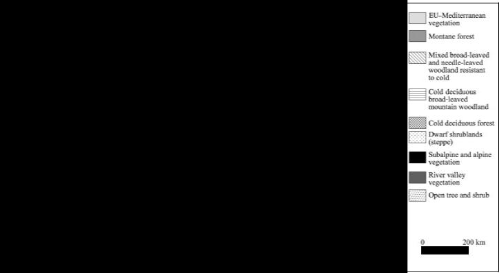
Putting aside the vagaries of contemporary global warming, the climate of Turkey is one of extremes. Coastal Turkey is mostly humid, with parts of the western shores never experiencing frost, yet the eastern highlands can be covered with snow for several months of the year. Shielded from rain-bearing winds by mountains, the central plateau of the interior is semiarid, yet the Black Sea coast has an abundance of precipitation, with annual rainfall reaching about 2500 mm. In outlining the modern vegetational zones of Turkey, or indeed of the Near East, it is the potential natural plant cover that is reconstructed by palynologists and ecologists rather than the actual present day cover. This should be evident by looking across Turkey’s landscape today. Deforested for the most part, it is a stark testimony of millennia of human interference on a grand scale. Ecologists have calculated that about 70% of Turkey has the potential to maintain a forest cover, and yet today only 14% can be considered arboreal vegetation of which more than half is coppiced woodland.5 Over 30 years ago, Zohary sketched the modern vegetation of the Near East,6 and since his monumental work others have refined the vegetation patterns. Here we follow the reconstruction proposed by van Zeist and Bottema, who identify nine broad vegetational zones (Figure 1.4).7
From these broad potential vegetation patterns, we need to move back in time and observe the history of climate change and plant cover. Given that plants in the eastern Mediterranean area are closely tied to a cycle of winter rain and summer drought, the patterns of ancient vegetation can be reconstructed from palynological evidence, which is sometimes integrated with lake-level readings for more accurate determinations. In interpreting the pollen diagrams, we should bear in mind the differences in rainfall needs, with trees requiring more rainfall than shrubs and herbs.
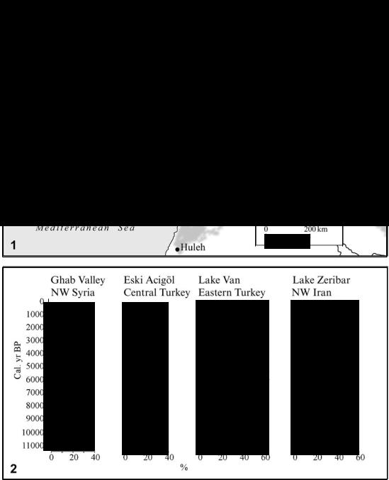
Turkey has 10 pollen diagrams that are relevant to Late Quaternary and Holocene vegetation history, with most cores taken in regions west of the Euphrates (Figure 1.5: 1). This constitutes the largest body of data from western Asia, but should nonetheless be studied against the information from neighboring regions, including Iran (the fundamental core from Lake Zeribar), Syria, and the Caucasus, which has many pollen diagrams, the most recent from southern Georgia.8
The pollen diagram from Lake Van (Figure 1.6: 1) broadly matches that from Lake Zeribar in general character, namely a treeless steppe vegetation gradually giving way to oak woodland. But unlike the radiocarbon-dated Zeribar core, the chronology of the Van diagram has been problematic, owing to the use of varve counting.9 Even so, it remains a key source on ancient highland vegetation, and its dating has been rectified somewhat through new data from a nearby peat bog. The pollen curves we now have from Van and Zeribar both show the gradual replacement of herbs such as Artemisia and chenopods, typical of cold steppe landscapes, by an oak and pistachio woodland around 10,500 years ago that reaches its full extent some 4000 years later.
This transition from steppe to woodland is also apparent in the pollen diagrams from west Anatolian sites, with the spread of trees occurring between 11,000 and 9000 years ago.10 While
5
Black Sea
Mediterranean Sea
N |
|
D EO-Mediterranean |
|
||
|
vegetatiOn |
|
A |
|
|
|
D Montane forest |
|
|
|
|
|
|
~Mixed broad-leaved |
|
|
~and needle-leaved |
|
|
woodland resistant |
|
|
to cold |
|
|
~Cold deciduous |
|
|
~broad-leaved |
|
|
mountain woodland |
|
|
ml Cold deciduous forest |
|
|
~Dwarf shrublands |
|
|
L::..J (steppe) |
|
• |
Subalpine and alpine |
:i]lll~ |
|
vegetatwn |
• |
River valley |
|
|
vegetatwn |
|
: |
p_{:;:j Open tree and shrub |
|
0 200km
Figure 1.4 Map showing the natural vegetation zones of Turkey (adapted from Van Zeist and Bottema 1991: fig. 4)
I N T R O D U C T I O N
N 0 o |
---N _lf:~:=~::;'" |
|
Herb and grass pollen IIIIII;'II Ephedra (joint pine) |
Betula (birch) Pistacia (pistachio) |
Quercus (oak) |
|
Pinus (pine) Juniperus'; (juniper) |
Chenopodiaceae (saltbush) |
Artemisia(wonnwood) |
Poaceae (grass) |
Cerea/ia type (cereal) |
Pollen zones |
||||||
Depth(em)o |
|
|
|
|
|
|
|
|
|
|
|
|
|
|
|
|
|
|
|
|
|
|
|
|
|
|
|
|
|
|
|
|
|
|
|
|
|
- 0 o |
|
rlm(lulti:I~ |
|
co 0 t2:'l::t~~~.II I I I; I I I I I '; I I I I I |
|
|
|
|
I o ' :w |
|
|
|
|
|
||||
00 0 o |
.........~ |
0, 0 |
|
|
|
|
|
|
|
|
|
|||||||
|
.... l - ' |
|
|
|
|
|
|
|
|
|
|
|
|
|
|
|
|
|
o 0 W |
|
|
|
|
|
|
|
|
|
|
|
|
|
|
|
|
|
|
o 0 ~ |
J::::.. |
|
|
|
|
|
|
|
|
|
|
|
|
|
|
|
|
|
|
- |
|
|
|
|
|
|
|
|
|
|
|
|
|
|
|
|
|
~ 0 |
.10\U. |
|
|
|
|
|
|
|
|
|
|
|
|
|
|
|
|
|
o |
|
|
|
|
|
|
|
|
|
|
|
|
|
|
|
|
|
|
|
- |
|
|
|
|
|
|
|
|
|
|
|
|
|
|
|
|
|
0 |
ooo... |
|
|
|
|
|
|
|
|
|
|
|
|
|
|
|
|
|
~ o |
|
|
|
|
|
|
|
|
|
|
|
|
|
|
|
|
|
|
|
-· |
|
|
|
|
|
|
|
|
|
|
|
|
|
|
|
|
|
~ 0 o |
|
|
|
|
|
|
|
|
|
|
|
|
|
|
|
|
|
|
....lo. |
|
|
|
|
|
|
|
|
|
|
|
|
|
|
|
|
|
|
|
|
|
|
|
|
|
|
|
|
|
|
|
|
|
|
|
||
|
|
|
|
|
|
|
|
|
|
|
|
|
|
|
|
|
||
|
|
|
|
|
|
|
|
|
|
|
|
|
|
|
|
|
||
Depth (em) |
Radiocarbon ages C'C yr BP) |
Tree and shrub pollen |
|
Herb and grass pollen |
Cedrus (cedar) |
|
|
Ahies (fir) |
Pinus (pine) |
|
|
Fraxinus ornus (manna ash) |
Quercus (oak) |
Juniperus (juniper) Chenopodiaceae (saltbush) Artemisia (wonnwood) |
Cerealia type (cereal) |
Poaceae (grass) Pollen zones |
||
° |
|
|
|
|
11 |
|
|
|
|
|
|
|
|
|
|
|
|
|
g g g 8 8 |
|
|
~1111. |
I I I I I I 1.1 I I I I I I I I 1. I I .rPCI |
|
|
|
|
|
|
|
|
|
|
|
|
||
|
|
§Ill I !:] I I I |
>? |
|
|
|
|
|
|
|
|
|
|
|
||||
|
|
|
|
|
|
|
|
|
|
|
|
|
|
|||||
1\) |
|
|
|
|
|
|
|
|
|
|
|
|
|
|
|
|
|
|
Figure 1.6 1 Pollen diagram from Lake Van, eastern Turkey (adapted from Van Zeist and Woldring 1978; Wick et al. 2003). 2 Pollen diagram from Beys¸ehir Gölü, southwestern Turkey, showing the dramatic change in the curve as a result of forest clearance (adapted from Roberts 1990, 2000)
8
I N T R O D U C T I O N
oak dominated the eastern highlands in the early Holocene, here in the western Taurus, it shared the forest cover with pine, cedar and juniper, with pine eventually becoming the most common tree (Figure 1.5: 2). A similar trend is reflected in the pollen count taken from the northwestern cores.11 This decline in oak is of particular interest because it coincides with a rise in plants such as olives, walnuts, vines, and hemp between 3500 and 2000 years ago, which corresponds roughly to the Late Bronze through Iron Age in the archaeological record. Climate and volcanic activity are unlikely causes for this shift. Rather, this interlude in the pollen records from western
Anatolia, the so-called Beysehir Occupation Phase (Figure 1.6: 2), is a stark testimony to
12 ˙
human agency. It reflects the influence that farmers, who cleared the forests to make way for crops and their herds had on the landscape. The most likely forest clearance procedure was slash and burn (or swidden) cultivation—burning down woodland and cultivating with hoes in the ash-enriched soil. Plough agriculture, suited to the grass cover of the plains, would not have been used among the charred stumps and tangled roots. This deforestation was largely responsible for the disappearance of oak woodlands in southern and western Anatolia, which enabled the hardier pine to take hold wherever it could in an already eroded terrain. At the moment, however, Neolithic landuse is not detectable in the pollen records of Anatolia, a situation that will no doubt change with an increase in the precision and number of pollen diagrams.13
NOTES
1See Georgacas 1969 for a detailed discussion of the etymology of the name Asia.
2Greaves 2007.
3The most detailed account of tectonics is found in Dixon and Robertson 1984; see also Fisher 1978.
4A general introductory geography is Dewdney 1971. Accounts of Turkey in relation to the Middle East can be found in Held 1995 and Anderson 2000.
5Van Zeist and Bottema 1991: 23.
6Zohary 1973.
7Van Zeist and Bottema 1991.
8Connor 2006 thoroughly reviews these pollen data as a background to his own palynological field work in Georgia, southern Caucasus.
9Van Zeist and Bottema 1977 (Zeribar); van Zeist and Woldring 1978 (Van); for more recent palynological studies around Lake Van, see Bottema 1995; Wick, Lemke, and Sturm 2003.
10Bottema and Woldring 1984; Bottema and Woldring 1990; Vermoere et al. 2002.
11Beug 1967; Bottema and Woldring 1990.
12Roberts et al. 1997; Roberts 2002.
13For an interpretation of the Zeribar diagram involving anthropogenic factors, see Pullar 1977.
9
2
EARLIEST ARRIVALS
The Palaeolithic and Epipalaeolithic
(1,000,000–9600 BC)
In Europe, the Palaeolithic, covering the period from the first appearance of tool-using humans in Africa to the retreat of the Ice Age at ca. 11,000 BC, has attracted attention for well over a century.1 The study of this vast stretch of prehistory in Anatolia, by comparison, is a fledgling field, which is represented by only a handful of systematically excavated sites and a comparatively small number of dedicated researchers (Figure 2.1).2 One reason for this situation is the difficulty of finding early Palaeolithic sites, which are often covered by later sediments and represented by ephemeral traces of human activity. Even so, the Türkiye Arkeolojik Yerles¸meleri (TAY—Turkish Archaeological Settlements) project has listed over 200 localities bearing Palaeolithic artefacts.3 The other, more pertinent, reason for this sparsity of knowledge is neglect. Until very recently the Palaeolithic has simply been overshadowed by the intensity of research devoted to the later historic cultures. Yet it offers enormous potential to world prehistory, especially given the penchant for travel of Homo erectus and his relatives. As the most likely path anatomically modern humans took as they migrated from Africa through the Near East to Europe and central Asia, Anatolia no doubt played a crucial role in the peopling of the Old World. It is most likely, for instance, that Dmanisi, in southern Georgia, currently the earliest known hominid site outside Africa, where rich hominid (Homo ergaster) and artefactual finds have confirmed settlement between 1.7 and 1.8 million years ago, was reached by crossing Anatolia.4
During this time, which defines the boundary of the Plio-Pleistocene, the Anatolian peninsula was generally quite warm and humid.5 With the onset of the glacial ages, climates changed significantly to colder and drier conditions.6 Glaciers covered the highest peaks in the Taurus and Pontic mountains where they extended to as low as 1700 m. Elsewhere peri-glacial conditions (thawing during the day, freezing at night) were widespread, creating colluvial soils. Among the most conspicuous footprints of the Quaternary (Pleistocene) era are the numerous lakes that were formed, some as early as the Pliocene, through progressive uplifts and
10

PA L A E O L I T H I C A N D E P I PA L A E O L I T H I C
Figure 2.1 Map of Turkey showing the Palaeolithic and Epipalaeolithic sites. Only a handful has been excavated
downdrops. The most notable are Tuz Gölü (Salt Lake) in the heart of Turkey, Lake Burdur and a handful of others in the southwest, and Lake Van in the east.7 In addition to these, a series of shallow lakes once dotted the central Anatolia plateau around Konya. Together, these bodies of water created a unique climatological background, which must be appreciated when studying cultural developments in Anatolia. Multiple shore terraces indicate that the size of these lakes changed, expanding or contracting with respect to rainy conditions (pluvials) or arid periods.8 At times, the lakes contained fresh, or mildly brackish, water, enough to support populations of the clam Dreissencia. Even though these bodies of water would have attracted the early
11