

brechignac_f_desmet_g_eds_equidosimetry_ecological_standardi
.pdfECOSYSTEMS OF 30-KM ZONES OF KHMELNYTSKY AND RIVNE NPP: ESTIMATION OF MIGRATION CONDITIONS OF THE RADIONUCLIDES AND OTHER TECHNICAL POLLUTANTS
L. MALYSHEVA
Center of Ecological Monitoring of Ukraine, Glushkov Prospekt 2, korp.5 Kiev, 02127, UKRAINE
L. SOROKINA
Institute of Geography, NASU, Volodymirska str., 44, Kiev, 01034, UKRAINE
A. GALAGAN, S. GAYDAY, A. GRACHEV, O. GODYNA,
S. DEMYANENKO, S. KARBOVSKAYA, R. MALENKOV, A. NOSON
Center of Ecological Monitoring of Ukraine Glushkov Prospekt 2, korp.5 Kiev, 02127, UKRAINE
1. Introduction
Khmelnytsky and Rivne NPP are two Ukrainian nuclear power stations, where new blocks are built. Their working has to compensate the closing of Chornobyl NPP. Increase of stations capacity by means of the new blocks exploitation requires more detailed estimation of their influence upon the environment. The 30-km zones of radiological control around Khmelnytsky and Rivne NPP were explored. The aim of our investigation was to estimate landscape premises of back reactions of nature upon the NPP’s probable negative pressure.
|
The main research tasks are the following: |
ξ |
to describe the 30-km zones soil cover; |
ξ |
to analyse the landuse structure; |
ξ |
to carry on an investigation of landscape and landscape-geochemical structure; |
ξ |
to estimate landscape and landscape-geochemical conditions of 137Cs and 90Sr |
|
migration. |
The methodological base of the investigation is the use of a landscape approach. It enables to analyse the ecosystems as a genetically unit formation. Investigation of landscape-geochemical structure is also necessary to estimate Khmelnitsky and Rivne NPP influence on environment.
A territorially indivisible image of the transfer of the pollutants is possible by means of using the knowledge about landscape and landscape-geochemical conditions of the migration process coming about in the ecosystems.
The main investigation methods are: expedition to landscape and landscapegeochemical exploring; using data of the geochemical analysis; landscape mapping; using GIS-technologies to treat pervious data base, making special thematic and complex maps.
369
F. Brechignac and G. Desmet (eds.), Equidosimetry, 369–376.
© 2005 Springer. Printed in the Netherlands.
370 |
|
|
The base information to decide the main tasks is the following: |
ξ |
The results of the expedition of landscape and landscape-geochemical exploring |
|
(above 500 complex observation points for the 30-km zone of each NPP) |
ξ |
Geochemical analyses data (by the results of the exploring expedition) |
ξ |
Analysis data of the physico-chemical and water-physical soil properties which |
|
were made in the years 1980-1990 (the results of State soils exploring of Ukraine) |
ξ |
Publications and materials about the geological and geomorphology structure, soil |
|
and vegetation cover of the explored territory; topographic maps (scales 1:25 000; |
|
1:100 000). |
2. Landscape structure of the exploring polygons
The significant nature diversity of the Khmelnitsky NPP 30-km zone territory reflects upon its landscape and landscape-geochemical structure, upon the diversity of the water-physical soil properties.
The NPP (its 30-km zone) is situated in the West-Ukrainian province of the Lesostepp zone; it includes the parts of the Volynska and Pivnichnopodilska high plains, Mizochsky chain of hills, Maloye Polissya (forested lowland). The first, second and third of them are the Lesostepp regions of the loess denudated-accumulated and denudated-structured high plains and more low-loess accumulated plains. The top levels of Lesostepp regions is from 220-320 m. The main soil types there are grey forest soils, chornozem podzolic and typical chornozem, and the main soilforming rock – loess loam.
Maloye Polissya is the area with outwash-alluvial and terrace landscapes of the Mixed forest zone. Soddy-podzolic sandy soils are representative to the Maloye Polissya. This is the lowest part of the explored territory (average high level – about 200 m).
The Rivne NPP 30-km zone has a less contrasted landscape structure. This is a part of Volynske Polissya (forested lowland). Chalk-rock plays an essential role in the geological structure of the territory. It is mainly covered with antropogenic sediments. The landscapes of mixed forest zone, namely morainic ridges, moraine-outwash plains, terraces and alluvial plains are typical for the explored part of the Volynske Polissya.
The central part of the Rivne NPP 30-km zone is the highest relief level of the territory (average spot heights 170 – 200 m). There is Volynska morainic ridge from West to East of the 30-km zone. Soddy-podzolic sandy soils and oak-pine forests are representing the landscapes of morainic ridges. The ecosystems of the North part of the Rivne NPP 30-km zone are low sandy terraces and alluvial plains (150 – 165 m) densely with a swamp forests and meadows. The South part of the 30-km zone is the area where ecosystems of the outwash accumulative and terrace plains (average spot heights 165 – 175 m) are predominating. Soddy-podzolic, sod and sod carbonate dustysandy and loamy-sandy soils are representing the territory. The good fertility of the soils allows to productively making use of the territory for agriculture.
371
3. Landscape-geochemical conditions of the territory: investigation methods; characteristic of the polygons explored
The aim of the landscape-geochemical mapping is to study the geochemical background of the chemical elements (natural substances and pollutants) migration. Maps of such kind are used to analyse and estimate the territory ecological condition, the factors of the pervious and secondary pollutants distribution, the space particularity
of geochemical influence on the biota and the health of people [2, 3]. The series of factor maps and complex maps shows landscape-geochemical migration conditions of
the explored territory.
Landscape information is the base for these maps. Thematic classifiers are worked out and MAPINFO-operations (Thematic Mapping, SQL Query) are used for the mapping.
Chemical elements, which have concentration Clarks more than a one were determined. Clark is an average content (in %) of an element in Earth’s crust. Concentration Clarks is a correlation between Clark of the element in soil at present place and the average Clark of the element in Earth’s crust. Isolines maps of these elements distribution were made. Chemical elements, which have content (in %) in soil at present place more than its average content in Earth’s crust were determined. Isolines maps of these elements distribution were made.
Landscape-geochemical map contains information about classes, types, families and species of Landscape-Geochemical Systems (LGS). Type of the LGS determines “stable” geochemical background. Class of the LGS determines the “mobile” geochemical background; subclass, family and specie are showing physicochemical properties of LGS. These properties have a principal role for the formation of the chemical elements migration and accumulation conditions [4].
The particularity of geochemical and biogeochemical processes reflectsthe complicated landscape structure of the Khmelnytsky NPP 30-km zone territory According to our investigation the ecosystems of the Khmelnitsky NPP 30-km zone are composed of 14 geochemical classes by typeforming elements (table 1).
Forest-steppe landscapes on the calcareous loess rocks abound at the Khmelnitsky NPP 30-km zone territory. This is why calcium is one of the most important typeforming elements here. Ecosystems of the calcium class (Ca2+) compose 12% of the territory; more then 1/3 of the territory being composed by ecosystems of the transitional acid calcium class (H+-Ca2+). Such geochemical classes are characteristic for ecosystems, which have weak acid soil reaction and not a deep occurrence of carbonate in soil horizons. There are ecosystems of the acid calcium| acid, acid-gleyic class (H+-Ca2+| H+, H+-Fe2+) representing about 13% of the territory. The formation of these landscape-geochemical conditions is connected to the high level of
the ground water in depressive landforms.
LGS of the acid (H+), acid, acid gleyic (H+, H+-Fe2+) and acid gleyic (H+-Fe2+) classes are abounding mainly in the central part of the Khmelnytsky NPP 30-km zone, in the Male Polissya. It is a typical landscape-geochemical feature of the outwashalluvial plains.
Landscapegeochemical diversity of the Rivne NPP 30-km zone territory is less than the territory around Khmelnitsky NPP. The ecosystems of the Rivne NPP 30km zone compose only 6 geochemical classes by typeforming elements.
Typical for forested lowland’s ecosystems classes of migration is the abundance here of acidity: acid class (H+) – 23%, acid, acid gleyic class (H+, H+-

372
Fe2+) – 22% and acid gleyic class (H+-Fe2+) – 50% of the territory. This geochemical situation is developing in the territory were poor sandy soils and bog soils are predominant. Cretaceous sediments do not significantly influence on the geochemical background. Hardly any part of the territory contains Ca among the LGS typeforming chemical elements. This landscape-geochemical specifity can be explained by a lot of parameters Quaternary has deposited over the Cretaceous rocks here.
Table 1. Geochemical classes of the ecosystems (by typeforming elements) of the Khmelnytsky and Rivne NPP 30-km zones territories
|
Geochemical classes |
Chemical indexes |
% of the territory |
|
|
|
|
Khmelnytsky |
Rivne |
|
|
|
NPP |
NPP |
1 |
Acid |
H+ |
5,6 |
23,6 |
2 |
Acid, acid gleyic |
H+, H+-Fe2+ |
3,5 |
23,0 |
3 |
Acid gleyic |
H+-Fe2+ |
12,2 |
50,0 |
4 |
Acid calcium |
H+- Ca2+ |
35,2 |
0,5 |
5 |
Acid calcium | acid, acid |
H+-Ca2+|H+, H+-Fe2+ |
13,2 |
- |
|
gleyic |
|
|
|
6 |
Acid calcium | acid gleyic |
H+- Ca2+|H+-Fe2+ |
3,6 |
- |
7 |
Calcium |
Ca2+ |
12,0 |
- |
8 |
Calcium | acid, acid gleyic |
Ca2+|H+, H+-Fe2+ |
1,2 |
0,4 |
9 |
Calcium | acid gleyic, |
Ca2+|H+-Fe2+ |
5,0 |
2,5 |
10 |
Calcium carbonate |
Ca2+-CO32- |
3,7 |
- |
11 |
Calcium-carbonate | acid, |
Ca2+-CO32-|H+, H+-Fe2+ |
0,5 |
- |
|
acid gleyic |
|
|
|
12 |
Calcium carbonate | acid |
Ca2+-CO32-|H+-Fe2+ |
4,0 |
- |
|
gleyic |
|
|
|
13 |
Salt |
Ca2+-SO42- |
0,1 |
- |
14 |
Salt | acid gleyic |
Ca2+-SO42- |H+-Fe2+ |
0,2 |
- |
4. Landscape-geochemical barriers of the exploring polygons
The places of the mostly probable accumulation of the natural and technological elements are shown on the Landscape-Geochemical Barriers (LGB) maps. Contrasting landscape-geochemical migration conditions is the main cause of the different kinds and types of the landscape-geochemical barriers. The ecosystem characteristics, which are causing a severe change of the migration conditions of the chemical elements, and their space situation, were defined.
Landscape-geochemical map and analysing of LGB-forming factors is the base for landscape-geochemical barriers mapping. LGB of the exploring territories were classified according theirs forms (linear and sheet barriers), transfer mechanism (diffusing and infiltrating barriers), genesis (natural and technological).
373
Dependence on the formation mechanism and main kind of migration of each LGB type is to divided in classes: mechanical, physico-chemical, biogeochemical.
Landscape and landscape-geochemical particularities of the territories around Khmelnytsky and Rivne NPP show that conditions of chemical elements transfer and conditions of the ecosystem’s secondary pollution are different here.
5. Estimation of migration conditions of the radionuclides and other pollutants
One of the principal tasks of the investigation is the complex estimation of the ecosystems as a scene of radionuclides transfer by water and biogenic migration.
Research experience [1] shows the advantages of using a landscape approach to decide on the problems devoted to forecasting of the radionuclides behaviour in the environment. Pollutants join in natural processes of the cycle of matter. Therefore geochemical conditions and migration processes intensity depend on the structure and dynamics of the contaminated territory landscapes. Landscape approach allows to making a complete picture of the potential capacity of ecosystems to carrying out, to transporting and to accumulating the different pollutants.
There are the following types of migration: mechanical, physico-chemical, biogenic and technical. The first of them is the result of the effect of mechanic, hydrodynamic and gravity laws (rockfalls, slumps, erosion processes etc.) Physicochemical migration is submitted to laws of interaction of matter and energy. Its main means are diffusion, dissolving, sorption, desorption and so on. Biogenic migration is a result of activity of living organisms and biochemical processes after their death. Transference of matter and transformation of energy occurs by means of photosynthesis, respiration, biogenic absorption of soil mineral substations, and mineralization of organic substation. Technogenic migration is a result of human activity (contamination of environment).
Some landscape characteristics that determine the particularity of chemical elements’ migration can be distinguished.
The landforms are the main criterion of the surface wash-out forming and water mechanic transference of matter. Among all kinds of migration, water mechanics and water physico-chemical migration define the main particularities of the chemical elements transference by radial and lateral drifts. Therefore most active carrying out of substances by water sheet is being observed on the slopes. The active carrying out of substances from the river flats is occurring seasonally during the floods. Transit, that is to say transfer and partial accumulation of the substances, characterizes the ecosystems of the inclined planes, of the erosion net and some other systems. Accumulation of substance is occurring on the low planes, low terraces, in depressions.
Soils characteristics are important criteria for the geochemical transference and surface washing-out of material. The fixation capacity of a soil is depending on its texture. Quantity of the fixed pollutants in soils depends on quantity of the fine clay minerals (fraction <0,01 mm). Correlation between the fraction content of the soil and fixing capacity of soil has been established.
374
Washing out of soils is an indicator of the deluvial process intensity. The consequence of the deluvial process is destruction of the soil cover and transport of the
technogenic pollutants across the soil surface. Therefore the potential to carrying out 90Sr and 137Cs on the slopes was classified according to the degree of the soil washed
out.
Soil gleying is an indicator of regime of soil humidity. Gleying is an important factor of 90Sr and 137Cs mobility, which determine their migration conditions in ecosystems. Changing of the soil humidity (degree of gleying) shows changing of the conditions of the chemical elements dissolving and possibility of their redistribution by water physico-chemical migration.
Quantity of the organic matter – the not-decomposing and the one in the stage of decomposition affects the radionuclide behaviour in the peat soils essentially. As a result of the plant remains decomposition, the aggressive organic acids are being exudated. The acids increase the radionuclides mobility and aid their migration activity. When, however, remaining plants have been decomposed, the radionuclides accumulated by them are involved in migration floods. In such a way the cycle of these elements in system “soil – plant” is established. That is why only ecosystems with a peat soil that had formed in the conditions of wash-out regime (river plans, small flatbottom valleys) were classified as zones of active carrying out of 90Sr and 137Cs. The ecosystems with a peat soil where wash-out regime is absent (low swamp terraces, flatbottom depressions) were classified as zones of accumulation of these radionuclides.
Actual vegetation is an important biological and mechanical factor for the radionuclides transfer.
Some part of contamination accumulates in wood (in perennial plants) and
remains here during a long time (the trees’ lifetime). The quality of the radionuclides (mainly 137Cs and 90Sr) which migrate on the territory is increased by its fixation on the
phytomass. The landscape predisposition of the radionuclides (Cs137) accumulation by the main forestmaking kinds of trees in the territory of the Rivne NPP 30-km zone was analysed. Potential plant capacity to bioaccumulating a substances from soils is defined by the transfer coefficient. Combining landscape and edaphical approaches is the theoretical base to study the space differences of the migration intensity in the system “soil - plant” [5]. Landscape map and forest map is the cartographic base to analyse the potential capability of the forest ecosystems to catch Cs137 in wood.
Besides, actual vegetation cover (situation of forests, meadows, plough-lands) is a factor of mechanical transfer too. Intensity of pollutants’ surface wash-out and flow decreases through stabilising the soil surface by roots.
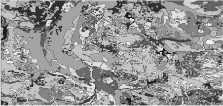
Landscape and landscape-geochemical characteristics, information about relief, actual vegetation and landuse of the territory were used to make a classification of ecosystems for the estimation of the radionuclides migration conditions. According the discussed criteria of the classification, the maps “Carrying out, transport and accumulation of 90Sr and 137Cs” are made by using the landscape map as a cartographic base by means of GIS-tools (Figure 1). The maps show the location of ecosystems with about 20 different types of migration conditions.
375
Fig. 1 Carrying out, transport and accumulation of 90Sr and 137Cs in the ecosystems of 30-km zone of Rivne NPP (fragment):
1 – 3 (green colours) - carrying out (increasing of the process intensity from 1 to 3); 4 – 6 (dark-green colours) - carrying out from river plans ecosystems during a flood; 7 (blue colour) - accumulation and seasonal carrying out from river plans’ ecosystems during a flood; 8 – 10 (yellow colours) - transport; 11 – 18 (pink and red colours) - accumulation; 19 – 21 (yellow-green colours) - primary accumulation and following intensive carrying out.
6. Conclusions
Knowledge about natural laws of substance migration in the environment, expedition and experimental data of landscape structure and landscape-geochemical peculiarities of the territory make it possible to forecast the conditions of 137Cs and 90Sr migration in ecosystems. Our investigation corroborated once more the sensibility of using a landscape base for these prognoses.
The main landscape and landscape-geochemical characteristics, which have to be taken into consideration, are: landforms, soil texture, washing out of soils, soil gleying, quantity of organic matter, regime of humidity of ecosystems, actual vegetation, edaphical conditions.
The maps “Carrying out, transport and accumulation of 90Sr and 137Cs” show ecosystems with a different transfer conditions, including areas of active waterand biogenic accumulation of the contaminants. These potential zones of contamination were recommended to be included into a radioecology monitoring net of the NPP 30km zones.
The results of this investigation can be used for the estimation of migration conditions of radionuclides, other technical pollutants and their complexes as well.
376
7. References
1.Davydchuk V.S., Zarudnaya R.F., Mikcheli S.V. et al. Landscapes of Chornobyl zone and their estimation by migration conditions of the radionuclides. K., Naukova Dumka, 1994. 112pp. (in Russian).
2.Malysheva L.L. Landscape-geochemical mapping of ecological states of territories. Environmental Geochemistry. 3th International Symposium, 12-15 September, 1994. – Krakow, 1994
3.Malysheva L.L. Landscape-geochemical estimation of ecological state of territories. – Kiev: Edditing Centre “Kiev University”, 1997. - 264 p. (in Ukrainian).
4.Perelman A. Geochemistry of Landscapes. M., Vysshaya Shkola, 1975, 342 pp. (in Russian).
5.Sorokina L.Yu. About accumulation of 137Cs by phytocomponents of the forested ecosystems depending the edaphic conditions. Ukrainian Geographical Journal. – 1996, ¹ 1. pp. 44-48. (in Ukrainian).
Part 8.
Possibility of Standardization of
Radionuclides and Chemotoxicants
RADIONUCLIDES 137Cs AND 60Co UPTAKE BY FRESHWATER AND MARINE MICROALGAE CHLORELLA, NAVICULA, PHAEODACTYLUM
M. ŠVADLENKOVÁ
University of South Bohemia, Dept. of Physics, Èeské Budìjovice, CZECH REP.
J. LUKAVSKÝ
Institute of Botany, Academy of Sciences of Czech Republic, Tøeboò, CZECH REP.
J. KVÍDEROVÁ
University of South Bohemia, Dept. of Botany, Èeské Budìjovice, CZECH REP.
1. Introduction
Water plants accumulate to a large extent radionuclides and heavy metals [1, 2]. This fact is used among others for surface water pollution monitoring purposes as well.
It is proved [1, 5] that the radioisotopes of some physiological elements, such as 32P, and furthermore the radioisotopes of those elements such as Co, Y, Fe, Ce, Zr are largely accumulated by water plants. These radionuclides concentration in plants is up to four orders higher than in the ambient water milieu. The radioisotopes of elements,
Cs, Cr, Sr, I, S, Ca, |
are much less accumulated . |
Generally, |
water plants, which have a large effective surface with the |
predominant part |
submerged in water, have a big sorption capacity. These are for |
example water mosses and algae. Here for example, radiocaesium is most accumulated by the microalgae Oocistis elliptica and Oedogonium sp., by the filamentous algae Cladophora sp. and by the moss Fontinalis antipyretica; a big accumulation capacity has the duckweed Lemna minor.
The nature of radionuclide uptake from water by plant can be passive (nonmetabolic) or active (metabolic).
Diffusion, convective flow, physical adsorption and chemical sorption are passive processes. Radioisotopes such as Na, Cl, Ca, Co, Sr, Cs, Ce are partly fixed at certain plants with the help of these processes [6]. Experiments with 137Cs, have shown that the part of it which was fixed on the plant surface is 14% for Zanichellia sp., 46%
for Potamogeton sp., 15% for Myriophyllum sp., 27% for Spirogyra sp., 44% for Cladophora sp. and 36% for Chara sp. [7]. Except for Potamogeton sp., 137Cs is
adsorbed mainly on algae.
The active processes are complex actions the course of which depends, apart from others, on the presence of enzymes. The kinetics of the active transfer can be seen if the modified Langmuire equation developed by Michaelis and Menten is used for the enzymes kinetics [8, 9].
For water plants (as well as for water animals) the uptake capacity of the certain radionuclide depends on a range of factors. The plant species and its vegetation period, the type of radionuclide and its physical-chemical speciation, (radio)activity concentration in water and its time course, mineral composition and
379
F. Brechignac and G. Desmet (eds.), Equidosimetry, 379–387.
© 2005 Springer. Printed in the Netherlands.