

Building Static Model of the Reservoir Questions for Exam
STOIIP Calculations
Abbreviation
for stock-tankoil
initially in place, the volume of oil in areservoirprior
toproduction.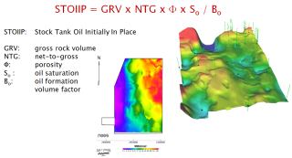
Net to Gross Ratio (N/G)
The N/G is a reservoir parameter of interest for both fluid flow and geologic modelling. N/G is a measure of the amount of sand or pay in the overall reservoir and is used to appraise reservoir quality and the economics associated with reservoir development. The net-to-gross ratio, typically estimated from analogues and wireline logs, also used to calculate the proportion of the sedimentary packages that contains reservoir rocks.
Oil Formation Volume Factor
Oil formation volume factor is defined as the ratio of the volume of oil at reservoir conditions to that at stock tank conditions.
This factor, is used to convert the flow rate of oil at stock tank conditions to reservoir conditions. It is defined as:
B0=Vres/Vsurface [bbl/STB]
Below the bubble point pressure, the oil formation volume factor increases with pressure.
Above the bubble point pressure, the oil formation volume factor decreases as the pressure is increased.
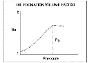
Values typically range from approximately 1.0 bbl/STB for crude oil systems containing little or no solution gas to nearly 3.0 bbl/STB for highly volatile oils.
Water Formation Volume Factor
The produced water formation volume factor (FVF), Bw, is defined as the volume at reservoir conditions occupied by 1 stock tank barrel (STB) of formation water plus its dissolved gas.
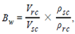
Vrc =volume occupied by a unit mass of water at reservoir conditions, ft3,
Vsc =volume occupied by a unit mass of water at standard conditions, ft3,
ρsc =density of water at standard conditions, lbm/ ft3,
ρrc =density of water at reservoir conditions, lbm/ ft3
Gas Formation Volume Factor
Formation volume factor (FVF) is a useful relationship for relating gas volumes in the reservoir to the produced volume at standard conditions (14.65 psia and 519.67 °R or 60°F).
Bg=Vres/Vsurface
Bg=14.65*T*z/519.67*p
McCain p. 204(dry gas) and p. 247 (wet gas)
Oil saturation
Saturation is the relative amount of water, oil and gas in the pores of a rock, usually as a percentage of volume.
The oil saturation is the fraction of the pore space occupied by oil. Most oil reservoirs also contain some connate water (non-movable) (see water saturation (Sw)). Thus the oil saturation is rarely 100% and usually ranges from 10% to 90% (in the oil / water transition zones). The oil saturation directly affects the calculation of reserves and total compressibility (ct). S=So+Sg+Sw=100%
Water saturation
The water saturation is the fraction of the pore space occupied by water. Most reservoirs are water wet and contain connate water. Water saturation may range from 10% to 50% for an oil or gas reservoir and is 100% for an aquifer. The water saturation obviously affects the oil and gas reserves, and is also used in the calculation of total compressibility (ct).
Determination of Sw:
Sw in wellbores can be determined by the following primary methods:
Sw calculations from resistivity well logs by application of a model relating Sw to porosity, connate-water resistivity, and various rock electrical properties.
Sw calculations from laboratory capillary pressure/saturation (Pc/Sw) measurements by application of a model relating Sw to various rock and fluid properties and height above the free-water level.
Sw calculations using oil-based mud (OBM)-core-plug Dean-Stark water-volume determinations.
Combinations of these methods.
The technique chosen to calculate Sw is often a hybrid that combines the use of two of these basic data sources. For example, the OBM-core Sw data can be used in combination with the resistivity logs to expand the data set used to include all wells and the whole of the hydrocarbon column. Alternatively, the OBM-core Sw data can be used in combination with the Pc/Sw data.
Gas saturation
The gas saturation is the fraction of the pore space occupied by gas. Most gas reservoirs also contain some connate (non-movable) water (see water saturation (Sw)). If the gas reservoir is part of a gas cap in a saturated oil reservoir, the space may contain gas, oil, and water. Thus the gas saturation is rarely 100% but varies from 30% to 90%. Gas saturation is used directly in the calculation of the reserves and also in the calculation of total compressibility (ct). Note that the gas saturation has a significant effect on the total compressibility (ct) since the gas compressibility is much higher than the other fluid compressibilities (oil (co) and water (cw)).
Measured Depth(MD)
The length of the wellbore, as if determined by a measuring stick. This measurement differs from the true vertical depth of the well in all but vertical wells. Since the wellbore cannot be physically measured from end to end, the lengths of individual joints of drillpipe, drill collars and otherdrillstringelements are measured with a steel tape measure and added together.
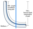
True Vertical Depth(TVD)
True vertical depth is the measurement of a straight line perpendicularly downwards from a horizontal plane.
In the petroleum industry, true vertical depth, abbreviated as TVD, is the measurement from the surface to the bottom of the borehole (or anywhere along its length) in a straight perpendicular line represented by line (a) in the image.
Graph q.9
True Vertical Depth Below Sea Level or Subsea
TVDSS is the vertical distance between the bottom of the well and mean sea level.
Sub-sea depth is the length of the drill string measured from mean sea level to the bottom of the hole. As no well is precisely vertical, TVD must be calculated to account for deviation from vertical and this is why deviation surveys are taken at regular intervals while drilling.
TVDSS is calculated from the sub-sea depth but corrected to account for the cumulative effect of angles of declination in each segment of the well (calculated from deviation surveys shot at set intervals).
Mean See Level(MSL)
Sea level is generally used to refer to mean sea level (MSL), an average level for the surface of one or more of Earth's oceans from which heights such as elevations may be measured. MSL is a type ofvertical datum – a standardised geodetic reference point – that is used, for example, as a chart datum in cartography and marine navigation, or, in aviation, as the standard sea level at which atmospheric pressureis measured in order to calibrate altitude and, consequently, aircraftflight levels. A common and relatively straightforward mean sea-level standard is the midpoint between a mean low and mean high tide at a particular location.
Kelly Bushing(KB)
An adapter that serves to connect the rotary table to the kelly. The kelly bushing has an inside diameterprofile that matches that of the kelly, usually square or hexagonal. It is connected to the rotary table by four large steel pins that fit into mating holes in the rotary table. The rotary motion from the rotary table is transmitted to the bushing through the pins, and then to the kelly itself through the square or hexagonal flat surfaces between the kelly and the kelly bushing. The kelly then turns the entire drillstringbecause it is screwed into the top of the drillstring itself. Depth measurements are commonly referenced to the KB, such as 8327 ft KB, meaning 8327 feet below the kelly bushing.
KB Elevation is the height of KB from the ground surface (for land drilled well) or from mean sea level (for marine well)