

Triangulation
The most common type of geodetic survey is known as triangulation. It differs from the plane survey mentioned earlier in that more accurate instruments are used; instrumental errors are either removed or predetermined so that they can be compensated for in the computations and more rigorous procedures are employed to reduce observational errors. Another very important difference is that all of the positions established by triangulation are mathematically related to each other.
Basically, triangulation consists of the measurement of the angles of a series of triangles. The principle of triangulation is based on simple trigonometric procedures. If the distance along one side of a triangle and the angles at each end of the side are accurately measured, the other two sides and the remaining angle can be computed. Normally, all of the angles of every triangle are measured for the minimization of error and to furnish data for use in computing the precision of the measurements (Figure 7). Also, the latitude and longitude of one end of the measured side along with the length and direction (azimuth) of the side provide sufficient data to compute the latitude and longitude of the other end of the side.
T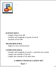 he
measured side of the base triangle is called a base line.
Measurements are made as carefully and accurately as possible with
specially calibrated tapes or wires of invar, an alloy highly
resistant to changes in length resulting from changes in temperature.
The tapes or wires are checked periodically against standard measures
of length (at the Bureau of Standards in the United States and
corresponding agencies in other countries). The geodimeter and
tellurometer, operating on electro-optical and electronic principles
respectively, have replaced the older methods of base measurement in
the recent surveys. The work can be completed more rapidly and
accurately than with wire or tape. The laser equipped geodimeter has
proven to be the most accurate and it can measure much longer
distances without losing accuracy.
he
measured side of the base triangle is called a base line.
Measurements are made as carefully and accurately as possible with
specially calibrated tapes or wires of invar, an alloy highly
resistant to changes in length resulting from changes in temperature.
The tapes or wires are checked periodically against standard measures
of length (at the Bureau of Standards in the United States and
corresponding agencies in other countries). The geodimeter and
tellurometer, operating on electro-optical and electronic principles
respectively, have replaced the older methods of base measurement in
the recent surveys. The work can be completed more rapidly and
accurately than with wire or tape. The laser equipped geodimeter has
proven to be the most accurate and it can measure much longer
distances without losing accuracy.
T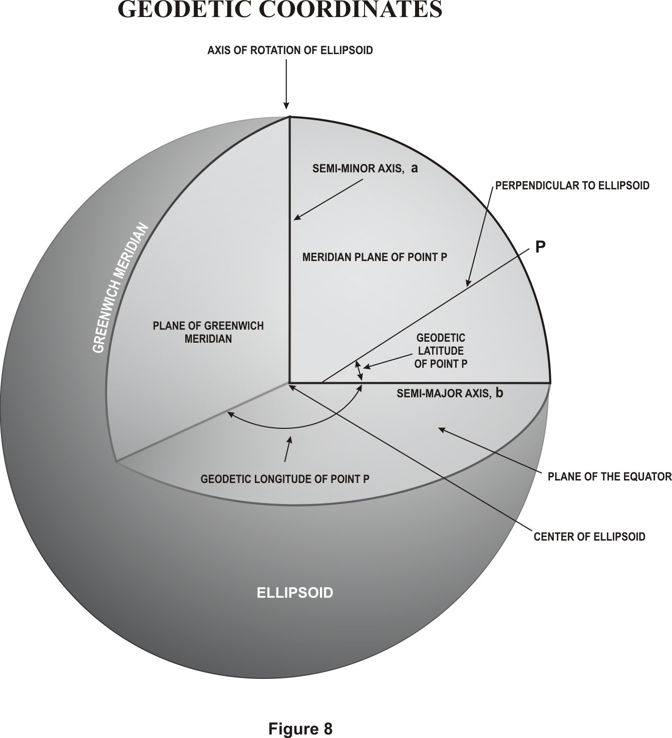 o
establish an arc of triangulation between two widely separated
locations, a base line may be measured and longitude and latitude
determined for the initial point at one end. The locations are then
connected by a series of adjoining triangles forming quadrilaterals
extending from each end (Figure 7). With the longitude, latitude, and
azimuth of the initial points, similar data is computed for each
vertex of the triangles thereby establishing triangulation stations
or geodetic control stations. The coordinates of each of the stations
are defined as geodetic coordinates (Figure 8).
o
establish an arc of triangulation between two widely separated
locations, a base line may be measured and longitude and latitude
determined for the initial point at one end. The locations are then
connected by a series of adjoining triangles forming quadrilaterals
extending from each end (Figure 7). With the longitude, latitude, and
azimuth of the initial points, similar data is computed for each
vertex of the triangles thereby establishing triangulation stations
or geodetic control stations. The coordinates of each of the stations
are defined as geodetic coordinates (Figure 8).
Triangulation is extended over large areas by connecting and extending series of arcs and forming a network or triangulation system. The network is adjusted in a manner which reduces the effect of observational errors to a minimum. A denser distribution of geodetic control is achieved in a system by subdividing or filling in with other surveys. Figure 9 serves to illustrate, in a general manner, the major triangulation networks which have been established.