

Text 1
|
Выражения: | ||
|
be nothing new |
|
не представлять собой ничего нового |
|
be around |
|
находиться/быть рядом |
|
such… as... |
|
такие… как… |
|
both … and … |
|
как… так и… |
|
in practice |
|
в действительности |
|
the way |
|
то, как |
|
call for |
|
требовать |
Introduction
What is geodesy? Who needs it and why? These are some of the questions asked by many people. Actually, geodesy is nothing new having been around for centuries. Webster defines geodesy as "that branch of applied mathematics which determines by observation and measurement the exact positions of points and the figures and areas of large portions of the earth's surface, the shape and size of the earth, and the variations of terrestrial gravity." It is a specialized application of several familiar facets of basic mathematical and physical concepts. In practice, geodesy uses the principles of mathematics, astronomy and physics, and applies them within the capabilities of modern engineering and technology. A thorough study of the science of geodesy is not a simple undertaking. However, it is possible to gain an understanding of the historical development, a general knowledge of the methods and techniques of the science, and the way geodesy is being used to solve some problems.
In the past, geodesy was largely involved with the practical aspect of the determination of exact positions of points on the earth's surface for mapping or artillery control purposes while the determination of the precise size and shape of the earth was a purely scientific role. However, modern requirements for distance and direction call for both the practical and scientific applications of the science to provide the answers to problems in such fields as satellite tracking, global navigation and defensive missile operations.
Text 2
Выражения:
|
be limited to … |
|
сводиться к …, ограничиваться ч-н |
|
immediate vicinity |
|
непосредственная близость |
|
range from … to … |
различаться/изменяться от … до … |
|
|
believe strongly |
|
быть твердо убежденным |
|
in shape |
|
по форме |
|
be widely supported |
|
иметь широкое распространенние |
|
a conservative approximation |
|
осторожное приближение |
|
set out |
задаваться целью |
|
|
at the same time |
|
в то же время |
|
cast a shadow |
|
отбрасывать тень |
|
a currently accepted value |
|
значение, принятое в настоящее время |
|
given above |
|
приведенный выше |
|
for sure |
|
наверняка, точно |
Chapter 1 History of Geodesy
Man has been concerned about the earth on which he lives for many centuries. During very early times this concern was limited, naturally, to the immediate vicinity of his home; later it expanded to the distance of markets or exchange places; and finally, with the development of means of transportation man became interested in his whole world. Much of this early "world interest" was evidenced by speculation concerning the size, shape, and composition of the earth.
The early Greeks, in their speculation and theorizing, ranged from the flat disc advocated by Homer to Pythagoras' spherical figure – an idea supported one hundred years later by Aristotle. Pythagoras was a mathematician and to him the most perfect figure was a sphere. He reasoned that the gods would create a perfect figure and therefore the earth was created to be spherical in shape. Anaximenes, an early Greek scientist, believed strongly that the earth was rectangular in shape.
Since the spherical shape was the most widely supported during the Greek Era, efforts to determine its size followed. Plato determined the circumference of the earth to be 40,000 miles while Archimedes estimated 30,000 miles. Plato's figure was a guess and Archimedes' a more conservative approximation. Meanwhile, in Egypt, a Greek scholar and philosopher, Eratosthenes, set out to make more explicit measurements.
He had observed that on the day of the summer solstice, the midday sun shone to the bottom of a well in the town of Aswan. At the same time, he observed the sun was not directly overhead at Alexandria; instead, it cast a shadow with the vertical equal to 1/50th of a circle (7° 12'). To these observations, Eratosthenes applied certain "known" facts (1) that on the day of the summer solstice, the midday sun was directly over the line of the summer Tropic Zone (Tropic of Cancer) – Aswan was therefore concluded to be on this line; (2) the linear distance between Alexandria and Aswan was 500 miles; (3) Alexandria and Aswan lay on a direct north-south line.
F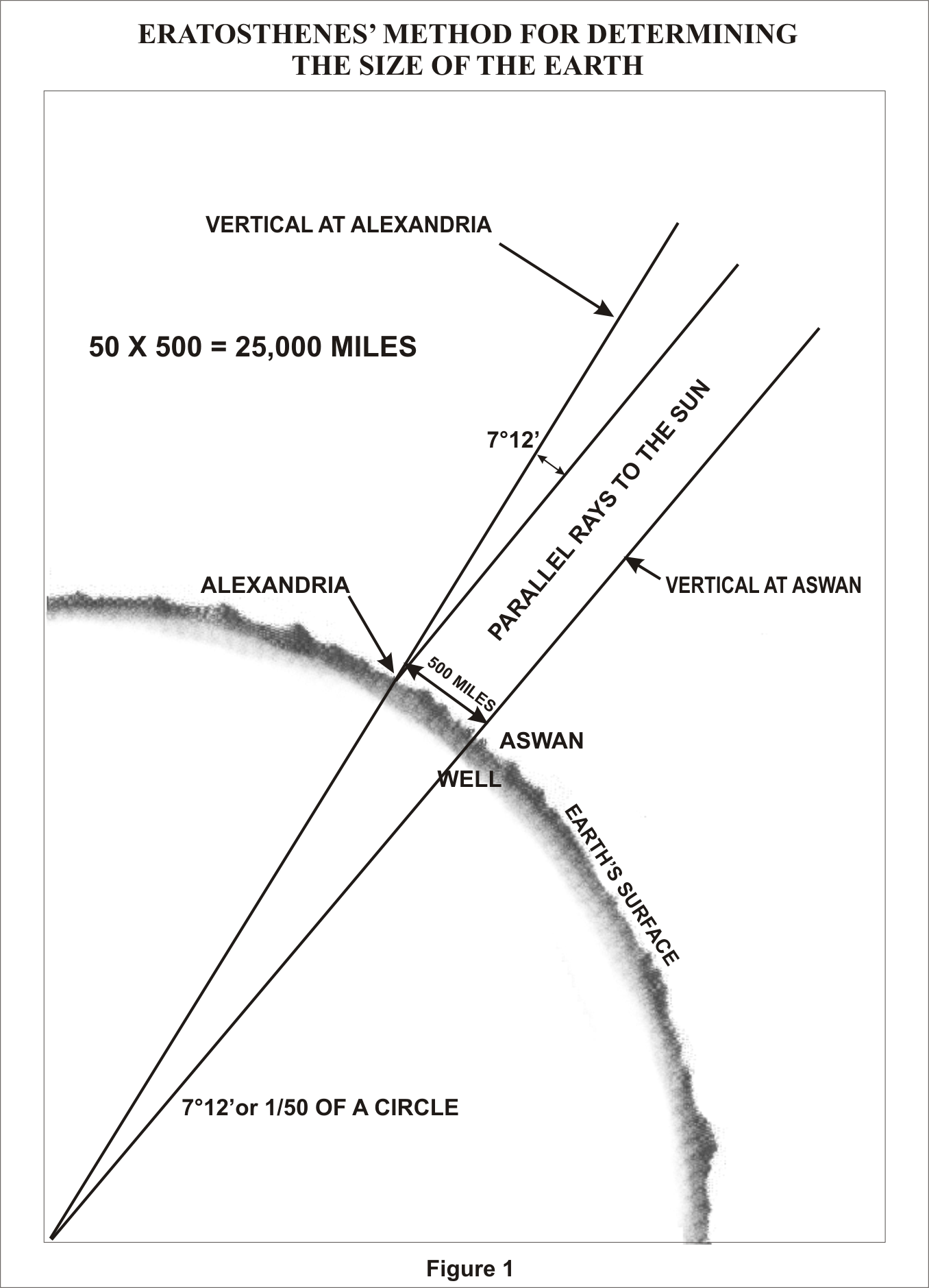 rom
these observations and "known" facts, Eratosthenes
concluded that, since the angular deviation of the sun from the
vertical at Alexandria was also the angle of the subtended arc, the
linear distance between Alexandria and Aswan was 1/50 of the
circumference of the earth or 50 x 500 = 25,000 miles. A currently
accepted value for the earth's circumference at the Equator is 24,901
miles, based upon the equatorial radius of the World Geodetic System.
The actual unit of measure used by Eratosthenes was called the
"stadium." Noone knows for sure what the stadium that he
used is in today's units. The measurements given above in miles were
derived using one stadium equal to one-tenth statute mile.
rom
these observations and "known" facts, Eratosthenes
concluded that, since the angular deviation of the sun from the
vertical at Alexandria was also the angle of the subtended arc, the
linear distance between Alexandria and Aswan was 1/50 of the
circumference of the earth or 50 x 500 = 25,000 miles. A currently
accepted value for the earth's circumference at the Equator is 24,901
miles, based upon the equatorial radius of the World Geodetic System.
The actual unit of measure used by Eratosthenes was called the
"stadium." Noone knows for sure what the stadium that he
used is in today's units. The measurements given above in miles were
derived using one stadium equal to one-tenth statute mile.
Text 3
Выражения:
|
in view of the fact that… |
|
учитывая тот факт, что… |
|
rather than |
|
а не |
|
hidden from view |
|
находящийся вне видимости |
|
the middle ages |
|
средневековье |
|
not until |
только после |
|
|
in the course of |
|
в процессе… |
|
in some respects, |
|
в некотором отношении |
|
by the aid of |
|
с помощью |
|
divide into |
|
делить на |
|
settle the controversy |
|
решить противоречие |
|
once and for all |
|
раз и навсегда |
|
close to |
|
вблизи |
|
in terms of |
|
относительно |