

Geophysical survey methods (after g. Pratt) (2000)
|
Survey method |
Measured parameter |
Physical Property |
Major Applications |
|
Potentials |
|
|
|
|
Gravity |
Spatial variations in the local strength of the gravitational field of the Earth |
Local variations in density |
Mapping of regional structures, sedimentary basins, salt diapers, plutonic intrusions delineation, sand and gravel deposits, depth to bedrock |
|
Magnetics |
Spatial variations in the local strength of the geomagnetic field |
Local variations in susceptibility and remanence |
Mapping of regional structures, airborne surveys, igneous intrusions, sea floor spreading, salt structures, mineral deposits, buried environmental hazards, archeology |
|
Electrical |
|
|
|
|
Resistivity |
Earth resistance (applied voltage / measured current) |
Electrical resistivity (conductivity) |
Mineral prospecting, engineering and hydrogeology, contaminant mapping, construction site investigation, groundwater |
|
Induced polarization (IP) |
Voltage decay, or frequency dependent resistance |
Electrical capacitance |
Detection of disseminated mineral deposits, aquifer mapping, contaminant mapping |
|
Self-potential (SP) |
Natural electric potential |
Electro-chemical activity |
Mineral prospecting, graphite detection, hydrogeology, geothermal studies |
|
Electromagnetic (EM) |
Secondary (induced) electromagnetic fields |
Electrical conductivity and inductance |
Deep mineral prospecting, airborne surveys, conducting faults, groundwater studies, detection of underground pipes and cables, agricultural studies |
|
Ground Penetrating Radar |
Traveltimes, amplitudes, waveforms of reflected electromagnetic pulse |
Electrical conductivity, radar image |
Shallow sedimentary structures, water table detection, bedrock mapping, mapping of hydrocarbon contaminants |
|
Seismic |
|
|
|
|
Earthquake, Microseismic |
Location of earthquake, traveltime of elastic waves |
Compressional, shear velocity, fracture location |
Earth mapping at all scales from global to mine excavation |
|
Refraction |
Traveltimes, amplitudes, waveforms of refracted elastic waves |
Compressional, shear wave velocities |
Crustal scale to engineering scale mapping of rock types, structural boundaries, foundations, hydrogeology |
|
Reflection |
Traveltimes, amplitudes, waveforms of reflected elastic waves |
Compressional, shear wave contrasts, density contrasts, seismic image |
Oil and gas exploration, site surveying, bedrock mapping, detection of shallow faults and cavities. |
Preparing to Drill (4100)
Once the site has been selected, it must be surveyed to determine its boundaries, and environmental impact studies may be done. Lease agreements, titles and right-of way accesses for the land must be obtained and evaluated legally. For off-shore sites, legal jurisdiction must be determined.
Once the legal issues have been settled, the crew goes about preparing the land:
The land is cleared and leveled, and access roads may be built.
Because water is used in drilling, there must be a source of water nearby. If there is no natural source, they drill a water well.
They dig a reserve pit, which is used to dispose of rock cuttings and drilling mud during the drilling process, and line it with plastic to protect the environment. If the site is an ecologically sensitive area, such as a marsh or wilderness, then the cuttings and mud must be disposed offsite -- trucked away instead of placed in a pit.
Once the land has been prepared, several holes must be dug to make way for the rig and the main hole. A rectangular pit, called a cellar, is dug around the location of the actual drilling hole. The cellar provides a work space around the hole, for the workers and drilling accessories. The crew then begins drilling the main hole, often with a small drill truck rather than the main rig. The first part of the hole is larger and shallower than the main portion, and is lined with a large-diameter conductor pipe. Additional holes are dug off to the side to temporarily store equipment -- when these holes are finished, the rig equipment can be brought in and set up.
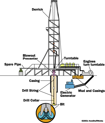
Setting Up the Rig Depending upon the remoteness of the drill site and its access, equipment may be transported to the site by truck, helicopter or barge. Some rigs are built on ships or barges for work on inland water where there is no foundation to support a rig (as in marshes or lakes). Once the equipment is at the site, the rig is set up. Here are the major systems of a land oil rig:
Power system
large diesel engines - burn diesel-fuel oil to provide the main source of power
electrical generators - powered by the diesel engines to provide electrical power
Mechanical system - driven by electric motors
hoisting system - used for lifting heavy loads; consists of a mechanical winch (drawworks) with a large steel cable spool, a block-and-tackle pulley and a receiving storage reel for the cable
turntable - part of the drilling apparatus
Rotating equipment - used for rotary drilling
swivel - large handle that holds the weight of the drill string; allows the string to rotate and makes a pressure-tight seal on the hole
kelly - four- or six-sided pipe that transfers rotary motion to the turntable and drill string
turntable or rotary table - drives the rotating motion using power from electric motors
drill string - consists of drill pipe (connected sections of about 30 ft / 10 m) and drill collars (larger diameter, heavier pipe that fits around the drill pipe and places weight on the drill bit)
drill bit(s) - end of the drill that actually cuts up the rock; comes in many shapes and materials (tungsten carbide steel, diamond) that are specialized for various drilling tasks and rock formations
Casing - large-diameter concrete pipe that lines the drill hole, prevents the hole from collapsing, and allows drilling mud to circulate
Circulation system - pumps drilling mud (mixture of water, clay, weighting material and chemicals, used to lift rock cuttings from the drill bit to the surface) under pressure through the kelly, rotary table, drill pipes and drill collars
pump - sucks mud from the mud pits and pumps it to the drilling apparatus
pipes and hoses - connects pump to drilling apparatus
mud-return line - returns mud from hole
shale shaker - shaker/sieve that separates rock cuttings from the mud
shale slide - conveys cuttings to the reserve pit
reserve pit - collects rock cuttings separated from the mud
mud pits - where drilling mud is mixed and recycled
mud-mixing hopper - where new mud is mixed and then sent to the mud pits
Derrick - support structure that holds the drilling apparatus; tall enough to allow new sections of drill pipe to be added to the drilling apparatus as drilling progresses
Blowout preventer - high-pressure valves (located under the land rig or on the sea floor) that seal the high-pressure drill lines and relieve pressure when necessary to prevent a blowout (uncontrolled gush of gas or oil to the surface, often associated with fire)
|
|
|
|
 Anatomy
of an oil rig
Anatomy
of an oil rig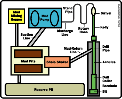 Drill-mud
circulation system
Drill-mud
circulation system