

NVPUB151 - Distances between ports
.pdf2001
PUB. 151
*7642014008470* |
*011* |
NSN 7642014008470 |
ED. NO. 011 |
NIMA REF. NO. NVPUB151 |
|
PUB. 151 DISTANCES BETWEEN PORTS 2001

PUB. 151
DISTANCES BETWEEN PORTS
Prepared and published by the
NATIONAL IMAGERY AND MAPPING AGENCY
Bethesda, Maryland
© COPYRIGHT 2001 BY THE UNITED STATES GOVERNMENT
NO COPYRIGHT CLAIMED UNDER TITLE 17 U.S.C.
ELEVENTH EDITION 2001
For sale by the Superintendant of Documents, U.S. Government Printing Office Internet: bookstore.gpo.gov Phone: toll free (866) 512-1800; DC area (202) 512-1800 Fax: (202) 512-2250 Mail Stop: SSOP, Washington, DC 20402-0001
PREFACE
GENERAL INFORMATION.— The 2001 Edition of Pub. 151, Distances Between Ports, supersedes all previous editions. Distances in this table are in nautical miles based on the International Nautical Mile of approximately 6,076.1 feet. Nautical miles may be converted to statute miles of 5,280 feet by multiplying by 1.15. (See conversion table at back of book). The positions listed for Ports are central positions that most represent each port. The distances are between positions shown for each port and are generally over routes that afford the safest passage. Most of the distances represent the shortest navigable routes, but in some cases, longer routes, that take advantage of favorable currents, have been used. In other cases, increased distances result from routes selected to avoid ice or other dangers to navigation, or to follow required separation schemes.
DESCRIPTION OF THE TABLES.— Departure Ports are listed alphabetically with distances to arrival Ports listed below them; distances to appropriate junction points are also listed. Junction Points are additionally located in the alphabetical sequence with distances to other appropriate Junction Points listed below. Great Lakes distances are given in U.S. Coast Pilot 6.
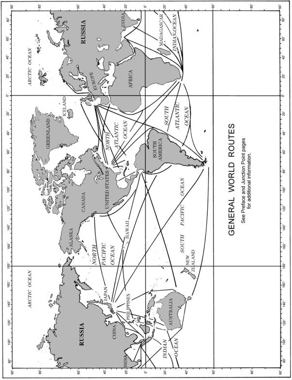
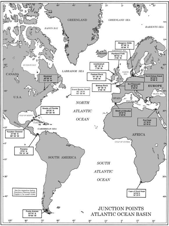
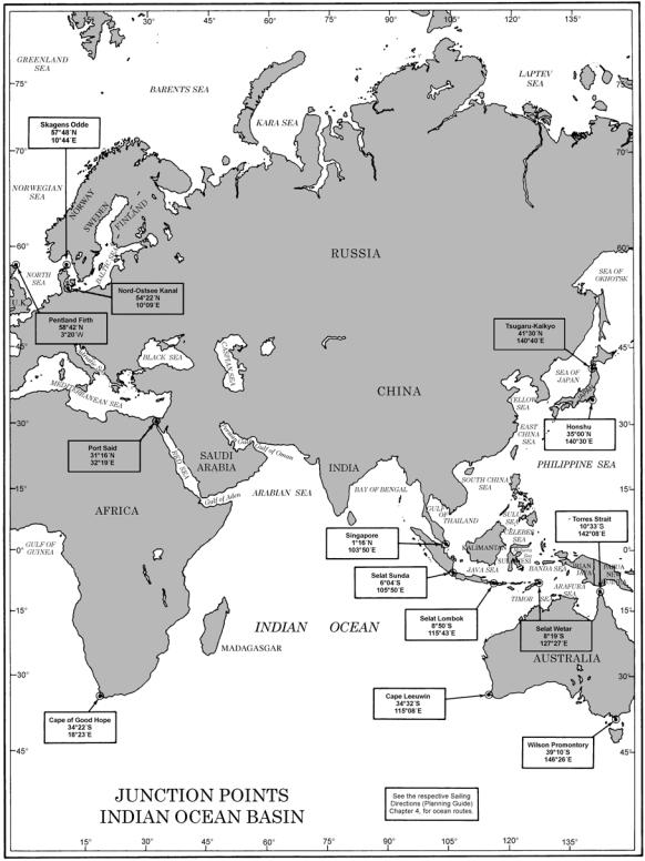
JUNCTION POINTS.— It is impractical to give all distances for every possible combination of Ports in this volume; therefore, the use of Junction Points greatly increases the number of distances that may be included by affording a means of connecting routes in adjacent oceans. In this book a Junction Point is a position where many routes converge and through which ships pass when sailing from one major area into another. For example, the Junction Point for routes from the Atlantic into the Mediterranean is the Strait of Gibraltar. Junction Points used in this publication are shown on the chartlets in the front part of the book.
ROUTES.— Routes throughout the world are described in the Sailing Directions along with route charts for the area of coverage. Articles on currents and meteorology are also covered in these publications. Additionally, charts are available, such as Pilot Charts and the NIMA World Chart, Series 1145, which portray ocean routes worldwide. Any of these products may be used to assist the user in planning a voyage. A chartlet of basic ocean routes is included in the front of this publication for quick reference.
HOW TO USE THE TABLES.— To obtain distances, find the departure port in the alphabetical listing and select the desired arrival port and distance listed below. In most cases, the distances from one port to another and return are reciprocal, but in some cases, the distances differ because different routes were used which
take advantage of favorable currents or weather on one or both of the routes. To obtain a distance over a route that passes through one or more Junction Points, it is necessary to find and add distances for the two or more sections into which the route is divided.
For example: New York to Colombo—Using the Junction Point chartlets at the front of the book, locate all Junction Points between New York and Colombo.
There are two: |
Strait of Gibraltar and |
|
Port Said. |
Find New York in the Distance Table: Page 69 Under Junction Points, locate —
Strait of Gibraltar............. |
3,180 miles |
Find Strait of Gibraltar in the Distance Table:
Page 108
Under Junction Points, locate — |
|
Port Said, Arab Republic of |
|
Egypt................................ |
1,943 miles |
Find Port Said in the Distance Table: Page 85
Under Ports, locate — |
|
Colombo, Sri Lanka.......... |
3,481 miles |
Total Nautical Miles........ |
8,604 |
If the user wishes to know the westbound route because of enroute cargo commitments, or which route is shorter—proceed as follows:
New York to Panama........... |
2,016 |
Panama to Singapore........... |
10,505 |
Singapore to Colombo.......... |
1,581 |
Total Nautical Miles........... |
14,102 |
CORRECTIVE INFORMATION.— Users are requested to forward new or corrective information useful in the correction of this publication to:
MARITIME SAFETY INFORMATION DIVISION ST D 44
NATIONAL IMAGERY AND MAPPING AGENCY 4600 SANGAMORE ROAD
BETHESDA, MARYLAND 20816-5003
I
THE NATIONAL IMAGERY AND MAPPING AGENCY
MARITIME SAFETY INFORMATION WEBSITE
The National Imagery and Mapping Agency (NIMA) Maritime Safety Information Website provides worldwide remote query access to extensive menus of maritime safety information 24 hours a day.
Databases made available for access, query and download include Chart Corrections, Publication Corrections, NIMA Hydrographic Catalog Corrections, Chart and Publication Reference Data (current edition number, dates, title, scale), NIMA List of Lights, USCG Light Lists, WorldWide Navigational Warning Service (WWNWS) Broadcast Warnings, Maritime Administration (MARAD) Advisories, Department of State Special Warnings, Mobile Offshore Drilling Units (MODUs), Anti-Shipping Activity Messages (ASAMs), World Port Index, and Radio Navigational Aids. Publications that are also made available as PDF files include the U.S. Notice to Mariners, U.S. Chart No. 1, The American Practical Navigator (Bowditch), International Code of Signals, Radio Navigational Aids, World Port Index, Distances Between Ports, Sight Reduction Tables for Marine and Air Navigation, Radar Navigation Manual, and the Maneuvering Board Manual.
The Maritime Safety Information Website can be accessed via the NIMA Homepage (www.nima.mil) under the Safety of Navigation icon or directly at http://pollux.nss.nima.mil. Any questions concerning the Maritime Safety Information Website should be directed to:
MARITIME SAFETY INFORMATION DIVISION ATTN: NSS STAFF
ST D 44
NATIONAL IMAGERY AND MAPPING AGENCY 4600 SANGAMORE ROAD
BETHESDA, MD 20816-5003
Telephone: (1) 301-227-3296 or DSN 287-3296
Fax: (1) 301-227-4211
E-mail: webmaster_nss@nima.mil
II
|
CONTENTS |
|
Page |
Preface . . . . . . . . . . . . . . . . . . . . . . . . . . . . . . . . . . . . |
. . . . . . . . . . . . . . . . . . . . . . . . . . . . . . . . . . . . . . . . . . . . . . . . . . . . . .I |
Chart Showing General World Routes . . . . . . . . . . . |
. . . . . . . . . . . . . . . . . . . . . . . . . . . . . . . . . . . . . . . . . . . . . . . . . . . . . V |
List of Junction Points . . . . . . . . . . . . . . . . . . . . . . . . . |
. . . . . . . . . . . . . . . . . . . . . . . . . . . . . . . . . . . . . . . . . . . . . . . . . . . VI |
Junction Points, Atlantic Ocean Basin . . . . . . . . . . . . . |
. . . . . . . . . . . . . . . . . . . . . . . . . . . . . . . . . . . . . . . . . . . . . . . . . . VII |
Junction Points, Indian Ocean Basin . . . . . . . . . . . . . . |
. . . . . . . . . . . . . . . . . . . . . . . . . . . . . . . . . . . . . . . . . . . . . . . . . . VIII |
Junction Points, Pacific Ocean Basin . . . . . . . . . . . . . . |
. . . . . . . . . . . . . . . . . . . . . . . . . . . . . . . . . . . . . . . . . . . . . . . . . . . IX |
Distance Between Ocean Ports of the World . . . . . . . . |
. . . . . . . . . . . . . . . . . . . . . . . . . . . . . . . . . . . . . . . . . . . . . . . . . . . . 1 |
Conversion Table for Nautical and Statute Miles . . . . |
. . . . . . . . . . . . . . . . . . . . . . . . . . . . . . . . . . . . . . . . . . . . . . . . . . 127 |
Table for Estimating Time of Transit . . . . . . . . . . . . . |
. . . . . . . . . . . . . . . . . . . . . . . . . . . . . . . . . . . . . . . . . . . . . . . . . . 128 |
III
V
PUB. 151
JUNCTION POINTS
Bishop Rock, England,................................................................................................49˚45'00"N., 6˚35'00"W. Cape Leeuwin, Australia, ............................................................................................34˚32'00"S,. 115˚08'00"E. Cape of Good Hope, South Africa, .............................................................................34˚22'00"S., 18˚23'00"E. Fastnet Rock, Ireland,..................................................................................................51˚20'00"N., 9˚36'00"W. Grand Banks South,.....................................................................................................42˚30'00"N., 50˚00'00"W. Honshu, Japan, ............................................................................................................35˚00'00"N., 140˚30'00"E. Ile d’Ouessant, France,................................................................................................48˚40'00"N., 5˚30'00"W. Inishtrahull, Ireland, ....................................................................................................55˚25'00"N., 7˚30'00"W. Montreal, Canada, .......................................................................................................45˚30'00"N., 73˚33'00"W. Nord-Ostsee-Kanal, Germany, ....................................................................................54˚22'00"N., 10˚09'00"E. Panama, Panama,.........................................................................................................8˚53'00"N., 79˚31'00"W. Pentland Firth, Scotland, .............................................................................................58˚42'00"N., 3˚20'00"W. Port Said, Egypt,..........................................................................................................31˚16'00"N., 32˚19'00"E. Punta Arenas, Chile,....................................................................................................53˚10'00"S., 70˚54'00"W. Selat Lombok, Indonesia,............................................................................................8˚50'00"S.,115˚43'00"E. Selat Sunda, Indonesia, ...............................................................................................6˚04'00"S., 105˚50'00"E. Selat Wetar, Indonesia, ................................................................................................8˚19'00"S., 127˚27'00"E. Singapore,....................................................................................................................1˚16'00"N., 103˚50'00"E. Skagens Odde, Denmark, ............................................................................................57˚48'00"N.,10˚44'00"E. Strait of Gibraltar,........................................................................................................35˚57'00"N., 5˚45'00"W. Straits of Florida,.........................................................................................................24˚25'00"N., 83˚00'00"W. Torres Strait, Australia, ...............................................................................................10˚33'00"S., 142˚08'00"E. Tsugaru-Kaikyo, Japan,...............................................................................................41˚30'00"N., 140˚40'00"E. Wilson Promontory, Australia, ....................................................................................39˚10'00"S., 146˚26'00"E. Yucatan Channel,.........................................................................................................21˚50'00"N., 85˚03'00"W.
VI
VII
VIII