

- •1.1 System Description
- •1.2 Line Replaceable Units
- •1.3 PFD/MFD Controls
- •1.4 Secure Digital Cards
- •1.5 System Power-up
- •1.6 Display Backlighting
- •1.7 System Operation
- •Normal Mode
- •Reversionary Mode
- •AHRS Operation
- •2.1 Introduction
- •2.2 Backlighting
- •2.3 Softkey Function
- •2.4 Flight Instruments
- •Airspeed Indicator
- •Attitude Indicator
- •Altimeter
- •Vertical Speed Indicator
- •Horizontal Situation Indicator
- •Communication Frequency Window
- •Navigation Frequency Window
- •Navigation Status Bar
- •Transponder Status Bar
- •2.6 Supplemental Flight Data
- •Outside Air Temperature Box
- •System Time Box
- •Traffic Annunciation
- •Terrain Proximity
- •Terrain Awareness and Warning System (TAWS) (Optional)
- •Inset Map
- •Working with Menus
- •Auxiliary Window Keys
- •Auxiliary Windows
- •2.7 Reversionary Mode
- •2.8 Alerts and Annunciations
- •Alerts Window
- •Annunciation Window
- •Softkey Annunciations
- •3.1 Overview
- •Windows and Fields
- •Radio Selection
- •Controls
- •Tuning Box
- •Switching Between Radios
- •Manually Tuning a Frequency
- •Radio Indicators
- •Volume
- •Frequency Transfer Arrow
- •3.2 COM Operation
- •Frequency Spacing
- •Automatic Squelch
- •Selecting a COM Radio
- •Emergency Frequency (121.500 MHz)
- •Quick-Tuning and Activating 121.500 MHz
- •Stuck Microphone
- •3.3 NAV Operation
- •Frequency Range
- •Morse Code Identifier
- •NAV Radio Selection for Navigation
- •ADF/DME Tuning
- •DME Tuning
- •3.4 Frequency Auto-tuning
- •Auto-tuning on the PFD
- •Auto-tuning on the MFD
- •Auto-Tuning on Approach Activation (NAV Frequencies)
- •4.1 Transponder Description
- •Transponder Softkeys
- •Transponder Status Bar
- •Mode S Features
- •Traffic Information Service (TIS)
- •4.2 Operation
- •Mode Selection
- •Code Selection
- •IDENT Function
- •5.1 Audio Panel Description
- •Transceivers
- •Mono/Stereo Headsets
- •Unmuted/Unswitched Inputs
- •Front Panel Controls
- •5.2 Operation
- •Power-up and Fail-safe Operation
- •Key Annunciators
- •Lighting
- •Transceiver Keys
- •Optional COM Muting
- •Split COM Function
- •PA Function
- •Speaker
- •Marker Beacon Receiver
- •Marker Beacon Volume Adjustment
- •Navigation Radios
- •Intercom System (ICS) Isolation
- •Intercom Volume and Squelch
- •Entertainment Inputs
- •GDL 69/69A XM Radio System
- •Master Avionics Squelch (MASQ)
- •Digital Clearance Recorder with Playback Capability
- •Reversionary Mode
- •6.1 Introduction
- •EIS Pages
- •EIS Indicators
- •EiS Page Reversion
- •6.2 Engine Page
- •6.3 Lean Page
- •6.4 System Page
- •7.1 Introduction
- •Description
- •Reversionary Mode
- •Optional Equipment
- •MFD Power-up
- •MFD Backlighting
- •MFD Softkeys
- •Electronic Checklists (optional)
- •MFD Page Groups
- •Working With Menus
- •7.2 Navigation Map Page
- •Navigation Map Page Operations
- •7.3 Traffic Map Page
- •TIS Symbology
- •Traffic Map Page Operations
- •7.4 Terrain Proximity Page
- •Terrain Proximity Page Operations
- •Displaying Obstacle Data
- •Navigation Map Display Conditions
- •Displaying Terrain on the TAWS Page
- •7.6 Direct-to Navigation
- •Direct-to Navigation Operations
- •7.7 Flight Plans
- •Active Flight Plan Page
- •Active Flight Plan Page Options
- •Flight Plan Catalog Page
- •Flight Plan Catalog Page Operations
- •Vertical Navigation (VNAV) Page
- •7.8 Procedures
- •Arrivals and Departures
- •Approaches
- •G1000 Navigational Guidance for Approaches
- •Selecting Approaches
- •7.9 Waypoint Page Group
- •AIRPORT Information Page (INFO)
- •Airport Frequency Information Field
- •AIRPORT Information Page Options
- •Departure Information Page (DP)
- •Arrival Information Page (STAR)
- •Approach Information Page
- •Intersection Information Page
- •NDB Information Page
- •VOR Information Page
- •User Waypoint Information Page
- •Creating User Waypoints
- •Modifying User Waypoints
- •User Waypoint Information Page Options
- •7.10 Auxiliary Page Group
- •Trip Planning Page
- •GPS Status Page
- •System Setup Page
- •System Status Page
- •7.11 Nearest Page Group
- •Navigating to a Nearest Waypoint
- •Nearest Intersections Page
- •Nearest NDB Page
- •Nearest VOR Page
- •Nearest User Waypoint Page
- •Nearest Frequencies Page
- •Nearest Airspaces Page
- •8.1 Introduction
- •8.2 WX-500 Stormscope
- •Displaying Stormscope Lightning Data on the Navigation Map Page
- •Stormscope Page
- •8.3 Traffic Advisory System
- •Displaying and Configuring TAS Traffic on the Navigation Map Page
- •Traffic Map Page
- •Failure Response
- •Description of Traffic Advisory Criteria
- •User-Initiated Test
- •TAS Voice Announcements
- •Switching Between Standby and Various Operating Modes
- •Altitude Display Mode
- •Traffic Map Page Display Range
- •8.4 XM Weather and XM Radio
- •Introduction
- •XM Weather
- •Weather Product Symbols
- •XM Digital Audio Entertainment
- •XM Radio Page
- •9.1 Introduction
- •9.2 Alert Level Definitions
- •9.4 CO Guardian Messages
- •9.6 G1000 System Annunciations
- •Appendices
- •Aviation Database
- •Terrain and Obstacle Databases
- •Introduction
- •TIS vs. TCAS
- •TIS Limitations
- •Airport
- •NAVAIDS
- •Basemap
- •Traffic
- •Lightning Strike
- •Impact Points (TAWS Only)
- •Miscellaneous
- •Line Symbols
- •Obstacle database
- •Terrain Color Chart
- •GMA 1347 Audio Panel
- •GIA 63 Integrated Avionics Units
- •GDC 74A Air Data Computer
- •GTX 33 Mode S Transponder
- •GEA 71 Engine/Airframe Unit
- •GDL 69/69A Weather Data Link
- •GRS 77 AHRS
- •Index

8.4 XM WEATHER AND XM RADIO
INTRODUCTION
The Garmin GDL 69/69A receiver interfaces with the G1000 to bring XM Weather and XM Digital Audio Entertainment to the cockpit. XM Weather and XM Radio operate in the S-band frequency range to provide continuous uplink capabilities at any altitude throughout North America.
IMPORTANT: Before the GDL 69/69A can be used,it has to be activated by XM Satellite Radio. The GDL 69/69A XM Satellite Radio Activation Instructions that were delivered with the aircraft contain important information required to initiate XM satellite radio subscription for the GDL 69/69A.
XM WEATHER
XM weather information is displayed on the following MFD Maps and Pages:
•Navigation Map Page (NEXRAD and XM Lightning only)
•Weather Data Link Page (complete GDL 69 capability)
•Nearest Pages (NEXRAD and XM Lightning only)
•Airport Information Page (NEXRAD and XM Lightning only)
•Flight Planning Maps (NEXRAD and XM Lightning only)
•AUX - Trip Planning Map (NEXRAD and XM Lightning only)
OPTIONAL EQUIPMENT
•Weather Information Page - part of the Waypoint Airport Information Page (METAR and TAF information only)
XM weather information is also displayed on the Primary Flight Display Inset Map. See the G1000 PFD Pilot’s Guide for more information.
NOTE: Temporary Flight Restrictions (TFRs) are displayed on all pages. Radar coverage is always displayed with NEXRAD data.
Complete weather products include the following:
•Graphical NEXRAD Data (NEXRAD)
•Graphical METAR Data (METAR)
•Textual METAR Data
•Textual Terminal Aerodrome Forecasts (TAF)
•City Forecast Data
•Graphical Wind Data (WIND)
•Graphical Echo Tops (ECHO TOP)
•Graphical Cloud Tops (CLD TOP)
•Graphical Lightning Strikes (XM LTNG)
•Graphical Storm Cell Movement (CELL MOV)
•NEXRAD Radar Coverage (displayed with NEXRAD data)
•SIGMETs/AIRMETs (SIG/AIR)
•Surface Analysis including City Forecasts (SFC)
•County Warnings (COUNTY)
•Freezing Levels (FRZ LVL)
•Hurricane Track (CYCLONE)
•Temporary Flight Restrictions (TFR)
190-00498-00 Rev.A |
Garmin G1000 Pilot’s Guide for Cessna Nav III |
8-11 |
OPTIONAL EQUIPMENT
Displaying XM Weather Products on the
Navigation Map Page
The Navigation Map Page displays NEXRAD, Cell
Movement, TFRs, and XM Lightning data.
NOTE: XM Weather products are not displayed at zoom scales less than 10 nm.
NEXRAD
Storms/Legend
NEXRAD
Weather
NEXRAD Softkey
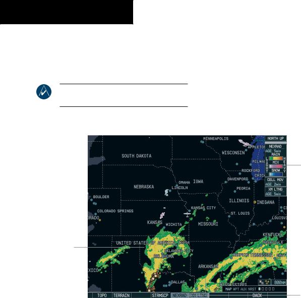
Figure 8-7 Navigation Map Page Displaying NEXRAD Weather
8-12 |
Garmin G1000 Pilot’s Guide for Cessna Nav III |
190-00498-00 Rev.A |
Navigation Map Page Weather Control Softkeys
The following softkeys control the display of NEXRAD and XM Lightning weather products on the Navigation Map Page:
NEXRAD – pressing the NEXRAD softkey displays NEXRAD weather and coverage information. The
NEXRAD option is mutually exclusive with the TOPO,TERRAIN, and STORMSCOPE options, that is, when NEXRAD is activated, TOPO and/or TERRAIN, and/or STORMSCOPE are turned off. XM LTNG – pressing the XM LTNG softkey displays XM lightning information. XM Lightning is mutually exclusive with the STORMSCOPE option.
To display weather data on the Navigation Map Page:
1.Press the MAP softkey.
2.Press the NEXRAD or XM LTNG softkey to display the desired weather. Press the applicable softkey again to remove weather data from the Navigation Map Page.
OPTIONAL EQUIPMENT
Navigation Map Setup Options
The user can customize the display of XM weather on the Navigation Map Page by using the Map Setup Weather Group Options Menu (Figure 8-8). The following options are available:
•NEXRADDATA-TurnsthedisplayofNEXRADdata and radar coverage on or off and selects the desired display range.
•XM LTNG - Turns the display of XM Lightning on or off and selects the desired display range.
•CELLMOVEMENT-Turnsthedisplayofstormcell movement on or off. The Cell Movement option is only shown when NEXRAD is turned on.
Figure 8-8 Map Setup Options
190-00498-00 Rev.A |
Garmin G1000 Pilot’s Guide for Cessna Nav III |
8-13 |
OPTIONAL EQUIPMENT
NOTE: In Figure 8-8, the Stormscope menu options are only shown when the Stormscope unit is installed. Stormscope is not an XM Weather Product.
To customize the Navigation Map Page:
1.Press the Menu key on the Navigation Map Page.
2.Select ‘Map Setup’ and press the ENT key.
3.Turn the small FMS knob to display the group
selection window. Turn the small FMS knob to select the ‘Weather Group’ and press the ENT key.
4.While the Map Setup menu is displayed, turn the large FMS knob to highlight and move between the product selections. When an item is highlighted, turn the small FMS knob to select the desired option and press the ENT key.
Displaying Weather Data on the Nearest Pages
In addition to the Navigation Map Page, the Nearest Pages display Stormscope, NEXRAD, and XM Lightning data.
Displaying METAR and TAF information on the Airport Information Page
METAR and TAF text is displayed on the Airport Information Page when the WX softkey is pressed. Once the WX softkey is pressed the page title changes from ‘WPT - Airport Information’ to ‘WPT - Weather Information’. The METAR data that is displayed is first displayedinadecodedfashion,thentherawtextisdisplayed. TAF information is only displayed in its raw form.
NOTE: METAR is the Aviation Routine Weather Report and is generally standard around the world. The temperatures are given in Celsius degrees. The atmospheric pressure however is reported in hecto pascals everywhere, but the US where the atmospheric pressure is reported in inches of mercury. For aviation purposes the standard temperature and atmospheric pressure are 59° F (15°C) and 28.92 in. Hg (1013.2 hPa).
NOTE:TAF is an airport forecast.TAF is generally standard around the world.TAF forecasts significant weather changes,temporary changes,probable changes and expected changes in weather conditions..
To display METAR and TAF text on the Airport Information Page:
1.Turn the largeFMSknob to select theWPT Page Group.
2.Turn the small FMS knob to select the Airport Information Page.
3.Press theWXsoftkey to display METAR andTAF text (METAR and TAF information is updated every 12 minutes).
8-14 |
Garmin G1000 Pilot’s Guide for Cessna Nav III |
190-00498-00 Rev.A |
Displaying Weather Data on the AUX - Trip Planning Page Map
NEXRAD and XM Lightning Data can be displayed on the AUX - Trip Planning Page Map by pressing the
NEXRAD and XM LTNG softkeys.
Displaying Weather Data on the Flight Plan Page Maps
NEXRAD and XM Lightning Data can be displayed on the Flight Plan Page Maps by pressing the NEXRAD and XM LTNG softkeys.
OPTIONAL EQUIPMENT
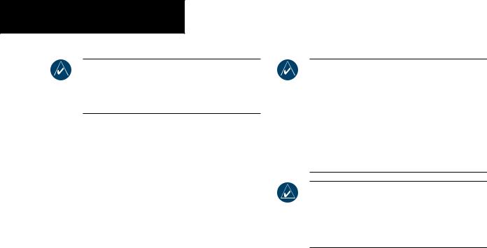
Displaying Weather on the Weather Data Link Page
The Weather Data Link Page displays all available weather products (Figure 8-9). The display of the weather data can either be selected by softkeys located at the bottom of the display or through the Weather Data Link Setup menu.
To select the Weather Data Link Page:
1.Turn the largeFMSknob to select the Map Page Group.
2.Turn the small FMS knob to select theWeather Data Link Page.
Figure 8-9 Weather Data Link Page
190-00498-00 Rev.A |
Garmin G1000 Pilot’s Guide for Cessna Nav III |
8-15 |

OPTIONAL EQUIPMENT
Weather Data Link Page Softkeys
The following softkeys perform the XM Weather functions on the Weather Data Link Page:
NEXRAD – press the NEXRAD softkey to show NEXRAD weather and radar coverage information (both are activated at the same time). Composite data from all of the NEXRAD radar sites in the United States is shown. This data is composed of the maximum reflectivity from the individual radar sweeps. The display of the information is color-coded to indicate the weather level severity. The update rate is every five minutes. Refer to the legend for a description of the color code.
NOTE: WSR-88D weather surveillance radar or NEXRAD (NEXt generation RADar) is a Doppler radar system that has greatly improved the detection of meteorological events such as thunderstorms, tornadoes, and hurricanes. An extensive network of NEXRAD stations provides almost complete radar coverage of the continental United States, Alaska, and Hawaii. The unobstructed range of each NEXRAD is 124 nautical miles.
NEXRAD Abnormalities
There are possible abnormalities regarding displayed NEXRAD images. Some, but not all, of those include:
•Ground Clutter
•Strobes and spurious radar data
•Sunstrobes,whentheradarantennapointsdirectly at the sun
•Interference from buildings or mountains, which may cause shadows
•Military aircraft deploy metallic dust which can cause alterations in radar scans
NEXRAD Limitations
Certain limitations exist regarding the NEXRAD radar displays. Some, but not all, are listed here for the user’s awareness:
•NEXRADbasereflectivitydoesnotprovidesufficient information to determine cloud layers or precipitation characteristics (hail vs. rain, etc).
•NEXRADbasereflectivityissampledattheminimum antennaelevationangle. AnindividualNEXRADsite cannot depict high altitude storms at close ranges, and has no information about storms directly over the site.
•TheresolutionofdisplayedNEXRADdatais2kilometers. Therefore,whenzoomedinonthe display, each square block is 2 kilometers. The intensity levelreflectedbythesquarewillbethehighestlevel sampled within the 2 kilometer square area.
NEXRAD Intensity
Colors are used to identify the different NEXRAD echo intensities (reflectivity) measured in dBZ (decibels of Z). “Reflectivity” is the amount of transmitted power returned to the radar receiver. Reflectivity (designated by the letter Z) covers a wide range of signals (from very weak to very strong). So, a more convenient number for calculations and comparison, a decibel (or logarithmic) scale (dBZ), is used. The dBZ values increase as the strength of the signal returned to the radar increases.
8-16 |
Garmin G1000 Pilot’s Guide for Cessna Nav III |
190-00498-00 Rev.A |
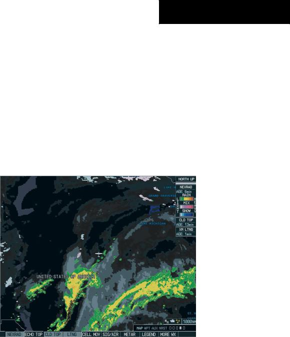
ECHO TOP – press the ECHO TOP softkey to show the location, elevation, and direction of the highest radar echo. This may not indicate the top of a storm or clouds, only the highest radar return echo. The information is derived from NEXRAD information and indicates the highest altitude at which precipitation is falling. ECHO TOPS and Radar coverage are activated at the same time. ECHO TOPS are mutually exclusive from both NEXRAD and CLOUD TOPS, that is, when ECHO TOPS is activated, NEXRAD and CLOUD TOPS are removed. Refer to the Legend for a description of the ECHO TOPS coding. The update rate is every 7.5 minutes.
NOTE: Cloud Tops and Echo Tops use the same color scaling to represent altitude. Turning on both products at the same time is not allowed.
OPTIONAL EQUIPMENT
RADAR COVERAGE – The display of Radar Coverage is always active when NEXRAD and ECHO TOPS are selected and indicates the currently available NEXRAD Radar coverage and ECHO TOPS areas by showing the area in a grayishpurple color where information is not being collected. Areas where radar capability exists, but is not active or is off-line, will not be shown as available. Areas where radar coverage is not available will be shown in grayish-purple. The update rate is every five minutes.
CLD TOP – press the CLD TOP softkey to show the cloud top altitude determined from satellite imagery. Refer to the legend for a description of the CLOUD TOPS color coding. The update rate is every 15 minutes.
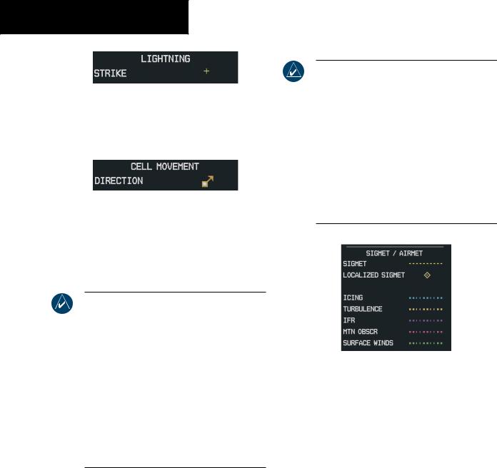
LTNG – pressing the LTNG softkey shows the location of cloud-to-ground lightning strikes. The update rate is every five minutes.
NOTE: Strike location falls within a 2 km region. Therefore, the exact location of the strike is not displayed.
190-00498-00 Rev.A |
Garmin G1000 Pilot’s Guide for Cessna Nav III |
8-17 |
OPTIONAL EQUIPMENT
CELL MOV – pressing the CELL MOV softkey shows the storm cells identified by the groundbased system. The movement is depicted by an arrow. The update rate is every 12 minutes.
SIG/AIR – pressing the SIG/AIR softkey shows SIGMET and AIRMET information to advise the pilot of potentially hazardous weather. The advisory covers an area of at least 3,000 square
miles at any one time. The update rate is every 12 minutes.
NOTE: SIGMETs are broadcast for hazardous weatherthatisconsideredofextremeimportance to all aircraft.SIGMETs (acronym for“SIGnificant METeorological information”) warn of the following weather hazards:severe icing,severe and extreme turbulence, dust storms, sandstorms, or volcanic ash lowering visibility to less than 3 miles. A Convective SIGMET (WST) is issued for hazardous convective weather (such as tornadoes, thunderstorms, hail) and covers severe or great turbulence,severe icing,and low-levelwind shear. AlocalizedSIGMETisasignificantweather condition occurring at a localized geographical position.
NOTE: AIRMETs are broadcast for weather phenomena that potentially affects all aircraft. For pilots of light aircraft, AIRMET (acronym for “AIRman’s METeorological information) gives valuable information about the following conditions: moderate icing, moderate turbulence, sustained winds 30 knots or greater at the surface, widespread area with a ceiling of less than 1,000 feet and/or visibility less than 3 miles and extensive obscurement of mountains. These are important to light aircraft, as they have limited flightcapabilitiesduetolackofequipmentand/or instrumentation.
When enabled, the following AIRMETs can be displayed:
•Icing
•Turbulence
•IFR conditions
•Mountain obscuration
•Surface winds
8-18 |
Garmin G1000 Pilot’s Guide for Cessna Nav III |
190-00498-00 Rev.A |
Refer to the legend for a description of the color coding.
METAR – press the METAR softkey to display METARs (METeorological Aviation Reports). METARS are shown as colored flags at airports providing METAR reports. Refer to the legend for a description of the color code. The update rate is every 12 minutes.
LEGEND – press the LEGEND softkey to display the Weather Legend Window. Turn the small or large FMS knob to scroll up or down through the legend list. Press the small or large FMS knob or the ENT key to remove the legend display. The Weather Legends Window describes the graphic symbols and color coding of the information for each product that is active.
To view the available legends:
1.Press the LEGEND softkey to display the available legends.
2.Turn either the small or large FMS knob to scroll through the legends if more are available than fit in the window.
3.To return to the previous page and remove the legend window,press the LEGEND,ENT,CLR key, or the FMS knob. OR:
OPTIONAL EQUIPMENT
4.On the Weather Data Link Page, press the LEGEND softkey which displays the Page Menu Options. Turn either the large or small FMS knob to select‘Weather Legend’ and press the ENT key.
MORE WX – press the MORE WX softkey to display the following group of softkeys for additional weather control:
NOTE: City Forecast and METAR information is only displayed within the installed Aviation Database service area.
SFC – pressing the SFC softkey for Surface Analysis shows current or forecast conditions. The city forecasts information is combined with the surface conditions. The SFC softkey label changes to reflect the forecast time selected. Forecasts are available for intervals of 12, 24, 36, and 48 hours. The update rate is every 12 minutes.
190-00498-00 Rev.A |
Garmin G1000 Pilot’s Guide for Cessna Nav III |
8-19 |
OPTIONAL EQUIPMENT
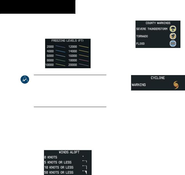
FRZ LVL – press the FRZ LVL softkey to display contour lines for freezing levels. The update rate is every 12 minutes.
NOTE:When no data is shown at a given altitude for any of the weather features,the data for that altitude has not been received or the data is out of date and has been removed from the display. Wait for the next update. The update rate is every 12 minutes.
WIND – press the WIND softkey to show wind speed and direction at a selected altitude from the ground up to 42,000 feet in 3,000 foot increments. The WIND softkey label changes to reflect the winds aloft altitude selected. The update rate is every 12 minutes.
COUNTY – pressing the COUNTY softkey provides specific public awareness and protection weather warnings for Tornado, Severe Thunderstorm, and Flood conditions provided by the National Weather Service (NWS). Refer to the Legend for a description of the county warning icon. The update rate is every 5 minutes.
CYCLONE – pressing the CYCLONE softkey shows the current location of cyclones (hurricanes) and their projected track at various time intervals.
The update rate is every 12 minutes.
Weather Data Link Page Setup
The pilot can customize the display of XM Weather data on the Weather Data Link Page using the Weather Page Options Menu (Figure 8-9).
To customize the display of weather data on the Weather Data Link Page:
1.Press the Menu key on theWeather Data Link Page.
2.Select ‘Weather Setup’ on the Page Menu and press the ENT key.
3.Turn the large FMS knob to highlight and move between the product selections. Turn the small FMS knob to select an option for each selection and press the ENT key.
8-20 |
Garmin G1000 Pilot’s Guide for Cessna Nav III |
190-00498-00 Rev.A |