Геологический словарь ru ang por
.doc
|
Проекция стереографическая – проекция, наиболее часто употребляемая в кристаллографии для плоскостного изображения кристаллографических и оптических направлений в кристалле. Осуществляются с помощью сферы произвольного радиуса из центральной точки кристалла. Грани и ребра кристалла переносятся на сферу путем их непосредственного продолжения до пересечения с поверхностью сферы (грани при этом дают на сфере дуги больших кругов, а ребра – точки). Точки и круги проецируются на горизонтальную плоскость (плоскость проекций), совпадающую с экваториальной плоскостью сферы. Stereographic projection - a projection, the most commonly used in crystallographyfor the planar image of the crystallographic and optical directions in the crystal.Carried out through the sphere of arbitrary radius from the center point of the crystal. Crystal faces and edges are transferred to the sphere by their directextension to its intersection with the surface of the sphere (at the same time give the edge to the field of the arc of large circles, and edges - the point). Dots andcircles are projected onto the horizontal plane (plane of projection), coinciding with the equatorial plane of the sphere.
Projecção estereográfica – é a projeção mais usada em cristalografia para as imagens no plano direcional cristalográfico e ótico no cristal. Realiza-se usando a esfera de raio arbitrário a partir do centro do cristal. Faces de cristal e bordas são transferidos para a esfera através de sua continuação direta à intersecção com a superfície da esfera. Pontos e círculos são projetados em um plano horizontal (o plano de projeção), coincidente com o plano equatorial da esfera. |
|||
|
|
Разрез геологический – графическое изображение на вертикальной плоскости условий залегания горных пород, соотношение горных пород различного возраста и состава, формы геологических тел, их мощности. Разрезы геологические дополняют и уточняют геологическую карту, давая наглядное представление об изменении геологического строения с глубиной. Для составления геологических разрезов используются материалы наземных наблюдений, данные буровые скважин и шурфов. Геологические разрезы строятся в крест простирания (по падению) или под углом к нему (косые разрезы), как правило, в том же масштабе, что и геологическая карта.
G
Corte geográfico – é uma imagem gráfica em um plano vertical de ocorrência da rocha, a proporção de rochas de diferentes idades e composição, forma de corpos geológicos e sua espessura. Cortes geológicos complementam e refinam o mapa geológico, dando uma representação visual da mudança na estrutura geológica com a profundidade. Para a elaboração de cortes geológicos utilizam-se dados de observações terrestres, dados de poços de perfuração e poços de diametros grandes. Cortes geológicos são construídos em uma greve de cruz (em sentido da sobreposição) ou em um ângulo formado com o mesmo (cortes oblíquuos), geralmente na mesma escala que o mapa geológico. |
||
|
Рельеф – совокупность всех форм земной поверхности для каждого конкретного участка и Земли в целом. Relief - the totality of all forms of the earth's surface for each specific site and the Earth as a whole. Relevo – é o conjunto de todas as formas de superfície da terra para cada local específico, e para a Terra como um todo. |
|||
|
Сетки стереографические – стереографические проекции системы меридианов и параллелей, служащие для проецирования кристаллических граней. Существует несколько типов стереографических сеток: сетка Вульфа, сетка Болдырева, сетка Федорова, сетка Шмидта. Stereographic grid - stereographic projections of the system of meridians and parallels serving for the projection of crystal faces. There are several types ofstereographic grid: grid Wolfe grid Boldyrev, net Fedorov, Schmidt net. Rede esteriografica – são projeções estereográficas dos meridianos e paralelos que são essenciais para projetar faces de cristal. Existem vários tipos de redes estereográficas. |
|||
|
|
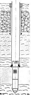
Скважина буровая – цилиндрическая выработка, пройденная буровым инструментом в горных породах земной коры. Начало скважины называется устьем, дно – забоем. Диаметры колеблются от 25 мм до 5 м, могут буриться вертикально вниз, а также под любым углом наклона к горизонту. The bure hole - a cylindrical development, traversed by the drilling tool in the rocks of the crust. Start hole is called the mouth, the bottom - slaughter. Diametersranging from 25 mm to 5 m can be drilled straight down, and at any angle to the horizontal. Poço – é uma escavação cilíndrica feita com a broca de perfuração nas rochas da crosta terrestre. O início do poço é chamado a boca, a parte inferior - o fundo. Diâmetros que variam de 25 mm a 5 m podem ser perfurados verticalmente para baixo, e em qualquer ângulo de inclinação em relação ao horizonte. |
||
|
Съемка геологическая – совокупность всех видов работ по созданию геологической карты местности. Один из основных методов изучения геологического строения какого-либо участка земной коры. Geological surveying - the collection of all types of work to create a geological map of the area. One of the main methods of studying the geology of an area of the crust. Filmagens geológicas – é o conjunto de todos os tipos de trabalho na criação de mapas geológicos. Um dos principais métodos de estudar a geologia de uma área da crostaterrestre. |
|||
|
Уклон – величина, характеризующая наклон прямой к горизонтальной плоскости проекций. Уклон обозначается буквой i и равен тангенсу угла падения. Записывается в виде десятичной дроби или в процентах. Slope - a quantity characterizing the slope to the horizontal plane. The slope is denoted by i and is equal to the tangent of the angle of incidence. Written as a decimal or a percentage. Inclinação – é a inclinação com relação ao plano horizontal. A inclinação é denotada por i e é igual à tangente do ângulo de inclinação. |
|||
|
Числовая отметка – число, выражающее удаление точки от плоскости проекций (плоскости нулевого уровня). Числовые отметки точек, расположенных выше плоскости нулевого уровня, выражаются положительным числом, а отметки точек, расположенных ниже плоскости нулевого уровня, - отрицательным числом. Numerical mark - a number expressing the point of removal from the plane (planezero). Numerical marks the points located above the plane of the zero level,expressed as a positive number, and mark the points located below the plane ofzero - a negative number. Sinal numerico – é o número que representa a supressão de um ponto do plano (plano de nivel zero). As etiquetas numéricas de pontos que estão localizadas acima do plano de nível zero, expressa-se por um número positivo, e as etiquetas numéricas de pontos que estão localizadas abaixo do plano de nível zero, expressa-se por um número negativo. |
|||
|
|
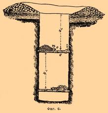
Шурф – вертикальная горная выработка квадратного или прямоугольного сечения, проводимая с поверхности земли при геологической съемке, поисках и разведке месторождений полезных ископаемых Глубина достигает 20-30 м. Pit - a vertical excavation of square or rectangular cross-section, carried out withthe ground surface at the geological survey, exploration and prospecting of mineral deposits depth 20-30m. Poço largo – é uma escavação vertical de seção circular, quadrada ou retangular, feita apartir da superfície errestre no mapeamento geológico, a prospecção de depósitos minerais de profundidade chega a 20 - 30 m. |
||
|
Элементы залегания – азимут падения, простирания и угол падения пласта, определяющие его положение в пространстве. Elements of occurrence - the azimuth of incidence, strike and dip angle, defining its position in space. Elementos de sobreposição – azimute de sobreposição, estiramento, definem a sua posição no espaço. |
|||
|
Элементы складки – части складки: крылья, ядро, замок, осевая плоскость, угол складки, шарнир. Elements of the folds - the folds of: wings, kernel locking, axial plane, the angle of fold hinge. Elementos das dobras – pregas ou dobras, as asas, centro, plano axial, o ângulo de dobra, a dobradiça. |
|||
 eological
cross-section
- a
graphic representation of the vertical plane of occurrence of
rocks, the ratio of rocks of different ages and composition, shape
of geological bodies, their capacities. Geological Cross-sections
complement and refine the geological map, giving a visual
representation of change in the geological structure with depth.
For the preparation of geological sections ofmaterials used
ground-based observations, data drilling wells and pits.
Geological sections are built in cross trend (for fall) or at an
angle to it (oblique sections), usually on the same scale as the
geological map.
eological
cross-section
- a
graphic representation of the vertical plane of occurrence of
rocks, the ratio of rocks of different ages and composition, shape
of geological bodies, their capacities. Geological Cross-sections
complement and refine the geological map, giving a visual
representation of change in the geological structure with depth.
For the preparation of geological sections ofmaterials used
ground-based observations, data drilling wells and pits.
Geological sections are built in cross trend (for fall) or at an
angle to it (oblique sections), usually on the same scale as the
geological map.