Геологический словарь ru ang por
.docГорно-геологический словарь
|
|
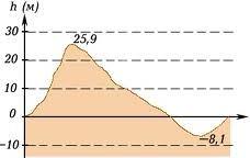
Абсолютная высота – расстояние по вертикали от любой точки поверхности Земли до среднего уровня океана. А.в. точек, лежащих выше этого уровня, считается положительной, ниже – отрицательной. В решении географических, геодезических и геологических задач за расстояние от точки поверхности Земли до среднего уровня океана принимают расстояние от точки до горизонтально расположенной плоскости проекций П0, которую называют плоскостью нулевого уровня. Working face – distance on a vertical from any point of a surface of the Earth to the ocean average level. А.в. The points lying above this level, it is considered positive, more low – negative. In the decision of geographical, geodetic and geological problems for distance from a point of a surface of the Earth to the ocean average level accept distance from a point to horizontally located plane of projections П0 which name a plane of zero level. Altura absoluta – é a distância vertical a partir de qualquer ponto na superfície da Terra até ao nível médio do mar. Os pontos que ficam acima deste nível são considerados positivos, e os que se situão a baixo são considerados negativos. Na resolução de problemas de geográfia, geodésia e problemas geológicos da distância da superfície da Terra ao nível médio do mar, tomasse a distância do ponto até a projecção ( posição ) horizontal do plano de projeção П0, que é chamado o plano de nível zero. |
|
|
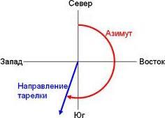
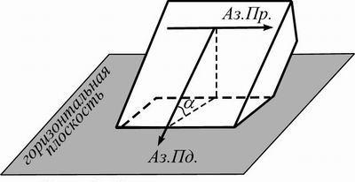
Азимутальный угол – правый угол, отсчитываемый от северного направления меридиана по часовой стрелке до заданного направления. Определяется с помощью компаса, меняется от 0◦ до 360◦. На план и карту проецируется без искажения и измеряется транспортиром. Azimuth – the right corner counted from northern direction of a meridian clockwise to the set direction. It is defined by means of a compass, changes from 0 ◦ to 360 ◦. On the plan and a card it is projected without distortion and it is measured by a protractor. Azimute – ângulo direito, medido a partir da direção norte do meridiano no sentido horário dos ponteiros do relógio para uma direção pré-determinada. Determina-se utilizando uma bússola, varía de 0º a 360º. No terreno e no mapa projeta-se sem distorção e mede-se com o transferidor. |
|
|
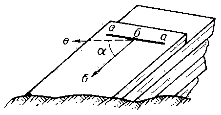
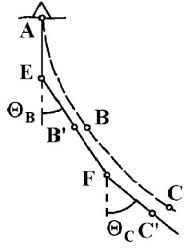
Азимут падения – правый угол между северным направлением меридиана и направлением падения прямой линии или линией падения пласта (слоя толщи, крыла складки). Определяется с помощью горного компаса. Dip azimuth– the right corner between northern direction of a meridian and a direction of falling of a straight line or a line of falling of a layer (a layer of thickness, a fold wing). It is defined by means of a mountain compass. Azimute de sobreposição – é o ângulo direito formado entre a direção norte do meridiano e a direção da queda de uma linha reta ou uma linha do plano (espessura da camada, dobras, asa). Determina-se com o auxílio da bússola de mina. |
|
|
Азимут простирания – правый угол между северным направлением меридиана и линией простирания пласта. Определяется двумя азимутами, отличающимися на 180◦. Практически указывается один из них. Extend azimuth, strike azimuth– the right corner between northern direction of a meridian and a line of prodeleting of a layer. It is defined by two azimuths different on 180 ◦. One of them Practically is underlined.
Azimute de estiramento – ângulo direito formado entre a direção norte do meridiano e o trecho de linha do plano. Determinada por dois diferentes azimutes, diferenciado um do outro em 180º. Na prática indica-se um deles. |
|
|
Бергштрих – короткая черточка, ставится перпендикулярно горизонталям, указывает направление падения. Bergshtrih– the short hyphen, is put perpendicularly to horizontals, specifies a falling direction. Бергштрих – é um traço curto, colocado perpendicular às linhas horizontais, indica a direção de incidência (queda da linha). |
|
|
Блок-диаграмма – геометрическая модель, отражающая соотношение геологических объектов. Часто строится в аксонометрических проекциях. Block chart, block map– the geometrical model reflecting a parity of geological objects. Often is under construction in axonometrical projections. Блок-диаграмма – é um modelo geométrico, o que reflete a relação de objetos geológicos. Muitas vezes construídos em projeção axonométrica.
|
|
Бурение разведочное – бурение скважин с целью разведки месторождений полезных ископаемых, для изучения геологического разреза, а также для получения геофизических данных. Exploratory drilling– drilling of chinks for the purpose of investigation of mineral deposits, for studying of a geological cut, and also for reception of the geophysical data. Бурение разведочное – é a perfuração de poços para a exploração de depósitos minerais, para estudar a secção geológica, bem como para dados geofísicos. |
|


|
|
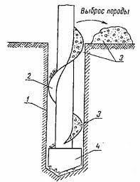
Бурение – проходка буровых скважин. Известно много видов бурения: колонковое, бескерновое, ударное, шнековое и др. Drilling – passing boreholes. Many kinds of drilling are known: core,full-hole, shock, auger, etc. Бурение – afundamento da superficíe terrestre (perfuração). Há muitos tipos conhecidos de perfuração: rosca sem fim, perfuração tubular, percussão, trado, etc |
|
|
|
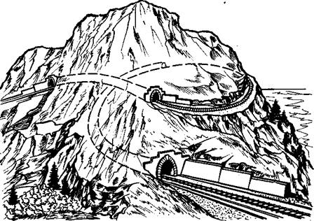
Выработки горные – полости в земной коре, образовавшиеся в результате горных работ в толще полезного ископаемого или в пустых породах. Делятся на открытые, проводимые непосредственно по земной поверхности (карьеры, разрезы), и закрытые, проходимые под поверхностью земли (шурфы, штольни, штреки, квершлаги, орты и др.) Development mountain– cavities in the earth crust, formed as a result of mountain works in thickness of a mineral or in dead rocks. Share on opened, spent directly on a terrestrial surface (open-cast mines, cuts), and the closed earths passed under a surface (pit-hole,adit,drift, cross-cuts, etc.) Выработки горные – cavidades ou escavações na crosta terrestre ou na superficíe rochosa, formada como resultado de operações de mineração na espessura da rocha, mineral ou resíduos. Divide-se em cavidades abertas, realizada diretamente sobre a superfície terrestre ( mina a ceu aberto, cortes), e fechadas, atravessado por de baíxo da superfície da Terra (poços de grande diametro, galerias, pinos, vetores, etc) |
|
|
Горизонтали – линии, соединяющие точки одинаковой высоты, т.е. с помощью горизонталей имеющиеся на топографических картах числовые отметки отображают особенности рельефа поверхности участков земли. (синонимы: изогипсы, линии равных высот). Horizontal – the lines connecting points of identical height, i.e. by means of horizontals numerical marks available on topographic maps display features of a relief of a surface of grounds. (Synonyms: isohypses, lines of equal heights). Horizontais – são linhas que ligam pontos de igual altitude, ou seja, com auxílio destas linhas, em mapas topográficos disponíveis com rótulos numéricos mostram as características de parcelas topográficas da superfície (relevo). (Sinônimos: Изогипсы, são linhas de elevação igual). |
||
|
Градуирование (интерполирование)– определение на проекции прямой точек, отметки которых имеют постоянную разность. Градуирование или графическое интерполирование основано на способе пропорционального деления отрезка прямой линии. Градуирование сводится к определению заложения прямой, соответствующего заданной высоте сечения. Calibration, interpolation– definition on a projection of a straight line of the points which marks have a constant difference. Graduation or graphic интерполирование is based on a way of proportional division of a piece of a straight line. Graduation is reduced to definition заложения by a straight line, section corresponding to the set height. Graduação (Interpolação) – é determinada pela projeção direta de pontos, uma marca que tem uma diferença permanente. Calibração ou método gráfico de interpolação baseado na divisão proporcional de uma linha de segmentos de linha. Calibração se resume como à definição do enterro da linha, correspondendo a uma dada altura da seção. |
||
|
|
Забой – конец горной выработки (штольни, шурфа и др.) или буровой скважины. В процессе горных работ или бурения забой перемещается по намеченному направлению выработки. Working face – the end of mountain development (adit,pit-hole, etc.) or a borehole. In the course of mountain works or drilling the face moves in the planned direction of development. Забой – é o final de escavação ou de um poço (túnel, etc). No processo de mineração ou perfuração move-se na direção da saída pretendida. |
|
|
|
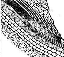
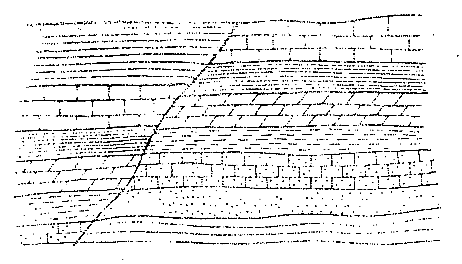
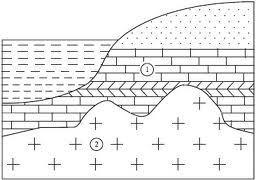
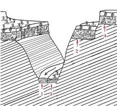
Залегание опрокинутое – возникает в результате интенсивных или длительных тектонических движений. При опрокинутом залегании более древние слои лежат на более молодых и их подошва обращена вверх, а кровля - вниз. The occurrence of inverte – results from intensive or long tectonic movements. At overturned burial more ancient layers lie on younger and their sole is turned upwards, and a roof - downwards. Sobreposição invertida– é o resultado de intensos ou prolongados movimentos tectônicos. Durante o qual as camadas mais velhas sobrepõem-se as mais novas e a sua parte inferior (base ou sola) fica virada para cima, e a parte superior para baixo. |
|
|
|
Залегание первичное – залегание геологических пород, которое они приобретают в процессе своего формирования. Обычно оно близко к горизонтальному. The occurrence of primary – burial geological breeds which they get in the course of the formation. Usually it is close to the horizontal. Sobreposição primária – é o resultado da sobreposição de diferentes rochas geológicas, que elas adquirem no processo de sua formação. geralmente elas são horizontais ou quase horizontais. |
|
|
|
Заложение – длина проекции отрезка прямой, концы которого отстоят по высоте друг от друга на заданную высоту сечения. Заложение и уклон являются величинами обратно пропорциональными друг другу. Location– the length of a projection of a piece of the straight line, which ends will defend on height from each other on the set height of section. Burial and a bias are sizes inversely proportional each other. Extenção – é o cumprimento da projeção de um segmento de reta cujas extremidades são separadas por uma altura de uma extremidade a outra em uma dada altura da seção. Os valores da sobreposição e inclinação são inversamente proporcionais uns aos outros. |
|

|
|
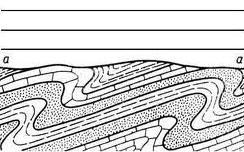
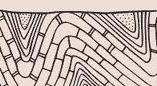
Замок складки – место общего перегиба слоев горных пород в складке, которое разделяет ее боковые части, называемые крыльями. В геометрической модели замок складки рассматривают как криволинейную поверхность (цилиндрическую, коническую, косую плоскость) перехода одного крыла в другое. The fold lock – a place of the general excess of layers of rocks in a fold which divides its lateral parts named wings. In geometrical model the fold lock consider as a curvilinear surface (a cylindrical, conic, slanting plane) transition of one wing in another. Conjunto de dobras – é o lugar de inflexão geral das camadas de rocha (dobra), que separa as partes laterais, que são chamadas de asas. No modelo geométrico das pregas (dobras) são vistos como superfícies curvas (cilíndricas, planas, cônicas e oblíquas) na tranzição de uma asa para outra. |
|
|
|
|
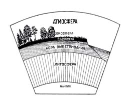
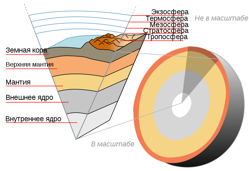
Земная кора — внешняя твёрдая оболочка Земли (геосфера). Ниже коры находится мантия, которая отличается составом и физическими свойствами — она более плотная, содержит в основном тугоплавкие элементы. Разделяет кору и мантию граница Мохоровичича, или сокращённо Мохо, на которой происходит резкое увеличение скоростей сейсмических волн. С внешней стороны большая часть коры покрыта гидросферой, а меньшая находится под воздействием атмосферы. The earth's crust - solid outer shell of the earth (geosphere). Below the crust lies the mantle, which is different composition and physical properties - it is more dense, contains mostly refractory elements. Separates the crust and mantle boundary Mohorovicic, or Moho for short, which is a sharp increase in seismic velocities. From the outside most of the bark is covered with the hydrosphere, and the smaller is exposed to the atmosphere. Superficíe terrestre – é uma camada rígida externa da terra (geosfera). Abaixo da crosta encontra-se o manto, que é de diferente composição e propriedades físicas - é mais denso, contém elementos em sua maioria refratários. De mais a parte externa da casca é coberta com a hidrosfera, e a menor está exposto à atmosfera. |
|
|
|
|
Зенитный угол – угол отклонения оси буровой скважины или горной выработки от вертикали. Antiaircraft corner – a corner of a deviation of an axis of a borehole or mountain development from a vertical. Zenit – é o ângulo de afastamento do eixo do poço ou escavação (tunel) da posição vertical. |
|
|
|
|
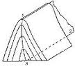
Канава – поверхностная горная выработка трапециевидного, реже прямоугольного сечения, имеющая при значительной длине небольшую глубину и ширину. Канавы задаются с целью вскрытия коренных пород и полезного ископаемого или изучения разреза рыхлых отложений. The ditch – superficial mountain development trapezoid, is more rare than the rectangular section, having at considerable length small depth and width. Ditches are set for the purpose of opening of radical breeds and a mineral or studying of a cut of friable adjournment. Riffle – é uma escavação na superfície de forma trapezoidal, às vezes retangular, com um comprimento considerável de pequena profundidade e largura. Valas são definidas para encostar na rocha e mineral ou a seção de estudo de sedimentos não consolidados. |
|
|
|
Карта геологическая – графическое изображение на топографической карте геологического строения какого-либо участка земной коры. Главным достоинством является ее насыщенность фактическим материалом, структурность, правильное отображение геологического строения изучаемого участка земной коры. Линиями на карте обозначают геологические границы различных пород, слагающих геологические тела. Geological map– a graphic representation on a topographic map of a geological structure of any site of earth crust. The main advantage is its saturation an actual material, correct display of a geological structure of a studied site of earth crust. Lines on a card designate geological borders of the various breeds composing geological bodies. Mapa geográfico – é a imagem gráfica num mapa topográfico da estrutura geológica de qualquer área da crosta terrestre. A sua principal vantagem é a riqueza de material real, mapeamento estrutural correto da estrutura geológica da área estudada da crosta terrestre. Linhas no mapa indicam os limites de diferentes rochas geológicas que formam o corpo geológico. |
|
||
|
|
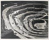
Карьер – эксплуатационная открытая выработка значительных поперечных размеров, служащая для добычи руды, песка, строительных материалов и др. Opencast – operational open development of the considerable cross-section sizes, the employee for extraction of ore, sand, building materials, etc. Mina a céu aberto – é uma chaminé transversal de grandes dimensões, que serve para a extração de areia, minério, materiais de construção, etc. |
||
|
|
|
|
|

|
|
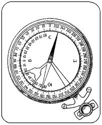
Компас горный – прибор, служащий для определения при геологической съемке элементов залегания геологических тел: азимутов падения и простирания, угла падения. Mountain compass – the device serving for definition at geological shooting of elements burial of geological bodies: azimuths of falling and prodeleting, a hade. Bussula geológica – é um dispositivo de orientação e determinação do mapeamento geológico de elementos do corpo geológico: azinute de incidência e azimute de estiramento , o ângulo de sobreposição. |
|
||||
|
Координаты географические (широта и долгота) – величины, определяющие положение точки на поверхности земли. Coordinates geographical (latitude, longitude) – the sizes defining position of a point on a surface of the earth. Coordenadas geográficas (широта и долгота) – são valores que definem a posição de um ponto na superfície da terra. |
|
|||||
|
Кровля пласта – поверхность, ограничивающая пласт (слой) сверху при его нормальном залегании. Layer roof – a surface limiting a layer (layer) from above at its normal burial. Cobertura da camada – é a camada delimitadora da superfície da terra no topo de sua ocorrência normal ( é a ultima camada da superfície da terra ). |
|
|||||
|
|
Крыло складки – часть складки, где слои имеют односторонний наклон и примерно одинаковые углы падения. В складке выделяются два крыла, связанные замком. Крылья складки представляют собой поверхности, близкие к плоскостям, и могут быть смоделированы двугранным углом. Shank– a fold part where layers have a unilateral inclination and about identical hades. In a fold two wings connected by the lock are allocated. Fold wings represent the surfaces close to planes, and can be simulated a dihedral angle. Asa das dobras – é a parte da dobra (prega) onde as camadas têm a mesma inclinação ou aproximadamente os mesmos ângulos de inclinação. Na dobra tem-se duas asas, ligadas a mesma inflexão (dobra ou prega). |
|
||||
|
|
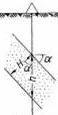
Линия падения – линия, находящаяся в плоскости кровли или подошвы пласта. Она перпендикулярна к линии простирания. Линия падения имеет максимальный угол падения. В технике эта линия называется линией ската, а с точки зрения геометрии это линия наибольшего наклона к горизонтальной плоскости. Любая другая прямая в плоскости, направление которой отличается от направления падения, называется видимым падением. Угол падения такой прямой меньше угла истинного падения. Fall line– a line which is in a plane of a roof or soles of a layer. It is perpendicular to a prodeleting line. The falling line has the maximum hade. In the technician this line is called as a slope line, and from the point of view of geometry it is a line of the greatest inclination to a horizontal plane. Any other straight line in the planes, which direction differs from a falling direction, is called as visible falling. The hade of such straight line is less than corner of true falling. Linha de incidencia – é a linha, localizada no plano ou na camada supeficial da terra. É perpendicular à linha de greve. A inclinação da linha tem o ângulo máximo de inclinação. Em tecnologia, esta linha é uma linha de inclinação, mas em termos geometricos é uma linha de maior inclinação em relação ao plano horizontal. Qualquer outra linha no plano, cuja direção é diferente da direção de inclinação, é chamada declínio visível. O ângulo de inclinação é menor que um ângulo reto da verdadeira inclinação. |
|
||||
|
|
Линия простирания – горизонталь плоскости, линия пересечения структурной плоскости или поверхности с горизонтальной плоскостью. Strike line – a plane horizontal, a line of crossing of a structural plane or a surface with a horizontal plane. Linha de estiramento – é uma linha de intersecção entre um plano ou uma superfície estrutural com o plano horizontal. |
|
||||
|
|
Меридиан - в географии, половина линии сечения поверхности земного шара плоскостью, проведённой через какую-либо точку земной поверхности и ось вращения Земли. Каждый меридиан пересекается со всеми остальными в двух точках на северном и южном полюсе. Meridian - in geography, the half section line of the globe by a plane drawn through any point on the earth's surface and the axis of rotation of the Earth. Each meridian intersects with the other two points on the north and south pole. Meridiano - em geografia, é uma linha de corte de metade do mundo por um avião desenhado através de qualquer ponto na superfície da Terra e o eixo de rotação da Terra. Cada meridiano cruza com os outros dois pontos no norte e no pólo sul. Todos os pontos de um meridiano têm a mesma longitude, mas diferentes latitudes. |
|
||||
|
|
Моноклиналь – геологическая структура, в которой слои наклонены в одну сторону. В качестве геометрической модели может задаваться параллельными плоскостями. Monocline– geological structure in which layers are inclined in one party. As geometrical model it can be set by parallel planes. Моноклиналь – é uma estrutura geológica, na qual as camadas são inclinadas em uma direção. Como o modelo geométrico podem ser definidos planos paralelos. |
|
||||
|
|
Мощность – толщина геологического тела (пласта, слоя, системы). Различают мощность истинную, вертикальную, горизонтальную, видимую. Power - the thickness of the geological body (layer, the layer system). Distinguish the true power, vertical, horizontal, visible. Espessura – é a espessura ou grossura do corpo geológico (camada ou camadas geológicas). Distinguem-se entre espessura real, vertical, horizontal, visível. |
|
||||
|
Мощность вертикальная – расстояние от кровли до подошвы, замеренное в вертикальном направлении. Ми=Мверт*cosα, где α - угол падения пласта. Vertical Power - the distance from the top to the base, measured in the vertical direction.Mи=Mvert*cosα, where α - the corner of dip. Espessura vertical – é a distância do topo a base, medida na direção vertical. Mi = Mvert x cosα, onde α - ângulo de inclinação da camada. |
|
|||||
|
Мощность видимая – расстояние между кровлей и подошвой слоя, измеренное в произвольном направлении. Visible power - the distance between the top and bottom layers, measured in any direction. Espessura visivel – é a distância entre a camada superior e inferior (entre o topo e a base), medido em qualquer direção. |
|
|||||
|
Мощность горизонтальная – кратчайшее расстояние между кровлей и подошвой слоя, измеренное в горизонтальном направлении. Horizontal power - the shortest distance between the top and bottom layers, measured in the horizontal direction. Espessura horizontal – é a menor distância entre a camada superior e inferior (entre o topo e a base), medida na direção horizontal. |
|
|||||
|
Мощность истинная – кратчайшее (по перпендикуляру) расстояние от кровли до подошвы слоя. Power true - the shortest (perpendicular) distance from the top to the base layer. Espessura miníma – é a menor distância (perpendicular) da camada superior a camada inferior. |
|
|||||
|
|
Обнажение – выход горных пород на дневную поверхность. Baring - the output of rocks on the surface. Saída – saída das rochas na superfície. |
|
||||
|
|
Ось складки – биссекторная плоскость двугранного угла, моделирующего складку, проходящая через ребро угла и его биссектрису. Fold axis-the bisector plane of the dihedral angle, simulating a fold that passes through the edge of the angle and its bisector. Eixo das dobras – é a bissetriz do plano do ângulo diedro, modelando o aumento da inflexão passando pela borda do ângulo e sua bissetriz. |
|||||
|
Пласт – геологическое тело, имеющее плоскую форму, при которой его мощность во много раз меньше размеров площади его распространения. Сверху ограничен кровлей, а снизу – подошвой. Как правило, имеет однородный состав. Layer - geological body, which has a flat shape in which its power is much smaller than the area of its distribution. On top of the roof is limited, and bottom - the sole.Usually has a uniform composition. Camada – é um corpo geológico que tem a forma achatada em que sua espessura é muito menor do que a área de sua extenção. Limitado pela parte superior e infeior (topo e base). Como regra geral, tem uma composição homogênea. |
|
|||||
|
Плоскость нулевого уровня – горизонтально расположенная плоскость проекций, от которой отсчитываются абсолютные высоты точек. The plane of the zero level — horizontal plane of projection, from which absolute heights are measured points. Plano de nivel zero – é o plano horizontal de projeção, a partir do qual são medidas as altitudes. |
||||||
|
Поверхность дневная - в геологии условное обозначение поверхности современного рельефа. The surface of the day - in geology reference numbers of modern surfacetopography. Superficié de novo relevo - Em geológia, a condição, simboliza-se como a superfície de relevo moderno. |
||||||
|
Поверхность структурная – геологическая поверхность (например, кровля или подошва пласта), выбранная для изображения на структурной карте. The surface of the structural — geological surface (eg roof or base layer), chosen to represent the structural map. Superficié estrutural – é a superfície geológica (topo ou base da camada rochosa), escolhida para representar no mapa estrutural. |
||||||
|
Подошва – является граничной поверхности слоя в нижней части их нормальное явление (стратиграфически нижней поверхности слоя). Sole - is the boundary surface layer at the bottom of their normal (stratigraphically lower surface layer). Base ou sola – é a camada de superfície delimitadora na parte inferior da sua ocorrência normal (camada superficial estratigraficamente inferior). |
||||||
|
Породы горные – естественные минеральные агрегаты определенного состава и строения, сформировавшиеся в результате геологических процессов и залегающие в земной коре в виде самостоятельных тел. Breed mountain - natural mineral aggregates of a certain composition andstructure, formed by geological processes occurring in the Earth's crust in the form of independent bodies. Rocha – é um agregado de minerais naturais com uma determinada composição e estrutura, formado por processos geológicos e que se depositam na crosta terrestre como um corpo único. |
||||||