

Relationship between thermal evolution of basins, sedimentation and hydrocarbons
Group project on course GL5101 Geodynamics & Plate Tectonics
Authors:
Gendel Danil
Davletova Elena
Kuznetsova Valeria
Makarov Igor
2011
As we know, petroleum geoscience involves variety of studies to provide reliable information about structure of the perspective basin, hydrocarbon potential and maturation history of petroleum play. In spite of operating state-of-the-art machines and precise formulas we always have uncertainty in the end. The answer lies in the intersection of constraining circles of each contributing branch of study. In this project we will try to understand and integrate the role of thermal evolution of basins and subsidence history in formation of hydrocarbons.

Lithogenesis cycle and stages, by Vassoevich, 1983
Basins of passive continental margins
Areas of exploration for new hydrocarbons are changing as the hydrocarbon industry seeks new resources for economic and political reasons. Attention has turned from easily accessible onshore regions such as the Middle East to offshore continental shelves. Over the past ten years, there has been a marked shift towards deep-water continental margins (500–2,500 m below sea level). In these more hostile regions, the risk and cost of exploration is higher, but the prize is potentially enormous. The key to these endeavours is a quantitative understanding of the structure and evolution of the thinned crust and lithosphere that underlie these margins.
One of the most important aim nowadays is to explore virgin areas. On Earth, the largest piece of unexplored continent consists of submerged continental margins that form a ‘fringe’ around the deep ocean basins (Fig. 1).
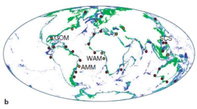


Fig. 1. The distribution of deep-water margins of interest to the hydrocarbon history. Green fringes indicate water depth of 0-500 m, light-blue fringes 500-1500 m and dark blue fringes 1500-2500 m. Solid yellow circles represent current deep-water areas, and solid red circles are frontier deep-water areas. Note the level of activity throughout the South Atlantic Ocean, GOM (Gulf of Mexico), WAM (offshore of West Africa margin), AMM (Amazon margin), SCS (South China Sea).
We describe the geological framework that is used to identify the most prolific margins and to guide the search for deep-water hydrocarbons. We are concerned with the Atlantic Ocean. These extensional margins are the most important locations apart from Southeast Asia for current deep-water exploration, especially a transition zone from thinned continental to oceanic crust, which is a future exploration target.
Identifying prolific margins
There are four prerequisites for a high-quality hydrocarbon system. First, the existence in the margin world-class source rock that has undergone an appropriate degree of thermal maturation. The distribution of suitable organic-rich deposits is strongly dependent upon the development of basins with restricted circulation and upon the location of coastal upwelling zones in ancient times. Second, an adequate supply of sand-rich or carbonate-rich sediment deposited to form suitably porous reservoir rocks. Rivers with large drainage catchments guarantee a substantial input of sand-rich sediment over protracted periods of time. Density underflows transport these sand-rich sediments down the slope onto the abyssal plains. Third, large subsurface structures suitable for trapping billions of barrels of hydrocarbons. Shallow-water exploration has demonstrated the importance of subtler stratigraphic traps, but during the early stages of exploration, large and easily identifiable structures are favoured. Finally, hydrocarbons are less dense than interstitial waters, and so evidence for an unruptured seal, which would prevent buoyant hydrocarbons from leaking out, is needed. The best seals are fine-grained rocks with low permeabilities (for example, mudstones and evaporites).
These four prerequisites limit us to a small set of regions, which currently include the Gulf of Mexico and the West Africa Margin (Fig. 2). In both cases, there is a favourable collocation of high-quality source rock, high sediment input and numerous structures generated by salt or shale deformation at depth.
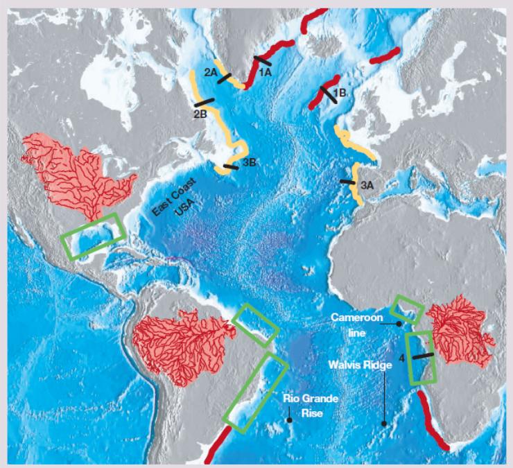
Fig. 2. Margin categories in the Atlantic Ocean. Topography and bathymetry of the region that includes the Atlantic Ocean. In the North Atlantic Ocean, locations of three pairs of combined seismic wide-angle and deep reflection profiles are shown: 1A, B, SIGMA 3 and Hatton Bank surveys; 2A, B Labrador-Greenland survey; 3A, B, Newfoundland and Iberian margin surveys. Red lines show ‘hot’ margins, where large volumes of magma were generated by rifting over a mantle plume. Yellow lines show ‘cold’ margins where there is evidence for exhumation and serpentinization of the lithospheric mantle. The east coast margin of North America is more ambiguous (that is, evidence for some magmatism but no obvious mantle plume). In the central and south Atlantic Ocean, the drainage catchments of the Mississippi, Amazon and Congo rivers are shown as pink and red regions. Two green boxes illustrate zones of deep-water exploration in the Gulf of Mexico and offshore of West Africa. Other green boxes illustrate zones, including the Amazon delta, which has potential for oil production.
When the above prerequisites are in place and when the engineering technology is available, deep-water exploration is an attractive proposition. With increasing water depth and escalating drilling costs, two of the most significant uncertainties are the thermal evolution of the continental margin, which determines the maturation history of a given source rock, and the timing of trap formation. Both uncertainties can be minimized by developing integrated thermal and structural models of margin growth.