

3559
.pdfRussian Journal of Building Construction and Architecture
a) |
|
d) |
|
|
|
|
|
e) |
b) |
||
|
|
|
|
|
f) |
c) |
Fig. 5. Results of training the artificial neural network and identifying the elastic moduli of the pavement layers from the registered bowl of elastic deflections (a––c are the results of training the neural network;
d––f are the results of identifying the elastic moduli of the pavement layers using the artificial neural network and comparing them with the actual values )
The developed artificial neural network was employed as an additional plug-in structural module in the AEM software package. The section of the highway M-1 Belarus, km
90
Issue № 2 (46), 2020 |
ISSN 2542-0526 |
132 + 000–160 + 000, which is in operation, was taken as a test section for idenitfying the elastic moduli of individual layers of the road pavement. A core drill was used to determine the actual thickness of the pavement structural layers. The pavement layers established using it were 20 cm for a package of asphalt concrete layers and 40 cm for a crushed stone base layer by means of the wedge method. The results of identifying the thicknesses of the structural layers of the pavement as well as the bowls of deflections recorded using the FWD PRIMAX 1500 shock loading unit were employed to idenitfy the elastic moduli of the structural layers of non-rigid pavements in this section shown in Table 1.
Table 1
Results of calculating the actual elastic moduli of structural layers of non-rigid pavement on the section of the M-1 highway Belarus, km 160 + 000–132 + 000
Distance, |
Elasticity modulus |
Elasticity modulus |
Elasticity modulus of |
Thickness of an |
Thickness of an |
m |
of asphalt concrete – |
of the foundation – |
thesubgradesoil– |
asphalt concrete |
asphalt concrete |
|
E1, МPа |
E2, МPа |
E3, МPа |
layer – Н1, mm |
layer – Н2, mm |
|
|
|
|
|
|
0 |
1199 |
223 |
105 |
200 |
400 |
|
|
|
|
|
|
3595 |
1722 |
146 |
143 |
200 |
400 |
|
|
|
|
|
|
4774 |
1914 |
129 |
108 |
200 |
400 |
|
|
|
|
|
|
7386 |
1736 |
104 |
185 |
200 |
400 |
|
|
|
|
|
|
7805 |
1556 |
279 |
142 |
200 |
400 |
|
|
|
|
|
|
9757 |
1570 |
139 |
102 |
200 |
400 |
|
|
|
|
|
|
10 638 |
2105 |
344 |
204 |
200 |
400 |
|
|
|
|
|
|
11 253 |
2248 |
227 |
157 |
200 |
400 |
|
|
|
|
|
|
13 085 |
1709 |
257 |
81 |
200 |
400 |
|
|
|
|
|
|
17 318 |
1719 |
285 |
113 |
200 |
400 |
|
|
|
|
|
|
18 666 |
877 |
123 |
85 |
200 |
400 |
|
|
|
|
|
|
21 065 |
1283 |
153 |
196 |
200 |
400 |
|
|
|
|
|
|
23 511 |
2314 |
201 |
135 |
200 |
400 |
|
|
|
|
|
|
24 856 |
2427 |
141 |
154 |
200 |
400 |
|
|
|
|
|
|
The analysis of the obtained results shows a decrease in the modulus of elasticity of the package of layers of asphalt concrete relative to the normative values regulated by the current regulatory documents Design Standards for Industrial Roads (ОДН) 218.046-01 “Design of Flexible Road Pavements” and Preliminary National Standards (ПНСТ) 265-2018 “Design of Non-Rigid Pavements”. In this case the values of the elasticity moduli of the structural layers of the foundation and the subgrade soil as a whole correspond to the standard values. Indirectly, a decrease in the modulus of elasticity of asphalt concrete layers in this area is confirmed by the results of core sampling of asphalt concrete layers. Thus, e.g., 70 % of the samples ta-
91

Russian Journal of Building Construction and Architecture
ken in the lower layer of the pavement and the upper layer of the base made of asphalt concrete in this area have cracks and stratification, which indicates the adequacy of idenitfying the elastic moduli of asphalt concrete layers set up during non-destructive testing using artificial neural network algorithms. The obtained data can be used in the development of projects for repairs and overhauls on operated highways as well as in substantiating a strategy for ensuring the safety of non-rigid road pavements.
Conclusions.
––A neural network has been developed and trained for identifying the elastic moduli of structural layers of non-rigid road pavements based on the results of instrumental recording of bowls of elastic deflections using a modern FWD shock loading unit, which provides an increased speed and stability of calculations in comparison with traditional software systems supplied with FWD shock loading units.
––The resulting neural network showed excellent results during training on the test dataset (the coefficient of determination was R2 = 0.97) as well as a high accuracy in identifying the elastic moduli of road pavements layers compared with the calculated results of standard software systems (the coefficient of determination was R2 = 0.95)
––The results of calculating the elasticity moduli of the structural layers of non-rigid road pavements on the operated section of the M1 “Belarus” highway have been presented. The actual values of the elastic moduli of individual layers of non-rigid road pavements were identified based on the algorithms for processing an artificial neural network which can be employed in the development of projects for small and major repairs of operated highways as well as in substantiating a strategy for ensuring the safety of non-rigid road pavements
––The investigated neural network can be modernized in order to address the problem of identifying the elastic moduli of three or more layered systems while providing a high speed and accuracy, which is critical for processing large data sets on deflection bowls recorded in long sections of highways.
References
1.Bogoslavskii S. N. Oblast' primeneniya iskusstvennykh neironnykh setei i perspektivy ikh razvitiya [Scope of artificial neural networks and prospects for their development]. Politematicheskii setevoi elektronnyi nauchnyi zhurnal Kubanskogo gosudarstvennogo agrarnogo universiteta, 2007, no. 27, pp. 1––11.
2.Vasenkov D. V. Metody obucheniya iskusstvennykh neironnykh setei [Training methods for artificial neural networks]. Komp'yuternye instrumenty v obrazovanii, 2007, no. 1, pp. 20––29.
3.Voronovskii G. K. Geneticheskie algoritmy, iskusstvennye neironnye seti i problemy virtual'noi real'nosti
[Genetic algorithms, artificial neural networks, and virtual reality problems]. Kharkov, Osnowa Publ., 1997. 107 p.
92
Issue № 2 (46), 2020 |
ISSN 2542-0526 |
4.Tiraturyan A. N., Uglova E. V. Programmnyi kompleks dlya «obratnogo» rascheta dinamicheskikh modulei uprugosti ekspluatiruemykh dorozhnykh konstruktsii s uchetom parametrov vozdeistviya ustanovok nagruzheniya dorozhnykh odezhd [Software package for "reverse" calculation of dynamic elastic modulus of road structures in use, taking into account the parameters of the impact of road surface loading installations]. Internetzhurnal Naukovedenie, 2012, no. 3 (12), pp. 143––150.
5.Khaikin S. Neironnye seti: polnyi kurs, 2-e izdanie [Neural networks: a complete course, 2nd edition]. Moscow, Izdatel'skii dom Vil'yams, 2008. 1104 p.
6.Yakh"yaeva G. E. Nechetkie mnozhestva i neironnye seti [Fuzzy sets and neural networks]. Moscow, Binom Publ., 2006. 316 p.
7.Alavi S., LeCates J. F., Tavares M. P. Falling weight deflectometer usage. 2008. NCHRP report, Project no. 20-5, 137 p.
8.Alkasawneh W. M. Backcalculation of pavement moduli using genetic algorithms. Ohio, University of Akron, 2007. 275 p.
9.Öcal A. Backcalculation of pavement layer properties using artificial neural network based gravitational search algorithm. Middle East Technical University, Ankara, 2014. 181 p.
10.Doré G., Zubeck H. K. Cold regions pavement engineering, 2009. 240 p.
11.Harichandran R. S. Modified Newton algorithm for backcalculation of pavement layer properties. Transportation Research Record, 1993, vol. 1384, pp. 15––29.
12.Hassan H. F., Mousa R. M, Gadallah A. A. Comparative analysis of using AASHTO and WESDEF approaches in back-calculation of pavement layer moduli. Journal of transportation engineering, 2003, vol. 129, no. 3, pp. 322––329.
13.Mahoney J. P. Some observations about backcalculation and use of a stiff layer condition. Transportation Research Record, 1993, no. 1384, pp. 8––14.
14.Saltan M., Terzi S., Küçüksille E. U. Backcalculation of pavement layer moduli and Poisson’s ratio using data mining. Expert Systems with Applications, 2011, vol. 38, no. 3, pp. 2600––2608.
15.Elshamy M. Application of Artificial Neural Network System to Predict Pavement Condition Index. Master Dissertation, Al Azhar University, Egypt, 2016. P. 175.
16.Meier R. W., Rix G. J. Backcalculation of flexible pavement moduli using artificial neural networks. Transportation research record, 1994, no. 1448, pp. 75––82.
17.Rohde G. T. MODULUS 4.0: Expansion and validation of the MODULUS backcalculation system. Texas, Texas Transportation Institute, 1990. 128 p.
18.Schmalzer P. Long-Term Pavement Performance Program Manual for Falling Weight Deflectometer Measurements, Version 4.1, Report No: FHWA-HRT-06-132 4. 79. Washington, FHWA –– 2006. 225 p.
19.Ullidtz P., Stubstad R. N. Analytical-empirical pavement evaluation using the falling weight deflectometer. Transportation Research Record, 1985, vol. 1022, pp. 36––44.
20.Sharma S., Das A. Backcalculation of pavement layer moduli from falling weight deflectometer data using an artificial neural network. Canadian Journal of Civil Engineering, 2008, vol. 35, no. 1, pp. 57––66.
21.Ceylan H. Backcalculation of full-depth asphalt pavement layer moduli considering nonlinear stressdependent subgrade behavior. International Journal of Pavement Engineering, 2005, vol. 6, no. 3, pp. 171––182.
93

Russian Journal of Building Construction and Architecture
CITY PLANNING,PLANNING OF VILLAGE SETTLEMENTS
DOI10.36622/VSTU.2020.2.46.007
UDC711.16:504.75
V. А. Ilyichev1, V. I. Kolchunov2, G. A. Ptichnikova3, A. A. Kormina4
URBAN ENVIRONMENT DESIGN: NEW METHODOLOGICAL APPROACHES BASED ON THE BIOSPHERE COMPATIBILITY PARADIGM (PART 1)
Russian Academy of Architecture and Construction Sciences (RAACS)1
Russia, Moscow
Southwest State University2
Russia, Kursk
Scientific Research Institute of Theory and History of Architecture and Urban Planning (NIITIAG)3
Russia Moscow
Southwest State University4
Russiа, Kursk
1 Аcademician of RAACS, D. Sc. in Engineering, Prof., e-mail: ilyichev@raasn.ru 2 Аcademician of RAACS, D. Sc. in Engineering , Prof., e-mail: asiorel@mail.ru
3 Member-correspondent of RAACS, D. Sc. in Achitecture , Prof., e-mail: ptichnikova_g@mail.ru, 4 PhD student, e-mail: sascha-girl@mail.ru
Statement of the problem. The question is raised about the need to develop methodological approaches to urban planning at the microterritorial level, aimed at creating a comfortable and safe environment for life in cities and settlements.
Results. The authors propose a methodology development project development plan for the area –– planning documentation the town-planning elements of planning structure (blocks, neighborhoods, residential areas) based on the developed in RAACS paradigm of biosphere compatibility of cities and settlements that develop the man. The method of evaluating variants of planning projects based on a comparison of four blocks of indicators: environmental safety of residential areas, spatial and territorial resources, structural planning and architectural organization of the territory and provision of urban functions. For each of these blocks, the necessary and sufficient composition of indicators is determined, which are calculated based on the design solutions. The prospects for the development of quantitative evaluation of design solutions using the principles of the biosphere compatibility paradigm at the microterritorial level are shown.
Conclusion. The numerical evaluation of the design solutions shows the social content of the territory planning projects and reflects the decisions on the urban environment of the city.
Keywords: urban planning design; evaluation of design solutions; design methodology; territory planning project; paradigm of biosphere compatibility of cities and settlements that develop people, comfortable and safe environment of the city.
Introduction. Currently the task of forming a comfortable and safe urban environment requires development of new guidelines for its design, changes in the design methodology of territorial planning projects. [1, 2, 4].
© Ilyichev V. А., Kolchunov V. I., PtichnikovaG. A., Kormina A. A., 2020
94
Issue № 2 (46), 2020 |
ISSN 2542-0526 |
It is the planning project of the area of functional planning residential formations or residential planning units (district, microdistrict, quarter, etc.) that is the type of urban planning documentation where the characteristics of the quality of an urban environment are identified.
The aim of the article is to reveal the possibilities of urban planning with a qualitatively new approach in relation to a detailed (micro-territorial) level of documentation, which refers to the planning elements of the structure of a city (quarter, microdistrict, residential area) considering the continuity of the existing urban planning methodology.
The issue of interaction of urban planning structures with the natural environment was the focus of studies by domestic and foreign scientists. In our country, these are the works of V. V. Vladimirov [3], N. F. Reimers [10], S. B. Chistyakov [11––12]. These issues were investigated by such scholars overseas such as H. Barton, M. Grant [18], P. Hall, W. Pfeifer [20], J. Birch [19].
Most of the studies by V. V. Vladimirov were dedicated to the study of the interaction of the city and natural structures at the macroand mesoterritorial levels. At the same time, he outlined the ways of developing methods of urban environment for the microterritorial level. V. V. Vladimirov argued that “the micro-territorial level is distinguished by the great concreteness of the measures being developed to improve the urban environment <...>. Urban environmental research at this level is mostly based on urban planning, hygienic and technological methods” [3].
This kind of research is currently ongoing in this country aiming to develop mechanisms for assessing design solutions from the standpoint of designing a safe and comfortable living environment. As part of fundamental interdisciplinary research at the RAASN run by Academician V. A. Ilychev, a new paradigm of life was developed for man-made biospherecompatible cities and settlements [5]. The sequence of the paradigm principles establishes priorities and a hierarchy of concepts, identifies issues in the organization of city life, allows one to calculate the level of symbiotic relations between the city and nature as well as to quantify the opportunities provided by the city for the development of its residents. The principles of the paradigm involve obtaining measurable results, which are a measure of achieving a goal, i.e., the biosphere compatibility of the city, reflecting the level of implementation of specific urban planning measures. Biosphere compatibility of a city is a state of symbiosis between the city and the surrounding biosphere where the city and its residents are experiencing a positive development with the biosphere retaining its ability to naturally evolve in a certain region. In fact, it is not only about “natural development in harmony with a natural envi-
95

Russian Journal of Building Construction and Architecture
ronment, but also about the restoration of the biosphere undermined in the process of urbanization of the territory".
In the studies by the Academician of the RAASN M. V. Shubenkov the features of the formation of sustainable urban systems are defined and modern approaches and methods for predicting their spatial development are outlined [15–17].
Hence the domestic urban planning science has a huge potential in regards to addressing environmental problems in urban planning activities, particularly the upper levels of design –– territorial planning schemes, general plans. At the same time, currently the task of forming a comfortable and safe urban environment requires ongoing research that develops scientific and methodological approaches to designing an urban environment at the micro level, which will allow an objective assessment of design solutions at the stage of choosing a particular option of a planning project.
1.Territory planning project as a document defining the quality of the urban environment. A territory planning project (TPP) in compliance with Section 42 "Urban Planning Code of the Russian Federation" from December 29, 2004 N 190-FZ (modified on 08/02/2019) (amended and supplemented, came into force on August 13, 2019) is performed in order to highlight the elements of the planning structure, establish the boundaries of common areas as well as the zones of the planned location of major construction objects, identify the characteristics and priority of the planned development of the area. It is at this level that the fundamentals of the living environment of such planning formations of contemporary Russian cities as a residential area or microdistrict are laid. Thus, a project for the planning of the territory of functional planning residential structures or residential planning units is the type of urban planning documentation that identifies the characteristics of the quality of the urban environment of a future district.
Detailed regulatory information on the design of the residential environment of the city in the implementation of territorial planning projects is provided in the Code of Regulations SP 42.13330.2016 "Urban Planning, Planning and Development of Urban and Rural Settlements" in various sections, e.g., 5. Residential Areas, 6. Public and Business Areas, etc. Normative indicators are linked to individual urban subsystems (housing, services, transport, etc.), which is a characteristic feature of the functional approach to city design with rigid monozoning of its area.
2.Proposals for improving the design methodology for developing planning projects for residential areas using the paradigm of biosphere compatibility. The design method
96
Issue № 2 (46), 2020 |
ISSN 2542-0526 |
adopted in Russian urban planning practice regulates implementation of “variants of planning and (or) volumetric-spatial solutions for developing territories in accordance with a project of business zones)” (Section 4.9, Article 42 of the Civil Code of the Russian Federation). In order to justify the decisions in the TPP, several options for draft architectural and planning proposals for developing the territory are being designed. Options of design solutions can be reduced to both alternative design concepts of a residential area, or a microdistrict, and to relatively identical design solutions differing in the number and location of individual objects, development of a system of pedestrian paths, construction of sports and playgrounds, parking lots, landscaping, up to small architectural structures. For each version of a draft architectural and planning proposal, a graphic and a textual parts are prepared (an explanatory note containing the basic concept of the spatial development of the territory, justification of the correspondence of the designed sketch to the guidelines of a particular task, etc.).
In order to compare the options in the planning projects for the territory of functional planning residential formations at the stage of selecting a viable design solution and assessing the degree of comfort and safety of the living environment, a methodological approach using the consistent implementation of the provisions of the biosphere compatibility paradigm is suggested.
1.Environmental safety of each and every resident;
2.Strategic planning, i.e., analysis of problems and development of solutions for improving the city’s livability;
3.Designing a favorable and comfortable living environment for each and every resident;
4.Environmental, social, technical safety of the city.
If all of the provisions of the paradigm are performed in stages, we have a safe man-made living environment. A distinctive feature of the above approach is the premises that the urban environment is considered a single territorial space characterized by a specific state of bio-, socioand technospheric components critical to creating conditions for the development of an “individual” but not a “territory”. Thus, the choice of indicators related to an individual, residents, people will be made.
Let us consider an algorithm for the variant assessment of design solutions in relation to residential areas where almost 65 % of residents live daily. In accordance with the above provisions of the paradigm of biosphere compatibility four blocks of indicators for assessing options for design solutions are to be identified while developing planning projects for residential areas:
Block 1. Environmental safety of residential areas (Regulation 1); Block 2. Spatial and territorial resources (Regulation 3);
97

Russian Journal of Building Construction and Architecture
Block 3. Structural and planning organization of the territory (Regulation 3); Block 4. Urban functions (Regulation 3).
For each of these blocks, the authors propose indicators that are calculated according to design decisions. Based on the comparison of indicators, an appropriate version of the planning project is selected.
This article discusses in detail the content and methodology for quantifying the indicators of the first three blocks. The block of indicators for assessing provision of urban functions will be considered in the second part of the publication.
3. Assessment of the environmental safety of residential areas. The indicators of this block are developed based on the dualistic principle 2 "On the Comparison of Two Directions in the City’s Activities" of the paradigm of biospheric compatibility of man-made cities and settlements [5]. In the urbanized environment dualism is external, i.e., the impact of the city on nature, and internal, i.e. the level of physical and social health of the population. The level of health of the urban population is one of the implications of the direct and indirect human impact on the natural environment.
In order to assess the environmental safety of residential areas for the corresponding block by the same name, the following indicators are suggested:
––“the environmental rank of the surrounding area corresponding to the administrative “level” of a particular city”;
––“correlational links between medical and demographic and environmental characteristics of the territory”.
The environmental rank is a complex indicator reflecting the level of environmental wellbeing of the territory of the entire city. It is estimated by the sum of points considering the weighting factors established by the expert assessment. It includes a large group of sanitary and hygienic and environmental parameters for comparing the values used to transform them into points, i.e., dimensionless indicators. While developing projects for planning the territory at the stage of engineering and environmental surveys, the environmental rank of the territory is accepted in accordance with the one previously established for the region. The environmental rank must also be considered while developing the section “Assessment of the Impact of an Urban-Planning Object on the Environment" of the urban planning documentation and (or) in the architectural and construction design of urban environment objects where the impact of a designed urban planning object on all the components of the natural environment is assessed: atmospheric air, water bodies, soil, etc.
98
Issue № 2 (46), 2020 |
ISSN 2542-0526 |
For the first time, within the framework of the design urban planning methodology, the cause and effect: the ecological state of the territory and the health of the population living in this territory has been proposed in order to establish and consider the variant assessment of planning decisions. For this purpose, the identification and analysis of functional dependencies between medical and demographic and environmental characteristics can be performed by means of the mathematical methods of correlation-regression analysis and simulation. A similar indicator for assessing a demographic situation in the region depending on the pollution of atmospheric air and water resources was considered earlier in the studies by V. A. Ilyichev, V. I. Kolchunov, V. A. Gordon [6]. The calculation basis is statistics at the level of pollution of the components of the natural environment and (or) data from monitoring the state of the territory. The established functional connections and patterns show how dualism is implemented in the influence of a city (individual) on nature and how the level of health of a city resident has changed on a broader scale.
Two options for planning the territory of the Botanika microdistrict in the Zavodskoy district of Orel were chosen as an example of assessing the environmental safety of residential areas using the above indicators2. The environmental rank of the urbanized territory was preliminarily identified in accordance with the degree of environmental hazard. The foundation for both of the design options for the Botanika residential area was the 4th rank corresponding to the permissible state when deviations from the environmental norm do not lead to considerable deviations in human health and the natural environment and deviations from the requirements of the principles of composition do not cause artistic and aesthetic and psychological discomfort.
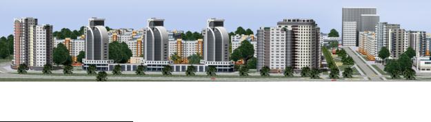
In compliance with the suggested concept of the first design option (Fig. 1), the development of the Botanika microdistrict was proposed on the section between the Orel-Bryansk railway and the Oka River floodplain.
Fig. 1. General view of the Botanika microdistrict, Orel. The first design option
2 The map of environmental zoning of Orel for environmental research.
99