

The Evolution of Stone Tool Technology |
45 |
systematic investigations in the 1950s and 1960s.19 Three cave sites in South Ossetia (Kudaro I and III andTsona) and one in Azerbaijan (Azykh), each with undisturbed Acheulean layers, provide the best picture (Figure 2.3).20
Stone tools were manufactured from locally available material – quartzite, lydite, alevrite, limestone, slate, and flint – found both as smooth pebbles and knobby nodules at outcrops. The assemblage of tools shows selectivity in stone types. Heavy-duty tools such as choppers, bifaces, and side-scrapers were knapped from quartzite pebbles, whereas flint was used for finely worked smaller tools (transversal side-scrapers), not more than 6 cm in length (Figure 2.3).The considerable scatter of hammerstones, cores and many cortical fl akes indicate that tools were worked in caves.
As a technically superior tool compared to the earlier pebble choppers, what was the function of the Acheulean hand axe and did it engender any behavioural changes? Usually these handheld tools have been associated with chopping and butchering large animals, yet the large size of some examples would make them a clumsy implement. Furthermore, some do not display any signs of use, suggesting that they may have had other purposes. In a novel idea, it has been proposed that the hand axe served as a badge for an eligible male, much like conspicuous plumages in birds are important in sexual selection.21 A symmetrical hand axe – sharp and knapped with precision – might have had appeal to the aesthetic sensibilities of a female, signalling to her the requisite qualities for fatherhood, including skill, coordination, and persistence. Once a mate had been attracted, the hand axe would have served its function and been discarded. Similarly, we should ask why after 1.7 million years of use the hand axe was abandoned. Could it be that female preferences for male traits changed? Were there other qualities and preferences at the end of the Lower Palaeolithic that were superior models of sexual selection? We shall come to those questions later.
Diet
There was a significant shift in animal populations from the time of Dmanisi to the Acheulean cave sites. Sabre tooth cats, rhinoceroses, giraffes, and their contemporaries gave way to other large mammals, such as the now extinct Deninger’s bear (Ursus deningeri), which comprises 85 per cent of the large mammal remains in the Kudaro III cave. Most of the bear bones belong to adults that died naturally, pointing to the seasonality and dual occupancy of the caves: bears in winter, humans in spring and summer.Where the human
19Zamiatnin 1937. For the northern Caucasus, see Doronichev 2000, 2008; Golovanova 2000; Doronichev and Golovanova 2003.
20For synoptic overviews of these earlier excavations and accompanying bibliographies, see Liubin 1984, 1989.
21Kohn and Mithen 1999.
46 |
Trailblazers |
residents went in winter we are not quite sure. Certainly when they were at Kudaro they ate well.Their kitchen was quite varied and lavish. In addition to venison, the community consumed different types of birds, but favoured only one fish – Black Sea salmon (Salmo trutta labrax), which accounted for all the 50,000 fishbones recovered. Other fish, including the many species of Black Sea shad, clearly did not suit the local palate.
THE GREAT DIVIDE: THE CAUCASUS IN THE MIDDLE
PALAEOLITHIC (150,000–35,000BC)
The transition from the Lower to Middle Palaeolithic (ca. 400,000–200,000 BP) is a watershed interlude of global significance in palaeoanthropology.
In Europe and the Near East, this stretch of prehistory witnessed the rise of a new hominin species, Homo neanderthalensis, the Neanderthals, who survived up to about 40,000 years ago.22 Their story is a long, complex, and controversial one, clouded in the popular imagination by the powerful and persistent nineteenth-century representation of a shambolic brute.23 With physical traits such as heavy brows, thick bones and musculature, and tendencies to degenerative joint disorders, Neanderthals have been described frequently and unfairly as brutish individuals in possession of little intelligence. Scientists today, however, see them in a vastly different light. Rugged, to be sure, Neanderthals had a physiognomy that reflected the many demanding tasks they performed, but they also possessed many remarkable skills that enabled them to survive the vagaries of the harsh and oscillating climatic conditions of the later Middle and Upper Pleistocene.
Neanderthals were inventive enough to produce a new technique for the production of stone tools, the disc-core technique, also known as Levallois (Mode 3). This fundamental shift in in tool production brought an end to bifacial (Acheulean) hand axes and introduced tools made from predetermined fl akes. This technological change from core to fl ake tools signposts a major jump in the conceptual abilities of human populations.The cleverness of the Neanderthals extended to other areas.They wore clothing, built fires, gathered in settlements, hafted some of their tools and were skilful hunters of reindeer and mammoths.24 They had to be, for there was little vegetation on the cold tundra. Neanderthals showed other human qualities.They were the first to bury their dead deliberately. The sprinkling of red ochre over the corpse and simple grave provisions placed in the pit grave, also reflect tenderness. Yet Neanderthals also showed a streak of violence that could despatch their enemies swiftly and decisively.
22Higham et al. 2014.
23Trinkaus and Shipman 1993.
24On controlled fire in the Palaeolithic, see Twomey 2013.
The Great Divide: The Caucasus in the Middle Palaeolithic (150,000–35,000 BC) |
47 |
4
1 3 5
2
|
6 |
|
|
|
|
|
|
|
|
1213 |
16 |
|
|
|
|
|
|
Black sea |
7 |
9 |
17 |
|
|
|
|
|
8 |
|
|
|
|
|
|||
|
14 |
|
|
|
|
|||
|
10 |
11 |
15 |
Kura |
|
|
|
|
|
|
|
|
|
|
|
||
|
|
|
18 |
|
20 |
30 |
31 |
River |
|
|
|
|
19 |
|
29 |
||
|
|
|
|
|
|
|
|
|
|
|
|
|
|
22 |
27 |
28 |
|
|
|
|
|
|
|
|
||
|
|
|
|
|
|
26 |
|
|
|
|
21 |
|
24 |
|
|
||
|
|
|
23 |
|
|
|
||
|
|
|
|
|
|
|
|
|
|
|
|
|
|
|
25 |
|
Lake Sevan |
|
River |
|
|
|
|
|
|
33 |
|
|
|
|
|
Araxes |
32 |
||
Murat |
|
Lake |
|
|
|
|
|
|
|
|
|
|
|
|
|
||
|
|
Van |
|
|
|
|
|
|
 Lake Urmia
River
|
1 |
Maluzka |
|
2 |
Mezmaiskaya |
|
3 |
Dakhovskaya Cave |
|
4 |
Barakaevskaya |
|
5 |
Monasheskaya Cave |
|
6 |
Apianchi |
|
7 |
Guargilas Klde |
|
8 |
Ortvale Klde |
Caspian |
9 |
Gvardjilas Klde |
10 |
Mgvimevi |
|
sea |
11 |
Dzudzuana Cave |
12 |
Djruchula |
|
|
13 |
Samgle Klde |
|
14 |
Samertskhle Klde |
|
15 |
Sagvardjile V |
|
16 |
Togon Klde |
|
17 |
Taro Klde |
|
18 |
Balgodarnoye Group |
|
19 |
Paghaghbyur Group |
|
20 |
Metsavan Group |
|
21 |
Arteni Group |
|
22 |
Aparan Group |
|
23 |
Hrazdan Group |
|
24 |
Gutanasar Group |
|
25 |
Hatis Group |
|
26 |
Kalavan 1&2 |
|
27 |
Hovk 1 |
|
28 Hovk 2&3 |
|
|
29 |
Yenokavan 1 |
|
30 |
Gilik |
|
31 |
Hatsut |
|
32 |
Angeghakot |
|
33 |
Aghitu |
|
N |
|
0 |
50 km |
Glaciers |
|
||
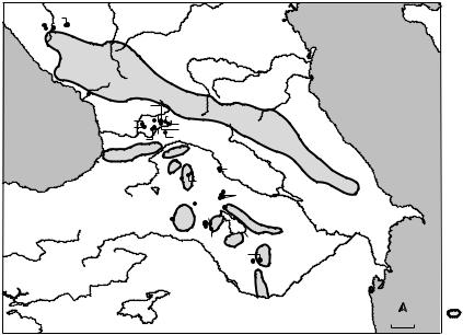
Figure 2.4. Map showing the key Middle and Upper Palaeolithic sites in the Caucasus, and the extent of the glaciers (after Liubin 1989, drawn by C. Jayasuriya).
Neanderthal communities settled in the Caucasus (Figure 2.4), as they did in many areas from the edge of Western Europe to the steppes of Central Asia. During the Middle Palaeolithic, the Caucasus and northern Europe experienced the same climatic changes.25 The European data broadly correspond with the palynological information collected from several archaeological sites, such as Matuzka Cave (the northern Caucasus) and Ortvale Cave (the southern Caucasus), which suggest that the landscape of the Caucasus fluctuated between deciduous woodlands, periglacial meadow-steppe environments, and coniferous forests, depending on the climate and altitude.
In the Caucasus, we are fortunate to have a snapshot of this critical period between the Lower and Middle Palaeolithic. Recent excavations at Nor Geghi 1, Armenia, discovered in 2008, have revealed a unique assemblage of bifacial and Levallois technology, with the latter displaying typical characteristics such as Quina retouch (Figure 2.5 (1,2)).26 Cultural debris was stratified within five units laid over approximately 150,000 years (ca. 308,000 ± 3,000 for top of Unit 1, and 441,000 ± 6,000 for the lower basalt deposit). All the stone tools at Nor Geghi 1 were struck from obsidian cores obtained mostly from the
25In palaeoclimatic terms this period runs from OIS 5e (130/126,000–118/115,000 BP) when glaciers retreated through OIS 5d–a (Early Glacial period, ca. 118/115,000–74, 000 BP), and OIS 4 (75/71,000–60/58,000 BP) when the ice age was harshest, to OIS 3 (60/ 58,000–28/25,000 BP), a period of relatively mild climates.
26Adler et al. 2014. For an overview of the Armenia Middle Palaeolithic, see Gasparyan
et al. 2014b.
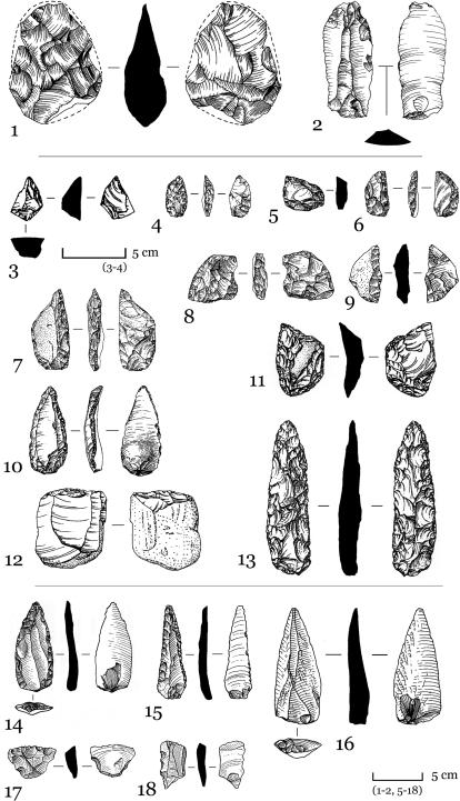
Figure 2.5. Mousterian stone tools: Transition – (1, 2) from Nor Geghi 1 (after Gasparyan et al. 2014b); the northern Caucasus – (3, 10–13) from Matuzka cave; (4, 6, 7) Mezmaiskaia cave; (8) Il’sakia; (5, 9) Micoquian sites in the northern Caucasus (after Golovanova and Doronichev 2003); the southern Caucasus – (14–16) from Bagratashen 1 (after Gasparyan et al. 2014b); (17–18) Ortavale Klde Layer 10 (after Adler and Tushabramishvili 2004).
48
The Great Divide: The Caucasus in the Middle Palaeolithic (150,000–35,000 BC) |
49 |
source at Gutanasar (97 per cent of the total), located 2–8 km to the north-east. Other sources were further afield, such as Hatis, Pok Arteni, and Pok Sevkar. Toolmaking and re-sharpening, however, was a home-based activity, not one carried out at the sources.
How, then, should one interpret this combination of technologies? It could be argued that Nor Geghi 1 was the seasonal home of different population groups practising different modes of stone tool production. This would not, however, agree with the compelling hypothesis, based on wide-ranging data from Africa and Eurasia, that Late Acheulean populations were technologically adaptable.That is to say, Levallois technology was not in itself a sharp and abrupt breakthrough, but rather emerged from the Late Acheulean tradition as a confl ation of diverse lithic traditions shared by different communities. This second hypothesis calls into question the notion that Levallois technology spread from a single point of origin and that it was spread by a clearly defined hominin group. Instead, it argues for an evolutionary process across a vast area, Armenia included, whereby human populations adapted to their new environments, sharing ideas and changing their behaviour.The eventual result of this process was the dominance and ubiquity of Levallois technology, pointing to its adoption by anatomically different hominin groups who lived in vastly different environments.27
Even a quick glance at the distribution of known Middle Palaeolithic sites in the Caucasus (Figure 2.4), numbering close to 300, will reveal a striking asymmetry. Most sites in both the northern and southern Caucasus are found in the western half of the region, with only a few poor surface scatters in Dagestan representing the eastern side.This is not an artificial pattern reflecting an absence of fieldwork in the eastern territories, but rather a clear preference for the regions around the Black Sea. It seems, then, that the boundary for Middle Palaeolithic settlement in the Caucasus is an oblique line running from the Terek River to the Kura-Alazani confluence.28
Until recently, most researchers followed Liubin in correlating the Caucasian Middle Palaeolithic stone tool industries and the subsistence strategies of their makers with the well-known French sequences.29 For that reason many assemblages from the Caucasus were attributed to the Typical Mousterian or Denticulate Mousterian with each category displaying Levallois
27Levallois technology dominated the OIS 8 to OIS 3 periods.A multitude of cores from deep-sea sediments and stratified ice sheets provide the most nuanced guide to global climatic oscillations.The isotope timeline is expressed either as Oxygen Isotope Stages (OIS) or Marine Isotope Stages (MIE). Some 104 stages extending back 2.614 million years ago have been identified. For OIS dates see Lisiecki and Raymo 2005, whereas the MIS boundaries can be found at www.lorraine-lisiecki.com. Slightly different absolute dates are given in Aitken and Stokes 1997, and Wright 2000.
28Golovanova and Doronichev 2003;Adler and Tushabramishvili 2004: 100.
29Liubin 1977, 1989.
50 |
Trailblazers |
and non-Levallois elements. It now seems clear, however, there are differences between the assemblages from the northern and the southern Caucasus, which reflect central European and Near Eastern characteristics respectively.
According to Liubov Golovanova and Vladimir Doronichev, three broad cultural divisions incorporating several geographical clusters can be discerned for the Middle Palaeolithic of the Caucasus:30
(a)The first is located in the north-western Caucasus, especially in the Kuban River basin. Key excavated sites include Matuzka Cave and Mezmaiskaya Cave, sequences have been found at Il’skaya 1, Il’skaya 2, and Baranakha 4 open-air sites, Monasheskaya Cave, Barakaevskaya Cave, and Gubs rock shelter 1. Other sites have been excavated, but most of the approximately eighty locations that have been recorded are surface scatters. Culturally, many of these north-west Caucasian sites represent a local variant of the East Micoquian industry (ca. 130,000–70,000 BP), an early Middle Palaeolithic lithic industry distinguished by asymmetrical bifaces, and are associated with the hunting of steppe bison.
(b)The southern foothills of the Caucasus comprise the second group. This is the largest concentration, and most are located in Georgia, where some 200 limestone caves and rock shelters are known.31 Geographically, there is one cluster in Abkhazia to the west and another in the central region of Imeretia and southern Ossetia, especially in the Rioni basin. Ortvale Klde, Djruchula Klde, and Tsona Klde belong to this group and are the most informative sites in the southern Caucasus, owing to the new methods employed in recent investigations. These south Caucasian assemblages resemble the Levantine and Karain (south Anatolian) Mousterian industries, but they display local attributes, too. Subsistence strategies are quite diverse, routinely featuring both carnivore and non-carnivore animal bones, though the cave bear, Ursus spelaeus, is the most prominent.
(c)The third group is made up of sites scattered along the high volcanic ridges that run from the Javakheti region of southern Georgia and northern Armenia to western Azerbaijan. Notable sites include Hovk 1, Kalavan 2, Lusakert 1 and Yerevan 1, all located in Armenia.32 Their lithics reveal a high percentage of truncated and faceted Mousterian tools, resembling those in the Zagros Mountains.These hunters preyed on ungulates that roamed the arid grass and forest environments.
Although this tripartite scheme provides some accurate observations, it is nonetheless a picture composed of broad brushstrokes and lacks nuances that
30Golovanova and Doronichev 2003.
31Tushabramishvili et al. 1999: 65.
32Gasparyan et al 2014b.