

CHAPTER SEVEN
Early Mesopotamian Urbanism in
Comparative Perspective
Evidentiary Biases
Where trade flows, its ramifications in the form of increasing social complexity and urbanism soon follow. Thus, the precocious development of southern Mesopotamia throughout the fourth millennium BC comes as no surprise. The uniqueness of the development in the south at this point becomes clear when we compare available survey and excavation data for the nature of both sites and patterns of settlement in the alluvium against comparable data from neighboring regions, and particularly from Upper Mesopotamia. Such comparisons are difficult, however, because of the very different archaeological recovery biases inherent to each of the two areas. These biases must be kept in mind when
evaluating available evidence.
The first bias stems from the different archaeological methodologies used to survey parts of the two areas under comparison (Wilkinson 2000b). Though the quality and variety of surveys in Upper Mesopotamia vary widely, a large portion of pertinent results for that area stem from a small number of fairly recent and fairly systematic surveys that emphasized full coverage of the surveyed areas, included a significant walking component, and made considerable effort to map variations in the extent of the occupation of individual sites through time (e.g., Wilkinson 1990a, 2000a; Wilkinson and Tucker 1995; Wilkinson in Al-
EARLY MESOPOTAMIAN URBANISM IN COMPARATIVE PERSPECTIVE |
101 |
gaze et al. 1992; Algaze et al. 1994; Sallaberger and Ur 2004; Stein and Wattenmaker 1990; Ur 2002a; Ur, Karsgaard, and Oates 2007). In contrast, many of the pertinent surveys available for the south (e.g., Adams 1981; Adams and Nissen 1972; Gibson 1972; H. Wright 1981b), while also systematic, were conducted well over thirty years ago and, because of political uncertainties (Robert M. Adams, personal communication, 2006), were designed from the beginning to be extensive in nature, so as to cover as large an area as practicable during the rare times when regional fieldwork was possible in Iraq during the 1960s and 1970s. As a consequence, those surveys generally did not include as substantial a walking component as their more recent Upper Mesopotamian counterparts or made as detailed an effort to map the extent of occupation of different periods in each of the sites surveyed. Thus, in the aggregate, available surveys of southern Mesopotamia are more likely than existing Upper Mesopotamian surveys to have missed small shallow sites and are more likely as well to misrepresent the extent of occupation in any one period.
A second bias is perhaps more consequential and stems from the different historical trajectories of Upper and southern Mesopotamia throughout the fourth and third millennia. As will be outlined in greater detail below, across Upper Mesopotamia there is a widespread discontinuity in settlement patterns between the Late Chalcolithic (fourth millennium) and Early Bronze Age (third millennium) periods. Accordingly, in many cases, and particularly so in smaller sites, fourth-millennium layers are not covered by later deposits and are clearly recognizable in survey. In contrast, the reverse is true in southern Mesopotamia, where substantial overall settlement continuity was the norm between the fourth and third millennia, which often results in the masking of earlier Uruk materials under later Early Dynastic deposits across a wide cross section of sites.
The third and final bias is probably the most important and is a consequence of the very different geomorphological processes operating in Upper and southern Mesopotamia. Processes typical for the southern lowlands include river meandering (particularly likely under the climatic regime of the area in the fourth millennium), alluviation, and aeolian sand deposition (Wilkinson 1990b, 2000b, 243–44), conditions that would naturally tend to destroy or obscure a large proportion of the smaller Uruk period sites in southern Mesopotamia. In contrast, the main geomorphologic factor affecting site recovery in the Upper Mesopotamian plains is erosion caused by both episodic winter rains and the year-round
102 |
CHAPTER SEVEN |
grazing of sheep. This would tend to enhance (rather than mask) site recognition.
Put together, these various biases mean that results from well-sur- veyed portions of the Upper Mesopotamian plains pertinent to the fourth millennium should be fairly representative of conditions in that area at the time while comparable results from southern Mesopotamia probably significantly understate the extent of contemporary Uruk period settlement. Keeping this important caveat in mind, we now turn to brief contrastive summaries of the relevant data from both regions.
Florescent Urbanism in Alluvial Mesopotamia
Available survey data for southern Mesopotamia are derived largely from systematic surveys of substantial portions of the Mesopotamian alluvium conducted in the decades between the 1950s and 1970s by Robert McCormick Adams and a group of his associates and students (Adams 1965, 1981; Adams and Nissen 1972; Gibson 1972; H. Wright 1981b; for a reworking of the data, see now Kouchoukos 1998, 230–49; Kouchoukos and Wilkinson 2007; Pollock 2001; and Wilkinson 2000b). While results from these surveys are not particularly fine-grained from a chronological standpoint, available evidence indicates that multiple interacting urban sites existed there throughout every phase of the Uruk period, all situated alongside water channels and within relatively short distances of each other, and each positioned at the apex of a variegated settlement structure.
This pattern was in place already by the first quarter of the fourth millennium, the Early Uruk period, when Warka is estimated to have been between 70 to 100 hectares in extent, and at least three other sites across the alluvium were 40 hectares or larger in size (Eridu, site 1237, and Tell al-Hayyad [site 1306]). Multiple other sites across the alluvium at this time were in the range of 15–25 hectares (Adams 1981; H. Wright 1981b), as detailed in figure 16 and appendix 1. These centers did not exist in isolation. When the relevant survey data are tallied, it appears that they anchored complex settlement grids minimally comprising four tiers in depth (Johnson 1980, 249). Indeed, available data indicate that the proportion of the population living in relatively large town-sized (ca. 10+ ha) or urban-sized (ca. 40+ ha) agglomerations in the alluvium in the early Uruk period was just under 50 percent according to Adams’s
EARLY MESOPOTAMIAN URBANISM IN COMPARATIVE PERSPECTIVE |
103 |
(1981, 75, table 4) original calculations. If Pollock’s (2001, 216, table 6.7) recent reassessment of the same data, which tries to take into account the fact that not all sites assigned to a discrete period are likely to have been strictly contemporaneous, is preferred, that proportion rises to an astonishing 80 percent or so.1
Development in the southern alluvial lowlands reached its peak in the second half of the fourth millennium. This is clearest by the Late Uruk period. As in the earlier phases, multiple small and large towns (ca. 5–15 ha) and small (ca. 25 ha: Nippur, site 1172, site 125) and larger (50 ha: site 1306) cities existed across the surveyed portions of the alluvium at this time (fig. 17, appendix 2). What is new at this point, however, is the extraordinary development and demographic growth of the southernmost portion of the Mesopotamian alluvium surveyed by Adams, where Uruk/Warka situated on a major branch of the fourth-millennium Euphrates attained the unprecedented size of up to 250 hectares in extent, according to a detailed surface survey of the site conducted by a German expedition just before the onset of the First Gulf War (Finkbeiner 1991; fig. 18). Although there is no consensus on precisely how to correlate settlement extent and population in ancient Mesopotamian cities, there is general agreement that Nissen’s (2001, 158) estimate of 20,000 or so people for Warka in the Late Uruk period, is probably a highly conservative approximation.2
Not surprisingly, the settlement grid that surrounded Warka at this time was exceptionally complex in terms of its density and hierarchy (four or more tiers depending on how the data are analyzed). It included numerous dependent towns, villages, and hamlets situated within a 15kilometer range of the city, totaling a minimum of 280 or so hectares of further occupation (Adams and Nissen 1972). In other words, at a minimum, by the Late Uruk period, the regional polity centered at Warka had a population of well upward of 50,000 people—and this estimate necessarily excludes associated, but inherently difficult-to-trace, transhumant and marsh-dwelling populations.
While the multiurban nature of the settlement structure that had emerged in the Mesopotamian alluvium by the Early Uruk period remained essentially unchanged in the Late Uruk phase, important changes in the distribution of populations within the area did take place in the later period. Adams’s surveys document a reduction in the number of villages and hamlets in the northernmost surveyed portion of the alluvium, the Nippur-Adab area. However, all of the towns and cities that

fiGURE 16. Early–Middle Uruk period (ca. 3900/3800–3400 BC) settlement patterns in Nippur-Adab and Warka (Uruk) survey areas of the Mesopotamian alluvium.
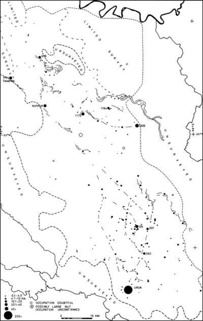
fiGURE 17. Late Uruk period (ca. 3400–3200/3100 BC) settlement patterns in Nippur-
Adab and Warka (Uruk) survey areas of the Mesopotamian alluvium.
106 |
CHAPTER SEVEN |
had existed in that area in the earlier part of the Uruk period remained inhabited into the Late Uruk phase (Adams 1981; Pollock 2001), so that the relative density of urban agglomeration in the Nippur-Adab area actually increased. Adams (1981, 70–71) plausibly suggests that many of the rural populations that abandoned the Nippur-Adab region at the end of what he calls the Early/Middle Uruk phase immigrated into the then fast-growing Uruk/Warka area. This is very likely, although it is also possible that a portion of the displaced rural populations became pastoral nomads or marsh dwellers and disappeared from the (easily traced) archaeological record.
Though smaller in scale, important changes were also taking place during the Late Uruk period in the southernmost portion of the alluvium, the Eridu-Ur basin surveyed by Henry Wright. Basing himself on the results of Anglo-Iraqi excavations at Eridu between 1948 and 1950 that show Early Uruk buildings at the top of the site filled with sand, Wright suggests that Eridu, one of the largest Early Uruk period sites in the alluvium, for the most part had been abandoned by the Late Uruk phase. This was accompanied by an expansion of Ur into a small town of approximately 10 or so hectares at this time and the foundation of a few small villages and hamlets in the northern part of the Eridu-Ur basin (H. Wright 1981b, 325–27, fig. 18). However, the extent of the growth at Ur and related rural foundations in the Late Uruk period hardly equals the population lost by Eridu in the Early Uruk phase (app. 2), so it is likely that some of the missing urban inhabitants of the Eridu-Ur basin also ended up fueling the explosive Late Uruk phase growth of Warka and its surroundings.
If anything, when considered in the aggregate, the proportion of the population of the Mesopotamian alluvium living in relatively large townsized (ca. 10+ ha) or urban-sized (ca. 40+ ha) agglomerations during the Late Uruk period was even greater than that during the Early Uruk phase. Adams (1981, 75, table 4) originally estimated that up to 70 percent of the population in the Nippur-Adab region was “urban” in the Late Uruk period as opposed to about 40 percent in the Warka area, but the latter number must be revised sharply upward to about 60 percent to account for the greatly increased estimate for the size of Warka itself at the time (250 ha as opposed to Adams’s initial estimate of 100 ha).3 These estimates are quite similar to those arrived at by Pollock’s (2001, 216, table 6.7) in her recent reassessment of the same data, which classified 70 percent of the population in the Nippur-Adab and 78 percent of the population of the Warka area as “urban.”4
EARLY MESOPOTAMIAN URBANISM IN COMPARATIVE PERSPECTIVE |
107 |
|||||||||||
|
|
|
|
|
|
|
|
|
|
|
|
|
|
|
|
|
|
|
|
|
|
|
|
|
|
|
|
|
|
|
|
|
|
|
|
|
|
|
|
|
|
|
|
|
|
|
|
|
|
|
|
|
|
|
|
|
|
|
|
|
|
|
|
|
|
|
|
|
|
|
|
|
|
|
|
|
|
|
|
|
|
|
|
|
|
|
|
|
|
|
|
|
|
|
|
|
|
|
|
|
|
|
|
|
|
|
|
|
|
|
|
|
|
|
|
|
|
|
|
|
|
|
|
|
|
|
|
|
|
|
|
|
|
|
|
|
|
|
|
|
|
|
|
|
|
|
|
|
|
|
|
|
|
|
|
|
|
|
|
|
|
|
|
|
|
|
|
|
|
|
|
|
|
|
|
|
|
|
|
|
|
|
|
|
|
|
|
|
|
|
|
|
|
|
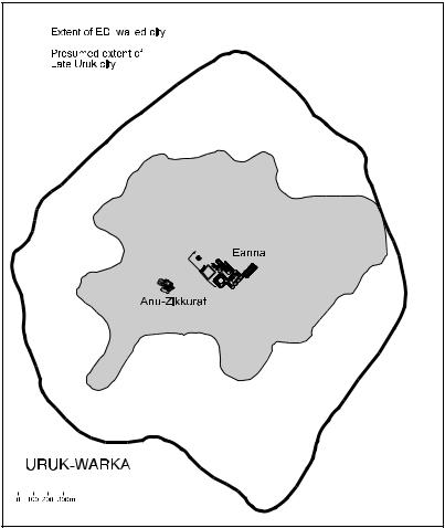
fiGURE 18. Approximate outline of the Late Uruk occupation of Uruk/Warka (interior perimeter) within the area enclosed by the ED I city wall (exterior perimeter). Also showing the location of the Eanna and Anu Precincts at the core of the city.
How do the patterns just described compare against those prevalent in neighboring areas of Greater Mesopotamia at the time? Until now it has been difficult to begin to tackle this question because of difficulties in correlating the developmental trajectories of the different areas involved as a result of chronological imprecision, the differences in the coverage of available surveys, and varying survey methodologies. However, these difficulties have now been smoothed to some extent by two
108 |
CHAPTER SEVEN |
methodological advances that, when combined, allow for comparisons of settlement processes across large areas and cultural boundaries. The first is improvements in our understanding of the absolute chronology of the fourth millennium across the various regions that composed Greater Mesopotamia in antiquity as a result of the collection of new radiocarbon dates from pertinent sites and the reanalsyis of previously collected ones (Wright and Rupley 2001). The second is the application to the Mesopotamian case of a probabilistic statistical model for the analysis of survey data elaborated by Robert Dewar (1991). First used on Mesopotamian data by Pollock (1999, 2001), Dewar’s model corrects for the fact that not all sites assigned to a discrete period are likely to have been strictly contemporaneous and allows for comparisons to be made between survey data categorized in terms of chronological periods of disparate length.
These advances have made possible a recent comparative review of the available survey data from southern and northern Mesopotamia in the fourth millennium by Nicholas Kouchoukos and Tony Wilkinson (2007; see also Kouchoukos 1998 and Wilkinson 2000b). They make three important points that are particularly relevant here. The first is that settlement processes in Greater Mesopotamia throughout the Uruk period appear to have been causally articulated over vast regions. Indeed, Kouchoukos and Wilkinson persuasively show that, when recalculated using a single standard, demographic trends in the Mesopotamian alluvium and immediately neighboring areas appear to be inversely correlated at the time: growth in the Warka region took place not only at the expense of the Nippur-Adab and Eridu-Ur areas, as argued earlier, but seemingly at the expense of neighboring peripheral regions as well, where a monotonical decline in settled population can be observed throughout the fourth millennium. As charted in figure 19, which is abstracted directly from Kouchoukos and Wilkinson’s work, this inverse regional correlation is clearest when we compare demographic trends in southern Mesopotamia and the Jazirah plains north of the Jebel Sinjar in northern Iraq. However, comparable demographic trends are also observable in other more remote areas at the periphery of alluvial Mesopotamia, such as Fars Plain in southwest Iran, where Sumner (1986, 200, 208, fig. 3) documented a steep decline (by a factor of 5) in settlement extent (and population) that correlates temporally with the demographic boom in the Mesopotamian lowlands through the Uruk period. To be sure, some of the settlers “missing” from Upper Mesopotamia and Fars