

Galichian R., Historic Maps of Armenia the Cartographic Heritage
.pdfFigs 28 and 29
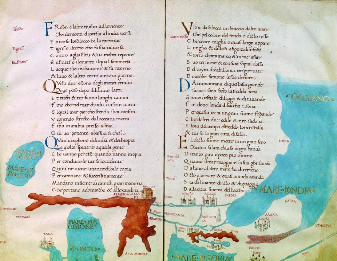
ThesetwomapsarefromthemanuscriptbookofpoemsentitledLaSphera by the Italian brothers Ghoro or Grigorio (1362–1435) and Leonardo Dathi.Thetextisapoemabouttheearth,thesun,themoonandthestars. On some of the pages of this book there are maps drawn and coloured by hand. The maps shown here are from a 1470 copy of the manuscript.
Thefirstmapisonthebackoffolio16andshowsabasicT-Oor‘Christian’ map of the earth as well as the more advanced actual map of the earth as visualized then. North in both maps is at the left and east at the top. The Red Sea is painted red, and the vertical sea in the middle is the Mediterranean with the Black and Azov Seas extending to the left from the top. The Caspian is shown connected to the Arctic Seas.
The other map is on the back of folio 17 and the front of folio 18. Here again east is at the top of the map. To the right we have the Indian Ocean andtheRedSea(inred),belowrightistheeastendoftheMediterranean. At the left is the Black Sea and centre-page on the left is the Caspian. The red mass at the bottom of the left page is the mountain ranges, above whichArmeniaproperisshown,withNoah’sArk.Totherightofthemis Armenia Minor, with the Rivers Tigris and Euphrates, which have their source in the mountains of Armenia, as similarly depicted in the Babylonian map of the sixth century BC. (See Fig. 1.) The two rivers flowing through Babylon terminate in the Mare Indica (Persian Gulf and the Indian Ocean).
The city of Karo (Cairo) is shown on the Nile and Mecca in Arabia. Other citiesshownareTauris (Tabriz),Baldach (Baghdad),Nineveh and Domascho (Damascus).
Size c. 17x27cm
British Library – London, Add. MS 22329
28
80
29
81

30a
Fig. 30/30a
ThisT-OtypemapoftheworldisfromthehistorybookentitledRudimentum Novitorium (TheNew Beginning), printed in 1475 in Lübeck, Germany. This is the first printed map of the world. Neither the author of the text nor the cartographer is known.
The map follows the general guidelines of T-O maps, but the Mediterranean is not shown. It can only be assumed that the cartographer imagined it to occupy the vertical gap between the two woodblocksfromwhichthecircularmapwasprinted.Themapshowsthethreeknowncontinents of Asia, Africa and Europe. As per the accepted norm, east is at the top of the map, where Adam and Eve are shown, wearing some sort of clothing. As this clothing is somewhat puritanical (see detailFig.30a)itisdifficulttodistinguishonefromtheother.Themapincludessomegeophysical features and the names of all known countries.
Armeniaislocatedattheteno’clockposition,nearertotheedgeofthemap,withHircania, Kaldea (Chaldea), Babilon, Assyria, Iberrea (Iberia),Caspy and Albania. UnusuallyforaT-Omap,Mount Ararat and Noah’s Ark are omitted.
Size c. 38cm dia.
British Library – London, Rare Books C.3.d.7, ff 74v/75r |
30 > |
82


31a
Fig. 31/31a
This astrolabe is the work of the Armenian physician and scientist Amirdowlat of Amasia, son of Yeghia. He was born in the city of Amasia around 1420 and died in Constantinople in 1496.
Trained in medicine and alchemy and fluent in many languages, including Arabic, Persian, 31 Greek and Latin, he was appointed court physician to Sultan Mohammed II, known as ‘the
Conqueror’(Fatih)ofConstantinople,wheremanyofAmirdowlat’smanuscriptswerewritten.
The astrolabe dates from 1479 and was made in Constantinople. It has a main circular frame with five revolving rings, engraved with symbols, the names of the stars and constellations, eccentric and concentric circles, etc. The engravings are in Armenian and it is inscribed with Amirdowlat’s name.
Fig. 31a shows Amirdowlat’s inscription, discernible inside the instrument. Brass, 118x144mm
Sold in Paris auction on 19.12.1997
84
Figs 32/32a/33/34
These three maps are from one of the earliest printed volumes of Ptolemy’s Geography, which was prepared by Nicolaus Germanus and printed in Ulm by Leonard Holm in 1482. The atlas is printed on high-quality vellum and has withstood ageing very well, displaying the original bright colours. An unusual feature of the atlas is that the maps are bound not from the middle but from one side, so that in order to be contained inside the volume the maps have to be folded twice, resulting in some discolouring in the folds. They are bound in facing pairs. The atlas has 32 maps, the traditional Ptolemaic 27 and five extra.
Fig. 32/32a
The world map is shown with the 12 winds blowing, typical of the Ptolemaic maps. The seas are blue except for the Red Sea, which is red. The mountains are light brown. Armenia Maior and Minor are shown between the Black (Pontus Euxinus) and the Caspian (Hyrcanean) Seas. The Indian Ocean is shown landlocked and the limits of the known world are left incomplete. See details of the region of Armenia in map 32a.
Fig. 33
The map of Asia Minor is ‘Tabula I Asiae’ of Ptolemy’s Geography. It shows Asia Minor with Armenia Minor at its eastern end, next to Armenia Maior, and separated from it by the River Euphrates. Many towns of Armenia Minor are shown, the most important of which is Melitena (Malatia). To its south lies the country of Cilicia.
Fig. 34
The map depicting Iberia, Colchis, Albania and Armenia Maior is ‘Tabula III Asiae’ of Ptolemy’s Geography. At the north of the map three countries are shown. The first is Colchis, located on the eastern shore of the Black Sea (Pontus Euxinus) surrounded by the Caucasus mountain range. The second is Iberia, completely surrounded by the Caucasus Mountains. These two together today form the country of Georgia. The third is Albania (today’s Republic of Azerbaijan), which is on the western shore of the Caspian Sea and is also bordered by the Caucasus mountain range.
To the south of these countries lies Armenia Maior, where various important towns, rivers, lakes and mountains are also depicted. Armenia Minor lies west of Armenia Maior, separated by the River Euphrates. Other countries bordering Armenia Maior are Mede (Media) and Assyria. It must be noted that the names shown are the Greek versions, which are sometimes difficult to decipher.
It is noteworthy that the major lakes shown are named Tospita (Van), with the town of Tospia (Tushpa – Van), shown on its shores, and Astiara, with the town of Artemita (Artamet) shown nearby. This town is in fact located near Lake Van! A third lake is also shown called Lychnitis (which is Sevan or Geghama Lake). Cities of Armenia Maior that can easily be recognized are
Artaxata (Artashat), Armauira (Armavir), Tigranocerta, Baugauana (Bagrewan), Arsamosata
(Arshamshat), Naxuana (Nakhijevan), Chorsa (Kars), Tospitis (Van) and Terva (Yerevan). (See Figs 38–42.)
Sizes 54x42cm
British Library – London, Rare Books G8175
85


32a
|
for map numbers 33 and 34 |
< 32 |
see the next spread |
87

