

Galichian R., Historic Maps of Armenia the Cartographic Heritage
.pdfFig. 97
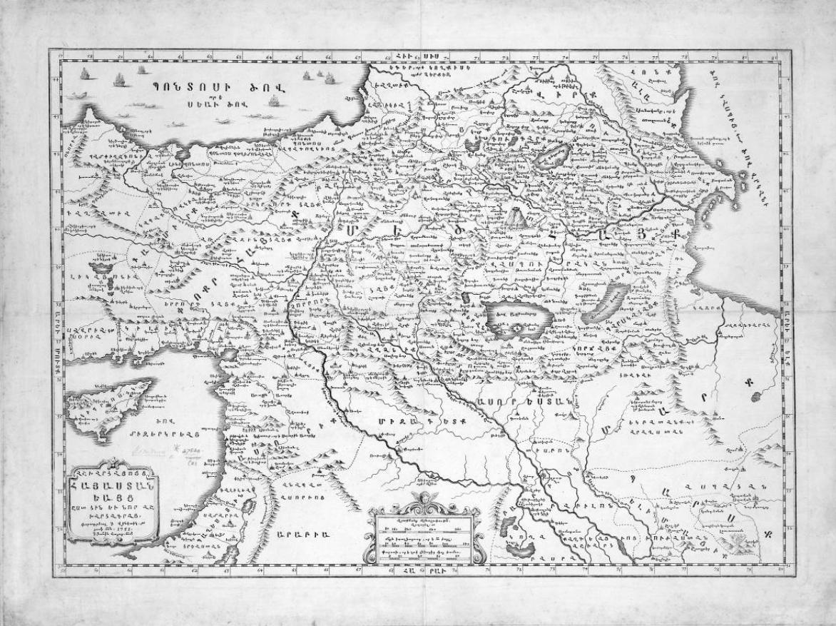
The ‘Map of the Old and New Armenia’, in Armenian, engraved by Ignatius Khachaturian and published in Venice, 1751, in the Armenian year of 1200. (The Armenian calendar is an ecclesiastical method of reckoning, starting in the year 551.)
This map shows historic Armenian territories according to old and new geographers, complete with the names of its various provinces. The map is based on the text of the Armenian geographer andhistorianAnaniaShirakatsicalledAshkharhatzuytz (Ašxarhac´uyc´ –WorldMirror).Seealso Fig. 92.
The territory is dominated by the three main geographical features, Lake Van, here called the Sea of Aghtamar, Mount Ararat, here called by the Armenian name Masis, and Lake Sevan, named Sea of Gegham, another Armenian name for this lake.
Size 45x28cm |
|
British Library – London, Maps 47830.(2) |
97 > |
180
181
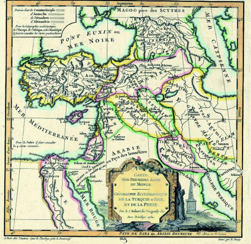
Fig. 98
The French cartographer Robert de Vaugondy (1688–1768) published his Nouvel Atlas Portatif in 1762. This map is from this atlas.
The map shows the Middle East and the Caucasus and is entitled ‘Map of the Early Ages of the World’. It shows Armenia extending from Caucasian Albania in the north-east to Cilicia in the south-west. In the south it borders Assyria and Mesopotamia. The Terrestrial Paradise – the Garden of Eden – is shown in the centre of Armenia, to the north-west of Lake Van. Aderbijan
(Azerbaijan) is located to the south of the River Arax, within Persia. The lakes of Van and Urmia are shown unrealistically close, or jointed together. This feature is quite common in the French cartography of the time.
Size25x24cm
Private collection – London, Ref. RG13
182
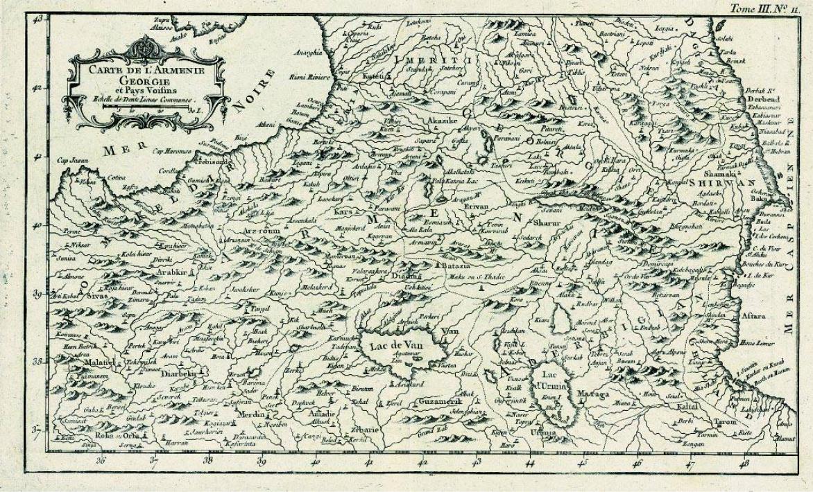
Fig. 99
JacquesN.Bellin(1703–72)publishedthefivevolumesofhisPetit Atlas Maritime in1764.Thismap, |
relatively accurately. The countries shown on the western shores of the Caspian are Dagistan and |
entitled ‘The map of Armenia, Georgia and the neighbouring countries’, is from Volume 3. |
Shirvan. The names of many rivers, mountains and towns also appear. |
HereArmeniaextendsalmostthewholewidthofthemap,withGeorgiatothenorthandAderbigian |
Size 35x24cm |
(Azerbaijan) to the south of the River Arax. In this version the lakes of Van and Urmia are shown |
Private collection – London, Ref. RG34 |
183
100
184
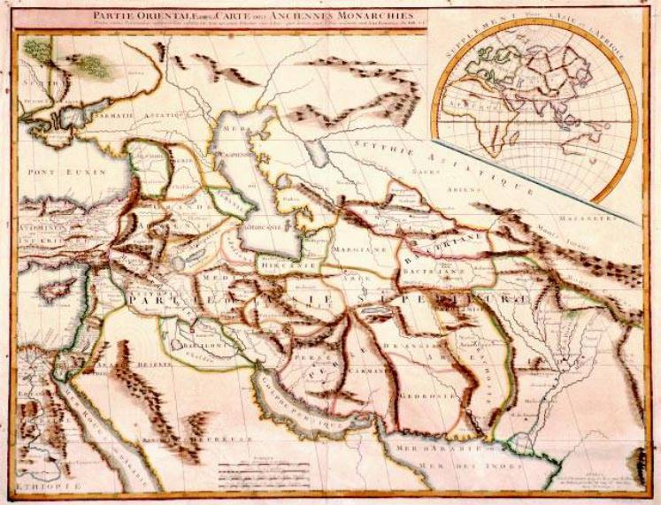
Fig.100
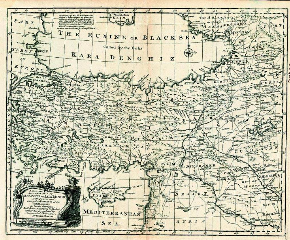
The ‘A new and accurate map of Anatolia or Asia Minor …’ is extracted from Emmanuel Bowen’s (fl.1714–67)Universal History of the World,publishedinLondon,1766.Thisverymapwasusedmany times by Bowen in his various atlases and collections of maps in 1744, 1752 and 1770.
The map shows the main cities and the roads of the area, ranging from the Persian border to westernAnatolia.SomeoftheimportantArmeniantownswhicharelocatedonthemaincommercial routesandpathsareshown.
Size42x34cm
Private collection – London, Ref. RG45
101
for 101a see the next page
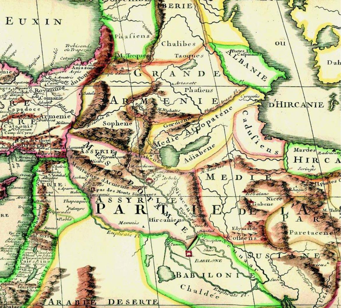
Fig.101/101a
This map is entitled ‘Partie Orientale de la Carte des Anciennes Monarchies’ (The Oriental Part of the Ancient Kingdoms) and was published in Paris in 1779 by M. Robert.
The map shows various ancient kingdoms including those of Greater Armenia, Albania, Media, Persia, Parthia, Colchis and Iberia, as well as Median Atropatena (Adiabene), which is shown as located to the south of the River Arax. In the world map inset at the top of the page, the mapping of Australia is incomplete.
The area of Armenia, divided into two parts, is shown in the detail Fig. 101a. Size 66x51cm
Private collection – London, Ref. RG24
185
102
Fig. 102
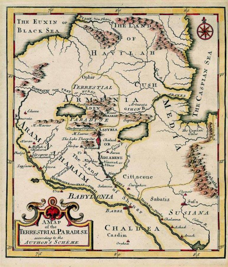
This so-called ‘curiosity’ map is entitled ‘A Map of the Terrestrial Paradise’, i.e. the Garden of Eden, which was a common perception of the area from the Middle Ages (see Section 6 of ‘A brief history’, above).
There are many versions of this map, including those of Moxon, Kircheri (Fig. 75), Stackhouse, Vaugondy (Fig. 98), Buache (Fig. 103) and others. This version was prepared by Emmanuel Bowen (fl. 1714–67) and shows EdenlocatedbetweenthelakesofVanandUrmia,within the territory of historic Armenia, with Mount Ararat situated in the middle. The Rivers Euphrates, Arax and Tigris have their sources in this area. The map was published c. 1780.
The same map also appears in Bowen’s various atlases, dating from 1744 to the 1780s.
Size23x23cm
Private collection – London, Ref. RG31
187

Fig.103
This map, which was prepared by Philippe Buache (1700–73) and was printed in Paris in 1783, is entitled ‘A General Map for Information about the History of the Saints’. It refers to the biblical lands, and in the accompanying text names Noah’s descendants whose tribes inhabited these lands.
The Terrestrial Paradise, Eden, is depicted within Armenia, which also has Mount Ararat with Noah’s Ark resting on its summit. Lakes Van and Urmia are shown joined.
(See Fig. 90, also Figs 75, 98 and 102.)
Size 26x33.7 cm. Sarkiss Boghossian collection – Paris
188
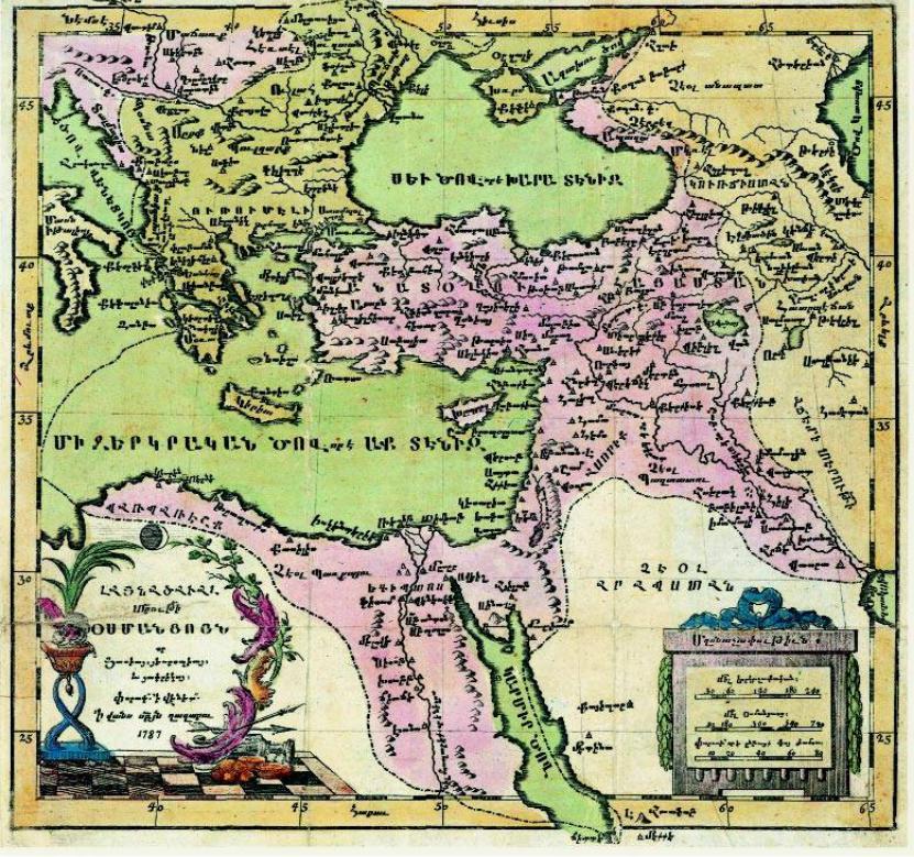
Fig.104
This Armenian-language map of the ‘Ottoman Empire’ was printed in the Armenian Monastery of San Lazzaro in Venice, in 1787.
ThemapshowstheterritoriesconqueredbytheOttomanEmpireatthetimeandistheoldestmap in Armeniandepictingthis area.Themap showsArmeniadividedbetweenthetwo neighbouring countries, the Ottoman Empire and Persia (here – Ajami). The three lakes of Van, Sevan and Urmia are shown correctly, as are the important towns of Armenia and Anatolia.
Some of the places are shown with their Ottoman as well as Armenian names. The printing house in San Lazzaro, which belongs to the Armenian Mkhitariste Order, was at the time a flourishing institution and many maps and books in the Armenian language were printed there during the eighteenth and nineteenth centuries. It still continues to be an important printing house for Armenian literature.
Size 27x26cm. British Library – London, Maps 43305.(17)
189