

Galichian R., Historic Maps of Armenia the Cartographic Heritage
.pdf24a
Fig. 24/24a
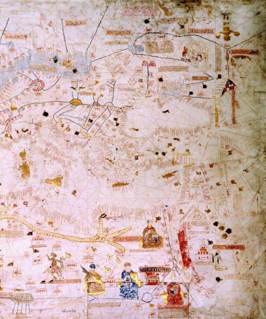
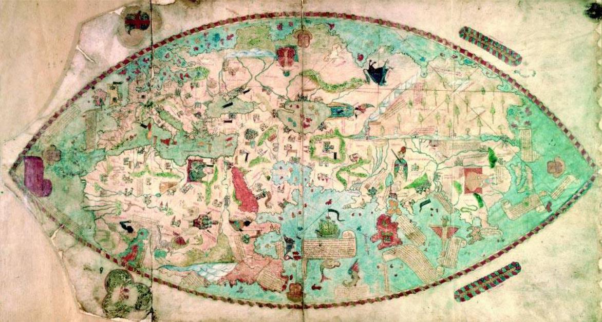
Mecia de Viladestes was a Catalan cartographer of the fifteenth century, whose portolan of 1413, known as the ‘Viladestes portolan’, is depicted here (only the eastern half is shown). The chart is drawn on vellum and has vividly coloured illuminations, and the legends are in Catalan.
This is a large and typically Catalan portolan, since in addition to the coastal towns and features, it also shows many inland details, such as cities, oases, mountain ranges and rivers. A few kings are also shown, including two nomad chiefs mounted on camels. Africa is shown with many details. It shares many similarities with the Catalan Atlas, prepared in 1375 by Cresques for King Charles V of France and kept in the Bibliothèque Nationale, Paris (Ref. MS Espagnol 30).
The Armenian Highlands are shown at the extreme right of this chart, below the Black Sea, from where the two great rivers Tigris and Euphrates are fed. Mount Ararat is also shown, with Noah’s Ark in the shape of a tent sitting atop its twin peaks (shown sideways). This is the most common form in which Armenia is shown in Catalan charts of the era. (See detail 25a.)
Size 115x85cm
Bibliothèque Nationale de France – Paris, ref. GeAA 566
70
24
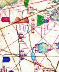
Fig. 25/25a
The circular Catalan portolan chart of Library of Estense is an anonymous chart dated c. 1450. Thechartisverycolourfulanddepictsavarietyofprinces,castellatedtowns,ships,mermaidsand animals. The decorations and paintings are executed in miniature, adorned with bright hues. Althoughmadearound1450,ithasstrikingsimilaritieswiththemorethan100-year-olderDulcert chart (see Fig. 24), as well as with the Catalan atlas of Cresques (1375). The nomenclatures and legends are in Catalan and corrupt Latin.
The Mediterranean Sea is shown with great accuracy. However, the shape of Africa is distorted, particularly in what seems to be the Gulf of Guinea, which is shown connected by a river or strait to the Indian Ocean. The large uninhabited area shown in the south may conceivably be the Antarcticcontinent,situatedatthesouthoftheCapeofGoodHope.Themapincludesthedetails assuppliedbytheobservationsofMarcoPoloandDias,andforsomeunknownreasonthevignette of Paradise is moved from Mesopotamia to East Africa.
There are many colourfully painted islands in the area that can be called South-east Asia and the Pacific, which indicates that there was already some knowledge about the abundant number of islands in this region. The whole of the world is then surrounded by waters.
BetweentheBlackandtheCaspianSeasonecanseeErmenia maior underthetwinredmountains. These mountains represent the Armenian Plateau, from where the Rivers Tigris and Euphrates originate. To the right of these stands Mount Ararat coloured dark green, with arca noe (Noah’s Ark) perched on its top. The towns of Arzenga (Erzinjan) and Malatia are on the route of the Euphrates. As mentioned previously, this is the common way of depicting Armenia in many portolans. (See detail 24a.)
The ports of the Cilician kingdom of Armenia, located in the north-eastern corner of the Mediterranean,areframedwithdarkgreen.ThedistinctionwastherebymadebetweentheChristian Armenian harbours and the neighbouring Islamic ones. It should be noted that at the time of the making of this chart this kingdom had already ceased to exist as an independent state, having been overrun in 1375.
Size 113cm dia.
Biblioteca Estense – Modena, CGA 1
25a
25 >
72
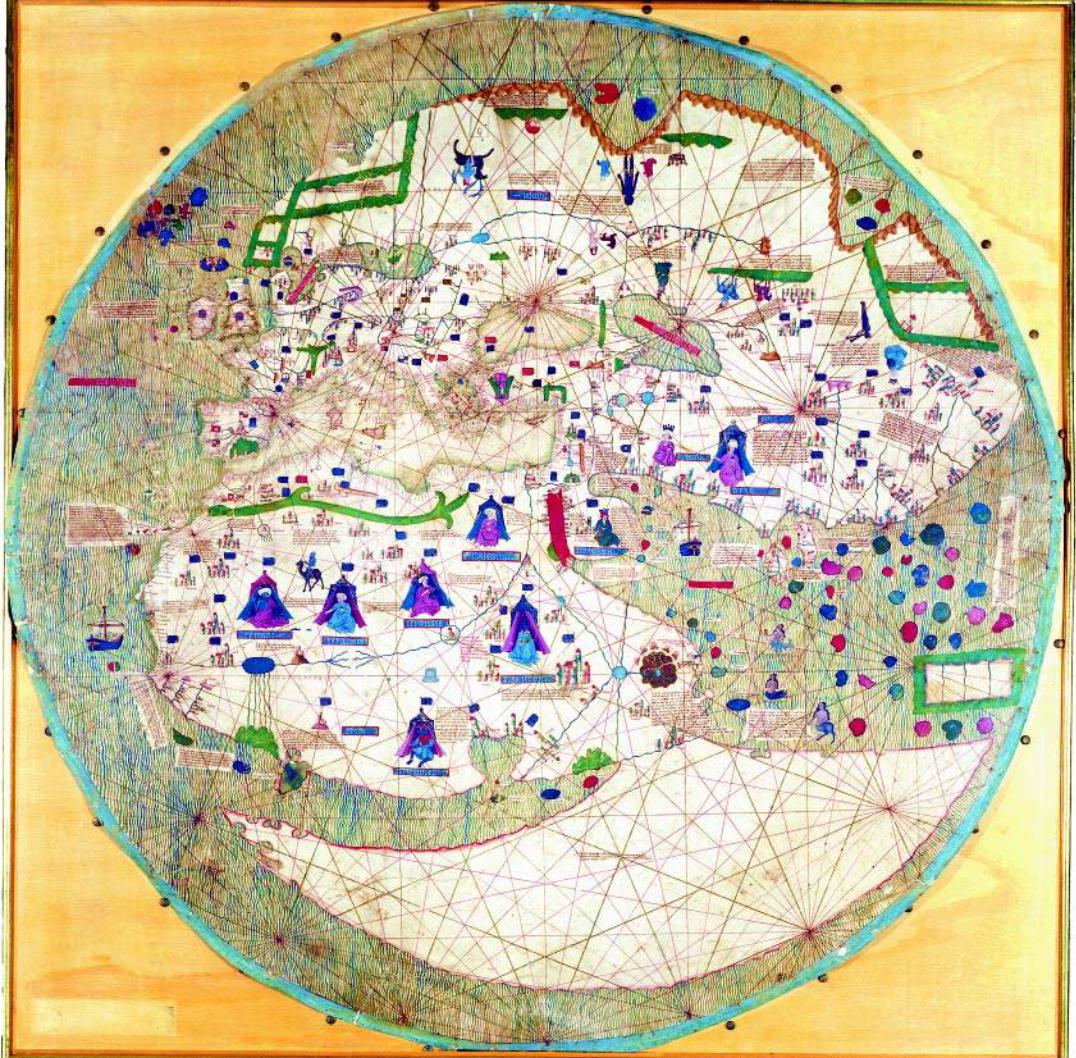
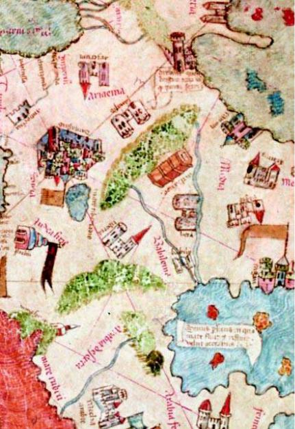
Fig. 26/26a
This Genoese map, dated 1457, occupies an important place among portolan maps. Although it is drawn on a whole parchment, its shape is nevertheless flattened oval with pointed ends, or lenticular.Themapdepicts theworldanddrawsfromPtolemaicmapsaswellastheportolanand religious tradition. The provenance of the map is not known, but as it bears the Genoan cross on the periphery, it is referred to as ‘Mappa Mundi Ovale Genoese’ (Genoan Oval Map of the World).
The layout of the map is Ptolemaic, showing the three continents, with a relatively accurate depictionoftheMediterraneanandBlackSeas.Thelegends,drawingsanddecorationsaredrawn from other world maps, such as the Hereford and Ebsdorf maps, but are secular in nature. The Caspian Sea is filled with colourfully painted imaginary islands. From the islands shown and descriptions included in the map it can be concluded that the information provided by travellers such as Marco Polo and de Conti has also been utilized. In general the map is drawn in the shape of a portolan including the rhumb lines, but in fact it can be considered as a secular encyclopedia.
A striking feature of the map is that it shows Africa surrounded by seas and thus it confirms the possibility of sailing from Europe to the Indian Ocean by sailing southwards around Africa. It goes even further and shows a European ship in the Indian Ocean. There are many texts on the map,whichareinformativebutnotveryclear.Oneofthemstatesthatthewaterssurroundingthe landmass are one continuous ocean, stretching out infinitely in every direction, covering the rest of the world not shown on the map. This implies that by sailing westwards from Europe it is possible to reach India.
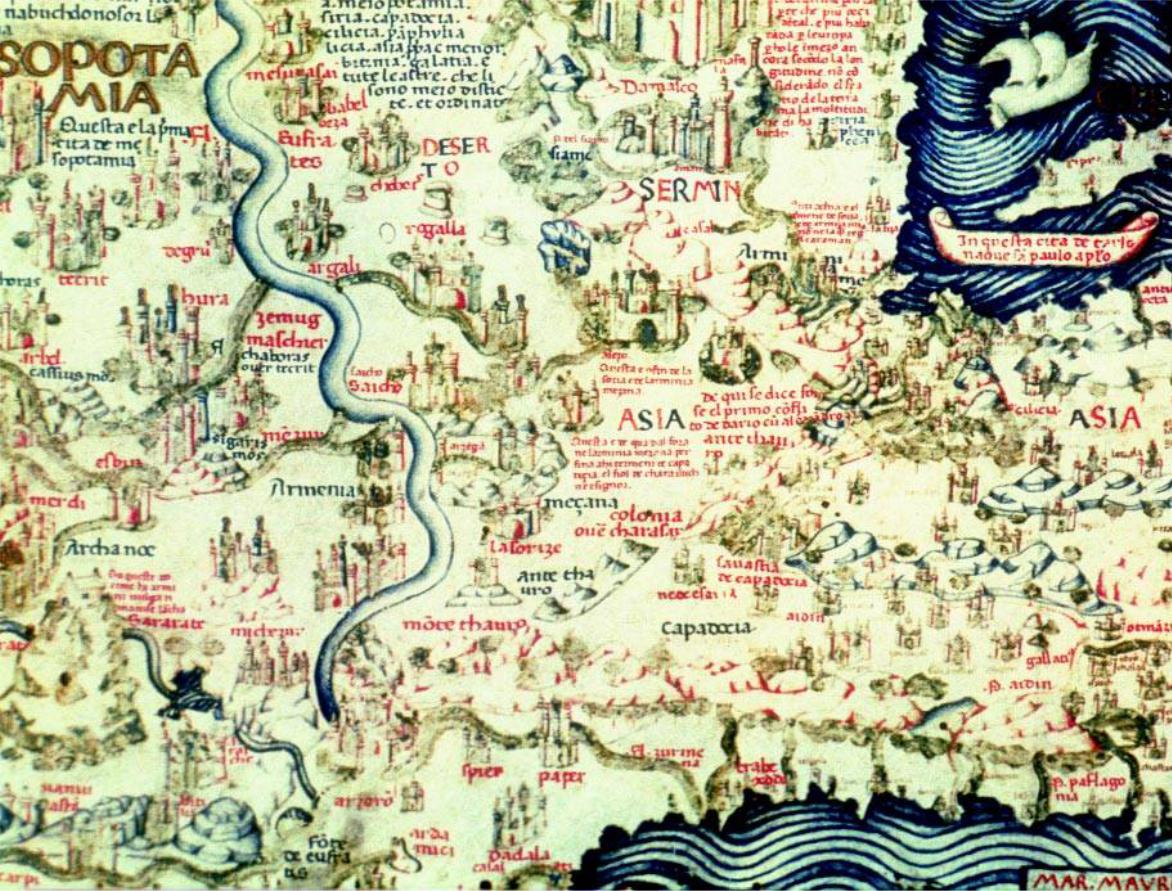
Armenia is shown between the Black and the Caspian Seas, below the inverted castle and to the
south of the Caucasus range. To its south-east, on top of green-coloured Mount Ararat, Noah’s 26a Ark is shown in the shape of a house, once again almost inverted. This is consistent with the
depiction of Armenia in the portolan tradition. (See detail in Fig. 26a.)
Reproduced by the kind permission of the Ministero per i Beni e le Attività Culturali, Italy. Copyrightprotected.
Approximately 1m wide
Biblioteca Nazionale Centrale – Florence, Port. 1
74
26
75
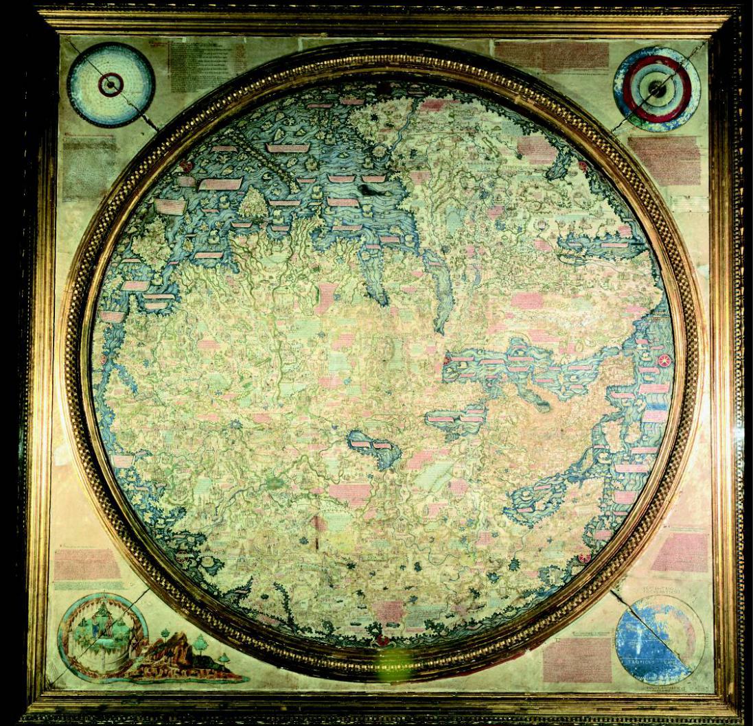
Fig. 27/27a/27b
This late medieval map is by the Venetian monk Fra Mauro (d. 1460) who lived on the island of Murano.HewasquitewellknownasacartographerandwascommissionedbyKingAlfonsoVof Portugal to prepare a world map, using the information available from the Portuguese portolan chartsofthetime.Thismapwascompletedin1459andsenttothekingwithaletter.Althoughthe letterhassurvived,themaphasnot.Fortunately,afterhismaster’sdeath,FraMauro’sassistantwas able to prepare a copy in 1460, drawing on the sketches and details that existed. This is the map that is now in Venice.
Although made only half a century after the Hereford ‘Mappa Mundi’, Fra Mauro’s map is in a different category altogether. This map can be considered as a true geographical map, containing much real and interesting information. The human figures and fantastic creatures of the ‘Mappa Mundi’ have been replaced by rivers, towns, mountains and travellers’ tales and texts relevant to the areas. For the first time roads are shown integral to the map. The map of the Mediterranean is surprisingly accurate, and, unlike the Ptolemaic maps, the route around Africa is shown as navigable and the Indian Ocean therefore not landlocked.
Themaphassouthatthetop,whichisadeviationfrommostothermedievalmaps.Thisisthefirst map to show the Caspian Sea closer to its correct shape, something that took other cartographers over 200 years to realize. Fra Mauro’s map does not have any religious base and orientation.
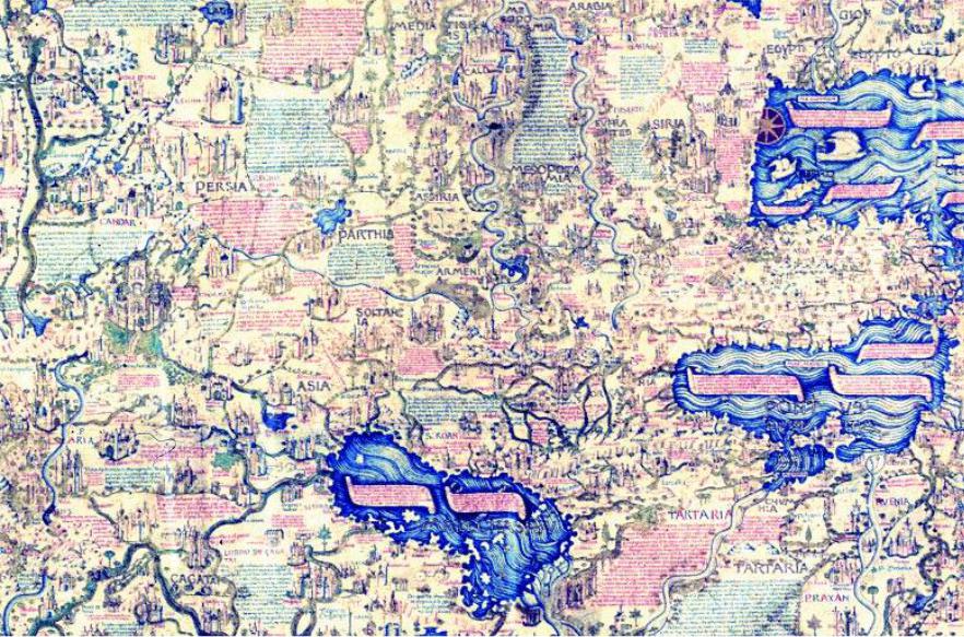
Armenia can be seen in the centre of the detail map Fig. 27a, north of (in this map – below) Parthia and Assiria and within the bend of the River Tigris. This is the general area of Armenia, which is located in the south of the area between the Black and Caspian Seas. To the left of the inscriptionthereisanothersmalleronewhichreadsArmenia Major.AnothertwoareasofArmenia can be seen on the further enlargement of the area to the right of the main legend (Fig. 27b). On the lower left of this enlargement, the pile of stones with the house on top is in fact mount Ararat (ararate), with Noah’s Ark (Archa noe) perched on it. Above, to the right of it and on the bend of the River Euphrates there is another Armenia, which is West Armenia. Furthermore, in the top right-hand side of the map, next to the visible eastern end of the Mediterranean, there is another Armenia, which is the Cilician kingdom of Armenia, located at the north-east corner of the MediterraneanSea.Somefamiliarnamesoftownssuchas arzoro (Erzerum), Satala and ardamici (possibly Artamet) are recognizable.
Size app. 2m dia.
Biblioteca Marciana, Venice |
27 > |
76
27a
27b >
78
79