

Galichian R., Historic Maps of Armenia the Cartographic Heritage
.pdfFig.13
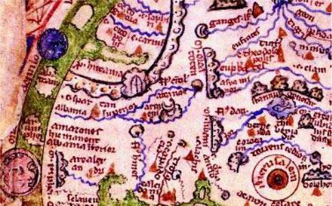
Thismedievalmapisknownasthe‘CottonianMap’,afteritsoriginalowner.Themap is a small one, made in England in the tenth or eleventh centuries and belonged to Sir Robert Cotton, whose collection was one of the three collections to form the foundation of the British Museum in 1753.
Although it was produced at the time of the rule of strict Christian topology and is vaguely in the form of a T-O map, it does not have a full circular form and the coasts of Europe are shown more accurately than on any other contemporary map. The cartographic information in the map has apparently been taken from the Roman and even Greek, pre-Christian geographers. The map is orientated with east at the top.
In the map mountains are shown in green. Red is used for the Persian and Red Seas, aswellastheNileandotherrivers.MountAraratisshownsidewayswithNoah’sArk perchedonitstop,whileArmenian Mountain appearsabovetheArk.BelowtheArkthe name Armeniacanbeseenthoughsomewhatmaskedbyprint-through.Theaccuracy of the shape of the British Isles in this map is also unusual for the period.
Contrary to the majority of its contemporaries, the map does not have a religious orientation and instead shows cities, countries, rivers and mountains, thus being a trulygeographicalmap.ThegenerallayoutisPtolemaic,whichismorethanChristian topographywouldnormallyallow.
Size 17x21cm
British Library – London, Cotton MS Tiberius BV, f 56v
50
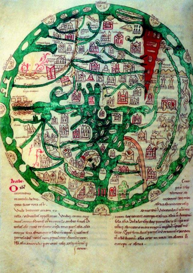
Fig.14
Isidore’s ‘Map of the World’ belongs to the T-O category of maps. There are many copies of T-O maps in the various works of Isidore, Bishop of Seville (c. 560–636), which are mostly diagrammatic and simple. (See Fig. 9.) However, others such as this reproduction, which is from an eleventh-century manuscript copy, can be more elaborate.
This map is in the basic shape of the T-O maps, with east at the top. The stem of the T,whichisthe MediterraneanSea with many islands, occupies alarge portionofthe map. The Red Sea is in the shape of a sharp inverted cone and is painted red. Mount Ararat with Noah’s Ark on its top, is situated near the upper left-hand corner of the Mediterranean, next to Armenia. The accent of the map is on Europe, where many cities and countries are shown.
Size 26cm dia.
Bayerische Staatsbibliothek – Munich, Clm 10058. f 154v
51
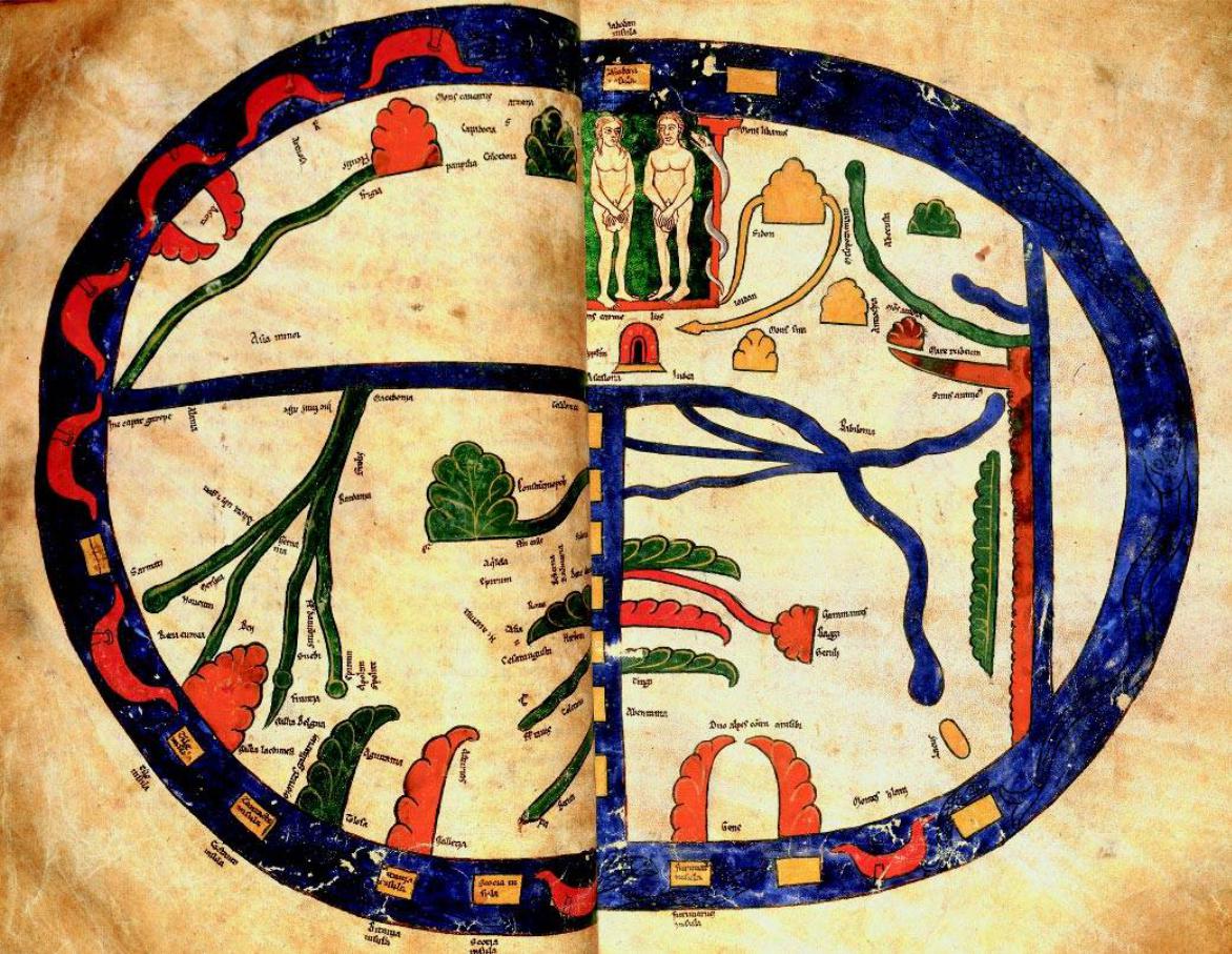
Fig. 15
The so-called ‘Beatus World Map’ is a T-O map of the world from a twelfth-century manuscript, produced by the Spanish Benedictine monk, Beatus of Liebana in his bookApocalipsin, originally written in the eighth century in Spain. This is a beautifully decorated and coloured map, inserted in the manuscript.
The vertical blue line in the centre of the map is the Mediterranean Sea. The horizontal line at the top of it is the River Don on the left and the River Nile on the right. East is at the top of the map, with the vignette of Paradise shown inhabited by Adam and Eve, accompanied by the serpent. To the left of Eve, between the green cones of the forests and the orange mountains, the words Mons Caucasus (Caucasian Mountains) appear and below it we can see Armenia and underneath it
Cappadocia.
The seas surrounding the world are brimming with serpents, fish and boats. The islands at the lower part of the map consist of Scotland, the British Isles and Iceland (Tile or Thule). It is also interesting to note the large and uninhabited island at the right of the map. Could this be Antarctica?
Reproduced by courtesy of the Director and Librarian of John Rylands University Library, Manchester, UK.
Size454x326mm
John Rylands Library – Manchester, Latin MS8, ff 43b/44a |
15 > |
52
53
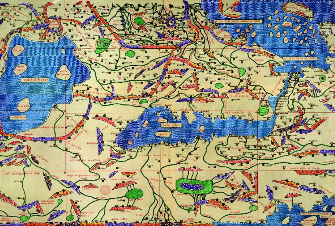
Fig. 16
Abu Abdullah Mohammad Ibn al-Sharif al-Idrisi or Edrisi (1099–1166) was one of the most importantArabcartographersofthetwelfthcentury.HewasborninCeuta,Morocco,andstudied in Cordoba. He travelled around Europe as well as going to Central Asia and the Middle East. He lived in Cordoba, where he had access to a large collection of maps and portolans. His fame led him to become the geographer of King Roger II of Sicily, who encouraged science and knowledge. Utilizing the sketches of the Greek sailors and contemporary lore, in 1154 he wrote The Book of Roger, accompanied by maps of the world, which consisted of 70 small maps in Arabic, depicting variouspartsoftheworld.
Idrisi’s manuscript contained a small-scale map of the world, based loosely on the Ptolemaic model. This map, which is now in the Bodleian Library in Oxford, is known as the ‘Small Map of Idrisi’.
Shown here is the ‘Large Map of Idrisi’ as it is known today, as reconstructed by Konrad Miller in 1927 and published in Stuttgart in 1928, based on Idrisi’s 70 small maps in The Book of Roger. The mapshowstheknownworldfromSpaintoChinaandiscolourfullyillustrated.Ithasnorthatthe bottom and in the segment shown here, which is about one-sixth of the whole map, the Black Sea is on the right and the Caspian Sea – khazar – can be seen on the left of the map. In this reconstruction the names are in Arabic, written in the Latin script.
Armeniaisdividedintothreeparts,ArmeniaMaior,calledaali armînîa,whichissituatednearLake Van,ArmeniaMinor,whichiscalledasafelarmînîa andistothenorth-westofLakeVan,whichhere is called argis. In the middle of the two lakes there is yet another Armenia, bakiet armînîa,meaning ‘therestofArmenia’. Otherrecognizabletownnamesarebidlis, kalikala (Karin,today’sErzerum), halât (Akhlât), hûi (Khoy), salmâs and nâsua (Nakhijevan).
Even in this map of 1154, bilâd alârn (Albania) is shown located north of the River Arax and bilâd âderbaigân (Azerbaijan) south of the river. All three countries of Arran, Azerbaijan and Armenia are closely linked.
Size 195x92cm
British Library – London, Maps 856.(11)
54
16
55
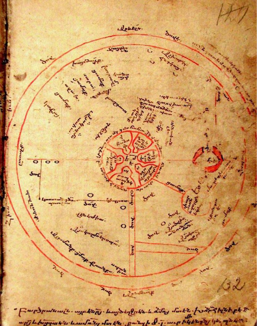
Fig.17
This anonymous T-O map is from an Armenian manuscript, which based on the analysis of its inscriptions is dated no later than 1206 CE. It is included in a collection of essays dating from the fifteenth century. The map is very slightly elliptical, with east at the top. The distorted circular shape may be due to the restrictions imposed by the size of the page on which it was drawn. The mapisanimprovementonthesimpleT-Omaps,andinitsouterpartshowsthenamesofanumber of countries, while the inner part bears the names of some important cities.
The centre of the map is occupied by the city of Jerusalem, drawn out of proportion, showing its gates and quarters. MountSinai can be seen to its south-east, with the Red Sea to its south.
TheleftofthestemoftheTbearstheinscriptionThis side is Eropa,thenthecartographercarrieson with the names of the countries of Bulgars, Alemans, Franks and Spania. More centrally the city of Venejia (Venice) is shown. The left branch of the T, starting from the island of Cyprus, is the Aegean Sea, extending to the Bosphorus, near which we see Constantinople, and then turning sharp right towards Asia. Here the Black and Azov Seas are represented as lines, which are the extensions of the River Don (not the River Dnepr, as proposed by M. Khachaturian).
On the right of the stem of the T we see the words This side is Africa. The area contains a red circle withtheinscriptionPharaoh’s army in Egypt.
The lion’s share of the map is occupied by Asia. Here, from the centre left of the map (north) we can see the country of Russ (Russia) located at the borders of Europe and then the countries of Kafa, Azach, Sara‘ and Khâwrazm (Oxiana). At the eastern edge of the map, the countries of Khaytai (China),Jaboun (Japan)and Countries of India areshown.Nearertothecentreofthemap we see the cities ofMerdin, Baghdad and Damashq (Damascus). It is curious to note that while the majority of similar maps produced in the Christian West show Armenia, Mount Ararat and Noah’s Ark, the Armenian author has chosen not to mention Armenia on his circular map.
Thewholeworldissurroundedbyanall-embracingsea,theocean,describedasThe all encompassing sea, which is in this shape.
Size 125mm dia.
Matenadaran – Yerevan, Armenia, MS No.1242
56
17
18a
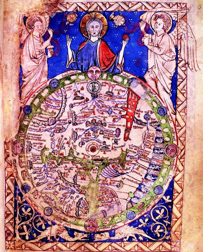
Fig. 18/18a
This Psalter map of 1250 is from a manuscript Book of Psalms. The map of the world is in the form of the Christian T-O maps, but has evolved from its simple form and like the Hereford ‘Mappa Mundi’ has become a source of religious information and knowledge. Although at the time that this map was produced there was sufficient cartographical information to enable the mapmakers to draw a relatively correct map of Europe, the maker of this map chose to adhere to Christian religious topography. Thus religious tradition overruled existing scientific knowledge.
The map is dominated by the figure of Christ, holding the T-O globe in his hand, flanked by incense-burning angels. The world is surrounded by an ocean and 12 winds. Fantastic creatures, which supposedly lived in distant lands, are also depicted in the lower right-hand section of the map,whereAfricais.Eastisatthetopofthemap.Paradiseisalsothere,shownwithriversflowing into it and inhabited by Adam and Eve. In accordance with biblical tradition, the lands of Gog andMagogareshownisolatedwithprotectivewalls,andtheRedSeaincludesacrossing,denoting theroutethatMosestook.
Jerusalem is at the centre of the map and of the world. Mount Ararat and Noah’s Ark in the shape of a crescent are at the ten o’clock position. Next to the Ark one can see the country of Arm-eni-a in red. The map contains the names of many countries and cities as well as an abundance of other information.
The detail map Fig. 18a shows the area of Armenia. Size 10x15cm
British Library – London, Add. MS 28681
58
18