

Galichian R., Historic Maps of Armenia the Cartographic Heritage
.pdfFig.117/117a
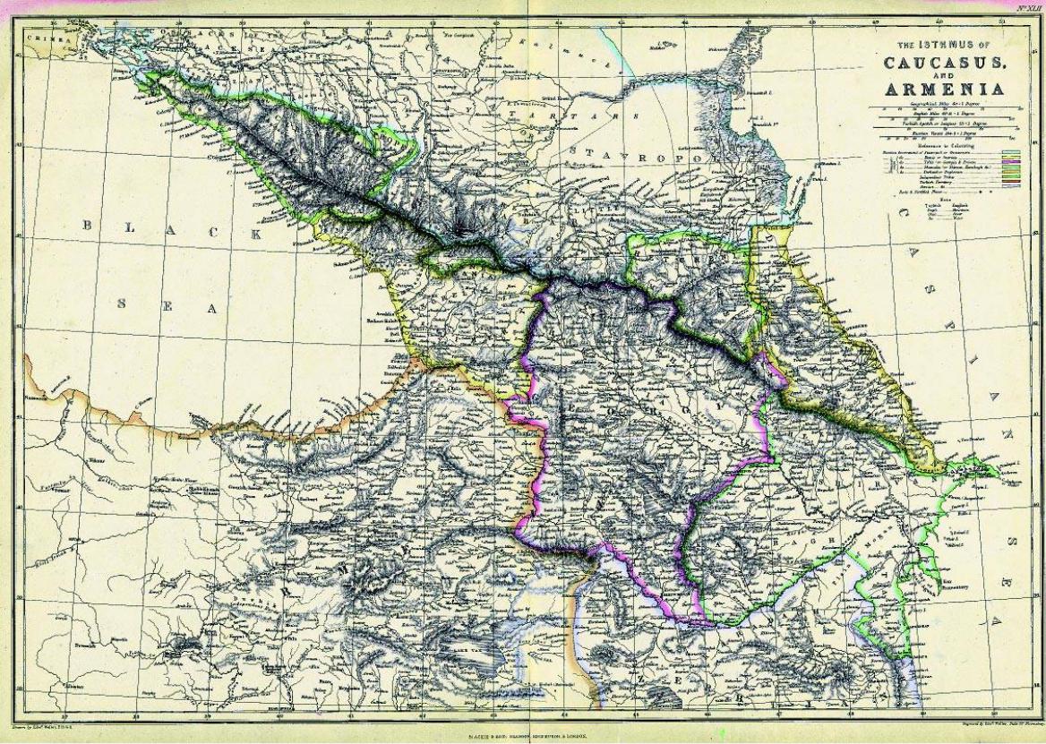
Edward Weller’s (d. 1884) map of the ‘Isthmus of Caucasus and Armenia’ is from hisDispatchAtlas of 1858.
The map shows Armenia divided mainly between the Russian and Ottoman Empires as it was during most of the nineteenth century, after the Persians had been driven out of the Southern CaucasusandEasternArmeniabecameanokrug(province)oftheTsar.Thismapiscartographically much more advanced and accurate than all previous ones.
In this map the border between Turkey and Russia crosses over the peaks of Mount Ararat, and thereisnocommonborderbetweenTurkeyandtheareaofNakhijevan,whichisshownaspartof Armenia. It also depicts the territories of Karabagh, within Russia, and Karadagh, within Persia.
Inside, as well as near the territory of Iranian Province of Azerbaijan there are a number of Armenian places that bear the Azeri prefix of “Kara”, which in the modern Azeri language means “black”. These include Karabagh (black garden), Karadagh (black mountain), Karakelisseh (black church) and Karasou (black water). The names do not seem logical, since Karabagh is a lush and green region, the mountainous area of Karadagh is not black and certainly Karakelisseh (Monastery of St. Thadeus) is not black but an all-white cathedral, with a black strip of finishing stone on the rotunda of one of its churches.
117a
According to the paper entitled “Tati and Harzani, two ancient dialects of the Azeri language” by the Iranian linguist Abdolali Karang (Tabriz – 1954/5), the word “kara” is a derivative of “kaleh” or “kala”, which in the old Harzani language means “large”. This could well explain the meaning of the above names. Karabagh - Large Garden, does look like a huge garden, Karadagh - Lage Mountain, is a mountainous region with many large and small mountains and Karakelisseh - Large Church, is indeed the largest religious complex in the area, while Karasou – Large River, is a very wide and shallow river. In the local dialect of present day Iranian-Azeri village of GelinGhieh, the word used for large is “kala”, and even in Persian the world “kalan” means a large amount, which could have been derived form the same root.
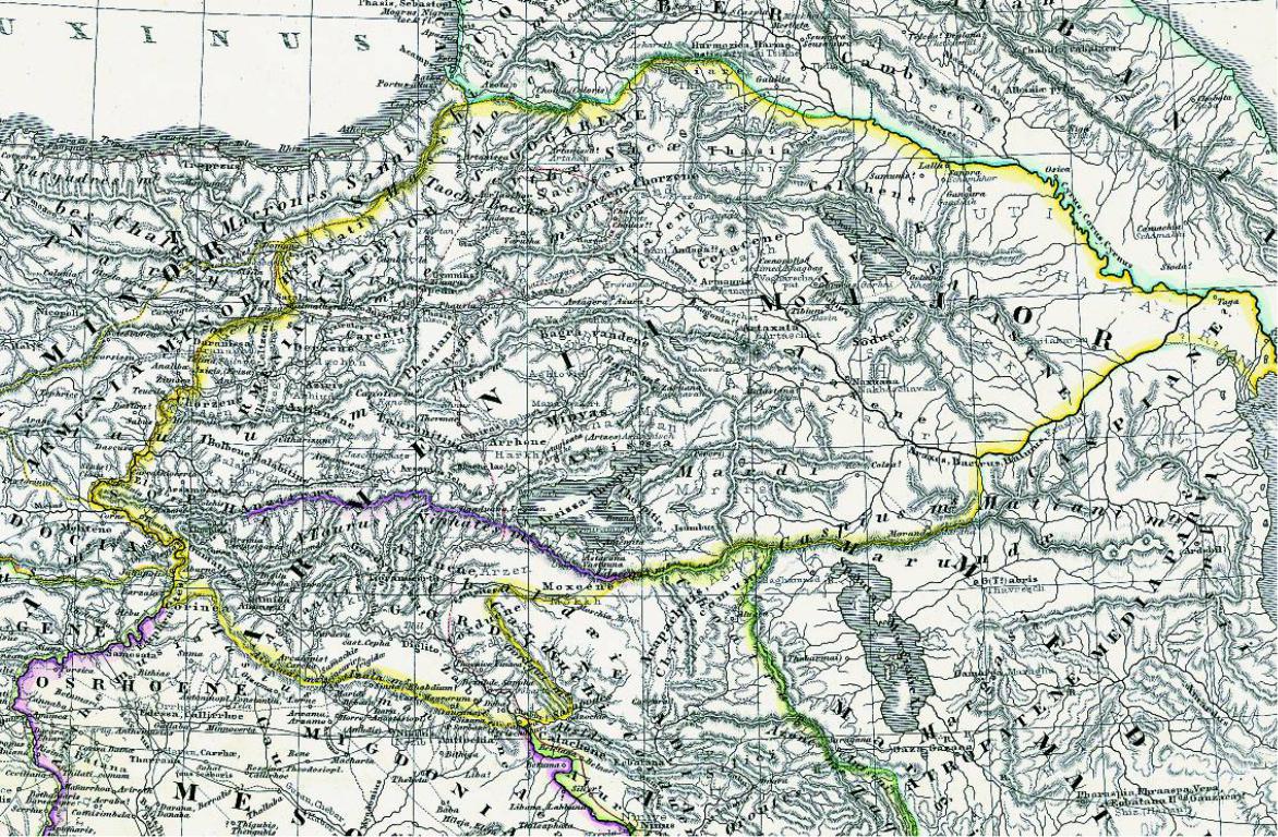
For general area of Armenia see detail map Fig. 117a. Size 50x34cm
Private collection – London, Ref. RG55
210
117
211
118a
212
118
Fig.118/118a
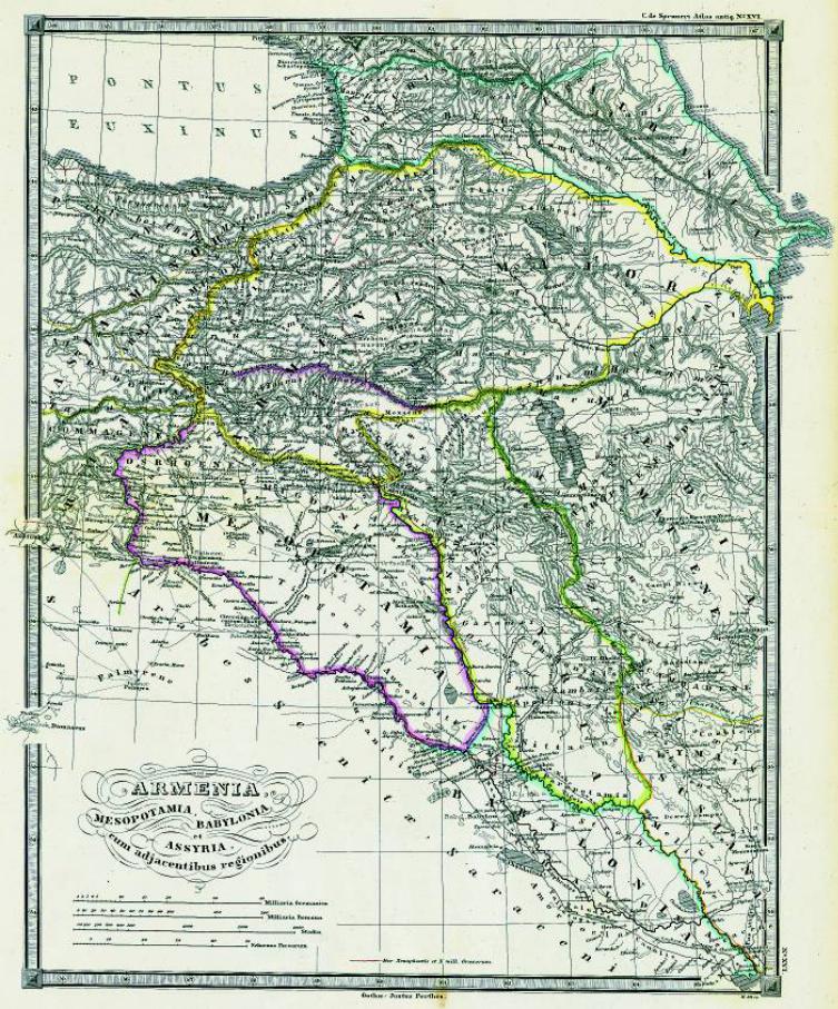
‘Armenia, Mesopotamia, Babylonia and Assyria with Adjacent Regions’ is taken from the Atlas Antique ofKarlvonSpruner(1803-1892),published in 1865. This is already a relatively accurate and modern map, showing most of the important landmarks, cities and towns. Most of the names are written both in Latin and in the vernacular (in lighter Latin script).
Similar to the map of Malte-Brun (Fig. 110), this map shows ancient Armenia with its provinces and gives the old Armenian names of towns and provinces.HereAtropatene (Azerbaijan)isshown within the territory of Media, south of the River Arax.
The map contains an unusual amount of topographical detail.
The enlarged map Fig. 118a shows the area of Armenia in detail.
Size 35x41cm
Private collection – London, Ref. RG33
213
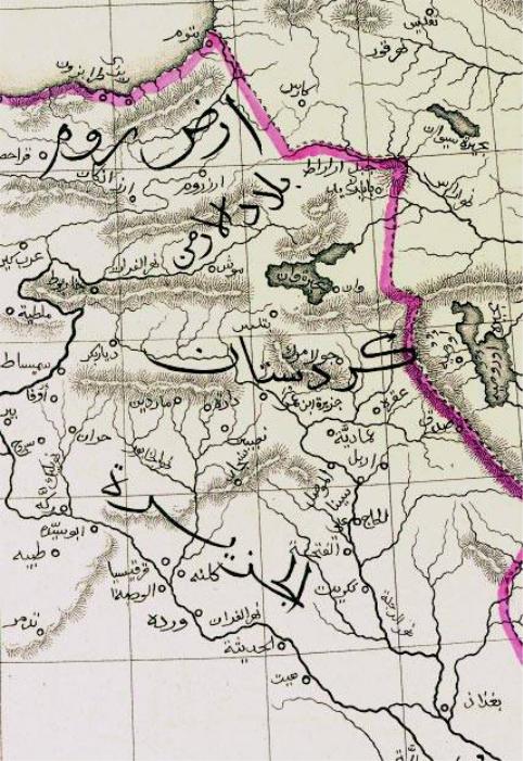
Fig. 119/119a |
|
|
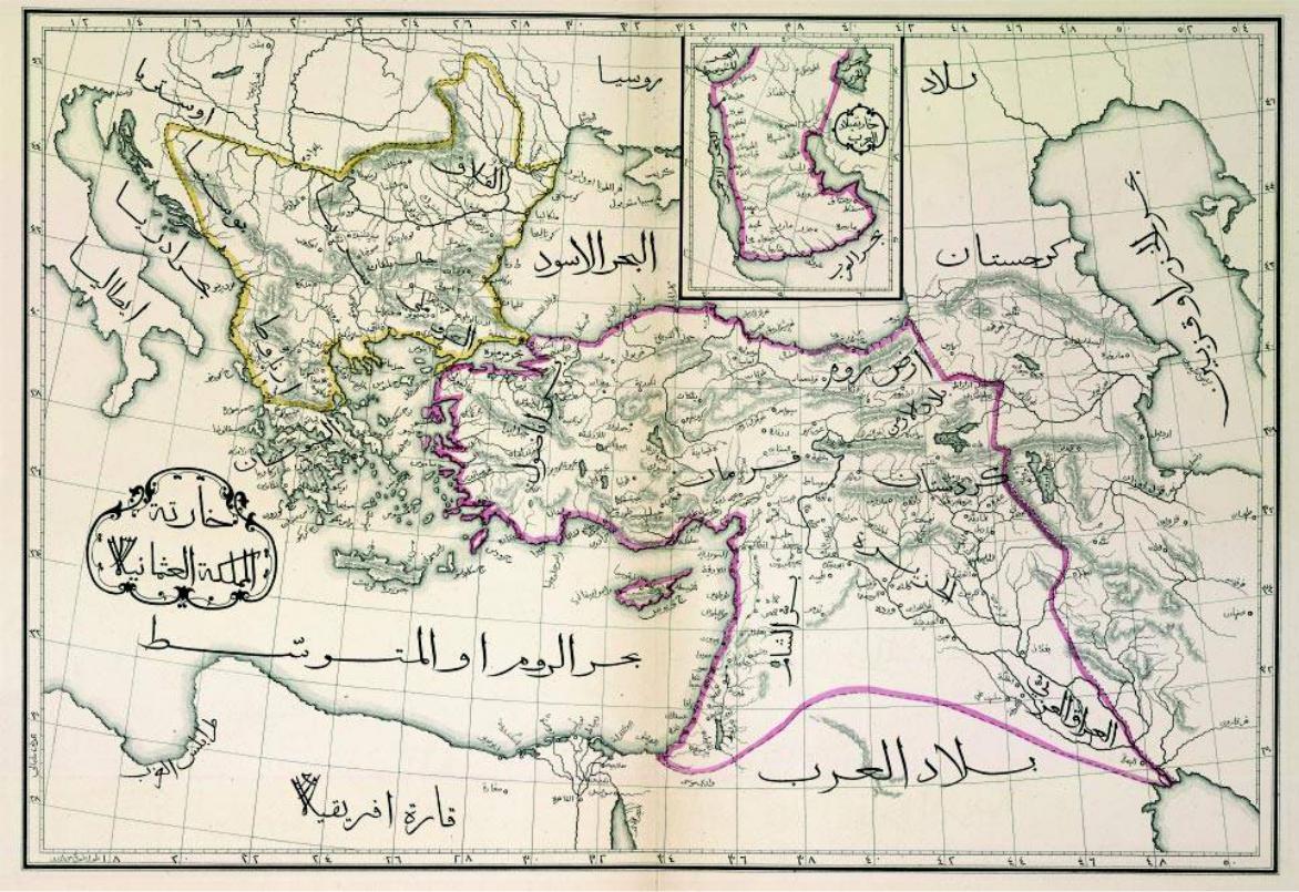
This map of the ‘Ottoman Country’ (Turkey) is from the atlas of the world printed in Arabic in |
|
|
Constantinople in 1867. The atlas contains maps of the hemispheres, the continents and the coast |
|
|
of Sham (the eastern Mediterranean). |
|
|
In this map the territory of Armenia is divided between the Russian and the Ottoman Empires. |
|
|
The regions of Van and Erzerum, although within the territory of the Ottoman Empire, bear the |
|
|
name Bilad Arman (Region of Armenia) and are considered to be Armenian lands. This area |
|
|
includes the cities of Bayazid, Van, Erzerum, Bitlis, Moush and Erzinjan. The delineation of the |
|
|
border between Persia, Turkey and Russia is very similar to that in Weller’s work, Fig. 117. |
|
|
The territory to the south of Armenia, below the region of Van and Bitlis, is named Kurdistan. |
|
|
For region of Armenia see detail map Fig. 119a. |
|
|
Size42x29cm |
119a |
|
British Library – London, Maps 42.d.1, f.2 |
||
|
214
119
215
120
216
Fig. 120
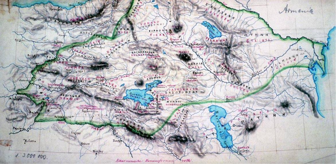
Heinrich Kiepert (1818–99) studied history, geography, philosophy and archaeology at Berlin University and in his youth travelled to Anatolia and Armenia. He is considered to be one of the mostimportantcartographersofthenineteenthcenturyandcertainlythemostimportantGerman cartographer of that era. He wrote many articles and prepared maps of the Middle East and Armenia, which he knew intimately. Later he learned Arabic, Persian and Armenian.
During60yearsofactivelifeKiepertproducedover600atlases,mapsandotherrelatedworks.His maps, full of detail, are of the highest quality and accuracy.
The unpublished manuscript map reproduced here, entitled ‘Armenia’, gives the names of the Armenian provinces and cities in both Greek and Armenian (using Latin script). The details shown on the map are precise and clear.
The green line shows the borders of Armenia according to the seventh-century Armenian geographerandhistorianAnaniaShirakatsi’stextAshkharhatzuytz (Ašxarhac´uyc –WorldMirror). See also Figs 92, 93 and 97.
Size24x17cm
Staatsbibliothek – Berlin, Kart U 7880
Fig. 121/121a
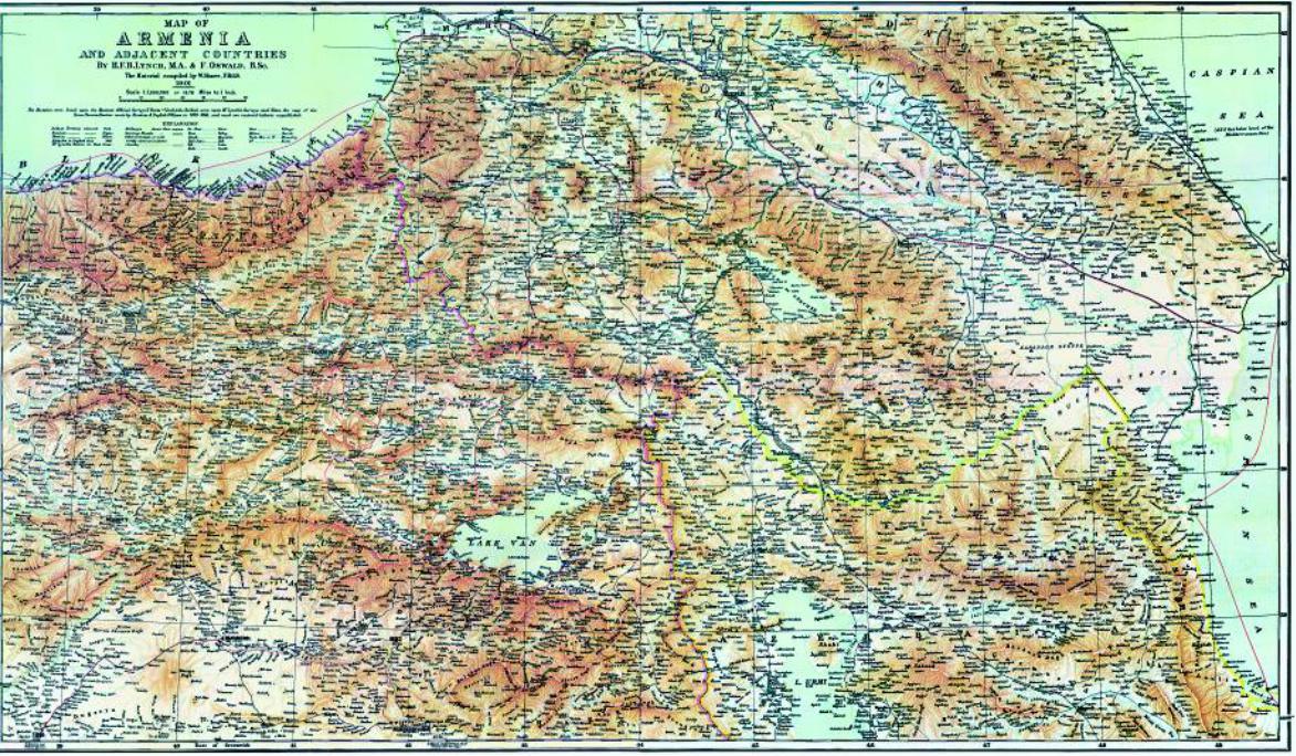
This map is entitled ‘Map of Armenia and Adjacent Countries’ and was prepared by the IrishBritishtravellerandgeographerH.F.B.LynchandbyF.Oswaldin1901.Themapaccompaniesthe two-volumetravelandhistorybookArmenia,TravelsandStudies byLynch,printedinLondonin1901. LynchwasveryinterestedinArmeniaandtwicetravelledtothearea,firstin1893,andthenin1898. His book contains many sketches, maps and unique photographs of the country and its peoples, which today remain important historical documents.
The map shows all the geographical features and contains a large amount of detail, such as the names of villages, rivers, mountains and their heights, and the borders of vilayets and countries. It isnoteworthythatatthetime,theterritoryofRussian(Eastern)ArmeniaincludedKars,Ardahan, Childir, Igdir, Bayazid and Mount Ararat.
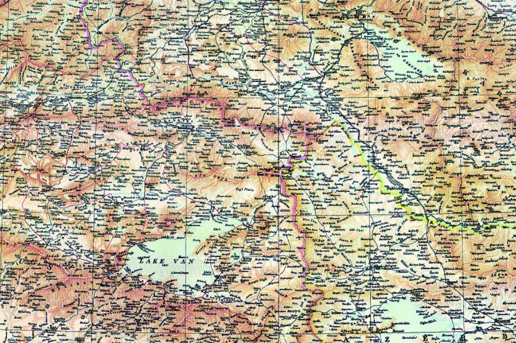
The enlarged detail Fig. 121a shows the central area of Armenia. Size97x57cm
Private collection – London, Ref. RG81
217
121
218
121a
219