

Galichian R., Historic Maps of Armenia the Cartographic Heritage
.pdfFig.110
This map, entitled ‘Asia Minor, Armenia, Circassia and Syria’, is by Conrad Malte-Brun (1775– 1826),aDanishcartographerwhoworkedinParis.HisAtlas Complet,whichcontainsthismap,was published in 1812.
Although the map was published at the beginning of the nineteenth century, its division of Armenia is very different from that in earlier ones. Here the area of historic Armenia is outlined
and the names of the provinces are given. The shape of the lakes in the area, though still not correct, is much improved. Once again the area of Atropatene (Azerbaijan) is shown to the south oftheRiverArax,withintheterritoryofMedia (Persia).
Size20x22cm
Private collection – London, Ref. RG48
200

Fig.111
This watercolour of Echmiadzin is from the large manuscript collection of the British painter Sir Robert Ker Porter KCH (1777–1842), which he prepared during his travels in Georgia, Armenia, Iraq and Persia in 1817–20. The volume is entitled The Caucasus, Persia, Babylonia with notes, maps, plans, surveys, views and other drawings of interesting subjects.
It contains watercolours, drawings, sketches and plans of various interesting sites and buildings in Georgia, Armenia and Persia, concentrating mainly on Isfahan and Persepolis. The sketches of Armenia include watercolours of Echmiadzin, Mount Ararat, Erivan (Yerevan), the Monastery of
Geghard and the pagan temple of Garni and a few others.
The view of Echmiadzin shows the main cathedral with its protective walls, beyond which the Monastery of Saint Gayane can also be seen. The background is dominated by the large mass of MountArarat.
Size 59x33cm
British Library – London, Add MS. 14758
201
112a
Fig. 112/112a
TheAtlas of the World according to the geographers of France, England, Germany and Russia,inArmenian, was engraved in Paris under the sponsorship of Hovhannes Amira Dadean. It was printed in San Lazzaro, Venice, in the year 1849.
The atlas contains maps of the solar system, the continents, the Ottoman Empire and Armenia. It is the first atlas in Armenian to contain text as well as maps. All the maps of the atlas are artfully prepared, and skilfully etched and coloured. These are on a par with the best atlases of other famous European cartographers.
This map of the Ottoman Empire is the penultimate map in the atlas and depicts the area occupied by the empire during the period. It is a beautifully coloured large-scale map with much detail.
The area of Armenia is shown in the detail 112a. Size90x60cm
Private collection – London, Ref. RG79
Also British Library – London, Maps 145.2.24
202

112
203

113a
Fig.113/113a
ThismapisfromthesameatlasasMap112,namelyAtlas of the World according to the geographers of France, England, Germany and Russia inArmenian,whichwasengravedinParisunderthesponsorship of Hovhannes Amira Dadean and was printed in San Lazzaro, Venice in the year 1849.
For details about the work see description of Fig. 112.
This map of ‘Armenia’ is the last map in the atlas and depicts the area of historic Armenia in the Middle Ages. It comprises beautifully coloured and detailed large-scale maps of the towns and
provincial divisions, as well as geographical features of Armenia. The detail Fig. 113a shows the central part of Armenia.
Size90x60cm
Private collection – London, Ref. RG80
Also British Library – London, Maps 145.2.24
204

113
205

Fig.114
This map of ‘Ancient Persia Elam with Adjacent Countries’ is taken from John Dower’s (fl. 18251863) Atlas published in the 1850s.
The map shows the early kingdoms existing in the area, with Asia Minor divided into various countries,includingArmenia. Atropatene (Azerbaijan)isshownasaprovinceofancientPersia.In
themapLakeVanisnamedArissa (Arjesh).ThetownsshownwithinArmeniaincludeSamosata, Satala, Chorsa (Kars)andNachuana (Nakhijevan).
Size22x16cm
Private collection – London, Ref. RG11
206

Fig.115
This sketch map of ‘Armenia’ is taken from the Rt Hon. Robert Curzon’s (1810–73) famous tome Armenia: A year at Erzeroum, and on the frontiers of Russia, Turkey, and Persia,printedinLondonin1854.Curzonwasworkingin theBritishEmbassyinConstantinopleandfrom1843wasamemberofthe team delimiting the Turko-Persian border.
The map, which is inserted at the back of the book, shows the area of Armenia,asitwasknownthen,includingtheregionsofVan,Bitlis,Bayazid, Erzerum,Moush,Bayburt,Kars,Ardahan,ErivanandGumri,aswellasthe twin peaks of Mount Ararat. Gumri and Erivan are shown in the territory under Russian rule, while the rest of the country is shown under Ottoman rule.
Size 10x15.5cm
Curzon’s Armenia,lastpage–Privatecollection

116a |
116b |
116c
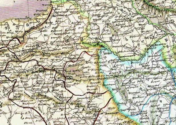
Fig. 116/116a/116b/116c
ThisOttoman TurkishmapisatranslationofanoriginalGerman map byHeinrichKiepert(1818– 99), based on the observations of von Vincke, Fischer and von Moltke, as well as Kiepert himself, andpreparedfortheGeneralStaffoftheGermanArmy.(FordetailsaboutKiepertseedescription of Fig. 120.) The German map was printed in Berlin in 1844 as ‘The Map of the Turkish Empire’ (Fig. 116b). In this map the area of Lake Van, Erzerum, Kharput, Bitlis, Kars and Ararat, located within the Ottoman Empire, is denoted as Armenia, with Kurdistan south of Lake Van.
The Turkish map shown in Fig. 116 is a translation of the original German map, and has a cartouche,whichreads:‘The map of the Turkish Empire was prepared and printed in the German language by Vincke, Fischer, Moltke and Kiepert, for the General Staff of Prussia. It was translated into Turkish at the Academy of War. The map was drawn and printed in Turkish and this is a copy of it. In the year AH 1267 (AD 1854).’
ThedetailofthemapshowninFig.116aisthewesternpartoftheempire,aswellasitsneighbouring countries. Lake Urumia in the west is within Ajamestan (Persia) and Lake Sevan in the north is located within the territory of Russia, with Lake Van within the Turkish Empire. The German version of the same area is reproduced in Fig. 116b.
The title of the German map is also reproduced in Fig. 116c.
208

In the Ottoman maps of 1803 (Figs 108 and 109) the area of Van and Erzerum is shown in bold letters as  – ‘Ermenistan’, i.e. Armenia, while in this map of 1854, the name of the same area, while still shown as basically Armenia, appears here in much smaller letters merely as
  – Ermani, which translates as ‘Armenian’ (see title underlined with double blue lines), whileKurdistanisboldlywrittenintheareatothesouthofLakeVan.Intheprocessoftranslation, all the names have been translated and kept as they were, yet somehow only the name of Armenia
116
has been reduced in size from the original German language print. For comparison refer to details 116a and 116b.
Sizeapp.92x62cm
116/116a: Österreichische Nationalbibliothek – Vienna, K.III.113 518 116b/116c: British Library – London, Maps 46970.(7)
209