

Galichian R., Historic Maps of Armenia the Cartographic Heritage
.pdfFig. 91
KâtibChelebi’sgeographicalworkJehân Numâ – |
(MirroroftheWorld)wastakenupby |
thefirstTurkishprinterIbrahimMüteferrika(ofHungarianorigin),whoprinteditin1732/33.The |
|
author had completed only the first part of the book before his death in 1657. (See Figs 69, 70 and |
|
71.) |
|
Theprintedversionofthebook,whichwaseditedandcompletedbyMüteferrika,hasmoredetails |
|
|
than the original, which the editor obtained from the texts of Ibn-Bahrâmi as well as from the |
|
|
notes of Chelebi himself. Chapter 41 of the printed version describes Western Armenia, which at |
|
|
the time was under Ottoman rule, and specifies its borders. Chapter 39 gives details of Eastern |
|
|
Armenia, which was under Persian domination. In general terms, it seems that Chelebi has used |
|
|
much information provided by Abulfedâ in his Taqvim ul-Boldân as well as al-Istakhrî and other |
|
|
Islamic geographers. (See Fig. 23.) |
|
|
The book contains 40 diagrams and maps, which include planet maps, zodiac maps, diagrams of |
|
|
the eclipses, hemisphere maps and maps of the continents as well as various regions of the world, |
|
|
some quite detailed. Most of the maps have been based on European atlases and maps. |
|
|
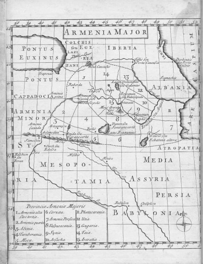
Themapreproducedhereis‘the map of Circassia, Abkhazia, Daghestan, Shirvan, Gurjistan[Georgia], |
|
|
Revan [Yerevan],Kars, Childir, Trabizond and Erzerum’.Althoughthetextspecifiesthatthecitiesof |
|
|
Van,Kars,ErzerumandmanyothersarepartofGreaterArmenia,themap,whichwasinsertedby |
|
|
Müteferrika, only shows the outlines of the vilayets (counties), without delineating borders of |
|
|
countries. (See also Figs 64 and 66 for similarities.) |
|
|
InthismaptheeasternterritoriestothenorthoftheRiverAraxarenamedShirvanandDaghestan. |
|
|
Size26x31cm |
91 > |
|
British Library – London. Or. 80.a.7, bet. pp431–2 |
||
|
170

171
92
172

9 3
Figs 92 and 93
This is a map of Armenia in the early medieval period. The map accompanies the printed text of the Latin and Armenian edition of Movses Khorenatzi’s History of Armenia, which also incorporates the geographicaltextcalledAshkharhatzuytz (Ašxarhac´uyc –WorldMirror) attributedheretoMovsesKhorenaci,butlatelyattributedtotheseventhcenturypolymath,AnaniaShirakatzi.TheLatintranslationisbyWilliam and George Whiston and the book was published in 1736, in London.
The map has been drawn taking into consideration the descriptions of Ashkharhatzuytz.Itshowsthe15provincesofGreaterArmeniaandtheir approximate borders. Lesser Armenia is in Eastern Anatolia, just to the west of Greater Armenia. The external borders of Greater Armenia are shown by broken lines, while the borders of the provinces are indicated by dotted lines.
ThetownsshownincludeErivanum (Yerevan),Valarsapata (Vagharshapat orEchmiadzin),Arzerum orCarin (theoldArmeniannameofErzerum– Karin; in Greek Theodosiopolis), Vannum or Semiramocerta (Van or Shamiramakert),Betlis (Bitlis),Arsamosata (Arshamashat)andNaxuanum (Nakhijevan).MountAraratorMasis isalsoshown.TheArmeniannameof the River Arax(es) – Erasches (Yeraskh) is also mentioned. Comparing thismapwiththePtolemaicversionofthesamearea,itcanbenotedthat the earlier Ptolemaic maps had an acceptable degree of accuracy.
Fig. 93. This is the title page of the book in which Fig. 92 is contained. Size 185x225mm (map) inside the cover
Private collection – London
173

94a
Fig. 94/94a
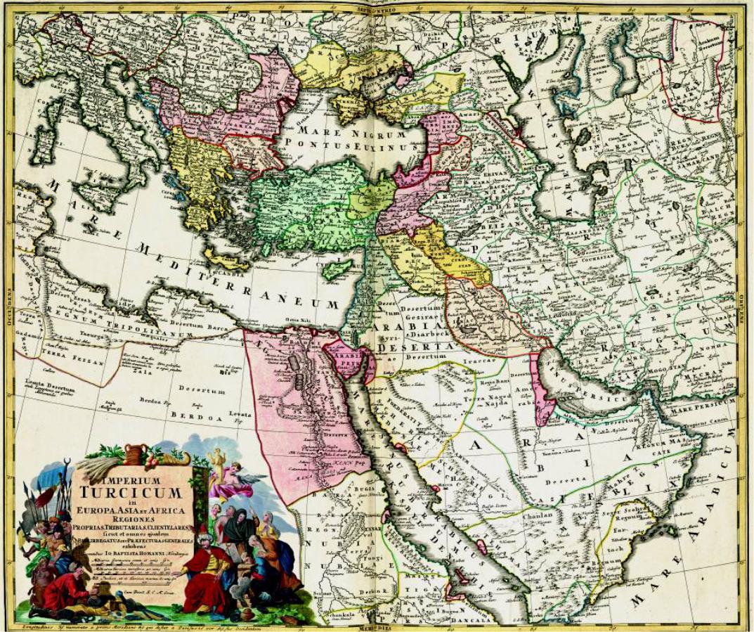
“This map of the ‘Turkish Empire’ is Plate 13 of Nouvel Atlas de la Societé Generale published by JohannBaptisteHomann(1663–1724)inStPetersburgin1748.ThecartographerswereGuillaume Delisle and Johann Mathias Hase.
Although the atlas is dated 1748, but the map of the Turkish Empire included in it actually dates from 1737. This map is somewhat similar to that shown in Delisle’s own atlas. Here Armenia appearswithintheOttomanEmpire,withKarabaghandtheprovinceofErivan aspartofthePersian Empire. The names of the areas to the west of the Caspian Sea are Dagestan, Lesgi and Shirwan. Moghan and Adherbaizan (Azerbaijan) are placed to the south of the River Araz (Arax), within Persia. In this map, similarly to Delisle’s other maps, the lakes of Van and Urmia(Chahi)areshown almost joined.”
Fig.94a shows details of the region of Armenia. See description of Fig.117 for details concerning Karabagh.
Size 58x49cm
British Library – London, Maps C.45.f.6 |
94 > |
174
175

95a
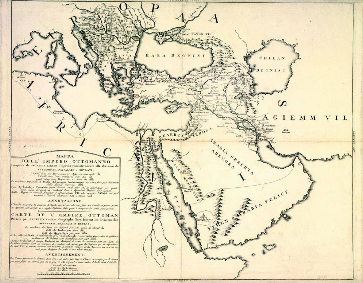
Fig. 95/95a
This is an important map, since it is the first map by a Turkish geographer, in this case, Abubekir Efendi, to be published in the west. The original map can be found in the bilingual large folio book L’Etat Militaire de l’Empire Ottoman, by Count Lodovico Marsili, published by La Hey in Amsterdam in 1732 (See SOAS London, Ref. ED.73.1). The book also contains another map of the same outline, but without detailed boundaries of the countries. The author is the same person who, in 1691 had commissioned Eremia Keomiurdjian to prepare a map of the Armenian churches located inside the Ottoman Empire. (See Figure.83). The map reproduced here is a reprint dated 1740 and its cartouche is bilingual, Italian and French. It is entitled “The Map of the Ottoman Empire, divided into Beylerbeylics, Pashaliks and Beyliks (Baronies)…”.
Thelegendexplainsthevarioushierarchicaldivisionsoftheempire.Beylerbeylicsareabbreviated as Vil. (Vilayet), which in Turkish can refer to the area of a province or a whole country. These types of divisions correspond to the divisions shown on the manuscript map of Keomiurdjian, where they are indicated by one, two or three staffs.
InthemapthevilayetofArmenia(Erman Vil.) includesthecitiesof Arsum (Erzerum),Malasghert, Vaan, Kars, Baisit (Bayazid),Kutur, Adiljivaz andothers.ThelocationofLakeVanisshiftedeastward, thus creating a distorted image as far as the relationships of the localities are concerned. For example, Kars, which is situated some 150 kilometres north-west of Bayazid, is shown 100 Italian miles to its east.
Detail Fig. 95a shows the area of Armenia enlarged.
Size 57x54cm |
|
British Library – London, Maps 43305.(16) |
95 > |
176
177
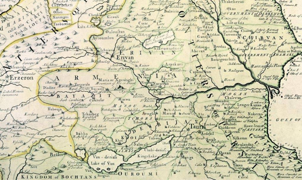
Fig. 96/96a
The title of this map is ‘A new map of the Caspian Sea and the countries adjacent, made by the order of the late Czar’. It was prepared by John Senex and printed in London c. 1742.
The map is the English translation of part of Delisle’s map entitled ‘Carte des Pays voisins de la Mer Caspiene’ dating from 1730 and reproduced in Fig. 90.
All the errors and shortcomings of Delisle’s map are also reflected in this map. Lake Van and Chahi (King’s Lake or Urmia) are shown joined, when in fact they are some 150 kilometres apart. This means the lands of Armenia and the Iranian Province of Azerbaijan are compressed together, dislocating many towns and cities. Lake Sevan is shown with the incorrect orientation, but does include the island and the monastery.
PersianArmeniaincludestheareasofErivan (Yerevan),Baiazit andVan.TurkishArmeniaincludes
96a
96 >
Erzeron (Erzerum), Cars and Betlis (Bitlis). The name of Echmiadzin is spelled Ichniani. Mount Ararat bears its Armenian name (Masis – Macis) as well as the names in Turkish (Agerdaghi – Agridagh) and Ararat.
Next to Lake Van an area has been marked Republick of Jesidis. The Yezidis are a non-Muslim Kurdish sect, whose religious beliefs include elements of sun-worship. A tightly knit community, they are now largely concentrated in the Republic of Armenia.
Fig. 96a shows the area of Armenia in detail. Size 525x425mm
British Library – London, Maps 141.a.1.(17)
178

179